
Mapping of chloride deposits on Icaria Planum on Mars, and its possible correlation with the Uyuni salt flat in Bolivia
- 1Universidad Mayor de San Andrés, La Paz, Bolivia (njimeno@umsa.bo)
- 2Constructor University, Physics & Earth Sciences, Bremen, Germany (jsuarezvalencia@constructor.university)
Introduction
Salt flats are deposits originated from the evaporation of mineral-rich bodies of water, these deposits are usually located in places with growing aridity, which results in the accumulation of chlorides where water has disappeared [1]. These deposits are usually found in the bottom of dried or ephemeral lakes, where the evaporation of water exceeds the recharge, and chlorides are precipitated. Salt flats are important planetary analogues due to their extreme environmental conditions and their resemblance to the processes occurred in other planetary surfaces, especially on Mars [2].
[3] identified several outcrops of chlorides in the martian surface using data from the Thermal Emission Imaging System (THEMIS), on board Mars Odyssey [4]. Most of these locations have been covered by high resolutions datasets, but detailed analysis of most of them remains to be done. In this work we compare one of these locations, near a crater system in west Icaria Planum (-44.22°, -125.99°), with the Uyuni salt flat in Bolivia (-20°, -67°), the largest deposits of this type on Earth, to evaluate the potential of Uyuni as an environmental analogue of Mars.
Data and Methods
For Mars, we used four types of datasets. For the visible range we utilized the global CTX mosaic and two panchromatic and colour HiRISE images [5]. We used two hyperspectral CRISM cubes to check the mineralogy [6]. We used the global MOLA DEM for terrain information (Smith et al., 2001). Finally, we checked the global THEMIS day and night global mosaic [4]. For Earth, we used Landsat-8 images [7].
To analyse the geological setting and evolution of Icaria Planum we used a hybrid mapping approach, incorporating geomorphological and spectral information in a single product [8]. We first created geomorphological units, which were later refined or modified according to the spectral information. We then compared our results with satellite images and geological maps of the Uyuni salt flat. The analysis and mapping of the data were done in the geoprocessing software QGIS with the aid of the Mappy plug-in [9].
Results and discussion
The chloride deposits in Icaria Planum are located on top of a wide and flat area, the zone is a volcanic plateau of late Noachian age according to the global map of [10]. The plateau is surrounded by impact craters, but it is the lowest terrain in the surroundings. Spectral signatures from the CRISM cubes confirm the presence of chlorides in the northern part of the plateau (Figure 1). They mainly appear as unaggregated blocks scattered in the plateau, only some spots show a continuous slab of material, which implies the material has been heavily reworked (Figure 2). Between the chloride deposits are some field of mafic dunes, which are the result of the erosion of the original lavas materials that flooded the zone.
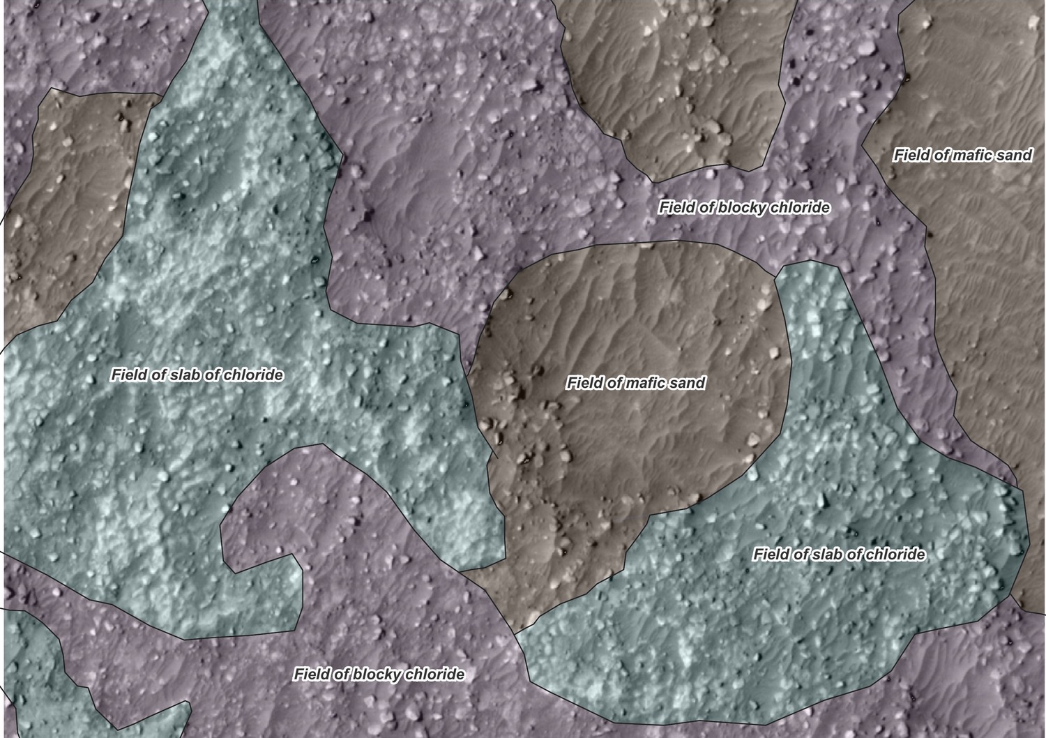
Figure 1: Spectral signature of a CRISM cube, the positive slope at 2000 nm is typical of chlorides.
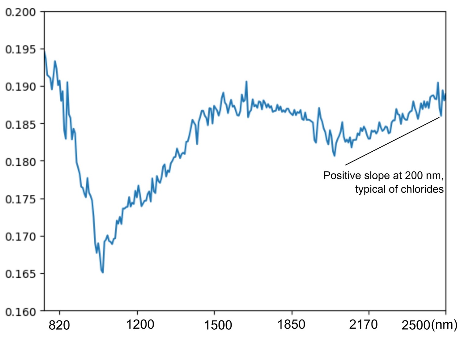
Figure 2: Sample of the typical structure of the flat area where chlorides accumulate.
This distribution of chlorides differs from the typical emplacement of martian chlorides defined by [11], these authors showed that most of the chlorides, although being local depocenters, are accumulated in slopes and closed systems. The deposits in Icaria Planum are widespread and scattered without relation to the slope, which implies they are similar to playa like deposits, as is the case in the Uyuni salt flat [12].
The Uyuni salt flat is not only similar to the Icaria Planum deposits because of its formation, Uyuni is located high in the Andean altiplano, at 2670 m.a.s.l, which creates extreme conditions regarding radiation, temperature, precipitation, and salinity [12]. This resemblance makes Uyuni an integral analogue of at least some of the chloride-rich zones of Mars.
Conclusions
The mapping of the Icaria Planum deposits showed that these chlorides are similar to the Uyuni salt flat, which showcases the importance of the last one as a planetary analogue, and the diversity of salt formation processes that acts in the martian surface.
References
[1] McKnight et al. (2023). Distinct Hydrologic Pathways Regulate Perennial Surface Water Dynamics in a Hyperarid Basin.
[2] Cabrol, N. A., & Grin, E. A. (2003). Overview on the formation of paleolakes and ponds on Mars.
[3] Osterloo et al. (2008). Chloride-Bearing Materials in the Southern Highlands of Mars.
[4] Christensen et al. (2004). The Thermal Emission Imaging System (THEMIS) for the Mars 2001 Odyssey Mission.
[5] McEwen et al. (2007). Mars Reconnaissance Orbiter’s High Resolution Imaging Science Experiment (HiRISE).
[6] Murchie et al. (2007). Compact Reconnaissance Imaging Spectrometer for Mars (CRISM) on Mars Reconnaissance Orbiter (MRO).
[7 ]Roy et al. (2014). Landsat-8: Science and product vision for terrestrial global change research.
[8] Aileen Yingst et al. (2023). A Geologic Map of Vesta Produced Using a Hybrid Method for Incorporating Spectroscopic and Morphologic Data.
[9] Penasa, L., & Brandt, C. H. (2021). europlanet-gmap/mappy: Latest (latest) [Software].
[10] Tanaka et al. (2014). Geologic map of Mars.
[11] Leask, E. K., & Ehlmann, B. L. (2022). Evidence for Deposition of Chloride on Mars From Small‐Volume Surface Water Events Into the Late Hesperian‐Early Amazonian.
[12] Risacher, F., & Fritz, B. (1991). Quaternary geochemical evolution of the salars of Uyuni and Coipasa, Central Altiplano, Bolivia.
How to cite: Jimeno Ruiz, N. and Suarez Valencia, J. E.: Mapping of chloride deposits on Icaria Planum on Mars, and its possible correlation with the Uyuni salt flat in Bolivia, Europlanet Science Congress 2024, Berlin, Germany, 8–13 Sep 2024, EPSC2024-483, https://doi.org/10.5194/epsc2024-483, 2024.