Boulder Morphology on Asteroid Bennu
- 1German Aerospace Center (DLR), Institute of Planetary Research
- 2Luleå University of Technology (LTU)
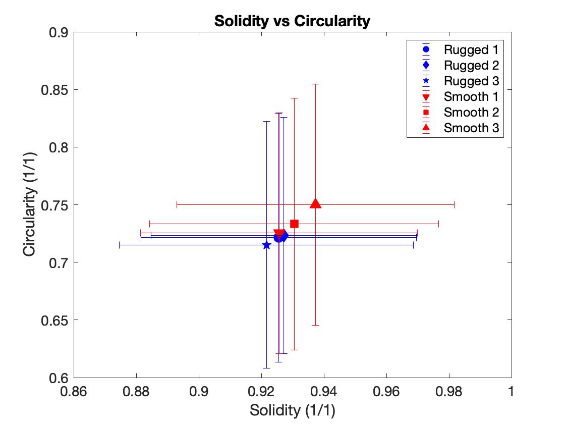
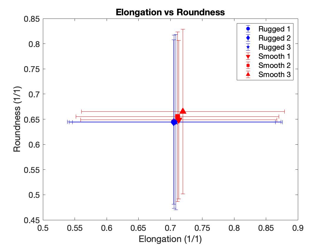
NASA’s Origins, Spectral Interpretation, Resource Identification, and Security-Regolith Explorer (OSIRIS-REx) spacecraft arrived at the near-Earth rubble pile asteroid (101955) Bennu in December 2018, and took high resolution images of the surface (3). The images revealed that the surface is covered with boulders of various sizes (6). The morphology and orientation of these boulders can provide valuable information about the body’s history and mechanical properties (1,4). In this work, we use images taken by the OSIRIS-Rex Camera Suite (OCAMS) (6) to map the outline of boulders on Bennu in two different geologic units: a rugged unit and a smooth unit (2). This work was implemented using the open-source software QGIS (5). The parameters we found in QGIS are show in Figure 1. We compare the two units’ boulder morphology in terms of boulder roughness by looking at the shape factors solidity (to what extent a boulder is convex) and circularity (to what extent a boulder’s perimeter is similar to the perimeter of a circle with the same area). The solidity plotted against the circularity can be seen in Figure 2. We also looked at the boulder shape by studying the shape factors elongation (how elongated a boulder is) and roundness (to what extent the area of the boulder resembles the area of a circle with its radius equal to the boulder’s semi-major axis). The elongation plotted against the roundness can be seen in Figure 3. Despite the geologic differences of the smooth and rugged units, we find no significant difference in boulder roughness and shape between these two units. Both regions’ boulders possess a large variation of values that overlap significantly. However, we do find that the smooth unit tends to have smaller boulders (0.579±0.35) m with more boulders mapped (total 2426) than the rugged unit ((0.711±0.48) m, total 1774 boulders mapped). Finally, we found that smaller boulders tend to be rounder and less rough than larger boulders in both units, however, this may be an effect of the image resolution. This work implies that boulder morphology is relatively uniform over the surface of Bennu, also indicating that the mechanical material properties are similar in the two units. Although the units are geologically distinct, the material they are made of seems to be homogenous.
Figure 1: The boulder parameters identified in QGIS. A is boulder area (blue area), H is convex hull area (orange area), P is boulder perimeter(red line), a is the major axis and b is the minor axis. The green circle is the minimum circumscribed circle.

Figure 2: The shape factors that describe boulder roughness, solidity and circularity, plotted against each other in the six studied regions.

Figure 3: The shape factors that describe boulder shape, elongation and roundness, plotted against each other in the six studied regions.
(1): P Cambianica et al. “Quantitative analysis of isolated boulder fields on comet 67P/Churyumov-Gerasimenko”. In: Astronomy & Astrophysics 630 (2019), A15. doi: 10.1051/0004-6361/201834775.
(2): ER Jawin et al. “Global geologic map of asteroid (101955) Bennu indicates heteroge-
neous resurfacing in the past 500,000 years”. In: Icarus 381 (2022), p. 114992. doi:
10.1016/j.icarus.2021.114467.
(3): DS Lauretta et al. “OSIRIS-REx: sample return from asteroid (101955) Bennu”. In:
Space Science Reviews 212 (2017), pp. 925–984. doi: 10.1007/s11214-017-0405-1.
(4): T Michikami and A Hagermann. “Boulder sizes and shapes on asteroids: a comparative
study of Eros, Itokawa and Ryugu”. In: Icarus 357 (2021), p. 114282. doi: 10.1016/
j.icarus.2020.114282
(5): QGIS.org (2024). QGIS Geographic Information System. Open Source Geospatial Foundation Project. http://qgis.org
(6): B Rizk et al. Spectral Interpretation, Resource Identification, Security, Regolith Explorer
(OSIRIS-REx): OSIRIS-REx Camera Suite (OCAMS) Bundle. urn:nasa:pds:orex.ocams,
NASA Planetary Data System. 2019.
How to cite: Svanström, E., Otto, K., and Schröder, S.: Boulder Morphology on Asteroid Bennu, Europlanet Science Congress 2024, Berlin, Germany, 8–13 Sep 2024, EPSC2024-505, https://doi.org/10.5194/epsc2024-505, 2024.