
Testing the FlyRadar instrument in glacial environment on Earth for future ice/water investigations on Mars
 1,5,6,6,7,6,
- 1International Research School of Planetary Sciences, Università Gabriele D’Annunzio, Viale Pindaro 42, Pescara, Italy (francesca.mancini@unich.it)
- 2CO.RI.S.T.A., 80143 Naples, Italy
- 3UCBL, CNRS, UMR 5276 LGL-TPE, France
- 4Hyperion Seven, Claix, F-38640
- 5HUN-REN, CSFK, Konkoly Observatory, H-1121 Budapest, Konkoly Thege 15-17, Hungary
- 6Centrum Badań Kosmicznych Polskiej Akademii Nauk (CBK PAN), Bartycka 18A, 00-716 Warszawa, Poland
- 7Univ. Grenoble Alpes, CNRS, CNES, IPAG, 38000 Grenoble, France
- 8Ibn Battuta Centre, Université Cadi Ayyad, Boulevard Abdelkrim Al Khattabi, Marrakech, Morocco
Introduction
The goal of the FlyRadar project (a 2020 Horizon 2020 MSCA-RISE project funded by the European Commission) was to design and develop a multimodal Ground Penetrating Radar (GPR) and Synthetic Aperture Radar (SAR), multi-frequency radar system installed on an Unmanned Aerial Vehicle (UAV), tailored for exploration on Mars, and validated through testing on Earth (Figure 1).
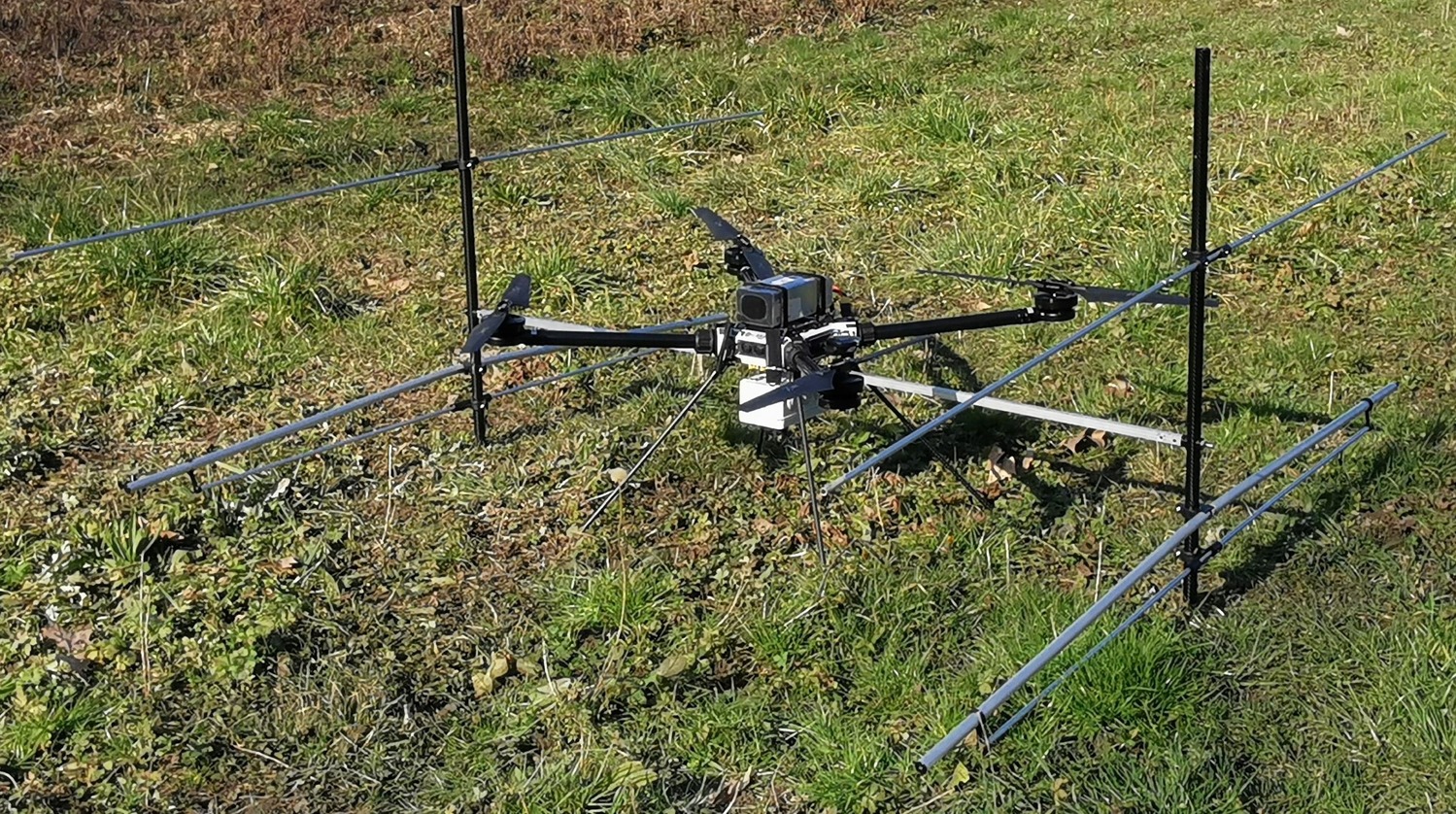
Figure 1: The FlyRadar instrument. The radar’s GPS is fixed to the drone’s battery in the center. A GoPro camera was added to film the ground.
A GPR is an active remote sensing instrument that emits electromagnetic waves and detects the waves reflected by discontinuities on the surface of the planet or contrasts in permittivity within its subsurface. Analysis of these echoes yields geometric and geological information about subsurface features, typically penetrating to depth of approximately 100 meters, contingent upon the permittivity of the material being surveyed.
The search for extraterrestrial resources, like ice or water, has been a key scientific objective in the human exploration of the solar system, with Mars being the second closest terrestrial planet and the most likely candidate to have ice/water resources [1]. Airborn surveys will be essential in both robotic and human exploration missions. The FlyRadar consortium's scientific team is also currently involved in some recent space exploration missions such as Mars Ice Mapper [2].
FlyRadar's scientific test campaigns have been planned, with an initial test scheduled in the glacial environment of the Alps followed by testing in the arid environment of Morocco. These tests aim to evaluate the integrated system capabilities in terms of operations and scientific data quality.
Testing area: the Miage Glacier
The Miage Glacier, as the most representative debris-covered glacier in Italy, serves as a crucial site for multidisciplinary scientific research. The Miage Glacier is located in the Veny Valley on the SE flank of Mont Blanc massif in the Alps (Italy, Valle d'Aosta, Courmayeur; Figure 2). Miage is a valley glacier, and it covers an area of 11 km2. The front of the right glacier tongue terminates at an elevation of 1730 m. The glacier is bordered by steep walls and exposed towards south-east.
The entire lower 6500 m of the glacier up to the elevation of 2450 m is completely covered with debris. It is 41,5 % of the total area. Mean slope of the debris cover surface is 6° (for the right tongue). Inner part of debris cover has hummocky surface with a lot of thermokarst depressions sometimes with lakes. Most often, there are no clearly defined ridges, but there are coloured stripes along the glacier in accordance with the debris lithology. The edges of the debris cover are represented by steep slopes. The average value of debris cover thickness is around 20-40 cm (Mihalcea et al., 2008). The maximum value is around 50-60 cm in the lowest parts of the lobes. The debris was accumulated here because of glacial ablation.
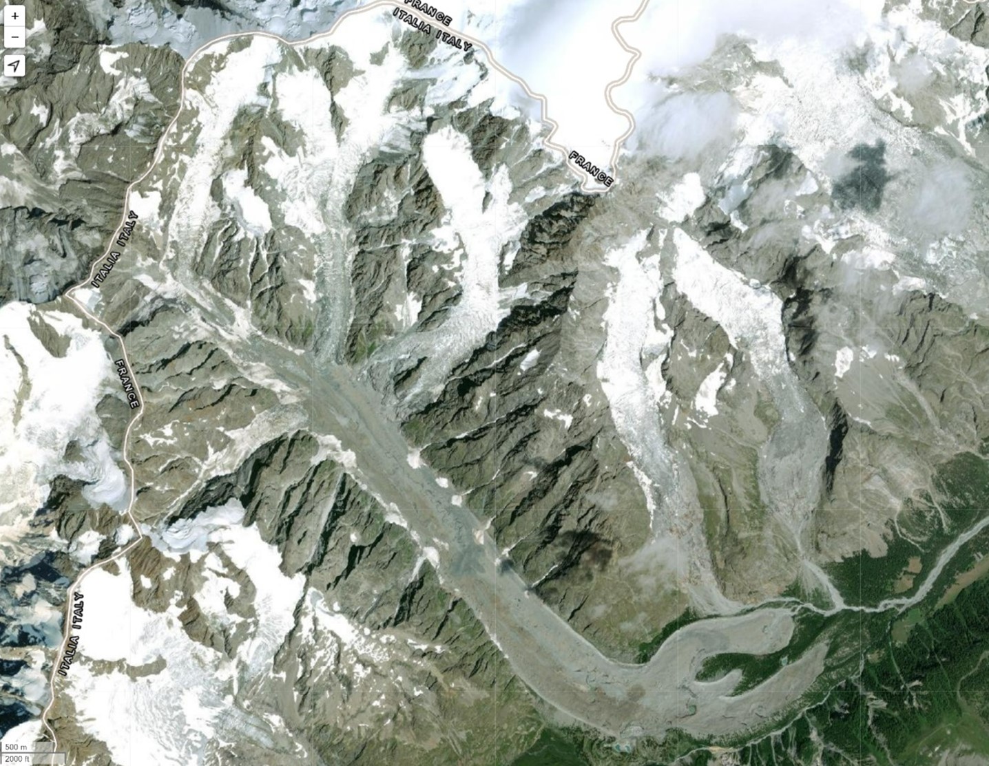
Figure 2: The debris-covered Miage Glacier.
Conclusion
Future space missions will extensively use drones for several tasks. It will be important for the analysis of the subsurface for scientific purposes but also for technical reasons (to identify subsurface water or ice, 3D mapping of geological features, to support infrastructure deployment on the surface, identification of resources, etc.). Although drones are going to be applied, there is a gap in space industry regarding the construction of low weight, low energy consumption and robust SAR systems that is exploited by the FlyRadar project. The aim of the FlyRadar project is to develop, test and build a radar system able to work in both GPR and SAR mode installed on board a UAV. Planned tests in glacial and arid areas at analog sites on Earth will aid in refining and optimizing the instrument, establishing a workflow to prepare it for Mars exploration.
Acknowledgement
The FlyRadar project was supported by the EU H2020-MSCA-RISE-2020 Grant agreement ID: 101007973.
References
[1] Nazari-Sharabian M., et al., 2020. Galaxies, 8(2), p.40.
[2] Amoroso M. et al., 2024. No. EGU24-10754 Copernicus Meetings.
[3] Mihalcea C. et al., 2008. Cold Regions Science and Technology, 52(3), pp.341-354.
How to cite: Mancini, F., Kokin, O., Alberti, G., Allemand, P., Grandjean, P., Augier, S., Castel, A., Neir, O., Senez, T., Kereszturi, A., Gurgurewicz, J., Kofman, W., Mège, D., and Ori, G. G.: Testing the FlyRadar instrument in glacial environment on Earth for future ice/water investigations on Mars, Europlanet Science Congress 2024, Berlin, Germany, 8–13 Sep 2024, EPSC2024-511, https://doi.org/10.5194/epsc2024-511, 2024.