
Extent and Nature of Clay-rich Deposits, from Oxia Planum to Mawrth Vallis
 1,1,1,1
- 1LGL-TPE, Lyon University, France (ines.torres-aure@univ-lyon1.fr)
- 2IAS, Paris-Saclay University, France
- 3LAM, Aix-Marseille University, France
Introduction:
The study of clay-rich deposits is key to understanding past water activity on Mars and its early habitability potential. Strong phyllosilicate signatures have been identified over the Mawrth Vallis plateau based on the OMEGA instrument [1]. Similarly, large clay-rich deposits have been detected in Oxia Planum [2], the landing site of the ExoMars Rosalind Franklin rover mission. The rover aims to investigate the Martian surface and subsurface with its two-meter-deep drill, searching for potential traces of past life preserved in these phyllosilicate-bearing units [3].
Aqueous alteration minerals from the selected landing site exhibit spectral features consistent with Fe/Mg-rich phyllosilicates, best fitted with vermiculite or saponite due to the position & shape of the 2.3µm absorption band, and a Fe2+ oxidation upward slope from 1µm to ~1.7μm [2]. These large clay units date back to the Noachian period [4]. 300km northeast, clays found in Mawrth Vallis are consistent with montmorillonite (Al rich) and nontronite (Fe3+/Al rich) smectites, as indicated by spectral absorptions at respectively ~2.2µm and ~2.3µm, as well as their overall shape [5]. These units are also dated to the Noachian period [6].
The proximity of both sites and their similar position straddling the crustal dichotomy calls for the investigation of the relationship between these two significant phyllosilicate-bearing regions.
Method:
Datasets: Given the expansive scope of our study area spanning from Oxia Planum to Mawrth Vallis, we used the OMEGA hyperspectral dataset (~300 to 4000 m/pix) [7].
Tools: We developed custom Python scripts to correct OMEGA cubes, map spectral criteria, and project raster data. Extraction of regions of interest (ROIs) and spectral analysis was done in QGIS using the EnMAP-Box plugin [8].
Cube corrections: Six correction steps have been implemented: (1) an atmospheric absorption band correction (“volcano-scan” method) [9]; (2) a Mars surface thermal contribution correction (gray body subtraction) [10]; (3) corrupted pixels and spectels are removed from the cube; (4) each spectrum is fitted and then divided by a linear regression continuum with tie points centered around 1.75µm and 2.14µm, where few clay minerals absorb [11]; (5) each spectrum is normalized by its maximum value to ensure a cube with homogeneous reflectance values and mitigate significant photometric effects resulting from changes in topography; (6) the local neutral mineralogy is removed using a “clean mean” method: the median spectrum of a 50-pixel-squared region – where pixels positive to the 2.3µm criteria have been masked, hence the “clean” median – is calculated and subtracted from each spectrum. This step improves the detectability of phyllosilicate absorption bands, as their local “neutral” component is removed.
Spectral criteria maps: We mapped the following criteria: 1.9µm band depth of most hydrated minerals, 2.2µm drop of Al-smectite, 2.3µm drop of Fe-/Mg-phyllosilicates [11] (Figure 1), and HCP & LCP pyroxenes [12] (green in Figure 2).
ROIs: We converted clusters of contiguous pixels where the detection criterion was higher than a predefined threshold to shapefiles using QGIS functions. Spectral analysis over a ROI was possible after making adaptations to the EnMAP-Box Plugin [8], which were contributed to the project: by selecting one (or multiple) polygons, we compute their median spectrum (Figure 2).
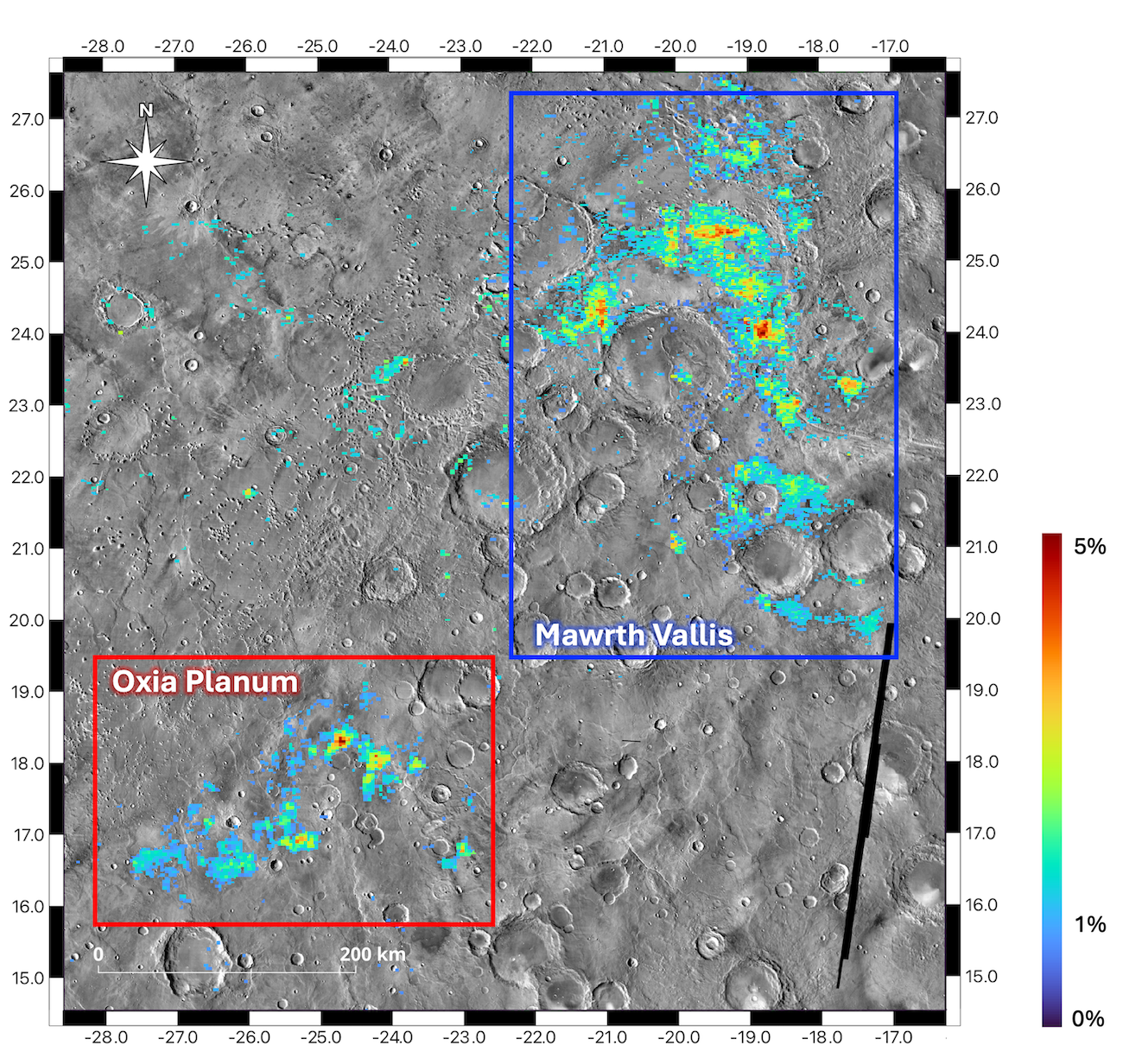
Figure 1: 2.3µm-drop spectral criteria (1% threshold). Basemap: THEMIS-day.
Results:
Our 2.3µm drop criterion map aligns with existing phyllosilicate maps of Mawrth Vallis and Oxia Planum (Figure 1) [13]. Spectral analysis reveals two distinct clay types, as introduced earlier: the “Oxia Planum”-like (red in Figure 2) and the “Mawrth Vallis”-like (blue in Figure 2).
Oxia Planum clays in Mawrth Vallis and vice-versa: We noticed two areas (ROI n°1 and n°4) exhibiting different characteristics than the region they belong to. Spectrum n°1 (in Mawrth Vallis) shows Oxia Planum-like features: Fe2+ upward slope up from 1µm to 1.6µm, and the position & shape of the 2.3µm absorption. Reflectance bumps at 1.6µm (instead of 1.7µm) and 2.6µm (instead of a plateau) can be explained by the presence of pyroxenes in this ROI, which lies above a green zone, as seen in Figure 2. Spectrum n°4 (in Oxia Planum) shows the same shape & absorptions as the Mawrth-Vallis one (n°3). Spectra n°2 and n°3 show less spikes, as signal-to-noise ratio increases with the square root of the pixel count.
Lava flows covering clays? Clay detections seem to be anticorrelated with dust (dark shades in Figure 2) and, often, pyroxenes (or with traces of it in their spectra, as in n°1). CTX imaging also reveals wrinkle ridge morphologies over green spots, suggesting that lava flows may have covered ancient clay-rich areas between Oxia Planum and Mawrth Vallis. Layered crater walls, observed with HiRISE, seem to confirm the presence of clays between these two major regions – more closely related than we initially believed, but showing signs of a different ancient aqueous history. We are now deciphering the stratigraphic relationship between the two types of clays, and broadening the scope of our study to the clay-rich margins of Chryse Planitia.
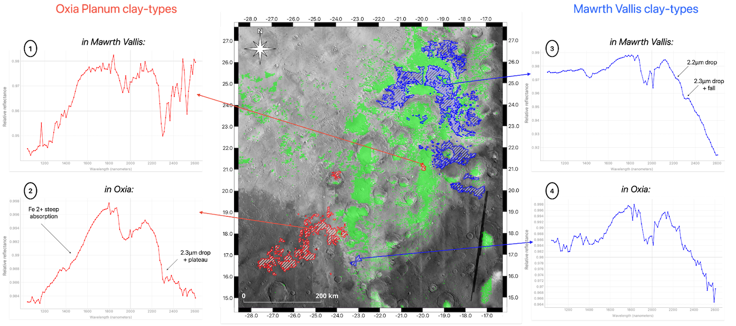
Figure 2: Mawrth Vallis (blue) and Oxia Planum (red) clays over pyroxenes (green) and OMEGA dust emission (greyscale) [14].
References: [1] Poulet F. et al. (2005) 438(7068), 623-627. [2] Carter J. et al. (2016) 47th LPSC, Abstract #2064. [3] Vago J. L. et al. (2017) Astrobiology, 17(6-7), 471-510. [4] Quantin-Nataf C. (2021) Astrobiology, 21(3), 345-366. [5] Bishop J. (2008) Science, 321(5890), 830-833. [6] Loizeau D. (2007) JGR: Planets, 112(E8). [7] Bibring J.-P. et al. (2004) ESA Spec. Pub., SP-1240. [8] Jakimow B. et al. (2023) SoftwareX, 23, 101507. [9] Langevin Y. et al. (2005) Science,307(5715), 1584-1586. [10] Jouglet D. et al. (2007) JGR :Planets, 112(E8). [11] Carter J. et al. (2013) PSS, 76, 53-67. [12] Ody A. et al. (2012) JGR: Planets, 117(E11). [13] Carter J. et al. (2023) Icarus, 389, 115164. [14] Audouard J. et al. (2014) Icarus, 233, 194-213.
How to cite: Torres, I., Carter, J., Quantin-Nataf, C., Volat, M., Millot, C., and Dehouck, E.: Extent and Nature of Clay-rich Deposits, from Oxia Planum to Mawrth Vallis, Europlanet Science Congress 2024, Berlin, Germany, 8–13 Sep 2024, EPSC2024-609, https://doi.org/10.5194/epsc2024-609, 2024.