
 1,2,
1,2,- 1Department of Earth Sciences, Royal Holloway, University of London, United Kingdom
- 2Department of Earth Science and Engineering, Imperial College London, United Kingdom
Introduction: Synthetic Aperture Radar (SAR) is a powerful tool for the remote sensing of planetary surfaces. It allows for high resolution imaging of the surface at different wavelength ranges (or ‘bands’), each providing different information. The European Space Agency has an open-source toolbox named SNAP for the exploration of Earth Observation data. However, there is no equivalent open-source toolbox for non-terrestrial datasets. This project aims to begin the development of an open-source toolbox created for planetary missions, with an initial focus on the development of radiometric correction module for SAR data acquisitions from the ISRO’s Lunar, Chandrayaan-2 mission.
Chandrayaan-2: Launched by the ISRO in 2019, Chandrayaan-2 is the first fully-polarimetric SAR to study the Moon. This allows for the gathering of detailed information on the properties of surficial elements such as the structure or the orientation. The Dual Frequency Synthetic Aperture Radar (DFSAR) onboard the satellite will image in both S- and L-Band frequencies, the latter allowing for shallow ~3m penetration into the Lunar surface [1]. This mission's main scientific goals are to create high-resolution maps of the polar regions, estimate the distribution and thickness of the regolith and to make a quantitative estimation of water-ice in the polar regions of the Moon.
The Lunar South Pole: A heavily cratered region of great interest due to the suspected presence of water-ice in the permanently shadowed regions (PSRs.) It is also the location of candidate landing regions for NASA’s Artemis III mission. Evidence for the presence of subsurface water-ice has been provisionally interpreted from anomalies in UV and VIR albedo, and high Circular Polarisation Ratio (CPR) in remotely sensed data [2]. The initial data return of Chandrayaan-2 has indicated that craters in both PSRs and non-PSRs have anomalous CPR values in both the S band and L band [1]. These results align with what has been observed for Greenland’s ice sheets [3] and the Galilean satellites [4].
Processing: The module aims to be a complete end-to-end, user-friendly Python catalogue for the processing of Level 1 SAR data products. This term encompasses both Single Look Complex (SLC) and Ground Range Detected (GRD) images. It encompasses the calculation of several backscatter coefficients – Beta0, Sigma0 and Gamma0 – as well as the ability to reintroduce the Noise Equivalent Sigma Naught (NES0) back into the image, and to correct for the terrain variations. A simple function to show each polarisation side-by-side is available. Current work is being done on a function that will allow a colourised overlay of HH, HV and VV polarisations to be displayed. Fig.1 shows a small section of the surface for four separate polarisations with gamma0 backscatter. Additional modules for the toolbox are planned to be in development.
When completed, the toolbox will contain radiometric correction tools for both SLC and GRD images, StereoSAR tools and radarclinometry tools to work with Chandrayaan-2 data.
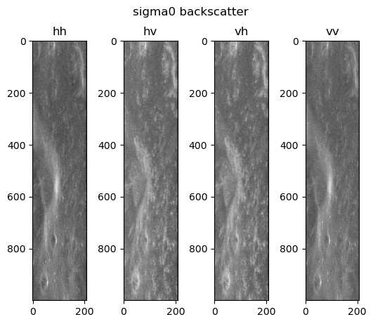
Fig. 1: A plot of four types of polarised radar backscatter of a small region of the Lunar South Pole, with a Gamma0 backscatter.
References:
[1] S. S. Bhiravarasu et al. (2021) Chandrayaan-2 Dual-frequency Synthetic Aperture Radar (DFSAR): Performance Characterization and Initial Results. Planet. Sci. J. 2 134
[2] J. Flahaut et al. (2019) Regions of Interest (ROI) for Future Exploration Missions to the Lunar South Pole. Planetary and Space Science, 180.
[3] E. Rignot (1995) Backscatter Model for the Unusual Radar Properties of the Greenland Ice Sheet. J Geophysical Res. 100 E5.
[4] G.J. Black et al. (2001) Icy Galilean Satellites: Modelling Radar Reflectives as a Coherent Backscatter Effect. Icarus. 151 2. P167-180.
How to cite: McVann, P., Ghail, R., Mason, P., and Manning, C.: The Creation of a Radiometric Correction Module in Python for Chandrayaan-2, Europlanet Science Congress 2024, Berlin, Germany, 8–13 Sep 2024, EPSC2024-622, https://doi.org/10.5194/epsc2024-622, 2024.