
Evolution of Titan’s labyrinths through chemical erosion and hillslope transport
 1,2,4,5,6,7,7
- 1European Space Agency (ESA), European Space Astronomy Centre (ESA/ESAC), Villanueva de la Canada, Spain (thomas.cornet@esa.int)
- 2Osuna, CNRS UAR 3281, Nantes Université, Nantes, France.
- 3LPG, Université d’Angers, Angers, France.
- 4Laboratoire GSMA, Université de Reims, Reims, France.
- 5LPG, Nantes Université, Nantes, France.
- 6Jet Propulsion Laboratory / California Institute of Technology, Pasadena, USA.
- 7IPGP, Université Paris-Diderot, Paris, France.
Introduction: First seen in the T39 Cassini RADAR SAR data in 2007, the high latitude labyrinth terrain on Titan consists in complex valleys that range from polygonal to linear features with morphological similarities with terrestrial karst landforms [1]. Karstic landforms on Earth are the product of several geological processes, among which the chemical erosion (dissolution) of fractured carbonates is the canonical example. On Titan, this analogy with karstic terrain is strengthened by theoretical predictions of the dissolution of some of Titan’s expected solid organics in liquid methane [2]. In this work, we test the hypothesis of labyrinths terrain being developed by dissolution-driven erosion. Simulated landscapes computed using a Landscape Evolution Model (LEM) including the dissolution process, and converted into Synthetic Aperture Radar (SAR) images, will be compared to the landforms visible in the Cassini RADAR SAR T39 images of the Sikun Labyrinthus area (Figure 1).
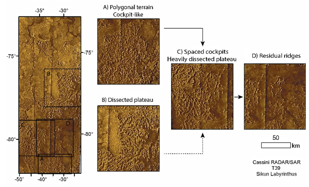
Figure 1: Sikun (B) - Ecaz (C) - Tupile (D) labyrinth area as seen from the T39 Cassini RADAR NLDSAR data [3], and possible evolution sequence between each landform.
Landscape simulations: We use the Channel-Hillslope Integrated Landscape Development (CHILD) Landscape Evolution Model (LEM) [4] to model the erosion and transport processes acting on a surface. This model was later modified to include the dissolution process as an additional factor of landscape evolution [5]. We use this version of the model in the present work.
The initial hexagonal mesh is defined as a 40 x 40 km planar surface with slight topographic changes of ±0.1m, with a spatial resolution of 100m. For each simulation, we fix a given set of geomorphic parameters, namely: the rate of erosion (via bulk dissolution), the hillslope diffusion rate, a sink density (designed to simulate pre-existing fracture networks), the topographic slope, and the elevation (thickness) of the layer being eroded. Erosion rates are derived from those computed for solids in pure liquid methane rains [2]. Additionally, we include simulations with a very low erosion rate as well to simulate an insoluble substratum. The hillslope transport coefficient is modified from terrestrial values to reflect the longer simulated timescales (1 Titan year = 29.5 Earth years). The initial surface elevation (~ layer thickness) is either 100m or 200m. The input precipitation scheme is inferred from climate simulations over a Titan year at the appropriate latitude [6]. The simulations are run out over geological timescales of 10 millions of Titan years.
SAR images reconstruction: The Cassini/RADAR SAR images are the highest resolution imagery data available (up to 300m/pixel), where labyrinths are resolved (Figure 1). In this work, we use their denoised version (NLDSAR) [3]. We compute synthetic SAR images based on the Digital Elevation Models (DEMs) generated with the LEM using a radar backscattering model (including both surface and volume scattering [7]), adapted to produce 2D images. We use the characteristics of the Cassini RADAR (f=13.78 GHz, l=2.18 cm), the dielectric properties of laboratory tholins [8], and surface albedo derived from previous studies [9], together with the look angle and altitude of Cassini during the T39 flyby for each DEM to generate a synthetic SAR image.
Results: Figure 2 shows the result of a simulation after 5 (top and middle) and 10 MTyr (bottom) using a dissolution coefficient of 10-6 (roughly one order of magnitude lower than organics in pure liquid methane [2]), a hillslope transport coefficient of 10-2 m/Tyr and 10 sinks per axis. In one scenario, aligned features tend to develop over sloped surfaces even in the absence of mechanical erosion (top). In contrast, ridges without preferential orientation tend to develop from surfaces without significant topographic slopes (middle, bottom), similar to the morphologies observed in the polygonal (Ecaz) to residual (Tupile) labyrinths (Figure 1). This could indicate that a 100 to 200 m thick layer of organics that has partly dissolved could produce the morphologies seen in Cassini SAR images of labyrinth terrains. Further work will include the statistical analysis of the modelled landscapes to infer possible quantitative information about Titan’s high latitude terrain properties.
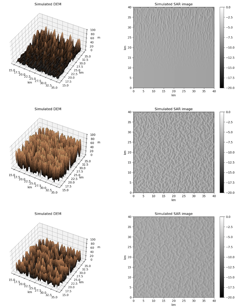
Figure 2: Examples of three simulated landscapes and their associated synthetic Cassini SAR images (illumination from the left, radar signal in dB) with the same landscape parameters. The topography shown corresponds to the central portion of the simulated DEM while the SAR images represent SAR simulations over the entire DEMs (40x40 km). Top panel: influence of an initial slope (Δh/d=0.0025), which leads to the development of linear features (time = 5 MTyr). Middle panel: simulation with a flat surface, where randomly oriented ridges and valleys develop (time = 5 MTyr). Bottom panel: previous simulation after 10 MTyr.
References
[1] Malaska M. et al. (2020), Icarus 344, 113764.
[2] Cornet T. et al. (2015), JGR Planets 120(6), 1044-1074.
[3] Lucas A. et al. (2014), JGR Planets 119(10), 2149-2166.
[4] Tucker G. et al. (2001), Computers Geosciences 27(8), 959-973.
[5] Fleurant C. et al. (2008), Geomorph., Rel., Proc., Envir. 1, 3-14.
[6] Liu J. and Schneider T. (2016), GRL 43(14), 7774-7780.
[7] Paillou P. et al. (2008), JGR Planets 111(E11).
[8] Paillou P. et al. (2016), Icarus 270, 211-221.
[9] Lucas A. et al. (2019), JGR Planets 124(11), 3140-3163.
How to cite: Cornet, T., Seignovert, B., Fleurant, C., Cordier, D., Bourgeois, O., Le Mouelic, S., Malaska, M., Lucas, A., and Rodriguez, S.: Evolution of Titan’s labyrinths through chemical erosion and hillslope transport, Europlanet Science Congress 2024, Berlin, Germany, 8–13 Sep 2024, EPSC2024-625, https://doi.org/10.5194/epsc2024-625, 2024.