The Fluvial and Volcanic History of Hebrus Valles and Hephaestus Fossae on Mars
- Lunar and Planetary Laboratory, University of Arizona, Tucson, United States of America (nerozzi@arizona.edu)
Introduction
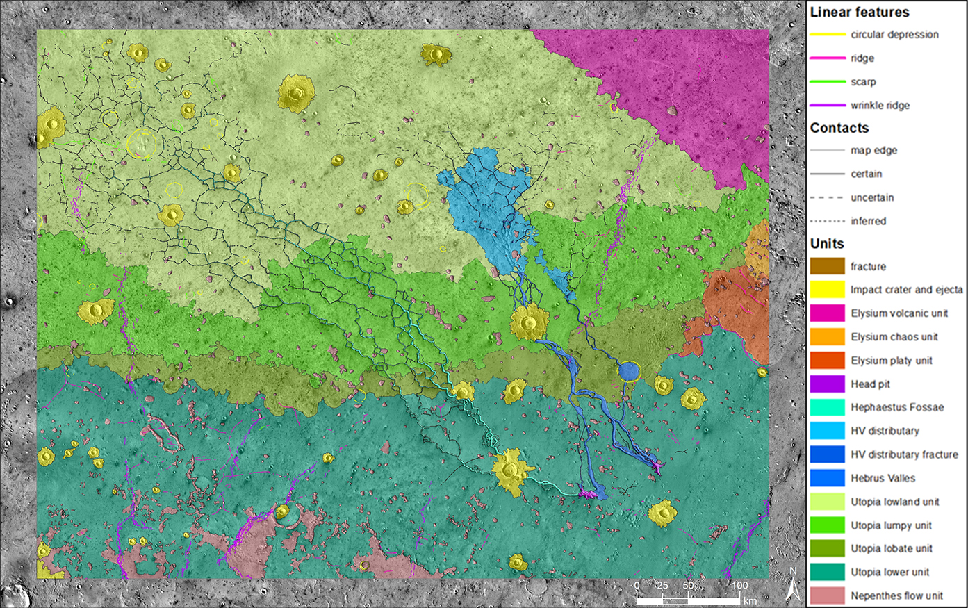
Hebrus Valles (HV) and Hephaestus Fossae (HF) are well-preserved Early Amazonian outflow channel systems carved into bedrock in SE Utopia Planitia, Mars (17-25 °N, 118-129 °E, Fig. 1). They exhibit a diverse set of morphologies indicative of formation by one or more liquid water outflow events (Christiansen, 1987; http://ntrs.nasa.gov/search.jsp?R=19870019962). However, little is known about their history, including both the origin and fate of the water and resulting sediments. This represents a significant gap in our understanding of geologic processes involving liquid water occurring in the Amazonian Period.
Thanks to extensive coverage by recent datasets, it is now feasible to study the evolution of the HV-HF outflow channel systems with an integrated analysis of diverse and complementary data, including high-resolution visible and infrared imagery mosaics. We performed chronostratigraphic geologic mapping of the HV-HF region followed by a detailed reconstruction of the sequence of geological processes and events based on the identification of morphological and thermophysical facies. Then, we employed impact crater statistical analysis to determine geologic unit and outflow channel ages.
Geologic mapping
The oldest unit in the study area is the Nepenthes flow unit, a complex layered volcanic and sedimentary unit that was previously identified in the adjacent Nepenthes Planum region (Skinner and Tanaka, 2018; doi:10.3133/sim3389). On top of it lies the Utopia lower unit, which also corresponds to a sedimentary unit identified older geologic maps (Tanaka, 2005; https://pubs.usgs.gov/sim/2005/2888/; Skinner and Tanaka, 2018; doi:10.3133/sim3389). Moving up in the stratigraphic column, we found three additional units: the Utopia lowland unit, the Utopia lumpy unit, and the Utopia lobate unit. Based on morphological facies analyses and the observation of clear and distinct stratigraphic contacts, we determined that the Utopia lumpy unit and the Utopia lobate unit originated from subsequent and distinct tsunami-like events (e.g., Rodriguez et al., 2022; doi:10.1038/s41598-022-18082-2) transporting sedimentary materials across Utopia Planitia. Instead, the Utopia lowland unit and the Utopia lumpy unit are not delimited by clear stratigraphic boundaries, suggesting that they may be different facies of the same chronostratigraphic unit. Three younger units overlie the Utopia units. In the NE corner of the geologic map lies the Elysium volcanic unit, which consists of volcanic flows related to Elysium Mons volcanic activity. To the south, we identified two additional volcanic and tectonic units: the Elysium platy unit and the Elysium chaos unit.

Figure 1: Chronostratigraphic map of the HV-HF region.
Age measurements
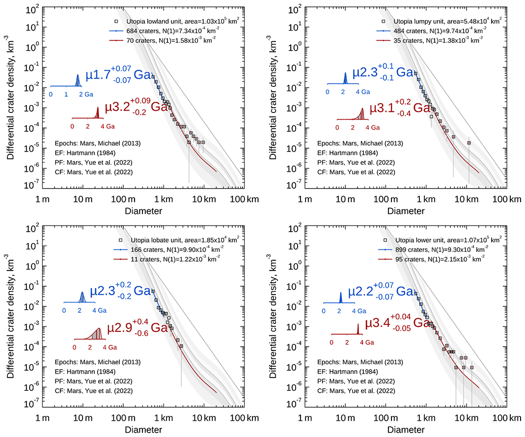
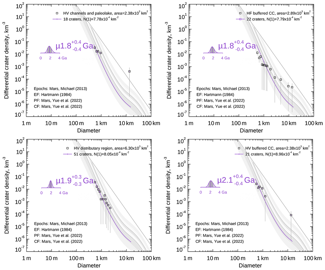
We conducted impact crater size-frequency distribution (CSFD) analyses on each chronostratigraphic unit by recording the locations and diameters of approximately 10000 impacts. We find formation ages for the Utopia units ranging from 2.9 Ga to 3.4 Ga (Fig. 2), placing the ages of units carved by channels between the Late Hesperian and Early Amazonian epochs. We also found evidence of resurfacing events occurring across three of the Utopia units at 2.2-2.3 Ga and a younger resurfacing event occurring at 1.7 Ga (Fig. 2). We interpret these events to be a combination of erosion of the Utopia Planitia plain-forming terrains and possible accumulation of volcanic sediments mantling the eastern half of the study area, perhaps associated with a peak in volcanic activity around 2-2.5 Ga (Platz and Michael, 2011; doi:10.1016/j.epsl.2011.10.001). Stratigraphy tells us that the Hephaestus Fossae and Hebrus Valles channel systems are necessarily younger than the surfaces they cut through, indicating that the channels must be younger than ~2.9 Ga. CSFDs within HV and in its distributary region yield ages of 1.8 Ga and 1.9 Ga, respectively (Fig. 3). Similarly, buffered crater counting of HV and HF yields ages of 2.1 Ga and 1.8 Ga, respectively (Fig. 3). These results confirm that the channels formed in the second half of the Early Amazonian about 1.5 Gy after the formation of the Utopia units, meaning that surficial aqueous activity in Utopia Planitia was occurring well into the Amazonian period.

Figure 2: CSFD analyses for the Utopia units with model formation ages (red) and resurfacing events (blue).

Figure 3: CSFD analyses for the HV and HF channels showing their model formation ages.
Origin and evolution of the outflow channels
The HV and HF channels originate from two deep pits within the Utopia lower unit (Fig. 1). We identified several elongated ridges protruding through the floor of these pits, which we interpret as remnants of magmatic intrusions that cracked the cryospheric seal of an ancient pressurized aquifer, as previously proposed for morphologically similar features in Cerberus Fossae (Head et al., 2003; doi:10.1029/2003GL017135). The morphology of the pits and the proximal sections of the channels are entirely compatible with morphologies observed in flume experiments where subsurface water discharge from a pressurized aquifer cause erosion and formation of terraces and deep source depressions within poorly consolidated sediments (Marra et al., 2014; doi:10.1002/2014JE004701). We reconstructed the initial phases of pit formation and channel incision in Fig. 4.
The pressurization of the aquifer can be explained by two mechanisms: heating of the aquifer by a magmatic intrusion that then cracked the cryospheric seal (Delaney, 1982; doi:10.1029/JB087iB09p07739) and/or the presence of an hydraulic gradient in an extensive cryospherically-sealed aquifer (e.g., Palumbo and Head, 2020; doi:10.1029/2020GL087230.). We find that both mechanisms could have contributed to the water discharge, and that the magnitude of their individual contributions depended on the permeability of the aquifer, because low permeability is required to maintain pressurization in the case of magmatic heating. We also note that the magmatic driver of pressurization and cryospheric cracking implies that the water release must have been modulated by magmatic activity, and thus we find it likely that multiple long-lived water discharge events occurred in this region until magmatic activity waned.

Figure 4: Step by step diagram of initial pit and channel formation. (left) A cryospheric seal confines a deep aquifer. Polygonal fractures are already present on the surface. (center) Magmatic intrusions crack the cryospheric seal leading to ponding of water, the formation of pits, and initial downslope flow on the surface. (right) Continuing water release deepens the source pits and carves channels in HV and HF, often following pre-existing fractures.
How to cite: Nerozzi, S., Spurling, R., and Holt, J.: The Fluvial and Volcanic History of Hebrus Valles and Hephaestus Fossae on Mars, Europlanet Science Congress 2024, Berlin, Germany, 8–13 Sep 2024, EPSC2024-648, https://doi.org/10.5194/epsc2024-648, 2024.