Mapping of Martian geomorphologies as a contribution to construct the first artificial analog in Colombia
- 1Universidad Nacional de Colombia, Bogotá, Colombia (laromerod@unal.edu.co)
- 2Constructor University, Bremen, Germany (jsuarezval@jacobs-university.de)
- 3Fundación Cydonia, Bogotá, Colombia (oscar6ojeda@gmail.com )
- 4Universidad Nacional de Colombia, Bogotá, Colombia (ynmendezc@unal.edu.co)
- 5Universidad Nacional de Colombia, Bogotá, Colombia (lhochoag@unal.edu.co)
1. Introduction
The development and validation of specific procedures for scientific activities in planetary analog sites, whether natural or artificial, are key to ensure the success, effectiveness, and safety in future extraterrestrial human exploration missions (Foucher et al. 2021). However, this has been developed in facilities and sites generally inaccessible for the Latin American scientific community and constitutes an obstacle for contributing to the study in analogs.
This work presents the geomorphological assessment of three representative landforms on Mars: a lava flow field at the southwestern base of Olympus Mons (13.18° N, 134.95 W), a lacustrine deposit in a paleolake within an impact crater near Maja Valles (5.33° N, 58.58° W) and the impact crater Catota in Acidalia Planitia (51.65° N, 25.98° W); which were used to test the analogy of morphological simulations of these landforms created in the first artificial Mars analog facility in Latin America, called "Rock Yard" within the Simulated Analog Space Exploration Habitat in Colombia (HAdEES-C).
2. Data
In order to carry out the geomorphological mapping and interpretation, images from the High Resolution Imaging Science Experiment (HiRISE), Mars Reconnaissance Orbiter (MRO) Context Camera (CTX) and the High Resolution Stereo Camera (HRSC) as well as digital terrain models available were collected and processed for each of the Mars’s sites, in addition to basemaps of Mars.
3. Results
3.1. Mapping of landforms
For each of the real sites on Mars, a geomorphological map was made and interpreted.
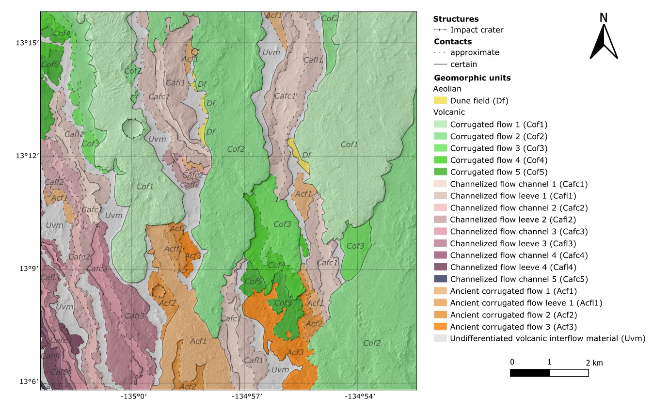
The area in the southernmost part at the base of Olympus Mons forms a flow field in an anastomosing network (Morris & Tanaka, 1995). Flows are broadly divided into three categories according to their morphology and stratigraphy (Peters et al. 2021). Corrugated flows (Cof) are the younger flows characterized for their rough surface texture resembling ‘a’a¯ flows in Hawaii (Hargitai & Kereszturi, 2015). Underlying are the Channelized flows (Caf), numerous and narrower flows with a smooth-textured central channel and rough-textured levees. And Ancient corrugated flows (Acf) are the oldest flows. These define at least three different episodes of volcanic activity with different emplacement styles. Figure 1 shows this map.
The possible paleolake is in a ~37 km complex impact crater and forms a closed-basin lake (Cabrol & Grin, 1999) with a >30 km long incised Inlet valley (Iv) (Goudge et al. 2015) but no outlet valley. It has an inlet continuous delta observed extending over 4 km, where different depositional events were identified based on the overlapping Deltaic slopes (Ds). The basin floor is nearly level given that the lacustrine deposits filled the topographic irregularities, but only resurfacing units are visible: Volcanic mantles (Vm) at east, and dark and finer Eolian deposits (Ed) at west.
The impact crater has a diameter of 1.3 km, is bowl-shaped and its rim is raised. The inner flank shows a Spur-and-gully (Sg) morphology (Watters et al. 2015) in the upper part and talus deposits in the lower part. The outer flank is covered by the preserved ejecta that divides in Continuous ejecta (Ec) and Discontinuous ejecta (Ed).

Figure 1: Geomorphological map of lava flows at the base of Olympus Mons.
3.2. Analogue model constructed
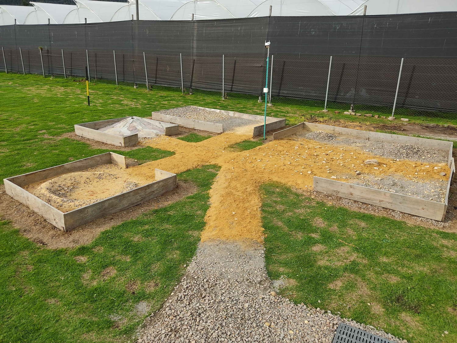
Following a low-cost and open science concept, the Rock Yard was built with two 4 m2, one 8 m2 and 18 m2 interconnected modules, each one with a specific landform made with easily accessible local construction materials to mechanically simulate the Martian soil. The cost did not exceed 400€ and it was built in 8 days. Figure 2 contains a photograph of the complete Rock Yard.

Figure 2: Rock Yard at HAdEES-C.
4. Discussions and conclusions
The recreated landforms represent approximately 44% of the Martian surface compared to the latest defined geological units on Mars defined by Tanaka et al. (2014). Several of the defined geomorphological units can indeed be correlated with the structures present in the simulations of the Rock Yard, and the main differences correspond to inconsistencies due to the scale, and the impossibility to recreate secondary surface processes on Mars that have modified the original landforms. Therefore, the Rock Yard constitutes a characterized facility whose main parameters are controlled with a geomorphologic analogy that is coherent within the limits of the scale of representation and the composition of the materials.
Work is currently underway to expand the area to include simulations of other landforms and generate interactions between them that represent a realistic geological history, to make this space a more rigorous scientific representation of the structures and processes on Mars. In any case, while being a first approximation to the design and construction of these facilities in Colombia, the Rock Yard is already a compact, representative, and accessible geologic analog. One that allows research, outreach, and educational activities that will contribute to the local production of scientific knowledge, and to bring the study of analogues to a wider public.
5. Acknowledgements
This project has received funding from Cydonia Foundation and GMAS and initiated as an undergraduate geology dissertation in the National University of Colombia.
6. References
- Cabrol, N., & Grin, E. (1999). Distribution, Classification, and Ages of Martian Impact Crater Lakes. Icarus, 142, 160–172.
- Foucher, F., Hickman-Lewis, K., Hutzler, A., Joy, K. H., Folco, L., Bridges, J. C., Wozniakiewicz, P., Martínez-Frías, J., Debaille, V., Zolensky, …, Westall, F. (2021). Definition and use of functional analogues in planetary exploration. Planetary and Space Science, 197.
- Goudge, T., Aureli, K., Head, J., Fassett, C., & Mustard, J. (2015). Classification and analysis of candidate impact crater-hosted closed-basin lakes on Mars. Icarus, 260, 346-367.
- Hargitai, H., & Kereszturi, Á. (2015). Encyclopedia of Planetary Landforms. Springer. doi:10.1007/978-1-4614-3134-3.
- Morris, E., & Tanaka, K. (1995). Geologic Maps of the Olympus Mons Region of Mars. USGS Astrogeology Science Center.
- Peters, S. I., Christensen, P. R., & Clarke, A. (2021). Lava Flow Eruption Conditions in the Tharsis Volcanic. Journal of Geophysical Research: Planets, 126.
- Watters, W., Geiger, L., Fendrock, M., & Gibson, R. (2015). Morphometry of small recent impact craters on Mars: Size and terrain dependence, short-term modification. J. Geophys. Res. Planets, 120, 226–254.
How to cite: Romero, L., Suarez, J., Ojeda, O., Mendez, Y., and Ochoa, L.: Mapping of Martian geomorphologies as a contribution to construct the first artificial analog in Colombia, Europlanet Science Congress 2024, Berlin, Germany, 8–13 Sep 2024, EPSC2024-695, https://doi.org/10.5194/epsc2024-695, 2024.