
 1,2,2,2,2,3,
- 1Insitute of Geodesy and Geoinformation Science, Technische Universität Berlin (TUB), Berlin, Germany (taruna.parihar@campus.tu-berlin.de)
- 2Institute of Planetary Research, German Aerospace Centre (DLR), Berlin, Germany
- 3Microwave and Radar Institute, German Aerospace Centre (DLR), Wessling, Germany
- 4Instituto Nacional de Pesquisas Espaciais (INPE), São Paulo, Brazil
Introduction
Saturn's moon Enceladus gained limelight with the discovery by the Cassini spacecraft of the plumes of ejected gas and ice particles from pronounced linear structures in its South Pole region called “Tiger Stripes". The small (504 km diameter) satellite is believed to have a porous rocky core and an ice shell, separated by a global subsurface saltwater ocean. The tidal heating potentially aids in driving chemical reactions in the moon’s interior which makes it a very promising candidate where the right conditions for life formation may exist. This makes Enceladus a prime target for a future mission. Due to strong gravitational perturbations caused by Saturn, the higher gravitational moments of Enceladus and additional perturbations by the other moons of Saturn, the dynamic environment for artificial satellites around Enceladus is extremely complex. As a consequence, the search for natural stable orbits is far from trivial. A polar orbit is desirable to further investigate the Tiger Stripes region, and for mapping of the global subsurface ocean.
Methodology
To calculate the spacecraft trajectories around Enceladus, all the relevant forces that are acting on the spacecraft are taken into account. We have used a numerical integrator which solves the general equation of motion of the spacecraft. Fig.1 depicts all the relevant perturbations, caused by the Sun, Jupiter, Saturn and its other moons, the higher degrees and order of Enceladus’ and Saturn’s gravity field and solar radiation pressure, which are taken into consideration. The drag experienced due to the plumes is considered negligible (Benedikter et al., 2022).
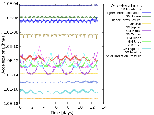
Fig.1. All the relevant accelerations experienced by the spacecraft in orbit around Enceladus at an altitude of 100 km from the surface.
Orbit Life Time Maps
We searched for suitable orbits in the inertial space by varying orbital parameters such as semi-major axis (350 to 450 km), inclination (40° to 120°), argument of periapsis and longitude of ascending node. The results are presented in the form of orbit life time maps. Fig.2 shows the orbit life time when we vary semi-major axis and inclination with respect to each other.
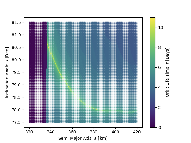
Fig.2 Orbit Life Time Map: The colour map shows the total life time of various orbits when Semi-Major Axis (320-420 km) and Inclination (77.5°-81.5°) are varied with respect to each other. The grid size of the map is 100 x 100.
Conclusions
Moderately inclined orbits (inclination between 45° and 60°) covering the equatorial and mid-latitude regions of Enceladus were found to be stable from several months up to years. In contrast, the more useful polar mapping orbits were found to be extremely unstable due to the so-called “Kozai mechanism”, due to which a spacecraft would impact the moon’s surface within a few days.
However, an example of a highly inclined orbit was found with inclination of approximately 79°, which had an orbital life time of approximately 13 days. A longer mission in this orbit would require correction maneuvers every few days. This would provide coverage of the tiger stripes region and allow for a global characterization of the ocean.
Orbit Control Strategy
We also determined the delta-v that would be necessary to maintain such an orbit over a mission of several months. This is a preliminary strategy which uses along-track manoeuvres only, i.e., accelerating or decelerating the spacecraft, to maximise the life time of the orbit. The budgets are assessed for an example reference semi-stable orbit solution and various correction manoeuvre frequencies, e.g., every 1, 2, and 4 days.
Also, special attention was paid to satellite formation flying in this orbit to maintain a stable baseline for a distributed radar sounder system (across-track formation of multiple satellites).
References
- Benedikter, A., et al. (2022) Acta Astronautica.
- Hussmann, H., et al. (2012) Planetary and Space Science.
- Ley, W., et al. (2009). Handbook of space technology.
- Enceladus, https://science.nasa.gov/saturn/moons/enceladus/
How to cite: Parihar, T., Hussmann, H., Wickhusen, K., Caritá, G., Stark, A., Oberst, J., Benedikter, A., Rodrigues Silva Filho, E., and Matar, J.: Numerical analysis of polar orbits for future Enceladus missions, Europlanet Science Congress 2024, Berlin, Germany, 8–13 Sep 2024, EPSC2024-707, https://doi.org/10.5194/epsc2024-707, 2024.