Oblique Impact Modelling of the Crater Formation and Icy Ejecta of the "Christmas Eve Crater" on Mars.
- 1Imperial College London, United Kingdom (n.wojcicka18@imperial.ac.uk)
- 2Institute for Earth and Space Exploration, University of Western Ontario, London, Canada
- 3U. S. Geological Survey, Astrogeology Science Center, Flagstaff, AZ, USA
- 4Brown University, Providence, RI, USA
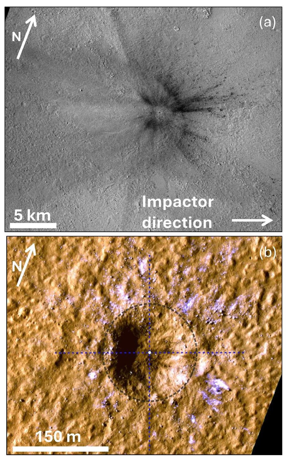
On the 24th of December 2021, an impact produced a 150-m-wide crater on Mars (Fig. 1) and excavated subsurface water ice [1, 2]. The crater is located at 35.10°N, 189.82°E in Amazonis Planitia, and is the largest crater observed to have formed since MRO (Mars Reconnaissance Orbiter) began observations in 2006. The crater presents the lowest-latitude observation of subsurface ice exposed by an impact on Mars [12]. The ice is seen in the proximal ejecta, <700 m from the crater rim, with the highest concentration much closer to the crater rim [2].
The impact produced a magnitude-4 seismic event detected by the InSight (Interior Exploration using Seismic Investigations, Geodesy and Heat Transport) lander, 3500 km away [1]. Here we compare observations with numerical impact simulations, to constrain impact parameters and target structure, specifically the location of the pre-existing subsurface ice. Our results will provide important constraints for the climate history on Mars and understanding the properties of impact-generated seismic waves.
Methods
We use iSALE3D shock physics code [3, 4] to simulate several scenarios that could have produced the “Christmas Eve crater”, informed by statistical analysis of impact parameters necessary to form a 150-m crater [1]. As asymmetry of the blast zone and the presence of an up-range ejecta exclusion zone suggest a highly oblique impact trajectory, we consider impact angles between 15–30°. We assume a spherical impactor of diameter 5–7 m striking the target at 12 km/s. We implement a two-layer target configuration. A fractured bedrock layer, modelled as 25% porous basalt (bulk density 2150 kg/m3), is overlain by a 50% porous basaltic regolith layer (bulk density 1430 kg/m3). Both layers are defined using the Tillotson equation of state for basalt [5], ϵ-α compaction model [6, 7] and the ROCK strength model [8]. We investigate three thicknesses of the upper layer: 10, 15 and 20 m, guided by observations of other craters in the area [2].
The state and position of ejecta are tracked using Lagrangian tracer particles throughout the simulation, and then projected to their final locations assuming ballistic trajectories [9]. We focus on the most proximal ejecta blanket, within 1 crater radius (75 m) of the crater rim, as it contains the highest concentration of visible ice. As we do not explicitly model ice as a separate material, we assume temperature and pressure thresholds of 0°C and 10 MPa, respectively, as the melting point and unconfined compressive strength of ice [10]. We identified ice patches visible around the crater using the quantitative multi-spectral method described in [11] to produce a map of icy ejecta for comparison with our simulations. We use this map to identify overlapping simulated ejecta particles and trace them back to their original positions, producing a possible pre-impact distribution of subsurface ice.
Results and Discussion
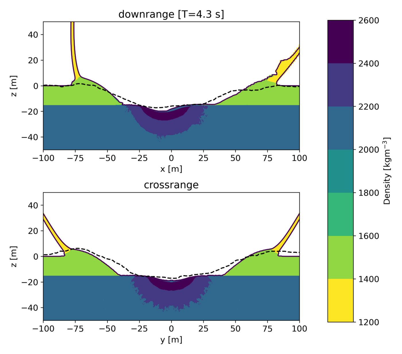
Our simulations produce craters with rim diameters of 130–160m, consistent with observations. The best match to the observed crater morphology is achieved by impacts into the 15-m-thick regolith layer. The simulated craters in this target configuration are 17–19 m deep (depending on impact angle, measured from the pre-impact surface), consistent with the observed crater (17 m), though have steeper walls. This could be explained by later-stage crater modification, which is not simulated here. Fig. 2 shows an impact scenario of a 5.2-m-wide impactor at 30°, compared with the observed crater profile.
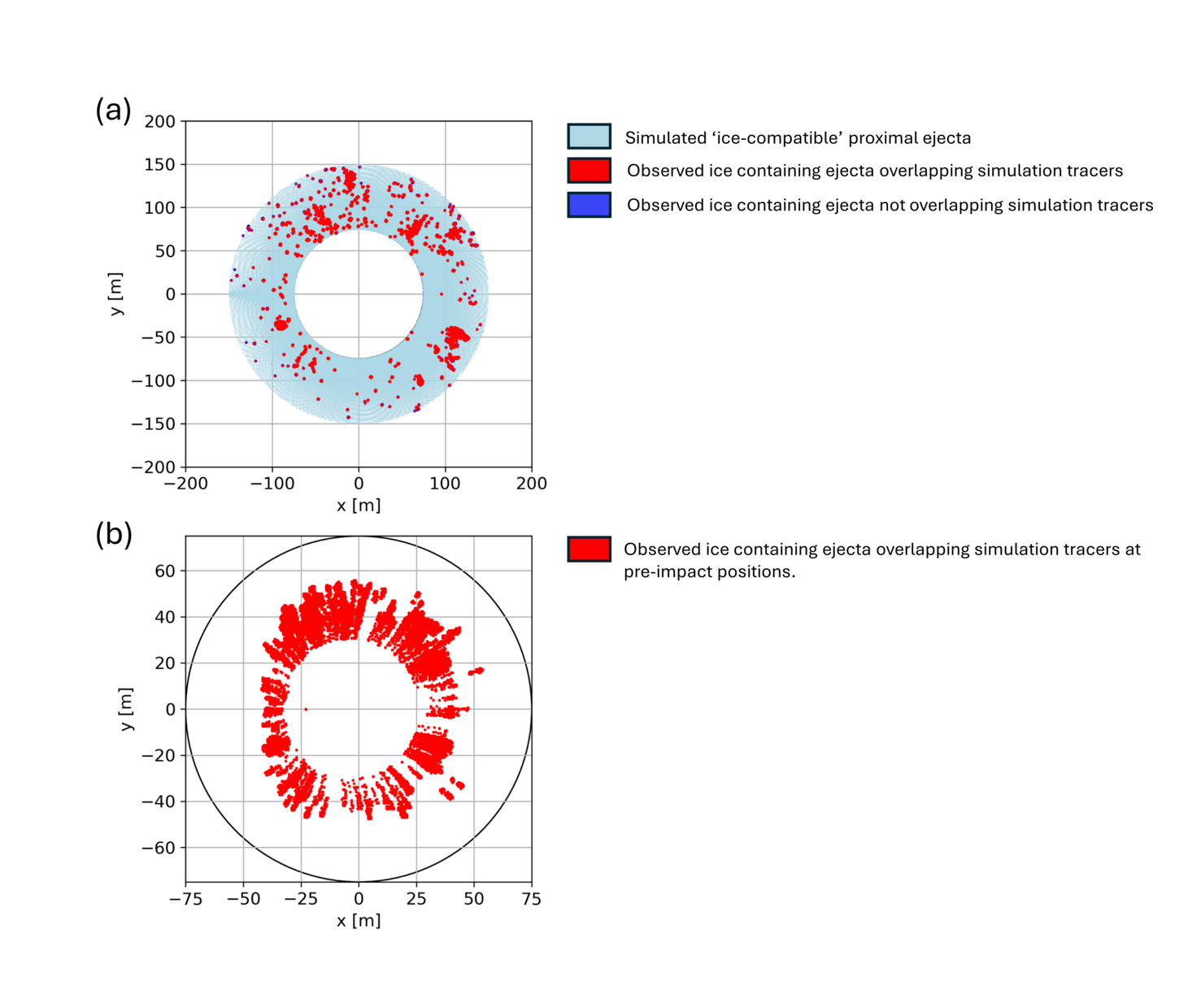
Our results suggest that the proximal ejecta blanket originated from depths <12 m. The ejecta that have experienced temperatures and pressures below the thresholds described above (‘ice-compatible’) originated from even shallower depths, <10 m, and from 30–60 m radially away from the crater centre (Fig. 3). No ejecta with preserved ice originates from closer to the crater centre owing to higher temperatures and pressures closer to the impact point.
For this scenario, 96% of ice-containing pixels overlapped with a simulation tracer particle. When projected to their pre-impact positions, the overlapping ejecta imply a discontinuous ice distribution under the pre-impact surface (Fig.3b), consistent with the heterogeneous distribution of subsurface ice found at other ice-exposing impact sites at higher latitudes [12].
Conclusions
Our iSALE3D simulation results suggest the presence of a stronger bedrock layer 15 m beneath the surface, overlain by a porous regolith layer. We find that the ice blocks visible in orbital images most likely originated from shallow depths <10 m. Our results also suggest that the ice was laterally discontinuous across the pre-impact target.

Figure 1: (a) CTX image of the Christmas Eve crater (image ID: K18_060561_2175_XI_37N170W). (b) HiRISE image of the crater and proximal ejecta (image ID: ESP_073077_2155_COLOR). Black circle marks the approximate crater rim. Dashed lines indicate the location of cross-sections in Fig. 2.

Figure 2: Depth profile of a simulation in (a) downrange and (b) cross-range direction, compared with the observed profiles (dashed lines) measured along the dashed lines in Fig. 1.

Figure 3: (a) Simulated ice-compatible ejecta at their final projected landing locations (light blue), the observed ice locations (dark blue squares) and observed ice pixels overlapping with simulated tracers (red). (b) Pre-impact locations of simulated ejecta overlapping with observed ice locations (red). Black circle marks the approximate crater rim.
References:
[1] Posiolova, L. V. et al. (2022) Science (New York, N.Y.) 378:412–417.
[2] Dundas, C. M. et al. (2023) Geophysical Research Letters, 50.
[3] Elbeshausen, D. et al. (2009) Icarus, 204:716–731.
[4] Elbeshausen, D. & Wünnemann, K. (2011) Proceedings, 11th Hypervelocity Impact Society Symposium.
[5] Tillotson, J. H. (1962) Report No. GA-3216, General Atomic, San Diego, CA,43.
[6] Wünnemann, K. et al. (2006) Icarus, 180:514–527.
[7] Collins, G. S. et al. (2011) International Journal ofImpact Engineering, 38:434–439.
[8] Collins, G. S. et al. (2004) Meteoritics and Planetary Science, 39:217–231.
[9] Raducan, S. D. et al. (2019) Icarus, 329:282–295.
[10] Durham, W. B. et al. (1983) Journal of Geophysical Research: Solid Earth, 88:B377–B392.
[11] Rangarajan, V. G. et al. (2023) Icarus,115849.
[12] Dundas, C. M. et al. (2021), Journal of Geophysical Research: Planets, 126(3), pp. 1–28.
How to cite: Wojcicka, N., Collins, G. S., Rangarajan, V. G., Dundas, C. M., and Daubar, I. J.: Oblique Impact Modelling of the Crater Formation and Icy Ejecta of the "Christmas Eve Crater" on Mars. , Europlanet Science Congress 2024, Berlin, Germany, 8–13 Sep 2024, EPSC2024-771, https://doi.org/10.5194/epsc2024-771, 2024.