Polyphase Amazonian floods in the Olympica – Jovis Fossae channel system.
- Centrum Badań Kosmicznych Polskiej Akademii Nauk (CBK PAN), Bartycka 18A, 00-716 Warszawa, Poland
- Centrum Badań Kosmicznych Polskiej Akademii Nauk (CBK PAN), Bartycka 18A, 00-716 Warszawa, Poland
Introduction
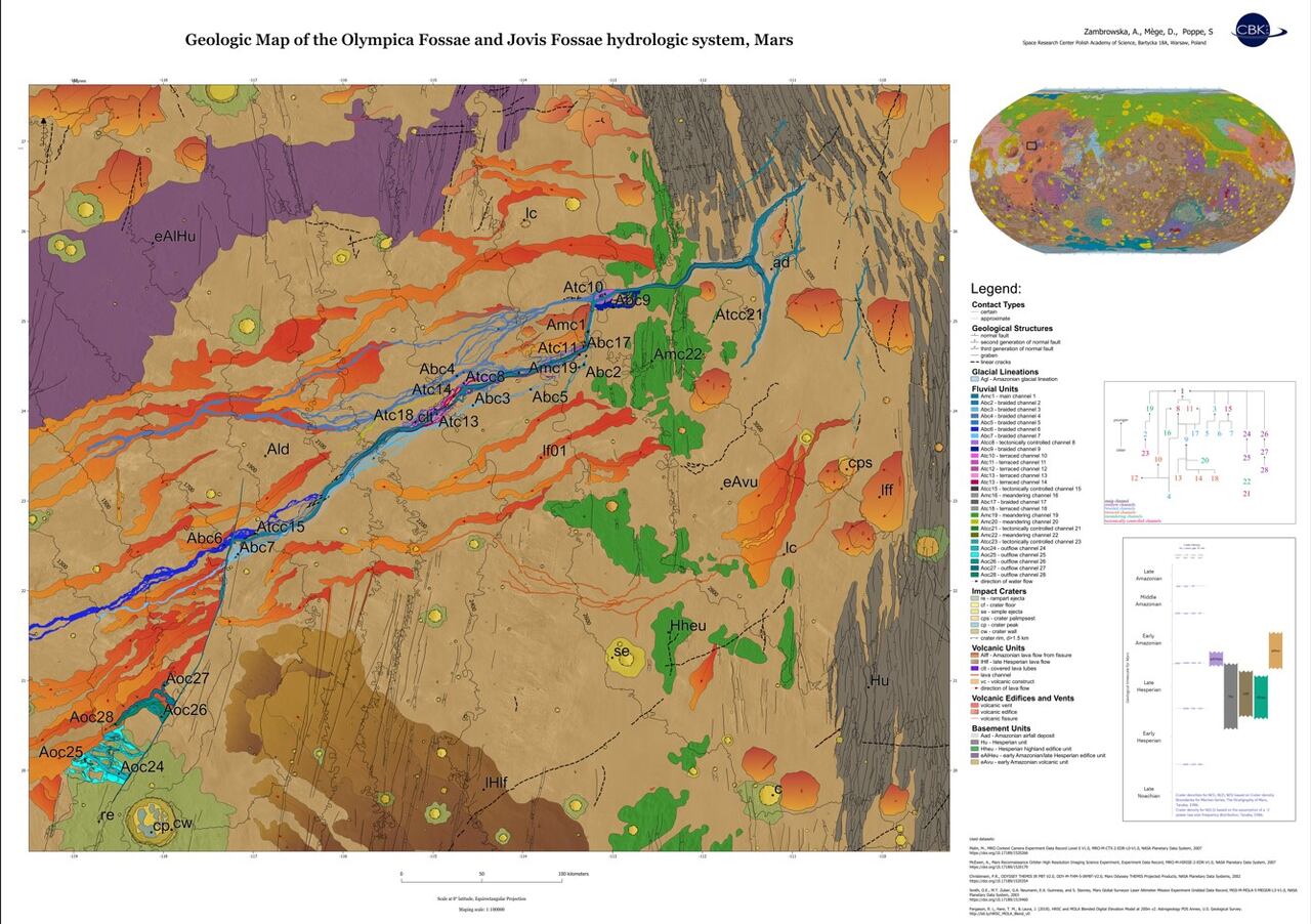
Geomorphological evidence of deglaciation was discovered on Mars at mid-latitudes [1, 2], in response to planetary obliquity changes [3]. Many craters contain evidence of subsurface ice remaining from Late Amazonian deglaciation [4]. Martian climate models predict the presence of ice accumulation in the mid-latitudes, especially on the western flanks of the Tharsis montes [5]. During the Amazonian epochs, the early Tharsis reservoirs were partly withdrawn to the surface, through outflow channels [6]. The largest of them formed between 3.7 and 3 billion years ago. There is evidence, however, that the crustal water reservoir was not exhausted after this time [7][8]. Many channels, including the largest Amazonian system Olympica – Jovis Fossae, formed at the top of the Tharsis bulge in lava flows that may be only a few hundred million years old [9]. To investigate the formation of such channel systems, we present a new geological map of Olympica-Jovis Fossae (Figure 1).
Data and methods
To map morphological and geological features, we used visible imagery from the Mars Reconnaissance Orbiter (MRO) Context Camera (CTX) with a resolution of 6 meters per pixel [10][11] and MRO High-Resolution Imaging Science Experiment (HiRISE) camera with a resolution of 25 cm per pixel [12]. To constrain the intersecting relationships between channels we used the newest DEM topography data (2021 – 2023) from the Mars Express High Resolution Stereo Camera (HRSC) with a resolution of ~20-40 meters per pixel [11][13] and optical imagery data from the ExoMars Trace Gas Orbiter, Colour and Stereo Surface Imaging System (CaSSIS) with a resolution of 4.8 meters per pixel ([14]).
Results
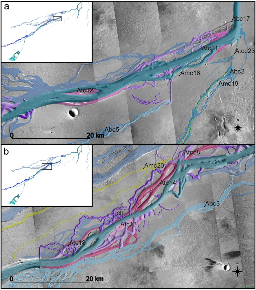
Our new geological map includes fluvial units (Figure 2), volcanic units, volcanic edifices and vents, glacial lineations, regional fracture systems, and impact craters. We identified 28 fluvial units that could be attributed to six classes, based on discriminating geomorphological features. Observed channel morphologies include the main channel (set of troughs and channels extending from the triple junction to Jovis Fossae), braided channels with densely interconnected channels with dendritic and sinuous geometry, terraced channels with eroded floors, step-like landforms, meandering channels, tectonically controlled channels, and outflow channels with streamlined islands. The oldest in the sequence of fluvial channels are terraced channels, representing multiple flooding events, followed by braided channels, meandering channels, outflow channels that originate at
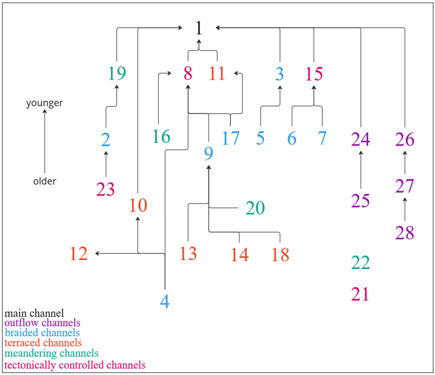
Jovis Fossae system fissures, and tectonically controlled channels (attributed to extensional stress, subsequently developed and filled by water and lava). Investigation of the mapped units and correlation of channel formation reveal at least three bigger flooding events. We determined the relative ages and relationships between fluvial channels from cross-cutting relationships (Figure 3).

Figure 1. Geologic map of the Olympica Fossae and Jovis Fossae hydrologic system.

Figure 2. Zoom on two regions of the map. Legend: clt – collapsed lava tube, Atc – Amazonian terraced channel, Amc – Amazonian meandering channel, Abc – Amazonian braided channel, Atcc – Amazonian tectonically controlled channel.

Figure 3. Chart of cross-section relationships between 28 fluvial channels. Arrowheads indicate younger flows.
Discussion and conclusion
We present the first detailed geological map and relative dating of the Olympica Fossae and Jovis Fossae, providing a basis for understanding the recent hydrologic and volcanic activity at the top of the Tharsis dome. Our map includes 28 individual fluvial units, glacial lineations, impact craters, volcanic units, edifices, and vents, as well as geological structures. We found a series of complex cross-cutting relationships between channels. General investigation of the channel’s morphology and their correlation with volcanic edifices reveal that the Olympica Fossae and Jovis Fossae formed by repeated overflows from various fissures related to an intensive period of distributed volcanism. Olympica – Jovis Fossae shares similar fluvial morphology with other outflow channels on Mars. Since our geologic map reveals six types of channels, future detailed morphologic analysis will be crucial to better understand the general conditions for catastrophic groundwater flooding in a volcanic context. Further efforts are needed to identify the chronological succession of deposition and flows and interfaces between floods, lava flows, and airfall deposits, based on crater retention age determination.
References:
[1] Baker, D. M. H., & Head, J. W. (2015). Icarus, 260, 269–288.
[2] Head, J. W., et al. (2006). Geophysical Research Letters, 33(8).
[3] Head, J. W., et al. (2006). Earth and Planetary Science Letters, 241(3-4), 663–671.
[4] Dickson, J.L., et al. (2010). Earth and Planetary Science Letters, 294(3-4), 332–342.
[5] Shean, D. E. (2005). Journal of Geophysical Research, 110(E5).
[6] Cassanelli, J.P., Head, J.W. (2019). Planetary and Space Science 169, 45-69.
[7] Rodriguez, J. A. P., et al. (2015). Icarus, 257, 387–395.
[8] Hiatt, E., et al. (2024). Icarus, 408, 115774
[9] Keske, A.L., et al. (2015). Icarus, 245, 333-347.
[10] Fergason, R. L., et al. (2021). 51st Lunar Planet. Sci. Conf. Abstract #2020.
[11] Jaumann, R., et al. (2007). Planetary and Space Science, 55(7), 928–952.
[12] McEwen, A. S., et al. (2007). Journal of Geophysical Research, 112(E5), E05S02.
[13] Neukum, G., Jaumann, R. (2004). Eur. Space Agency Spec. Publ., ESA-SP 1240, 17–35.
[14] Thomas, N., et al. (2017). Space Sci Rev 212, 1897–1944.
How to cite: Zambrowska, A., Mège, D., and Poppe, S.: Polyphase Amazonian floods in the Olympica – Jovis Fossae channel system., Europlanet Science Congress 2024, Berlin, Germany, 8–13 Sep 2024, EPSC2024-777, https://doi.org/10.5194/epsc2024-777, 2024.