
Computer vision model for monitoring mas wasting activity in the Martian North Polar region
 1,1
1,1- 1Deutsches Zentrum für Luft- und Raumfahrt (DLR), Planetengeodesie, Berlin, Germany (oleksii.martynchuk@dlr.de)
- 2TU Berlin
Introduction: The north polar region of Mars is one of the most active places of the planet with avalanches [1] and ice block falls [2] being observed every year on High Resolution Imaging Science Experiment (HiRISE) data. Both phenomena originate at the steep icy scarps, which exist on the interface between two adjacent geological units, the older and darker Basal Unit (BU) and the younger and brighter Planum Boreum 1 unit, which is a part of the so called North Polar Layered Deposits (NPLD). We are primarily interested in monitoring the current scarp erosion rate by tracking the deposition of ice debris at the foot of the polar cap. A similar analysis was already performed by Shu Se et. al [3], yet focusing only on the areas of the scarp where the ice fragments might have originated from. We strive to confirm the previous findings and establish an automated pipeline for continuous monitoring of the area throughout the entire MRO mission.
Methodology: Given the large scale of the region of interest, combined with a growing amount of available satellite data we believe that automation and optimization are key. To get from raw HiIRISE .JP2 products to clean ice block detections in approx. 10 min/image we propose the following routine:
- Gathering the data: Unfortunately not every image is equally valuable. We want to focus on the areas that were imaged over multiple years, as this allows us to continuously follow the evolution of polar ice. The filtering process can be automated by using python scripts and connecting directly to the PDS database.
- Scarp mapping with UNet: Since ice blocks accumulate at the bottom of the scarps, we only need to consider the portion of BU adjacent to NPLD. With a modified UNet [4] we can segment large HiRISE products and then use the resulting masks to derive precise scarp coordinates, extract only the relevant portions of the images & greatly reduce the computation times of the subsequent steps.
- Upscaling & sharpening with KernelGAN [5]: Large boulders are usually easy to identify due to their well differentiated visual features. As the blocks get smaller features become less pronounced and margins between different object instances shrink. We have experimentally established that cutting HiRISE products into tiles of 160x160 pixels and then upscaling them to 640x640 yields the best results when performing object detection.
- Co-registration: to perform change detection we need to co-register the images with pixel wise precision. Using DTMs creates additional complexity and can be avoided with the help of a purely image based method such as cv.findHomography.
- Object detection with YOLO: A slightly updated version of YOLO v5 that incorporates an additional fusion layer, residual connections and an attention module was used to perform object detection [6] (fig.1). With these modifications aimed at reducing the loss of the feature information of small objects we were able to achieve an mAP of 0.95.
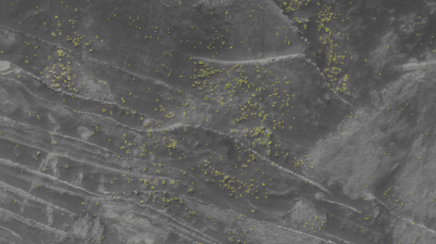
fig. 1 Multiple detections in an area with high mass wasting activity. Even the smallest instances are identified correctly.
Acknowledgments: All data for this investigation can be obtained at the HiRISE website (http://hirise.lpl.arizona.edu/) or the Planetary Data System (http://pds.nasa.gov).
References:
[1] Russell P., Thomas, N. Byrne, S. Herkenhoff, K.Fishbaugh, K. Bridges, N. Okubo, C. Milazzo, M. Daubar, I. Hansen. Seasonally active frost-dust avalanches on a north polar scarp of Mars captured by HiRISE, Geophys. Res. Lett. 35, L23204 (2008).
[2] L. Fanara, K. Gwinner, E. Hauber, J. Oberst. Present-day erosion rate of north polar scarps on Mars due to active mass wasting, Icarus, Volume 342, (2020),113434, ISSN 0019-1035.
[3] Shu Su, Lida Fanara, Haifeng Xiao , Ernst Hauber , and Jürgen Oberst. Detection of Detached Ice-fragments at Martian Polar Scarps Using a Convolutional Neural Network; ieee journal, vol. 16, 2023.
[4] Ronneberger, O., Fischer, P., & Brox, T. (2015). U-NET: Convolutional Networks for Biomedical Image Segmentation. arXiv (Cornell University). https://doi.org/10.48550/arxiv.1505.04597
[5] Sefi Bell-Kligler, Assaf Shocher, Michal Irani. Blind Super-Resolution Kernel Estimation using an Internal-GAN. arXiv:1909.06581
[6] Linlin Zhu, Xun Geng, Zheng Li and Chun Liu. Improving YOLO v5 with Attention Mechanism for Detecting Boulders from Planetary Images. Remote Sens. , 13(18), 3776 (2021).
How to cite: Martynchuk, O., Lida, F., Oberst, J., and Hussman, H.: Computer vision model for monitoring mas wasting activity in the Martian North Polar region, Europlanet Science Congress 2024, Berlin, Germany, 8–13 Sep 2024, EPSC2024-793, https://doi.org/10.5194/epsc2024-793, 2024.