
Geologic map of Tolstoj quadrangle (H08), Mercury
 1,1,1
1,1,1- 1INAF, IAPS, Rome, Italy (lorenza.giacomini@inaf.it)
- 2INAF, Osservatorio Astrofisico di Catania, Catania, Italy
- 3DISTAR, Università degli Studi di Napoli Federico II, Naples, Italy
Introduction: Tolstoj quadrangle is located in the equatorial area of Mercury, between 22.5°N and 22.5°S of latitude and 144° and 216°E of longitude. In this work we present the results of the geological mapping (1:3M scale) we performed using the high resolution basemaps of MESSENGER data.
Data: The main basemap used for the mapping is the MDIS (Mercury Dual Imaging System) 166 m/pixel BDR (map-projected Basemap reduced Data Record) monochrome mosaic compiled using NAC (Narrow Angle Camera) and WAC (Wide Angle Camera) 750 nm-images. In order to better distinguish the surface morphologies, MDIS mosaics illuminated with high solar incidence angle, both from east (HIE) and west (HIW) [1] have been considered. Moreover, to distinguish spectral characteristics and topography of the surface, MDIS global color mosaics [2] and the MDIS global DEM [3], have been taken into account. Since Tolstoj quadrangle is encompassed in the equatorial region, its map was produced in an equirectangular projection. Then, the quadrangle has been mapped using ArcGIS at an average scale of 1:400k for a final output of 1:3M.
Tolstoj quadrangle geological map: In H08 geological map geological contacts, lineaments, geological units, and surface features are shown (Fig.1). Geological contacts define the boundary of geologic units, that are surfaces characterized by the same morphology/texture, albedo/color characteristic, and stratigraphic position. Geological contacts are classified in: certain, where the contact is detected with confidence, and approximate, where the boundary between adjacent units is not well defined. Lineaments include: i) crater rims, distinguished between crater larger than 20 km and crater with a diameter ranging between 5 and 20 km, ii) tectonic structures, subdivided in grabens, wrinkle ridges, and thrusts, iii) pit rims, representing the crest of irregular pits that are interpreted to be volcanic vents. Surface features are grouped in crater chains and clusters, hollows and faculae (i.e. pyroclastic material).
The final geological map shows the Caloris basin-related features dominating the most part of Tolstoj quadrangle. Indeed, the southern half of the basin is located in the upper left corner of quadrangle. Consequently, several units related to basin rim and ejecta material have been mapped (i.e. Odin, Van Eyck, Nervo, and Caloris Montes Formation). Moreover, smooth plains emplaced within and all around Caloris basin are the most extended volcanic deposits emplaced in H08. Intercrater plains are instead confined in the south-eastern margin of the quadrangle.
Also structural framework is mainly linked with the basin with radial and concentric grabens located in its floor. These structures formed in response of extensive stresses due to the later stage of deformation of Caloris inner smooth plains [4]. Wrinkle ridges appear as low relief arches with a narrow superposed ridges. They are widespread on the Caloris smooth plains and their origin are attributed mainly to compressional stresses due to the subsidence of plains material [5]. In the inner smooth plains they show a preferential concentric and radial orientation with respect to the Caloris basin center; whereas the orientation of outer smooth plains’ wrinkle ridges does not show a strong correlation with the basin. Also thrusts, that are low-angle inverse faults, have been mapped. They are located outside the Caloris basin but they are absent within its floor. Their origin are likely correlated to the planet contraction.
Besides smooth plains, products of effusive volcanism, features related to explosive volcanism are also frequently detected. Interestingly, several volcanic vents have been identified in the inner Caloris smooth plains, aligned with the basin rim. They were surrounded by extended pyroclastic deposits appearing in bright yellow in MDIS enhanced global color mosaics. However, vents are not clustered only inside Caloris basin, but other crater floors are affected by this type of features.
Finally, fields of hollows, small rimless depressions whose origin is related to volatiles loss [6], are detected. However, in Tolstoj quadrangle they are quite rare and are mainly located within the crater floor.
Conclusions: In this work we presented the main characteristics of Tolstoj quadrangle geological map, dominated by the Caloris basin related features. This map will be merged with the other mapped quadrangles [7-14] and integrated into the global 1:3M geological map of Mercury [15], which is being prepared in support to ESA/JAXA (European Space Agency, Japan Aerospace Agency) BepiColombo mission.
References: [1] Chabot et al.:LPS XLVII. Abstract#1256, 2016. [2] Denevi et al.:LPS XLVII. Abstract#1264, 2016.[3] Becker K. J., et al. AGU, Fall Meeting, abstract#P21A-1189, 2009.[4] Watters et al.:. Earth Planet. Sci. Lett.285, 283–296, 2009.
[5] Watters and Nimmo: In: R.A. Schultz and T.R. Watters, eds., Planetary Tectonics, Cambridge Univ Press, 15- 80, 2010. [6] Blewett et al., JGR, 121, 1798-1813. [7] Galluzzi et al.: Geology, J. Maps, 12, 226–238, 2016.[8] Mancinelli, P. et al.: Journal of Maps, 12, 190–202, 2016. [9] Guzzetta L. et al.: Journal of Maps, 13, 227–238, 2017.[10] Wright J. et al.: Journal of Maps, 15, 509-520, 2019.[11] Pegg D. L.. et al.:. Journal of Maps, 17:2, 859-870, 2021.[12] Giacomini et al.: Journal of Maps, 18, 2022. [13] Malliband C. C., et al.: Journal of Maps, 19, 2023. [14] Man B. et al., Journal of Maps, 19, 2023. [15] Galluzzi V. et al.: Mercury 2024, abstract, 2024.
Acknowledgements: We gratefully acknowledge funding from the Italian Space Agency (ASI) under ASI-INAF agreement 2017-47-H.0
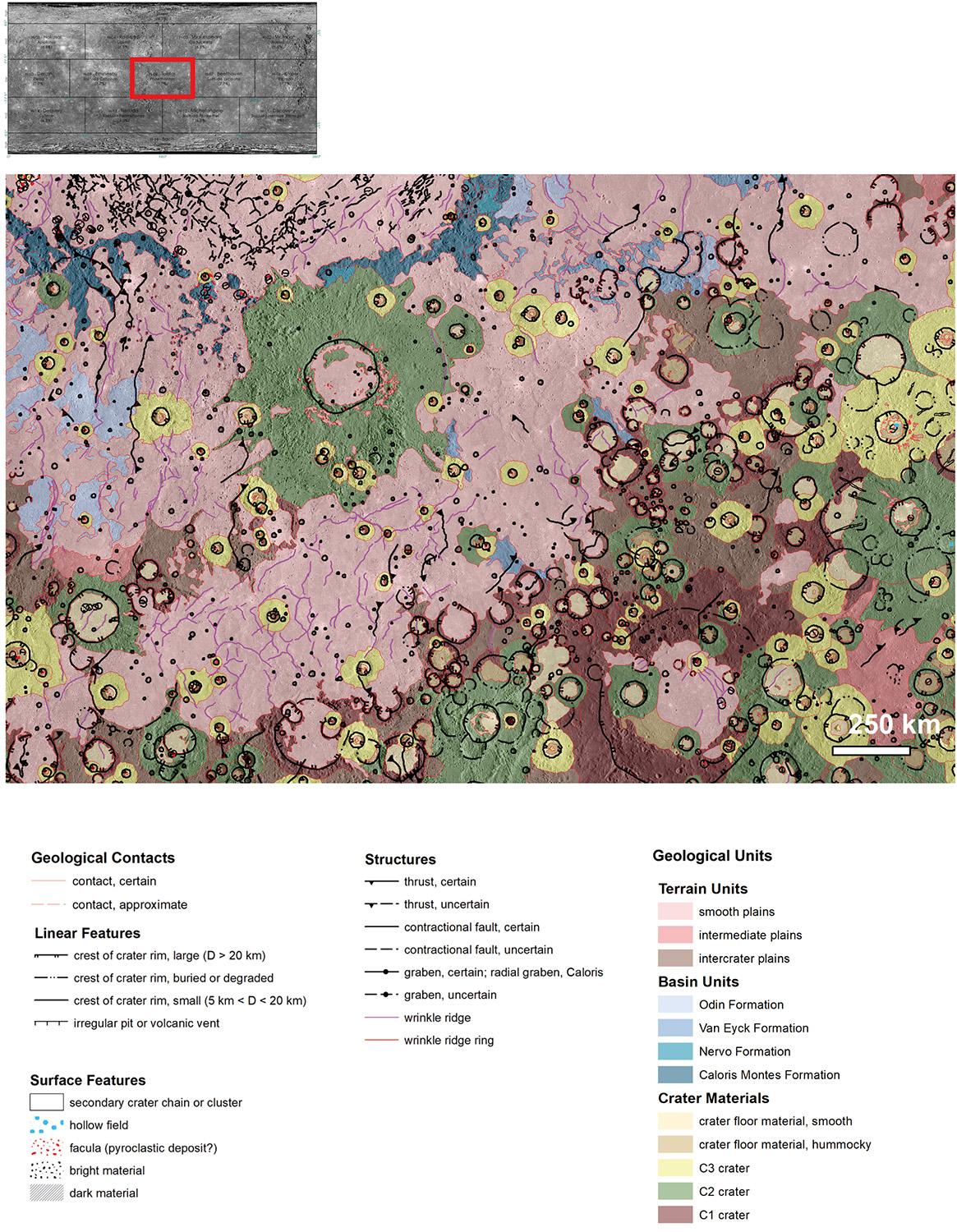
Fig.1 Geological map of Tolstoj quadrangle (H08)
How to cite: Giacomini, L., Guzzetta, L., Galluzzi, V., Ferranti, L., and Palumbo, P.: Geologic map of Tolstoj quadrangle (H08), Mercury, Europlanet Science Congress 2024, Berlin, Germany, 8–13 Sep 2024, EPSC2024-797, https://doi.org/10.5194/epsc2024-797, 2024.