
 1,2,4
1,2,4- 1IAS, Paris-Saclay Univ., Orsay , France (john.carter@ias.u-psud.fr)
- 2LAM, Aix-Marseille Univ., Marseille, France (john.carter@lam.fr)
- 3LPG, Nantes Univ., Nantes, France (Veronique.Ansan@univ-nantes.fr)
- 4LPG, Nantes Univ., Nantes, France (Nicolas.Mangold@univ-nantes.fr)
Introduction: Hellas Planitia is the largest and deepest preserved impact basin on Mars. It was likely in place by the Early Noachian and has since undergone a complex geologic history with km-thick infillings and similar magnitudes of erosion [1]. As a deep basin, Hellas must have played an important role within the Noachian hydrological system(s), regardless of if these were long or short-lived, continuous or intermittent [e.g. 2,3]. There are a number of conspicuous morphological and mineralogical clues within or around Hellas which suggest past aqueous activity. In particular, its outer rim features phyllosilicates in layered (likely sedimentary) deposits [4,5]. There is also evidence for at least ephemeral flow of water, as evidenced by regionally extensive silcrete deposits [6-9]. Yet there is no evidence for past ponding within Hellas.
Method: To better understand the role of Hellas within past hydrological systems, we conducted a systematic survey of the mineralogy and morphology. Mineralogy is obtained through orbital remote sensing with the OMEGA/Mars Express and CRISM/MRO instruments. Most observations did not yield meaningful surface composition data, owing to the increased atmospheric opacity of Hellas, its frequent hazes and frosts. We focused our study on the most eroded western part of Hellas which exhibits terrains of a large range of ages.
Results: The resulting mineral mapping is shown in figure 1 (MOCAAS database [10] https://www.ias.u-psud.fr/moccas). Three distinct mineral units are distinguishable: 1) Fe/Mg phyllosilicate sediments (red) just outside of Hellas, 2) opal CT/chalcedony silcretes (cyan) on the intermediate margin of Hellas, 3) a previously unknown sulfate-rich floor unit (green). The patchy nature of the mineral maps within Hellas is a detection bias as they are only few valid observations, and signal-to-noise levels are generally lower than the rest of Mars. A conservative mapping approach was chosen here.
We focus on the sulfate unit of the floor of Hellas, which is mostly exposed on its western side. The striking feature of these salts is that they correlate with a small set of morphological units, and that they are found in the deepest exposed sections of Hellas Planitia (currently mapped between - 6500 and -7500 m, mostly below -7000 m). As such they are likely not related to polar sulfates which are known to have formed (or still form) at high southern latitudes [11].
The precise composition of the salt hasn’t been ascertained yet, but it is most likely a poly-hydrated sulfate, which spectra are similar to salt deposits of the Terby crater floor, but is not unique to these sites. The 1.9 µm band shape is generally inconsistent with gypsum but may include bassanite. The spectra do not exclude hydrated chlorinated salts [12,13]. The salt detections are correlated primarily to the so-called “honeycomb” terrains, and to a lesser degree to the “banded” terrains (figure 2). Previous terrain designation also included “reticulate” terrains [12-14].
Discussion: A recurring interpretation of the honeycomb terrains are that they diapirs which topmost section has been eroded away, exposing the truncated cells [e.g.17-19]. The banded terrains are at times equated to the honeycomb terrains or considered to be a different unit. The formation of diapirs is related to the presence of layers of different densities, the lighter material being buried below a dense material such as lava flows. The diapiric material has been proposed to be either salt or ice [e.g. 19] but direct compositional evidence was lacking to distinguish between both scenarios. We therefore propose that these were indeed salt diapirs. The salty nature and cell size of the diapiric terrains of Hellas Planitia suggest ~2 km of salts existed on the basin floor [e.g. [19], only exposed where erosion most deeply incised the overlying material.
One consequence is that this observation may help solve the conundrum of the missing salts on early Mars [20]. As the Noachian highland terrains were leached and formed phyllosilicates, if sulfates were the cation host, it may indicate the climate at least intermittently allowed a mature hydrological system wherein salts would be transported in dissolved fraction over large distances from source to sink, and accumulate in sedimentary basins - most notably Hellas.
Concerning Hellas Planitia specifically, this detection suggests that Hellas has had one or several episodes during which it was filled by water. Kieserite (mono-hydrated sulfate) is relatively dense and would preclude the formation of diapir cells but poly-hydrated salts are light enough to enable diapirs [19], consistent with the CRISM and OMEGA spectra. Chlorinated salts are also light enough and cannot be excluded from the spectra at this point, either as an alternative to the sulfate, or perhaps as an assemblage which cannot be directly detected (especially in dehydrated form).
Further investigations of the extent of the sulfate unit is required to understand both the altitude range and lateral extent of the salt diapirs, which will strongly affect the size of the sea and the cumulative GEL of water required to deposit the salts. Recent estimates range from a sea a few 100s m deep to over 1 km [17], but previous studies proposed Hellas was filled well above these values [4]. The exact sulfate composition will also be refined.

Figure 1 . Western Hellas Planitia aqueous mineralogy based on OMEGA and CRISM. Red: Fe/Mg phyllosilicates. Cyan: hydrated silica. Green: poly hydrated sulfates.
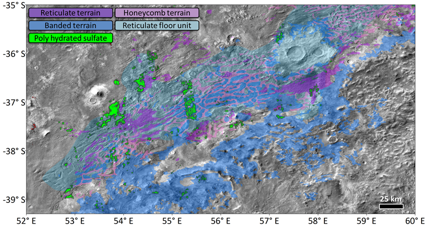
Figure 2. Close up on the sulfate-rich diapirs of Hellas. Geological units from [14,16].
References: [1] Tanaka+95, JGR, 100, 5407-5432. [2] Andrews-Hanna+11, JGR, 116, E02007. [3] Hiatt+24, Icarus, 408, 115774. [4] Wilson+07, JGR, 112, E08009. [5] Ansan+11, Icarus, 211, 273-304. [6] Bibring+06, Science, 312, 400. [7] Bandfield+08, GRL, 35, L12205. [8] Carter+13, JGR, 118, 831–858. [9] Pineau+23, LPSC 54th, abstract #1982. [10] Carter+23, Icarus, 389, 115164. [11] Barraud+22, EPSC 16th, abstract #847. [12] Hanley+13, JGR, 20, 1415–1426. [13] Bishop+14, LPSC 45th, abstract #2145. [14] Leonard+01, USGS Spec. Pub., doi. 10.3133/i2694. [15] Bernhardt+16, Icarus, 264, 407-442. [16] Bernhardt+19, Icarus, 321, 171-188. [17] Mangold+03, 6th Int. Conf. Mars, Abstract #3047. [18] Bernhardt+16, JGR, 121, 714-738. [19] Weiss+17, Icarus, 284, 249 -263. [20] Millliken+09, GRL, 36, L11202.
How to cite: Carter, J., Ansan, V., and Mangold, N.: Was Hellas Planitia a Noachian Sea?, Europlanet Science Congress 2024, Berlin, Germany, 8–13 Sep 2024, EPSC2024-802, https://doi.org/10.5194/epsc2024-802, 2024.