
 1,3,1,7,8,9,12,11,
- 1The Open University, School of Physical Sciences, Milton Keynes, United Kingdom of Great Britain – England, Scotland, Wales (peter.fawdon@open.ac.uk)
- 2European Space Research and Technology Centre (ESA/ESTEC), Directorate of Human and Robotic Exploration, Keplerlaan 1, 2201 AZ Noordwijk, The Netherlands,
- 3Institute of Planetary Science, German Aerospace Center (DLR), Berlin, Germany
- 4Jet Propulsion Laboratory, California Institute of Technology, 4800 Oak Grove Drive, Pasadena, CA, 91109, USA
- 5Department of Earth Sciences, Imperial college London, Cromwell Road, Kensington, London, SW7 5BD, UK
- 6Istituto di Astrofisica e Planetologia Spaziali, Istituto Nazionale di Astrofisica, via del Fosso del Cavaliere, 100, I-00133 Rome, Italy
- 7Department of Earth Sciences, Natural History Museum, London, United Kingdom
- 8German Aerospace Center (DLR), Institute of Planetary Research Rutherfordstr. 2, 12489 Berlin
- 9Nantes Université, Univ Angers, Le Mans Université, CNRS, Laboratoire de Planétologie et Géosciences, LPG UMR 6112, 44000 Nantes, France
- 10Université Paris Saclay - CNRS - Institute d'Astrophysique Spatiale, 91405 Orsay, France
- 11Univ Lyon, Univ Lyon 1, ENSL, CNRS, LGL-TPE, Villeurbanne F-69622, France
- 12Physikalisches Institut, University of Bern, Sidlerstrasse 5, 3012, Bern, Switzerland
- *A full list of authors appears at the end of the abstract
Introduction: Oxia Planum (OP) [1] is the selected landing site for the ExoMars Rosalind Franklin (RF) Rover. The goal of the reformulated ExoMars Rosalind Franklin mission, now in planning for launch in 2028, is to search for signs of past and present life and to characterize the water and geochemical environment in the subsurface as a function of depth. RF will accomplish this with its ‘Pasteur’ suite of scientific instruments, and a drilling and sampling subsystem to retrieve samples for analysis from up to 2 m depth [2].
In preparation for the 2022 mission, The ExoMars science team undertook a geological mapping exercise of the landing site [3] prioritizing the 1-sigma area of the 2022 landing ellipses (Fig 1). The goal of this map is to develop a thorough understanding prior to rover operations of the OP landing site’s geography, stratigraphy, and geological history, and to provide testable hypotheses to facilitate interpretation of results and address the mission’s science objectives.
Here we present the completed map of Oxia Planum, our interpretations of the major geological units, the leading hypotheses for some major units and implications for astrobiology goals of the mission.
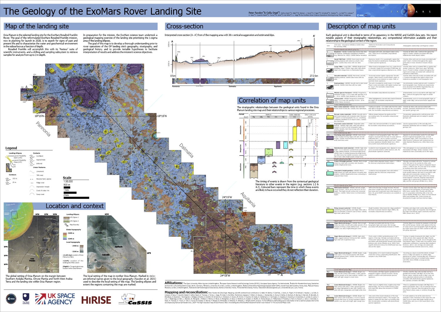
Figure 1: The compleated map sheet of the 1:25,000 scale landing site map (https://www.tandfonline.com/doi/full/10.1080/17445647.2024.2302361 )
Progress: The compleat map (Figuer 1) is presented at a scale of 1:30,000 and includes 14 bedrock geological units in 6 groups, 6 overlay units and geomorphic linework.
Interpretations and Hypotheses: This map is a detailed investigation into geological units of the proposed landing site; however these units are also representative of the wider Oxia Planum region. To formulate interpretation and hypothesis we incorporate these additional contextual observations and consider a range of possible interpretations and associated confidences presented in [4].
Lower bedrock group (lBg; lBg1, lBg 2, lBg3) –materials with orange tone CaSSIS Near IR Panchromatic Blue channel images strongly associated with phyllosilicate spectral signatures. Also includes brighter ‘knobby’ materials, whether these are stratigraphically distinct layers or lateral variation is unclear. Contextual observation suggests the origin of these units may be the upper part of a lacustrine to alluvial succession [5] but it is also likely that the alteration predominantly occurred in situ [6, 7].
Upper Bedrock group (uBg; uBg1, uBg2, uBg3) – uBg1 forms a thin resistant layer directly underlying Mm and oDm units. uBg2 and uBg3 host a boxwork of upstanding ridges associated with high relief areas such as scarps and large ridges. Regionally extensive, this unit crops out as a mantling layer, and contains exhumed fluvial channel bodies, so an origin related to fluvial and groundwater processes is possible, but this may be reworking of widespread volcanoclastic material.
Mound material (Mm; hMm, rMm) – This unit group constitutes isolated hills (hMm) and ridges (rMm), which are part of a regional population. Mm predates the dark group and appears to be remnants of a ~100 m thick layer [8]. However, deposition and erosion mechanics for the unit are unresolved.
Dark material (Dm; oDm iDm) – Thin (~1 m), rough units with lots of trapped regolith, are found at the top of the stratigraphy (oDm) on local topographic highs in regional topographic lows, or interbedded with the lBg
Bright patches (Bp; cfBp, cBp) – Light toned patches with concentric layers occur in (<100m) relic impact structures or larger (>250m), but not infilled, craters.
Crater materials (Cm; nCM, rCm, dCm) – Material relating to impact craters show degradation states varying from fresh dark ejecta (nCm) to degraded and overlain rims (dCm).
Conclusions: The mapping effort is now completed. Since the resumption of the ExoMars mission we are working towards publication of the map, data and accompanying report to support science activities in preparation for the planned 2028 launch.
Acknowledgments: We thank the CaSSIS and HiRISE teams for ongoing data collection. PF thanks UK Space Agency for funding (ST/W002736/1)
References: [1] Fawdon, et al (2021) Journal of Maps, 17:2, 621-637, [2] Vago, J. et al., (2017) Astrobiology 17 (6–7), 471–510. [3] Sefton-Nash, E. et al., (2021) in LPSC 51, Abs.# 1947. [4] Fawdon P. in LPSC54 abs#2061 [5] Fawdon et al., 2022 JGRp 127, e2021JE007045 [6] Mandon et al, 2022 Astrobiology 2021 21:4, 464-480 [7] McNeil et al, LPSC54 abs#1252 [8] McNeil et al 2022 JGRp 127, e2022JE007246
F. Altieri, A. Apuzzo, J. Aramendia, G. Arana, R. Bahia, S. Banham, R. Barnes, A. Barrett, W. Benedix, A. Bhardwaj, S. Boazman, T. Bontognali, J. Bridges, B. Bultel, V. Ciarletti, M. De Sanctis, Z. Dickeson, E. Favaro, M. Ferrari, F. Foucher, W. Goetz, A. Haldemann, E. Harrington, A. Kapatza, D. Koschny, A. Krzesinska, A. Le Gall, S. Lewis, T. Lim, J. Madariaga, B. Man, L. Mandon, N. Mangold, J. McNeil, A. Molina, A. Moral, S. Motaghian, A. Nass, S. Nikiforov, N. Oudart, A. Pacifici, A. Parkes Bowen, D. Plettemeier, P. Poulakis, A. Putri, O. Ruesch, L. Sam, C. Schröder, C. Statz, R. Thomas, D. Tirsch, Z. Toth, S. Turner, M. Voelker, S. Werner, F. Westall, B. Whiteside, A. Williams, R. Williams, J. Wright, M. Zorzano,
How to cite: Fawdon, P., Orgel, C., Adeli, S., Balme, M., Calef, F., Davis, J., Frigeri, A., Grindrod, P., Hauber, E., Le Deit, L., Loizeau, D., Nass, A., Quantin-Nataf, C., Sefton-Nash, E., Thomas, N., Torres, I., Vago, J., Volat, M., and De Witte, S. and the ExoMars RSOWG 'macro' Mapping team: The high-resolution map of Oxia Planum, Mars; the landing site of the ExoMars Rosalind Franklin rover mission, Europlanet Science Congress 2024, Berlin, Germany, 8–13 Sep 2024, EPSC2024-850, https://doi.org/10.5194/epsc2024-850, 2024.