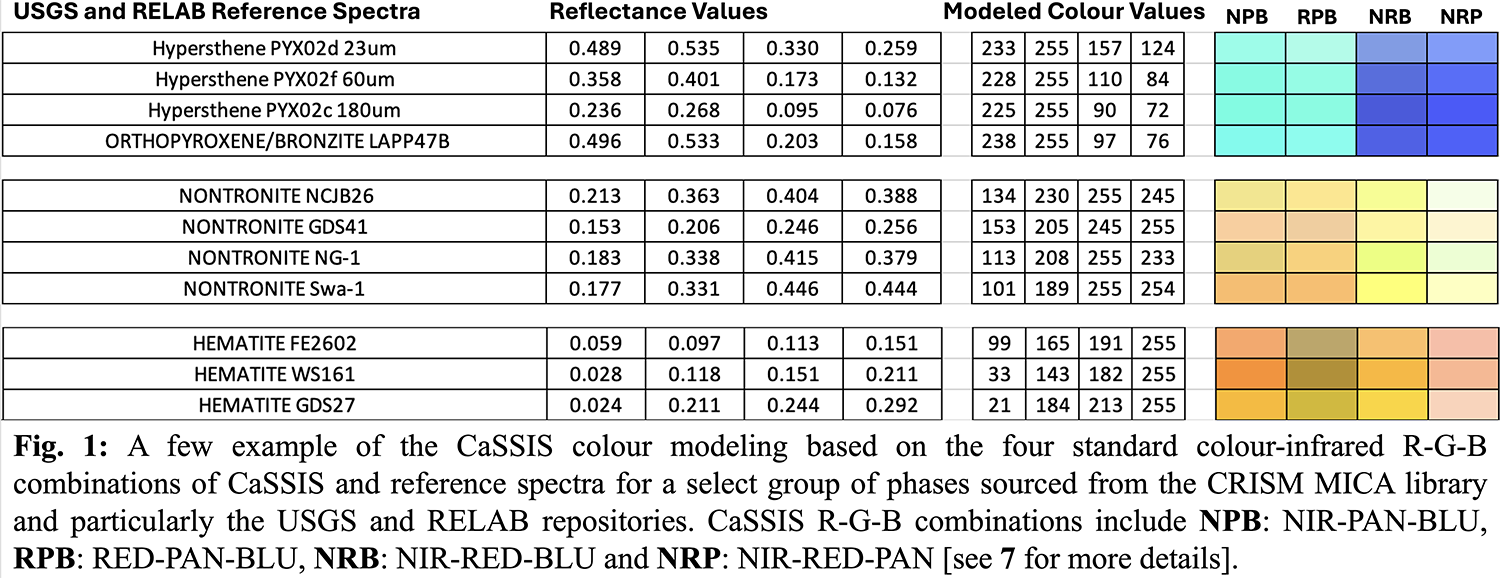
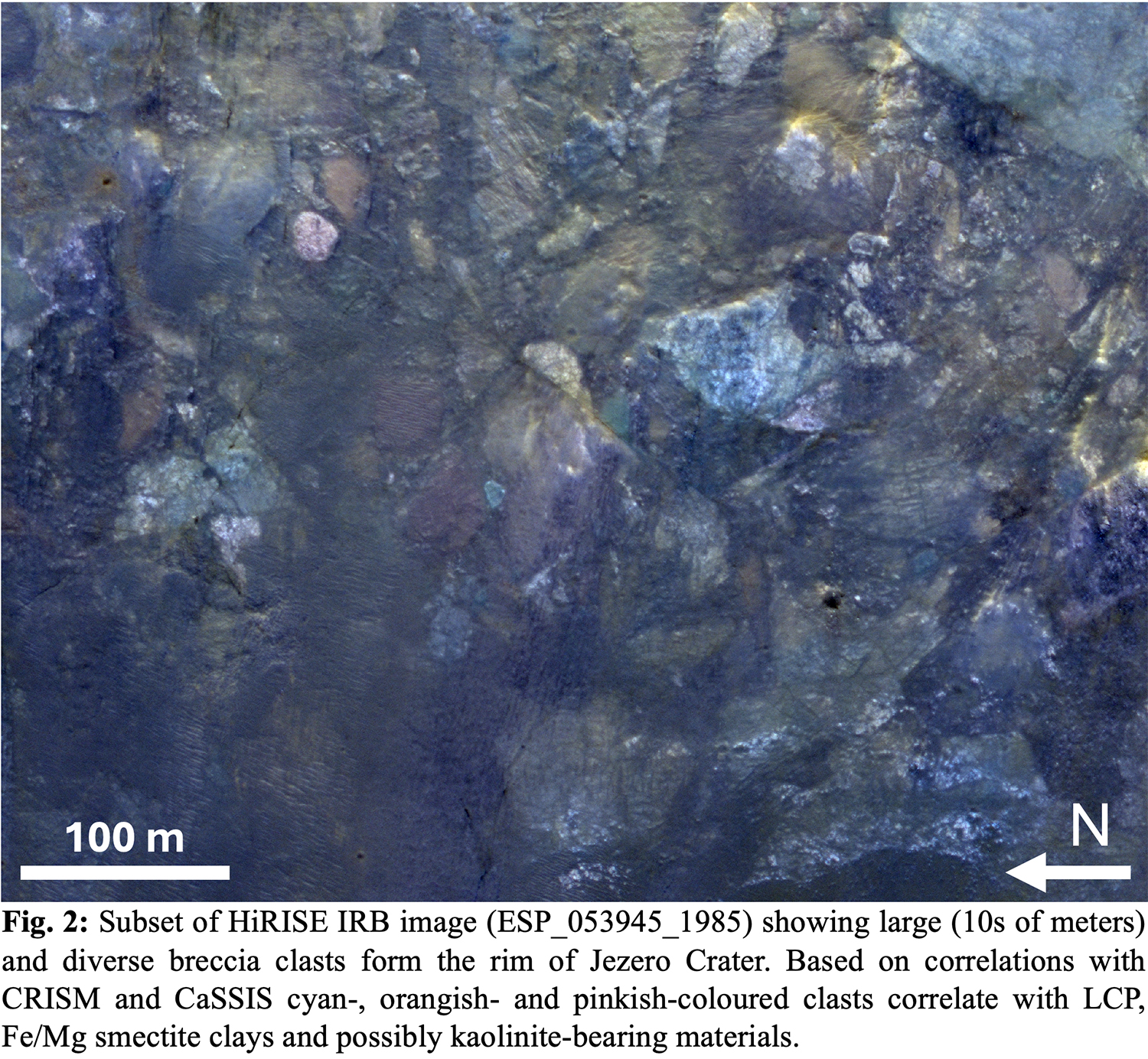
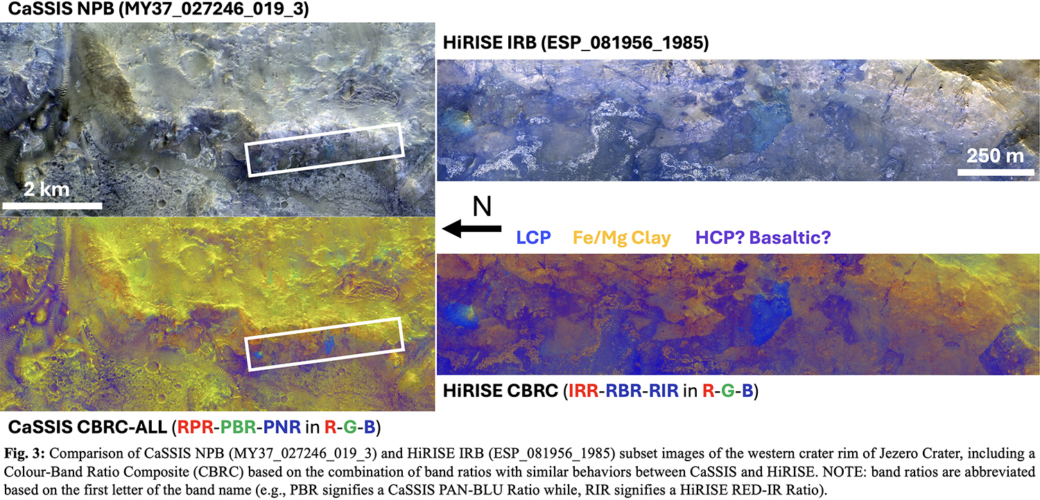
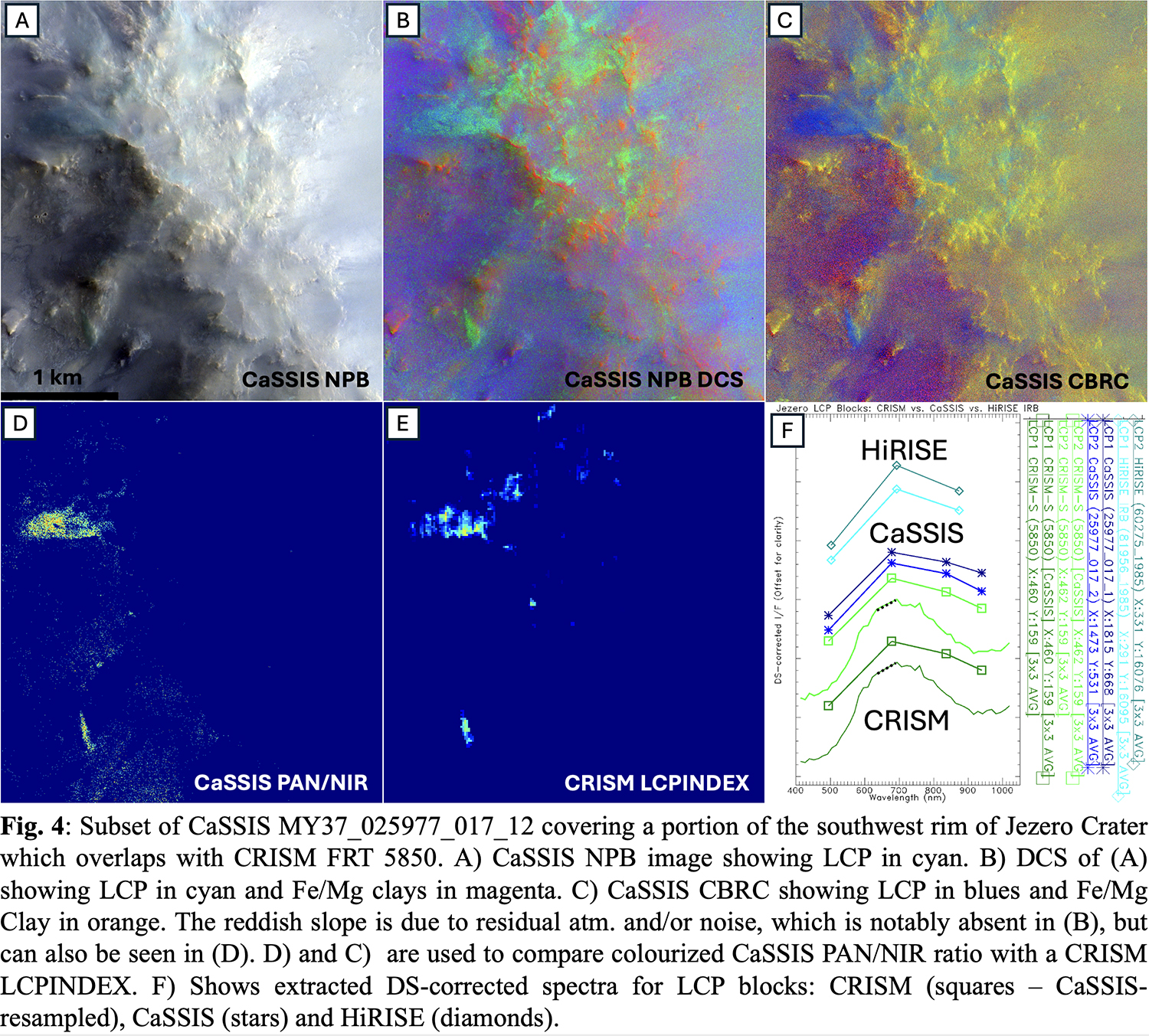
TP15 | ExoMars Rosalind Franklin Mission Special Session

TP15

ExoMars Rosalind Franklin Mission Special Session
Co-organized by MITM
Conveners: Nicole Schmitz, Elliot Sefton-Nash, Jorge Vago, Andrew Coates, Bernard Foing
Orals
| Mon, 09 Sep, 10:30–12:00 (CEST)|Room Jupiter (Hörsaal A)
Posters
| Attendance Mon, 09 Sep, 14:30–16:00 (CEST) | Display Mon, 09 Sep, 08:30–19:00
Orals |
Mon, 10:30
Mon, 14:30
The renewed ExoMars Rosalind Franklin Mission (RFM), a partnership between ESA and NASA, is scheduled for launch in 2028 and will address one of the most important scientific objectives of our time: to search for signs of life on Mars. Oxia Planum remains the selected landing site and the eight scientific instruments aboard the Rosalind Franklin Rover comprise the ‘Pasteur’ Payload. The unique ability to drill to a depth of 2m and extract samples for processing and analysis by three instruments in the rover’s Analytical Laboratory Drawer (ALD), coupled with its mobility, are key enabling capabilities for the search for biosignatures and for investigation of paleo-environments on early Mars.

This session welcomes submissions regarding the mission and its Pasteur Payload instruments, its scientific investigations, and on research activities pertinent to mission science objectives, including but not limited to: study of the Oxia Planum landing site and related locations, terrestrial analogue studies, astrobiological and sample analysis studies, and other relevant research topics. We also invite submissions regarding synergies between the ExoMars Rosalind Franklin Mission and other Mars missions and programmes.

Orals: Mon, 9 Sep | Room Jupiter (Hörsaal A)

10:30–10:40
|
EPSC2024-856
|
On-site presentation
Elliot Sefton-Nash and Jorge L. Vago

Finding signs of life elsewhere is one of the most important scientific objectives of our time.

From the very beginning in 2002, ExoMars was conceived to answer one question:  Was there ever life on Mars?  All project design decisions have focused and continue to centre on the achievement of this single scientific goal.  This is particularly the case for the Rosalind Franklin rover [1]. Putting the science team in the best possible condition to search for physical and chemical biosignatures has led to:

  • the need for a 2-m depth drill;
  • the choice of payload instruments,
  • the landing site requirements that led to selection of the Oxia Planum landing site, and
  • the surface exploration strategy that guides how the rover and instruments are used together to achieve the mission objectives.

The Rosalind Franklin Mission (RFM) is a re-establishment of the ExoMars 2022 mission. In a new partnership with NASA, RFM is on schedule for launch in 2028. The ExoMars Science Working Team (ESWT), ExoMars project and industrial partners continue to be engaged in a programme of refurbishment of the rover and its instruments, and preservation of science team expertise and knowledge. The revised mission timeline provides great opportunity for further preparatory science, including of the Oxia Planum landing site and its analogues, by interpretation of orbital data, lab- and field-work, and numerical simulations.

The ExoMars Rover Science Operations Working Group (RSOWG), chartered in 2019 by the ESWT, is re-established for the 2028 mission and continues working at a sustainable pace to address specific needs serving to advance science readiness. The ‘Micro’ sub-group work on topics regarding the spatial scale of the samples that will be extracted from down to 2m by the rover’s drill, their analogues, and plans for their analyses, including by the three instruments in the rover’s Analytical Laboratory Drawer (ALD): MicrOmega [2], RLS [3] and MOMA [4]. Ongoing work regards a set of ‘Mission Reference Samples’ – a suite of analogue samples most relevant to the landing site and mission objectives, which are under characterization by ground models of these instruments. Members of the ‘Macro’ sub-group continue geological interpretation of the landing site, and recently have published the highest resolution geologic map of Oxia Planum, the culmination of a 4-year team effort [5]. In addition, a dedicated set of co-authors are preparing the Strategic Science Plan (SSP) of the mission, which traces mission science objectives, through to specific questions linked to hypotheses that are testable by the scientific instruments in the ‘Pasteur’ Payload.

A new European Entry Descent and Landing Module (EDLM) that is being developed will deliver Rosalind Franklin to Oxia Planum. Meanwhile, dedicated efforts are underway to maintain, and update as needed, systems at the Rover Operations Control Centre (ROCC - Turin, Italy). A continued plan of testing and simulations is planned in the coming years at ROCC, providing opportunities to exercise Science and Control Team processes. On the flight model of the Rosalind Franklin rover, instrument refurbishment activities are underway and a new infrared spectrometer ‘Enfys’ is in development to replace the analytical capabilities of the now disembarked ISEM instrument.

A special Science Knowledge Management Programme (SKP) has been set up and is now supporting key expertise within the science and instrument teams. SKP ensures that the valuable team knowledge and experience that was built in preparation for the 2022 mission opportunity [6] can be retained and developed.

This presentation will explain how ESA, with NASA partners, has reconfigured the Rosalind Franklin mission for a launch in 2028, present the current the level of advancement of the project, and will highlight the main science objectives and overall strategic plan for the mission.

Figure 1: Artist’s view of Rosalind Franklin approaching hydrothermal mound remains.

References

[1] Vago, J. L. et al. Habitability on Early Mars and the Search for Biosignatures with the ExoMars Rover. Astrobiology 17, 471–510 (2017).

[2] Bibring, J.-P., Hamm, V., Pilorget, C., Vago, J. L. & the MicrOmega Team. The MicrOmega Investigation Onboard ExoMars. Astrobiology 17, 621–626 (2017).

[3] Rull, F. et al. The Raman Laser Spectrometer for the ExoMars Rover Mission to Mars. Astrobiology 17, 627–654 (2017).

[4] Goesmann, F. et al. The Mars Organic Molecule Analyzer (MOMA) Instrument: Characterization of Organic Material in Martian Sediments. Astrobiology 17, 655–685 (2017).

[5] Fawdon, P. et al. ‘The high-resolution map of Oxia Planum, Mars; the landing site of the ExoMars Rosalind Franklin rover mission’, Journal of Maps, 20(1) (2024). doi: 10.1080/17445647.2024.2302361.

[6] Sefton-Nash, E. et al. Science Operations Readiness of the ExoMars 2022 Rover Mission. in Lunar and Planetary Science Conference LPI Contributions 2678. Abs. 2109 (2022).

How to cite: Sefton-Nash, E. and Vago, J. L.: ExoMars/Rosalind Franklin Mission Update, Europlanet Science Congress 2024, Berlin, Germany, 8–13 Sep 2024, EPSC2024-856, https://doi.org/10.5194/epsc2024-856, 2024.

10:40–10:50
|
EPSC2024-1080
|
On-site presentation
Peter Fawdon, Csilla Orgel, Solmaz Adeli, Matt Balme, John Carter, Joel Davis, Elena Favaro, Alessandro Frigeri, Pete Grindrod, Emma Harris, Ernst Hauber, Damien Loizeau, Joe McNeil, Lucia Mandon, Cathy quantin-nataf, Amelie Roberts, Nick Thomas, Elliotte Sefton-Nash, and Jorge Jago

Oxia Planum is the selected landing site for the ExoMars Rosalind Franklin (RF) Mission, launching in 2028. The science objectives of the mission are to search for signs of life and to characterize the geochemical environment in the subsurface as a function of depth. RF will accomplish this with its ‘Pasteur’ suite of scientific instruments, and a drilling and sampling subsystem to retrieve samples for analysis from as deep as 2 m [1].

In preparation for this mission ESA, though the Rover Science Operations Working Group (RSOWG), has conducted a program of high resolution morphostratigraphic mapping and analysis to understand the geological significance of the landing site, to provide context for in-situ sample analysis and to serve as an input into strategic planning for rover operations. This effort: (i) has defined and described the geography of Oxia Planum as a framework for its exploration [2], (ii) has produced a geological map of the landing site [3], and (iii) in our ongoing work, is building a set of geological hypotheses that the RF rover can test during its nominal mission (in 2030-2031).

Figure. 1: The (a) location and (b) context of Oxia Planum, inc. the availability of CaSSIS data which has been critical to developing our regional understanding. (c) The geological map of the Oxia Planum landing site summarizing the major unit groups (see Figure 2).

Oxia Planum (Figure 1) preserves a record of the diverse geological process that formed and modified the landscape of western Arabia Terra throughout Mars’ geological history. Noachian Terrains contain extensive phyllosilicate–bearing materials in an environment of widespread aqueous alteration [4-7]. These deposits were subsequently added to (and modified by) fluvial activity and burial beneath regional layered terrain in the early Hesperian. They experienced further burial and erosion throughout the Amazonian [8-11]. Consequently, exploring the cross–section of strata exposed in Oxia Planum informs us about the paleoenvironmental conditions across a significant part of martian geological history (symbolized in Figure. 2). Furthermore, as Oxia is topographically open to the north, the processes recorded there probably reflect those occurring along the dichotomy boundary across the wider Chryse/Arabia region [4, 11- 15].

We present: (1) The high-resolution geological map of the landing site in Oxia Planum [3] and the data used to create it [2]. (2) An overview of hypotheses relevant to key events in Oxia Planum's geological history. (3) A discussion of how future RF observations will impact these questions and our wider understanding of Mars.

Figure 2: A summary of our current working hypotheses for the history of Oxia Planum visualized as an East to West schematic cross-section through the Oxia Basin. This connects the major geological units (Figure 1) to outstanding questions, the answer to which will tell us more about the overall geological evolution of Mars.

Acknowledgments: We thank the CaSSIS and HiRISE teams for ongoing data collection in support of the RF rover mission. PF thanks UK Space Agency (ST/W002736/1) and the ExoMars Science Knowledge Program (SKP) for funding.

References: [1] Vago et al. (2017) Astrobiology 17 (6–7), 471–510. [2] Fawdon, et al. (2021) J. Maps, 17:2, 621-637. [3] Fawdon et al. (2024) J. Maps 20(1). [4] Carter J. et al. (2015) Icarus 248, 373-382. [5] Quantin et al. (2021) Astrobiology 21:3, 345-366. [6] Mandon et al. (2021) Astrobiology 21:4, 464-480. [7] Brossier et al. (2022) Icarus 386. [8] McNeil et al. (2023) in LPSC 54 Abs.#1252. [9] Fawdon et al. (2022) JGR-Plan. 127, e2021JE007045. [10] Davis et al. (2023) EPSL 601, 117904. [11] Woodley et al. (2023) J. Maps, [12] Frueh et al. (2023) LPSC 54 Abs.#1440. [13] McNeil et al. 2022 JGR-Plan. 127, e2022JE007246. [14] Molina et al. (2017) Icarus 293 27-44. [15] Tornabene et al. (2023) LPSC 54 Abs.#2727

How to cite: Fawdon, P., Orgel, C., Adeli, S., Balme, M., Carter, J., Davis, J., Favaro, E., Frigeri, A., Grindrod, P., Harris, E., Hauber, E., Loizeau, D., McNeil, J., Mandon, L., quantin-nataf, C., Roberts, A., Thomas, N., Sefton-Nash, E., and Jago, J.: Scientific hypotheses for the ExoMars Rosalind franklin rover mission: a geological history of Oxia Planum., Europlanet Science Congress 2024, Berlin, Germany, 8–13 Sep 2024, EPSC2024-1080, https://doi.org/10.5194/epsc2024-1080, 2024.

10:50–11:00
|
EPSC2024-927
|
On-site presentation
Andrew Coates, Nicole Schmitz, Matt Balme, and Matt Gunn and the Rosalind Franklin PanCam team

The scientific objectives of the Rosalind Franklin (ExoMars) 2028 rover are designed to answer several key questions in the search for life on Mars by drilling 2m under the surface. The PanCam instrument, with the other context instruments, will set the geological and morphological context for the mission. Here, we will describe the PanCam scientific objectives in geology, atmospheric science and 3D vision. We also describe the design of PanCam as delivered to the rover. PanCam includes a stereo pair of Wide Angle Cameras (WACs), each of which has an 11-position  filter wheel for geology and atmospheric science, and a High Resolution Camera for close up investigations. The cameras are housed in an optical bench at the top of the rover’s mast, which also includes the electrical interface via the PanCam Interface Unit (PIU). PanCam also includes a calibration target, fiducial markers and a rover inspection mirror. We will describe how PanCam will work with Enfys and other context instruments to help decide where to drill. We also discuss some results from PanCam testing during field trials.


How to cite: Coates, A., Schmitz, N., Balme, M., and Gunn, M. and the Rosalind Franklin PanCam team: PanCam: the ‘science eyes’ of the Rosalind Franklin (ExoMars 2028) rover, Europlanet Science Congress 2024, Berlin, Germany, 8–13 Sep 2024, EPSC2024-927, https://doi.org/10.5194/epsc2024-927, 2024.

11:00–11:10
|
EPSC2024-939
|
On-site presentation
Valerie Ciarletti, Alice Le Gall, Emile Brighi, Nicolas Oudart, Yann Hervé, Dirk Plettemeier, Wolf-Stefan Benedix, Sebastian Hegler, Yun Lu, Charlotte Corbel, and Rafik Hassen-Khodja

Introduction

The ExoMars Rosalind Franklin Rover exobiology mission is now scheduled to launch in 2028 to search for traces of past or present life in the shallow subsurface of Oxia Planum [1],[2]. The Rover is equipped with a drill capable of taking samples up to 2 m deep where organic molecules and possible biosignatures are likely to be preserved. The WISDOM GPR was designed specifically for the mission's objectives [3],[4]: it will provide images of the Martian subsurface down to a few meters which will contribute, together with the other instruments of the payload, to the understanding of the geological context of the landing site. The article focuses on the signal and data processing tools that have been developed, validated on simulated data and eventually implemented in the pipeline that will be used for the interpretation of Martian data. Applications to experimental data collected during field campaigns will be presented.

The WISDOM instrument

Two GPRs (RIMFAX on board the Perseverance rover (NASA) [5] and RoSPR on board the Zhurong rover (CNSA) [6]) operated on Mars, have demonstrated the potential of GPRs to provide, in a non-destructive way, first-hand information about the subsurface, which is essential for a comprehensive understanding of the geological context of the investigated area. WISDOM has been designed to image the Martian subsurface down to at least 2-3 meters with a few-centimeter vertical resolution, which is required to be consistent with the size of the core samples that will be collected by the ExoMars Rosalind Franklin Rover drill. WISDOM is a polarimetric, step-frequency GPR operating in the frequency domain over an ultra wide band from 500 MHz to 3 GHz.

The WISDOM FM has been thoroughly characterized end-to-end [7] in the laboratory and also once accommodated on the Rosalind Franklin rover in order to document the interactions between the rover structure and the radar radiation pattern, and take them into account in order to avoid possible misinterpretations of the future Martian data.

On Mars, while the rover is moving at the surface, WISDOM will perform electromagnetic soundings, typically every 10 cm in order to automatically produce radargrams (i.e. images of the subsurface showing, along the rover track, the amplitude of the radar signals back-scattered by permittivity contrasts in the subsurface as a function of the propagation delay).  Since WISDOM operates in the frequency-domain, an Inverse Fourier Transform (IFT) needs to be applied to the frequency domain data to obtain the response in time-domain, which provides the subsurface images. In order to specify the depth of any structure detected in the Oxia Planum subsurface, the measured propagation delays must be converted to depths, which requires an estimated value of the average subsurface permittivity.

A number of algorithms have been used to develop tools to process the data and produce the data products that will allow to maximize the scientific return of the instrument and of the mission.

Data processing

As previously mentioned, WISDOM operates in the frequency-domain and a number of processing techniques are directly applied on the raw data before IFT: free space removal to suppress parasitic signals (electronic coupling, antenna crosstalk, multiple reflections on the rover body, etc), windowing to reduce sidelobe contribution and whitening for spectrum frequency-dependent compensation [7]. 

Eventually, the Bandwidth Extrapolation (BWE) technique has been implemented to enhance WISDOM radargrams vertical resolution [8] by a factor of up to 3. Recently, we released the first open-source BWE software, as a Python library named « PyBWE » [9].  (see Oudart et al. submitted to MITM13 EPSC 2024)

Clear buried interfaces or resolvable large reflecting structures are easily interpretable features in radargrams. However, radargrams most often show diffuse scattering indicative of the presence of heterogeneities that could be pyroclastic, sedimentary or ejecta deposits. Their typical size as well as their shape provide contraints about the origin and transport of materials and therefore about the chronology of geological events. We have thus developed a method to statistically estimate the typical size of buried scatterers [10]. The method requires data produced by ultra-wideband GPR since it relies on the analysis by narrow frequency  sub-bands. Based on numerical simulation, we demonstrated that the size L of the scatterers can be estimated from the wave length value λ that triggers the maximum of volume scattering (L~λ/5). (see  Brighi et al. submitted to TP2 EPSC 2024). For a permittivity value of 5 in the subsurface, the WISDOM data could thus be used to estimate the dimensions of the heterogeneities in the range of  0.9-4.2 cm.

Since, one of WISDOM's objectives is to detect potential buried rocks that could jeopardize drilling activities, we have developed an automated tool for detecting hyperbolic signatures in radargrams [11]. It allows locating the scatterers and also obtaining an estimate of the soil permittivity value (which must be known to convert the measured arrival times into distances). The tool is based on the Hough transform and takes into account the refraction at the surface and therefore applies to all planetary GPRs, such as WISDOM, whose antennas are located a few decimeters above the surface.

Future work will be dedicated to the more time-consuming algorithms that cannot be run in real time but will enable deeper data interpretation (for example, by comprehensively exploiting WISDOM's polarimetric capability).

[1] Vago et al. (2017), Astrobiology, 17 (6-7).[2] Fawdon et al. (2024), Journal of Maps, 2024, 20 (1)  [3] Ciarletti et al. (2011), Proceedings of the  IEEE, vol. 99, no. 99 . [4] Ciarletti et al. (2017), Astrobiogy 17 (6-7)   [5] Hamran et al. (2022), Mars. Sci. Adv. 8 [6] Zhou et al. (2020),  Physics 4   [7] Hervé et al. (2019), Planetary and Space Science, 189, pp.104939 [8] Oudart et al. (2022) Planetary and Space Science, 224, pp.105606 [9] Oudart et al., 2024 (in review), Journal of Open Source Software [10] Brighi et al. (in review), Planetary and Space Science. [11] Oudart et al. (2021) Planetary & Space Science 197, pp.105173. 

How to cite: Ciarletti, V., Le Gall, A., Brighi, E., Oudart, N., Hervé, Y., Plettemeier, D., Benedix, W.-S., Hegler, S., Lu, Y., Corbel, C., and Hassen-Khodja, R.: The WISDOM GPR on board the ESA’s ExoMars Rosalind Franklin Rover – Focus on tools developed for a quantitative data interpretation, Europlanet Science Congress 2024, Berlin, Germany, 8–13 Sep 2024, EPSC2024-939, https://doi.org/10.5194/epsc2024-939, 2024.

11:10–11:15
11:15–11:25
|
EPSC2024-183
|
On-site presentation
Clara Azémard, Rachel Gonthier, Brieux Bouhier, Fabien Stalport, Kévin Lepot, and Hervé Cottin and the MOMA team

The Mars Organic Molecule Analyzer instrument (MOMA) is part of the ExoMars payload and aims to characterise the organic matter at the surface and subsurface of Mars. MOMA can be used under different configurations in order to achieve the study of the various samples that will be analysed by the rover. Crushed samples can be analysed by LD-MS, Pyr-GC-MS or wet chemistry – GC-MS. In this presentation we will focus on this last option. During the wet chemistry, the crushed samples will be put in an oven containing a derivatisant capsule. The chemical reagent inside the capsule enables a better volatilisation of our target molecules such as amino acids and carboxylic acids. Three different reagents are present in MOMA: DMF-DMA, TMAH and MTBSTFA. We focused most of our work on the later one. MTBSTFA is sealed in metallic capsules that open only at 221°C thanks to a eutectic. This is far from the temperature used in usual laboratories condition hence the need to adjust the time of reaction.

In order to optimise the characterisation of the organic matter with MOMA, each steps of sample preparation inside MOMA ovens must be optimised under the in-situ conditions: extraction and derivatisation. First, the thermal desorption of the organic molecules from analogues must be addressed. The thermal desorption was carried out at 200°C to stay under the eutectic but be high enough to be able to desorb the molecules from the mineral matrix. We need to desorb the molecules bonded to the mineral structure without degrading them. In order to optimise this desorption, Orbagnoux rock was used as analogue and showed good yield between 5 and 7 minutes of heating.

Only then, we focused on the derivatisation reaction. The first step is to make sure that the reagents will still be active after many years waiting for ExoMars flight to Mars. Experiments were carried out on control vials and capsules from 2015 for two derivatisants: DMF-DMA and MTBSTFA. Ancient reagent yields of functionalisation of amino acids were confronted to recent ones, showing comparable results. The effect of metal was effectuated by removing the capsule’s eutectic and draining the solvent with a syringe. The second step is to optimise the derivatisation of our target molecules. Three points were to be tackled: (i) the absence of DMF along with MTBSTFA in the capsule contrary to the common reaction in the laboratories, (ii) the temperature of derivatisation, (iii) the by-products appearing under these conditions. The first point revealed as expected a loss of signal for amino acids yet they can still be detected. The optimisation of the time of derivatisation leads to an optimum at 4 minutes, after that the amino acids tend to degrade due to the heat. Numerous by-products are observed, most of them are just partially derivatised amino acids or due to cyclisation through heating (Figure 1). The database associated to MOMA will be completed with these new compounds. Interestingly, depending on the initial mix we also observe the apparition of a-aminobutyric acid, a non proteinogenic amino acids that is commonly found in space objects such as meteorites. If our wet chemistry can induce the apparition of such compounds the conditions of apparition must be thoroughly understood to avoid misinterpretation of results on Mars. Linear and aromatic carboxylic acids showed good derivatisation under MOMA conditions.

Figure 1. Derivatisation with MTBSTFA of proline at 75°C and 220°C

The optimisation of the sample preparation inside MOMA ovens can be integrated in a lager vision of the process in term of heating time in the oven and therefore energy (Figure 2). It is important to have this general view in the perspective of keeping the maximum of energy to achieve the GC-MS run afterward. Indeed, molecules with higher masses will need a longer time of run so each minute will count.

Figure 2. Temperature profile of the MOMA oven during the different steps of sample preparation and after capsule opening.

How to cite: Azémard, C., Gonthier, R., Bouhier, B., Stalport, F., Lepot, K., and Cottin, H. and the MOMA team: In-situ sample preparation with MOMA instrument, derivatisation with MTBSTFA – ExoMars 2028 mission, Europlanet Science Congress 2024, Berlin, Germany, 8–13 Sep 2024, EPSC2024-183, https://doi.org/10.5194/epsc2024-183, 2024.

11:25–11:35
|
EPSC2024-638
|
ECP
|
On-site presentation
Lorenzo Rossi, Francesca Altieri, Alessandro Frigeri, Simone De Angelis, Maria Cristina De Sanctis, Marco Ferrari, Sergio Fonte, Michelangelo Formisano, Alessandro Pilati, Matteo Paolo Clemente, Lucia Cordeschi, Andrea Merlo, Luc Joudrier, Elliot Sefton-Nash, and Jorge Vago

Rosalind Franklin will be the first Mars rover capable of drilling into the surface of Mars down to a depth of 2 m. Its drill system is designed to collect small core samples at depth and deliver them to the analytical instruments inside the rover body. This capability is instrumental in the search for traces of past life, as chemical biosignatures are better preserved and more likely to be detectable below the surface [1]. It also enables the investigation of the mineralogy and stratigraphy of the shallow subsurface environment of Mars, providing a more complete understanding of the geology of the landing site, Oxia Planum.

During its operation, the drill system records a broad collection of telemetry data, including temperature, force, torque, and speed readings. Once downlinked to ground, telemetry data enables the assessment of the drilling operation progress and system health status. But drill telemetry can also offer valuable information about the mechanical properties of the rocks the drill bores through, thus providing additional clues about the geology of drilling site. When used in synergy with the information provided by the rover’s science instruments, it can improve the overall characterization of the subsurface environment where core samples are collected and inform their analysis [2].

To this end, we are developing data analysis techniques and custom data processing and visualization tools to extract scientifically relevant information from drill telemetry data.
One of the main goals is to extract information about the stratigraphy of the drilling site. Differences in the mechanical properties of stratigraphy layers are linked to variation in the composition and cohesion state. The detection of such variations can provide information to improve the understanding of the geologic history of the site.
An example of some informative parameters that can be derived from drill telemetry data is shown in Figure 1. Here various quantities are shown against depth, thus highlighting the variability of the mechanical behaviour of different stratigraphy layers. The telemetry dataset shown here comes from a Ground Test Model (GTM) drilling test carried out in February 2023. In this case adjacent stratigraphy layers had very different mechanical properties, making the detection of the interfaces between them rather easy. However, some more advanced techniques will be needed to detect subtler differences. Another example of the variation seen in drill telemetry data corresponding to the interface between two different materials is shown in Figure 2. Here we see the drill moving from a loose material to one that is harder to drill. In addition to the decrease of the vertical speed and increase of drill torque, also the power density spectrum of the torque sensor reading varies. This hints to the information content of the time evolution of the telemetry data. Indeed, most of the best-performing analysis methods we tested so far also use some information about the time evolution of the telemetry data, rather than only using values from a single timestep.

Figure 1 - Quantities derived from drill telemetry data from February 2023 GTM drilling tests.


Figure 2 – Variation of the measured drill torque at the interface between two layers with.


To assess the information content of the various drilling parameters, we employed several dimensionality reduction and clustering algorithms. These methods are also useful to provide a preliminary assessment of drill telemetry with some “blind” indications about the presence of layers with different properties, without requiring a-priori information. Figure 3 shows a representation of a telemetry dataset in a 2-dimensional embedding space obtained with the t-SNE (t-distributed stochastic neighbour embedding) algorithm. This representation shows similar data points closer together. Here each point represents a 20 second interval of telemetry data and is coloured as a function of depth. However, depth was not included among the features the embedding was computed from, and the fact that lumps of points result to be close together also in depth gives a first indication of the presence of layers with different properties. Similar conclusions can be drawn from the results of clustering algorithms such as HDBSCAN, shown in Figure 4. These results indicate that substantial information about the properties of the material is indeed contained in drill telemetry data.

Figure 3 - t-SNE visualization of a drill telemetry dataset.
Each point represents a 20-second span of drill telemetry.

Figure 4 - HDBSCAN clustering results.
Each cluster is shown in a different colour.


In addition to the unsupervised learning methods mentioned so far, we also developed some supervised classification models based on 1D convolutional neural networks. After training and hyperparameter tuning, such models achieved a very high accuracy in recognizing different materials, but their general applicability is still limited as they were trained on a limited dataset, with very few reference materials.

We are now working towards generating a larger reference dataset to improve our analysis methods, combining data from both GTM drilling tests and the qualification tests of the drill performed in Mars-like conditions. New GTM drilling tests will be carried out in the future, providing additional data and the opportunity of further enhancements. We are also trying to better define some quantitative metrics to assess and compare the performance of different analysis techniques under different scenarios. In addition, we are working on a more detailed assessment of the information content of drill telemetry data: we aim to investigate the limits of layer interface detection and estimate the accuracy of classification models under more realistic settings. Finally, even more test data will enable the pursuit of a further goal: the development of models that, in addition to a qualitative classification, also provide a direct quantitative estimate of some mechanical properties, such as the uniaxial compressive strength.


References

[1]     Vago J.L. et al, Astrobiology, vol 17, n.6-7 (2017)
[2]     Altieri F. et al., Advances in Space Research (2023)

How to cite: Rossi, L., Altieri, F., Frigeri, A., De Angelis, S., De Sanctis, M. C., Ferrari, M., Fonte, S., Formisano, M., Pilati, A., Clemente, M. P., Cordeschi, L., Merlo, A., Joudrier, L., Sefton-Nash, E., and Vago, J.: Assessing the information content of rover drill telemetry data for the characterization of the shallow subsurface of Mars, Europlanet Science Congress 2024, Berlin, Germany, 8–13 Sep 2024, EPSC2024-638, https://doi.org/10.5194/epsc2024-638, 2024.

11:35–11:45
|
EPSC2024-302
|
On-site presentation
John Robert Brucato, Cristina Garciá Florentino, Ophélie McIntosh, Teresa Fornaro, Andrew Alberini, Sole Biancalani, and Sandra Siljeström

Missions on Mars have already demonstrated its past habitability (Arvidson et al., 2014; Fornaro et al., 2018a; Grotzinger et al., 2014) and the search for biosignatures, such as the identification of organic molecules, has become one of the main goals of exploration programs (Fornaro et al., 2020; Horneck et al., 2016). Specifically, data collected by the SAM instrument showed the presence of thiophenes, aromatics, aliphatic and thiol derivatives in the Murray and Sheepbed mudstones, similar to the analysis of the Tissint Mars meteorite (Eigenbrode et al., 2018). However, organics on the surface of Mars are continuously exposed to harsh environmental conditions. Among them, the UV and ion radiation is known for its critical implications on the organic matter present in the soil.

Thus, an understanding of the environment in which organic matter evolves on the Martian surface is important. Specifically, minerals play a crucial role in the processes experienced by organic molecules on Mars, influencing their chemical evolution. The preservation state of organic molecules is often regulated by their interaction with the mineral phase in which they are embedded. Investigations on the catalytic and protective properties of different Martian minerals under Mars-like conditions have been carried out (Fornaro et al. 2018b), who concluded that in several paleoenvironments on Earth, the long-term preservation of terrestrial biosignatures is attributed to sedimentary materials, in particular phosphates, silica, clays, carbonates and metalliferous materials. However, the simple classification of Martian minerals as catalytic or protective is not possible because the behaviour of minerals under Martian conditions depends on the organic molecules involved and their specific interactions with the mineral surface sites. It is therefore important to study the response of specific molecule-mineral complexes to UV and ion irradiation.

In this work, we investigated the likelihood that amino acids and fatty acids biomarker embedded in minerals would be preserved despite Martian chemical weathering by energetic irradiation, and therefore be observable by analytical techniques on board of Rosalind Franklin rover.

References

  • Arvidson RE, Squyres SW, Bell JF, et al. Ancient Aqueous Environments at Endeavour Crater, Mars. Science 2014;343(6169):1248097; doi: 10.1126/science.1248097.
  • Eigenbrode JL, Summons RE, Steele A, et al. Organic Matter Preserved in 3-Billion-Year-Old Mudstones at Gale Crater, Mars. Science 2018;360(6393):1096–1101; doi: 10.1126/science.aas9185.
  • Fornaro T, Steele A and Brucato JR. Catalytic/Protective Properties of Martian Minerals and Implications for Possible Origin of Life on Mars. Life 2018a; 8(4):56; doi: 10.3390/life8040056.
  • Fornaro T, Boosman A, Brucato JR, et al. UV Irradiation of Biomarkers Adsorbed on Minerals under Martian-like Conditions: Hints for Life Detection on Mars. Icarus 2018b; 313:38–60; doi: 10.1016/j.icarus.2018b.05.001.
  • Fornaro T, Brucato J, Poggiali G, et al. UV Irradiation and Near Infrared Characterization of Laboratory Mars Soil Analog Samples: The Case of Phthalic Acid, Adenosine 5-Monophosphate, L-Glutamic
  • Acid and L-Phenylalanine Adsorbed onto the Clay Mineral Montmorillonite in the Presence of Magnesium Perchlorate. 2020; doi: 10.20944/preprints202003.0172.v1.
  • Grotzinger JP, Sumner DY, Kah LC, et al. A Habitable Fluvio-Lacustrine Environment at Yellowknife Bay,Gale Crater, Mars. Science 2014;343(6169):1242777; doi: 10.1126/science.1242777.
  • Horneck G, Walter N, Westall F, et al. AstRoMap European Astrobiology Roadmap. Astrobiology 2016;16(3):201.


How to cite: Brucato, J. R., Garciá Florentino, C., McIntosh, O., Fornaro, T., Alberini, A., Biancalani, S., and Siljeström, S.: Survivability of Biomolecules Under Energetic Processes for the Identification of Biosignatures on Mars, Europlanet Science Congress 2024, Berlin, Germany, 8–13 Sep 2024, EPSC2024-302, https://doi.org/10.5194/epsc2024-302, 2024.

11:45–11:55
|
EPSC2024-1171
|
ECP
|
On-site presentation
Amelie Roberts, Sanjeev Gupta, Peter Fawdon, Steven Banham, Joel Davis, and Emma Harris

Introduction: The deposits of ancient sediment fans on Mars can provide valuable insights into aqueous history, past climate conditions, and potential habitability. Fans are made of a suite of different sediment transport and depositional regimes including deltas, fluvial fans, alluvial fans, and submarine fans, all of which have been proposed to have been present on ancient Mars [1-3].

Oxia Planum, the landing site for the ESA’s ExoMars Rosalind Franklin rover mission, is hypothesized to have an extensive aqueous history likely recorded in its phyllosilicate-bearing units and complex sediment fan [4, 5]. The fan body originates from Coogoon Vallis in an area named Raetia Palus (Figure 1) [6]. Previous studies have conducted broad-scale investigations of this fan, proposing both fluvial fan and delta depositional models [5, 7-9]. To develop a more robust depositional model for the origin of the sediment fan, we conducted a photogeological investigation of sedimentary strata associated with this fan using orbital images and derived digital terrain models at a 1:1250 digital map scale.

Data: This investigation was undertaken using a newly created High-Resolution Imaging Science Experiment [HiRISE; 10] and HiRISE DTM mosaic with resolutions of 25 cm/pixel and 1 m/pixel, respectively. We also used Colour and Stereo Surface Imaging System [CaSSIS; 12] data products.

The sediment fan and associated units: The sediment fan consists of three key units with different textures and elevations: the ledge-forming unit (LF), overlain by the Medium-light Toned Smooth Unit (MltS), overlain by the Medium-light Toned Rough Unit (MltR) (Figure 2). Unit LF outcrops beneath the sediment fan as a light-toned ledge with curvilinear fractures (Figure 3). Unit MltS sharply overlies Unit LF with a smooth, medium-light toned, cratered surface. This unit exhibits three dark-toned and two lighter-toned layers, and at one location, inclined surfaces that dip to the northwest (Figure 4). A crater is impacted into this unit and filled with light-toned material, which is then unconformably overlain by Unit MltR. Unit MltR has an irregular surface texture characterised by abundant meter-scale blocks or boulders either on top or within the stratigraphy (Figure 4c).

The basement of Raetia Palus consists of four rock units: a raised linear feature-bearing unit (RL) and a light-toned, orthogonally fractured unit (LF), which is overlain by a dark-toned, pitted unit (P) and a sub-polygonally fractured unit (SF) (Figure 2). The sediment fan overlies Unit SF with a distinct bench-shaped contact (Figure 5). Units SF and P have a diffuse boundary, with Unit SF gradually losing fracture definition, gaining light-toned peaks, and pits infilled with dark-toned material that are characteristic of Unit P (Figure 5). Although the contact between Unit P and the sediment fan is often obscured by a mantling unit and was interpreted to onlap onto the sediment fan [5], we interpret that Unit P is a degraded version of Unit SF that may have been shielded from weathering by the overlying sediment fan.

An irregular ridge occurs within Unit MltR (Figure 2) which can be traced into a ridge extending northward for ~14,210 m, a possible reverse thrust fault identified elsewhere in Oxia Planum [11].

Geomorphology of the sediment fan: The sediment fan at Oxia Planum covers a surface area of 40.5 km2 and encompasses seven sedimentary bodies, labelled A through G (Figure 6; elevations -2965 m and -3039 m). Sediment bodies A through F are composed of the MltS unit. Sediment body A outcrops on the western side of the fan extending over the basin with finger-like extensions. Sediment body B partially overlies a crater within sediment-body A. Sediment body C, west of sediment body B, is intersected by wedge-shaped sediment body E containing inclined surfaces. Sediment bodies D and F form isolated, wide ribbon-like protrusions, and their relation to sediment bodies A through E is unknown.

Sediment body G overlies sediment bodies A through F and is composed of the MltR unit. The sediment body extends westward from the channel for ~5 km until terminating over the underlying lobes as an ~5 m thick irregular scarp with linear ridges.

Discussion and conclusions: The seven sediment bodies in Oxia Planum indicate evidence for at least seven different episodes of sediment deposition with two significant hiatuses from the presence of embedded craters between three sediment fan layers. We hypothesise that the sloping depositional surfaces within sediment body E are clinoform candidates which would indicate deposition into a shallow standing body of water. The distinction in shape and morphology of sediment body G, comprising unit MltR, and the hiatus represented by the infilled crater, may indicate a different depositional environment, potentially a fluvial fan or a delta top, overlying pre-existing fan deposits.

Our results also place the sediment fan in a stratigraphic context. We find that the fan post-dates Unit P and Unit SF - components of a dark-toned capping unit previously interpreted as the youngest rock unit in Oxia Planum [5] - but predates extensional faulting [11].

References: [1] Metz et al. (2009). [2] Fawdon et al. (2018). [3] Wilson et al. (2021). [4] Bowen et al. (2021). [5] Quantin-Nataf et al. (2021). [6] Fawdon et al. (2021). [7] Gary-Bicas et al. (2021). [8] Ivanov et al. (2020). [9] Fawdon et al. (2022). [10] McEwen et al. (2007). [11] Woodley et al. (2024). [12] Thomas et al. (2017).

Figures:

Figure 1: (a) CTX mosaic [6] of Oxia Planum (ExoMars 2028 landing ellipses, yellow; mapping extent, white); (b) HiRISE mosaic of Raetia Palus. 

Figure 2: Photogeologic map, cross-section, and correlation of map units of Raetia Palus.

Figure 3: Unit LF: (a) context and a representative outcrop in (b) HiRISE and (c) CaSSIS.

Figure 4: Units MltS and MltR: with (a) context; (b) apparently steeply dipping surfaces of Unit MltS; (c) surficial boulders/blocks of Unit MltR; (d) gently-inclined light-and-dark-toned bands of Unit MltS. 

Figure 5: Units SF and P: (a) context; the diffuse boundary in (b) HiRISE and (c) CaSSIS; (d) contact with Unit RL and the sediment fan in HiRISE.

Figure 6: Fan bodies against the orthorectified HiRISE mosaic with correlation of sediment bodies.

How to cite: Roberts, A., Gupta, S., Fawdon, P., Banham, S., Davis, J., and Harris, E.: Reconstructing Depositional Environments of the Sediment Fan in Oxia Planum, Mars, Europlanet Science Congress 2024, Berlin, Germany, 8–13 Sep 2024, EPSC2024-1171, https://doi.org/10.5194/epsc2024-1171, 2024.

11:55–12:00

Posters: Mon, 9 Sep, 14:30–16:00

Display time: Mon, 9 Sep 08:30–Mon, 9 Sep 19:00
EPSC2024-850
|
On-site presentation
Peter Fawdon, Csilla Orgel, Solmaz Adeli, Matt Balme, Fred Calef, Joel Davis, Alessandro Frigeri, Peter Grindrod, Ernst Hauber, Laetitia Le Deit, Damien Loizeau, Andrea Nass, Cathy Quantin-Nataf, Elliot Sefton-Nash, Nick Thomas, Ines Torres, Jorge Vago, Matthieu Volat, and Sander De Witte and the ExoMars RSOWG 'macro' Mapping team

Introduction: Oxia Planum (OP) [1] is the selected landing site for the ExoMars Rosalind Franklin (RF) Rover. The goal of the reformulated ExoMars Rosalind Franklin mission, now in planning for launch in 2028, is to search for signs of past and present life and to characterize the water and geochemical environment in the subsurface as a function of depth. RF will accomplish this with its ‘Pasteur’ suite of scientific instruments, and a drilling and sampling subsystem to retrieve samples for analysis from up to 2 m depth [2].

In preparation for the 2022 mission, The ExoMars science team undertook a geological mapping exercise of the landing site [3] prioritizing the 1-sigma area of the 2022 landing ellipses (Fig 1). The goal of this map is to develop a thorough understanding prior to rover operations of the OP landing site’s geography, stratigraphy, and geological history, and to provide testable hypotheses to facilitate interpretation of results and address the mission’s science objectives.

Here we present the completed map of Oxia Planum, our interpretations of the major geological units, the leading hypotheses for some major units and implications for astrobiology goals of the mission. 

Figure 1: The compleated map sheet of the 1:25,000 scale landing site map (https://www.tandfonline.com/doi/full/10.1080/17445647.2024.2302361 )


Progress: The compleat map (Figuer 1) is presented at a scale of 1:30,000 and includes 14 bedrock geological units in 6 groups, 6 overlay units and geomorphic linework.

Interpretations and Hypotheses: This map is a detailed investigation into geological units of the proposed landing site; however these units are also representative of the wider Oxia Planum region. To formulate interpretation and hypothesis we incorporate these additional contextual observations and consider a range of possible interpretations and associated confidences presented in [4].

Lower bedrock group (lBg; lBg1, lBg 2, lBg3) –materials with orange tone CaSSIS Near IR Panchromatic Blue channel images strongly associated with phyllosilicate spectral signatures. Also includes brighter ‘knobby’ materials, whether these are stratigraphically distinct layers or lateral variation is unclear. Contextual observation suggests the origin of these units may be the upper part of a lacustrine to alluvial succession [5] but it is also likely that the alteration predominantly occurred in situ [6, 7].

Upper Bedrock group (uBg; uBg1, uBg2, uBg3) – uBg1 forms a thin resistant layer directly underlying Mm and oDm units. uBg2 and uBg3 host a boxwork of upstanding ridges associated with high relief areas such as scarps and large ridges. Regionally extensive, this unit crops out as a mantling layer, and contains exhumed fluvial channel bodies, so an origin related to fluvial and groundwater processes is possible, but this may be reworking of widespread volcanoclastic material.

Mound material (Mm; hMm, rMm) – This unit group constitutes isolated hills (hMm) and ridges (rMm), which are part of a regional population. Mm predates the dark group and appears to be remnants of a ~100 m thick layer [8]. However, deposition and erosion mechanics for the unit are unresolved.

Dark material (Dm; oDm iDm) – Thin (~1 m), rough units with lots of trapped regolith, are found at the top of the stratigraphy (oDm) on local topographic highs in regional topographic lows, or interbedded with the lBg

Bright patches (Bp; cfBp, cBp) – Light toned patches with concentric layers occur in (<100m) relic impact structures or larger (>250m), but not infilled, craters.

Crater materials (Cm; nCM, rCm, dCm) – Material relating to impact craters show degradation states varying from fresh dark ejecta (nCm) to degraded and overlain rims (dCm).

Conclusions: The mapping effort is now completed. Since the resumption of the ExoMars mission we are working towards publication of the map, data and accompanying report to support science activities in preparation for the planned 2028 launch. 

Acknowledgments: We thank the CaSSIS and HiRISE teams for ongoing data collection. PF thanks UK Space Agency for funding (ST/W002736/1)

References: [1] Fawdon, et al (2021) Journal of Maps, 17:2, 621-637, [2] Vago, J. et al., (2017) Astrobiology 17 (6–7), 471–510. [3] Sefton-Nash, E. et al., (2021) in LPSC 51, Abs.# 1947. [4] Fawdon P. in LPSC54 abs#2061 [5] Fawdon et al., 2022 JGRp 127, e2021JE007045 [6] Mandon et al, 2022 Astrobiology 2021 21:4, 464-480 [7] McNeil et al, LPSC54 abs#1252 [8] McNeil et al 2022 JGRp 127, e2022JE007246


How to cite: Fawdon, P., Orgel, C., Adeli, S., Balme, M., Calef, F., Davis, J., Frigeri, A., Grindrod, P., Hauber, E., Le Deit, L., Loizeau, D., Nass, A., Quantin-Nataf, C., Sefton-Nash, E., Thomas, N., Torres, I., Vago, J., Volat, M., and De Witte, S. and the ExoMars RSOWG 'macro' Mapping team: The high-resolution map of Oxia Planum, Mars; the landing site of the ExoMars Rosalind Franklin rover mission, Europlanet Science Congress 2024, Berlin, Germany, 8–13 Sep 2024, EPSC2024-850, https://doi.org/10.5194/epsc2024-850, 2024.

EPSC2024-273
|
On-site presentation
William Brinckerhoff, Fred Goesmann, Fabien Stalport, and Cyril Szopa

Introduction:  The Mars Organic Molecule Analyzer (MOMA) investigation is part of the scientific payload of the European Space Agency (ESA) Rosalind Franklin rover mission (RFM, a.k.a. ExoMars) that has been replanned for launch in late 2028, following its earlier suspension. RFM now features a partnership with NASA which provides a launch vehicle, descent engine systems, and radioisotope power supplies in addition to major elements of MOMA. The rover will arrive at Oxia Planum on Mars in 2030 carried by a new ESA-led entry, descent, and landing module (EDLM).

MOMA (Fig. 1) is a dual-source (laser desorption, LD, and gas chromatography, GC) mass spectrometer (MS) that will analyze the organic chemical composition of collected samples in support of the ExoMars/RFM objective to seek the signs of life in the near subsurface (up to two meters depth) of Mars [1]. The dual-source design allows MOMA to provide broadly sensitive detection of organics over a range of molecular weights and volatilities, as well as probe structural patterns of molecules such as enantiomeric ratios or chain length biases in aliphatic species [2].

The deeper drill samples will enable MOMA to examine the organic composition of materials that may have been well protected from degradation by cosmic radiation over geologic timescales.

Flight Hardware Status and Plans: The MOMA flight instrument was delivered to rover assembly, integration, and test (AIT) at Thales Alenia Space – Italy (TAS-I) in 2018. All MOMA functional checkouts since that time have completed nominally and are planned to continue regularly until launch. Items not originally qualified for the much extended “shelf life” or the longer cruise phase have been reviewed and determined to be stable. The team has decided to replace two MOMA elements that since delivery have been found to present risks to achieving the required operational life of at least 218 sols on the martian surface. These are the Power High Voltage module in the MS electronics (produced in the U.S.) and the Gas Chromatograph (produced in France). Refurbished and new elements will be integrated to complete the flight model in 2025. MOMA along with its neighboring instruments in the rover’s Analytical Laboratory Drawer (ALD) – namely the MicrOmega [3] and Raman Laser Spectrometer (RLS) [4] instruments, will subsequently undergo final integrated tests under Mars temperature and pressure conditions to “re-qualify” the ALD payload for flight.

A novel and powerful aspect of the RFM science operation is the co-registration of the overlapping analysis fields-of-view of all three ALD instruments on the delivered sample in the rover’s Refillable Container sample tray (Fig. 2). This collaborative science mode will enable correlation of composition determined by the three techniques (IR reflectance spectroscopy, Raman spectroscopy, and laser desorption mass spectrometry) on the crushed sample. The co-registration will be re-verified in these tests.

Testbed Model: The MOMA Testbed (TB) combines the highest fidelity copy of the flight model, comprising flight spare subsystems, with supporting apparatus to enable operations precisely simulating the RFM environmental and rover conditions in a laboratory Mars thermal vacuum chamber (Fig. 3). The TB is a dual-role facility serving both as an engineering reference for verification and validation of flight procedures and for diagnosing flight performance (including any anomalies or off-nominal situations), and as a science reference with direct traceability to the sensitivity, background, and other characteristics of the FM, with the potential to carry out selected sample studies for scientific interpretation of MOMA data. However, to maintain flight equivalence (including minimal contamination) through the nominal surface mission, such studies using complex analogs on the TB are expected to be rare; rather these will be carried out elsewhere using MOMA lab bench instrumentation.

Engineering Test Unit: A variety of sample studies are conducted in team laboratories, including use of an Engineering Test Unit (ETU) that serves as a “user-friendly” high-fidelity MOMA performance reference (lacking the stringent access restrictions of the TB). The ETU, along with analog instrumentation across the team, permits analyses of analog samples with flight-like protocols, such as:

  • Derivatization GCMS to characterize instrument, sample matrix, and environmental factors in organic detection and amino acid chiral separation;
  • LDMS and LDMS/MS to refine protocols [5] to maximize both sensitivity to heterogeneous, possibly surficial, organics and identify chemical structures;
  • Participation in ExoMars collaborative analysis campaigns, such as with mission analog samples reflecting aspects of possible compositions at Oxia Planum, including phyllosilicate, Fe-oxide, and sulfate mineralogies [6,7], alongside other investigations such as MicrOmega and RLS.

The ETU will additionally serve as a testing, triage, and optimization bench for modified or new protocols and software scripts, prior to their certification on the TB for use on the flight instrument. As such the ETU, in addition to the TB, is expected to perform an operational role within the distributed MOMA team supporting tactical and strategic surface mission activities from remote locations in continual collaboration with the RFM Rover Operations Control Center (ROCC) at the Aerospace Logistics Technology Engineering Center (ALTEC) in Turin, Italy.

Science Operations Preparation: The MOMA team continues to prepare for RFM operations across the spectrum of planning and training for telemetry management, science analysis, and decision-making processes (e.g., flow chart development, science scenario simulation) and role definition. It is considered of prime importance for optimal rover science activities and data analysis to reflect the latest knowledge and hypotheses under development in the Mars science community. Communication and collaboration with diverse groups and ongoing missions is thus envisioned to play an increasingly important role in MOMA science preparations through this decade.

[1] Vago J., Westall F. et al. (2017) Astrobiology, 17, 471-510. [2] Goesmann F. et al. (2017) Astrobiology, 17, 655-685. [3] Bibring J.-P. et al. (2017) The MicrOmega Investigation Onboard ExoMars. Astrobiology, 17, 621-626. [4] Rull F. et al. (2017) Astrobiology, 17,627-654. [5] Siljeström S. et al. (2021) Astrobiology, 21, 1515-1525. [6] Quantin-Nataf C. et al. (2021) Astrobiology, 21, 345-366. [7] Fawdon P., Orgel C. et al. (2024) J. Maps, 20(1), doi: 10.1080/17445647.2024.2302361.

How to cite: Brinckerhoff, W., Goesmann, F., Stalport, F., and Szopa, C.: Mars Organic Molecule Analyzer (MOMA) on the 2028 Rosalind Franklin Rover Mission: Status and Plans, Europlanet Science Congress 2024, Berlin, Germany, 8–13 Sep 2024, EPSC2024-273, https://doi.org/10.5194/epsc2024-273, 2024.

EPSC2024-861
|
On-site presentation
Wolf-Stefan Benedix, Yun Lu, Dirk Plettemeier, and Valérie Ciarletti

Abstract

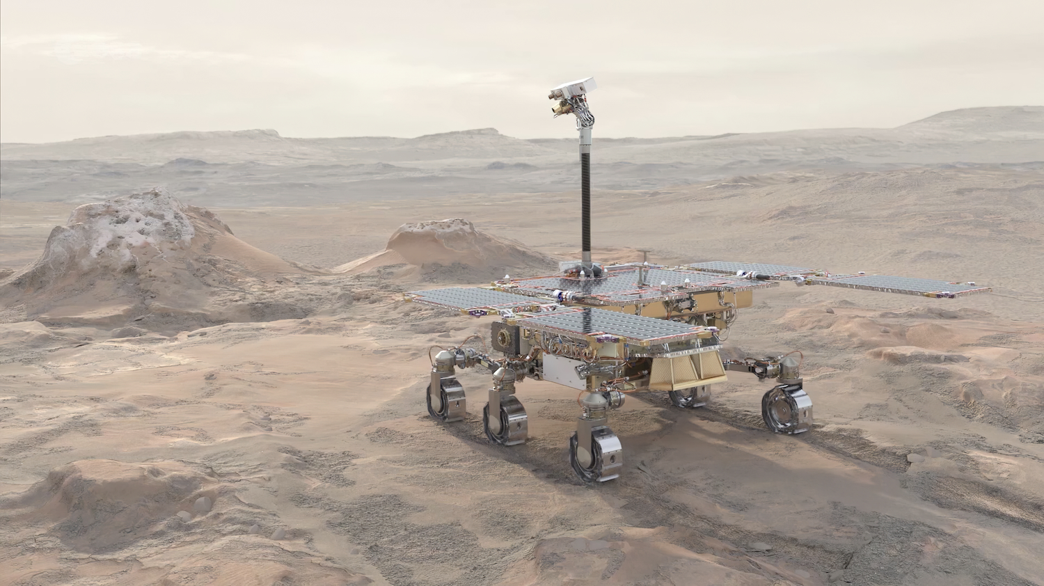
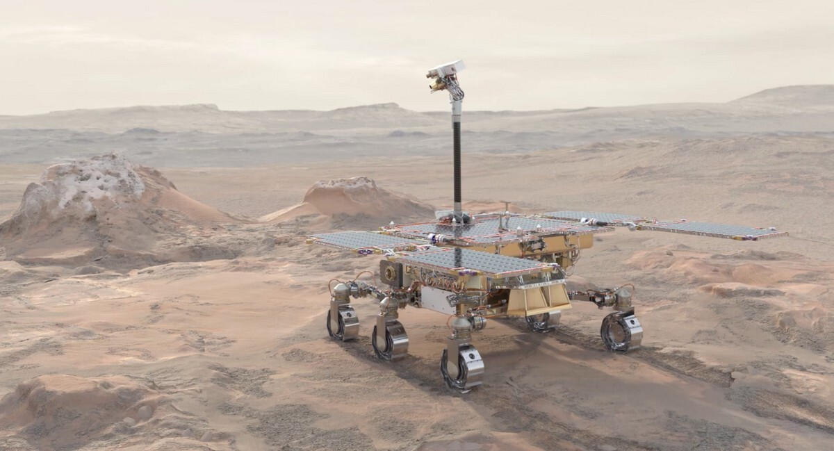
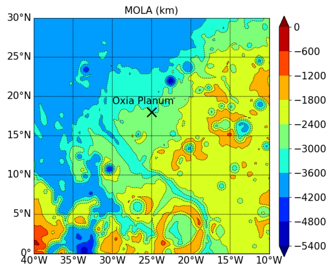
The WISDOM ground penetrating radar aboard the Rosalind Franklin rover is waiting for its intended launch in 2028 within the ExoMars mission. It will search for Water, Ice, and Subsurface Deposit On Mars (WISDOM) to enhance the knowledge of Oxia Planum on Mars. Meanwhile, the WISDOM team is improving the signal processing, since in general the microwave scattering in the sensing channel is a very complex phenomenon [1]. It is mainly determined by the property of transceiver system (radar), of the wireless channel in the random media and the property of the targets to explore. Regarding the target property, it can be divided into two main factors, namely the geometry/shape and the material properties (frequency-dependent relative permittivity). In practice however, due to the high complexity and sensibility of the random scattering signal tracking and separating of these responses is a challenging task by pre-calibration such that it can deteriorate e.g. the subspace image analysis. With radar systems such as WISDOM, which have a distance of up to several wavelengths between the antenna and the ground, there is furthermore an influence from the environment on the radar coupling, which results in an unknown signal. A reasonable tracking/estimation, especially on-site calibration, of these random signal plays then a major role for the radar technologies in practice and will be outlined in this paper.

1 Introduction

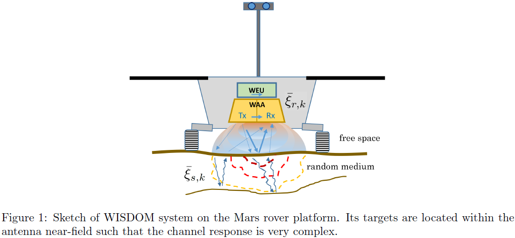
In this paper, we will mainly focus on the random scattering signal analysis for WISDOM and similar GPR-like sensing systems, where the distance between radar system and targets could be very short (close to the antenna near-field). Such that there can be severe signal inter-action between radar and targets.
As a result, both the calibrated radar response and the characteristic response of the target will be distorted and result in unknown signal. In other words, a pre-calibration for radar system and targets in this case will fail. For that, we suggest an on-site coordinate system for those applications.

Regarding concrete applications, it can be summarized (but not limited) as follows:

  •  on-site calibration
  • higher resolution imaging
  • geological feature analysis.

For the purpose above, we introduce the kernel function ξ, which describes each independent channel spectral response, for signal modelling.
The whole received signal then consists of a sum of all convolutions between different kernel functions and their channel impulse responses h. Regarding j-th measured data, that is

However, both kernel functions and their channel impulse responses are unknown in general, due to the quasi near-field effect.

2 On-Site Calibration

The on-site calibration for WISDOM is mainly focusing on the free-space response tracking. This free-space is basically the radar initial working circumstance which is influenced by e.g. the rover platform and Mars ground. This means, every new measured data have always its own coordinate system.
The on-site coordinate system will be extracted by the kernel decomposition, particularly of the strong reflected signal, which are usually dominated by the surface reflected signal. The corresponding coordinate system is equivalent as an on-site calibration in terms of free-space circumstance.

Given multiple measurements, by exploring the coherent property among different data, the calibrated kernels and their channel impulse responses can be summarized as

where Δ is the tracking algorithm. This autonomous calibration is important especially for subsurface signal analysis in terms of e.g. subspace imaging and subsurface scattering dictionary construction. Since all subsurface signal can be considered as some kinds of deviation of the surface signal.

3 Higher Resolution Imaging

High spatial resolution for radar imaging is always an important issue which have been discussed and there are different ways for handling this problem. Generally, the radar image resolution (matched filter based) is limited by the system effective signal bandwidth, which is however finite in practice. An approach to extend the bandwidth by extrapolation for improving range resolution is given in [2].

By considering our model in Eq. 1, the mentioned limited spatial resolution is due to the bandwidth-dependent pulse width of kernel function ξi, while its channel impulse response hi is a sequence of Dirac pulses and exhibits unlimited spatial resolution. Therefore, instead of achieving larger bandwidth, we are trying to extract the channel impulse response alternatively. For pursuing hi, a deconvolution of the kernel function ξi is required, which in turn still depends on the on-site response ξi tracking. In other words, kernel tracking (KT) is a dual problem for higher resolution imaging. In practice, both BWE and KT are proposed for cross-validation.

An extended perspective for higher resolution imaging is a higher precise estimation of kernel function  ξi, which plays a major role for the geological feature's analysis. Basically, the tracking algorithm in Eq. (2) is an iterative process where  ξi and hiare alternatively estimated and tracked. A better estimation of one parameter can improve another parameter estimation. Thus, channel impulse response hi tracking is also a dual problem for kernel function estimation. Finally, higher resolution imaging can be considered as a joint estimation of  ξi and hi.

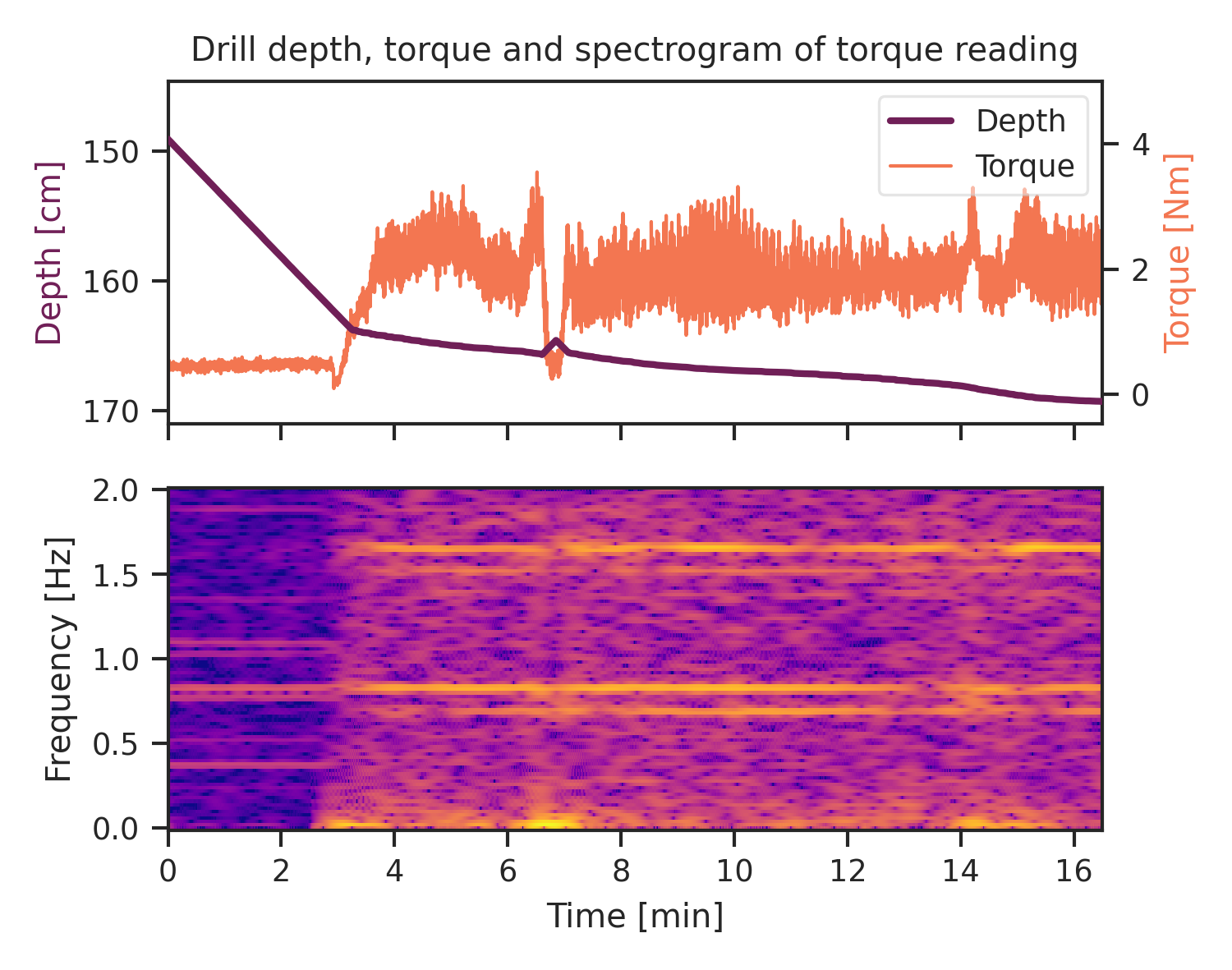
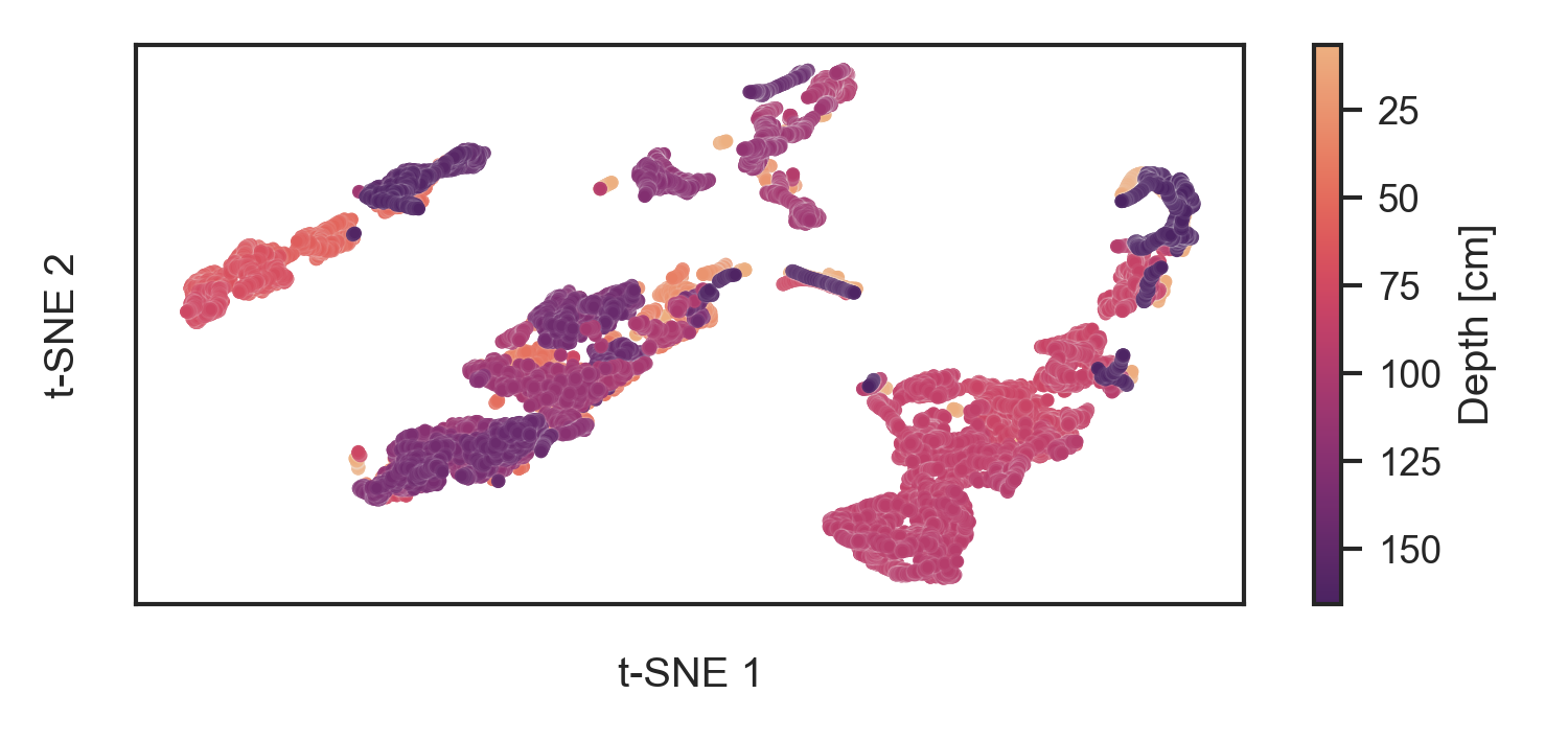
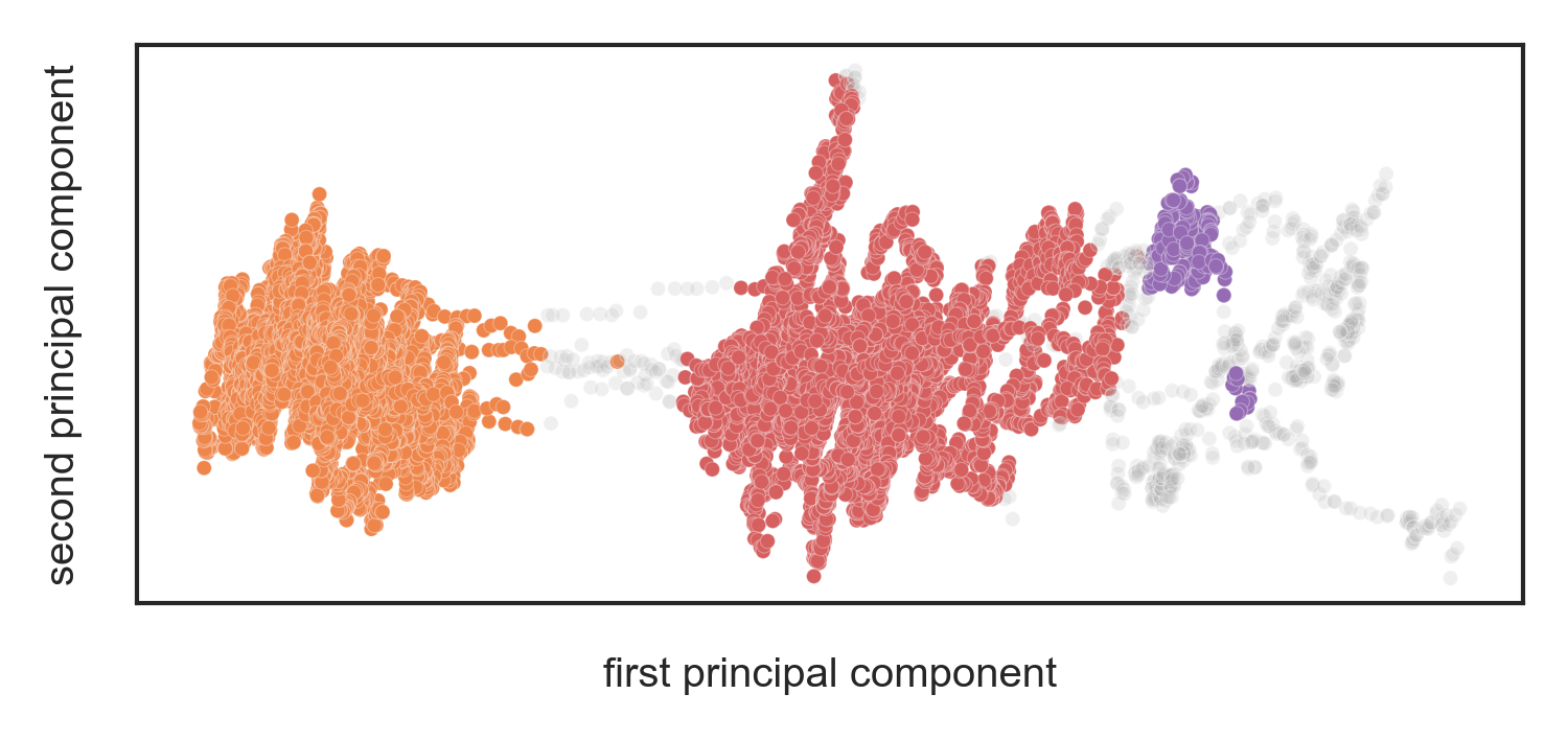
4 Geological Features Analysis

Geological features analysis is basically the core of the WISDOM instrument, where the Mars surface and shallow subsurface properties will be explored. By the WISDOM radar system, these geological features are imprinted mainly over kernel functions ξi, such that kernel function tracking is geological features tracking as well. Certainly, so far we have just indicated this relationship between kernel function and geological properties and therefore cannot describe this relationship explicitly. Besides, this relationship can be distorted easily by all kinds of interference. Nevertheless, one can still present the geological features but in the relative manner, e.g. by unsupervised learning.

References

[1] A. Ishimaru "Wave Propagation and Scattering in Random Media", IEEE Press and Oxford University Press. ISBN 0-7803-3409-4, 1997.

[2] N. Oudart, V. Ciarletti, A. Le Gall, M. Mastrogiuseppe, Y. Hervé, W.-S. Benedix, D. Plettemeier, et al. “Range Resolution Enhancement of WISDOM/ExoMars Radar Soundings by the Bandwidth Extrapolation Technique: Validation and Application to Field Campaign Measurements.” Planetary and Space Science 197 (March 1, 2021): 105173. https://doi.org/10/ght9hk.

How to cite: Benedix, W.-S., Lu, Y., Plettemeier, D., and Ciarletti, V.: On-Site Response Tracking for WISDOM System, Europlanet Science Congress 2024, Berlin, Germany, 8–13 Sep 2024, EPSC2024-861, https://doi.org/10.5194/epsc2024-861, 2024.

EPSC2024-759
|
On-site presentation
Charlotte Segonne, Ehouarn Millour, Luca Montabone, François Forget, and Aymeric Spiga

Introduction: The Rosalind Franklin Rover of the European Space Agency (ESA) will be launched in 2028, as the second part of the ExoMars program. The Rosalind Franklin Rover (RFR) (Fig. 1) will explore the surface and subsurface of Mars in Oxia Planum (18.20°N ; 335.45°E). The aim will be to collect samples of well-preserved organic material down to a depth of 2 m. The Entry-Descent-Landing (EDL) phase of RFR is critical and decisive and requires meeting the engineering threshold constraint for parachute deployment and rover deceleration. Thales Alesia Space Italia is in charge of preparing RFR's EDL. Our contribution to this task is to provide some characterization and forecast of the weather conditions and turbulence in Mars’ atmosphere, for the chosen landing period and area. This is a presentation of the methodology, models and observations/data we will be using.

Figure 1: Representation of Rosalind Franklin Rover on Mars’ surface. (Credits: ESA/Mlabspace)

Methodology: Mars' atmosphere is complex in terms of structure and dynamics. It can be affected by strong winds, presence of water ice clouds and high density of dust particles. The thermal structure of Mars’ atmosphere and its atmospheric circulation are controlled by the amount and transport of airborne dust [1].

Our objective is to represent and characterize Mars’ atmosphere with realistic conditions, while taking into account conditions that can be extreme, to encompass all possible wind and dust density scenarios at the time and in the area of the EDL. To be able to do this fully, models spanning different resolved scales will be used: a General Circulation Model (GCM) that is the Mars PCM (Planetary Climate Model) [2] and the Mars Climate Database (MCD) [2, 3] for global scale, the Mars Mesoscale Model (MMM) [4] for regional scale and microscale model, Large Eddy Simulation (LES) [5], for local turbulence.

Figure 2: Mesoscale domain topography centered on the landing site of Oxia Planum marked by cross.

Numerical Simulations: The landing of RFR is scheduled in 2030, prior to the Martian dusty season (Ls > 180°), after a two-year transfer to Mars. However, although unlikely, the occurrence of local or regional dust storms is plausible and must be taken into account in the simulations. Hence four dust scenarios will be used: climatology, cold (clear atmosphere), warm (dusty atmosphere) and a dedicated scenario (local dust storm). The dedicated scenario will be based on an extrapolation of dust column maps of Mars’ multi-annual climatology of dust distribution (from Mars year 24 to 37) [6, 7] to create a realistic extreme scenario.

Using those dust scenarios, Mars’ atmosphere will be simulated with the Mars PCM and MMM to make regional characterization of the extreme horizontal and vertical winds in Oxia Planum. The mesoscale domain is set to an area ranging from −40° E to −10° E in longitude, and from 0° to 30° N in latitude, covered by 180x180 grid points (Fig. 2) with a horizontal resolution of around 10km. Then, to take into account the convection activity induced by solar surface heating, a local characterization of convective updrafts, downdrafts and shears will be made using LES with an even finer resolution of less than 50m.

Observations and data: The Mars Dust Activity Database (MDAD) [8] and data from instruments such as the spectrometer TES, EMIRS, THEMIS, the radiometer MCS can provide observations of Mars’ atmosphere in Oxia Planum from which water ice cloud horizontal distribution, atmospheric density or temperature profiles can be retrieved.

These observations will serve as a reference to evaluate the outputs of simulations at different scales. And thus makes it possible to assess the possible biases in the simulations that should be taken into account.

References: [1] The Atmosphere and Climate of Mars (2017) ISBN-13: 9781107016187. [2Forget, F. et al. (1999), J. Geophys. Res., 104, E10, 24155-24176. [3] Millour, E. et al. (2024), 10th Mars Conference. [4] Spiga, A., and F. Forget (2009), J. Geophys. Res., 114, E02009. [5] Spiga, A., et al. (2010) Quarterly Journal of the Royal Meteorological Society, 136:414–428. [6] Montabone, L. et al. (2015) Icarus, 251, pp. 65-95. [7] Montabone, L. et al. (2020) J. Geophys. Res. - Planets. [8] Battalio, M. and Wang, H. (2021), Icarus, 354, 114059.

How to cite: Segonne, C., Millour, E., Montabone, L., Forget, F., and Spiga, A.: Characterization of the Martian atmosphere for ExoMars - Rosalind Franklin Rover Entry-Descent-Landing, Europlanet Science Congress 2024, Berlin, Germany, 8–13 Sep 2024, EPSC2024-759, https://doi.org/10.5194/epsc2024-759, 2024.

EPSC2024-312
|
ECP
|
On-site presentation
Luca Maggioni, Matteo Teodori, Gianfranco Magni, Michelangelo Formisano, Maria Cristina De Sanctis, and Francesca Altieri

Introduction

The ESA ExoMars Rover mission will have the task of investigating the Martian soil down to 2 meters providing a physical and chemical characterization of the shallow subsurface by means of an extensible drill [1,2]. For understanding how the drilling activities can affect the already tricky interplay between hydrodynamical and thermal processes that govern the distribution of hypothetical volatile material in the subsurface, numerical models are required. We present preliminary results concerning the evolution of a mixture of ice and water vapour located at a variable depth in the Mars' subsurface through a Smoothed Particle Hydrodynamics (SPH) approach [3]. In addition to show the importance of modelling various physical phenomena like phase transitions and dynamical interactions, we propose a novel approach which consists in coupling the SPH code with Eulerian codes to account for the influence of the drilling activity on the thermal state of the borehole walls.

Methods

Simulations are performed with the help of PySPH [4], an open-source and Python-based framework for SPH. Using a number of pseudo-particles between 20000-30000, we generate a cylindrical fracture with a diameter of about 14 mm and a depth of 12 cm, in which we typically set a layer of ice and water vapour of about 6 cm as shown in Fig.1. The real depth of the hole is computationally unsustainable in the development phase, since it would require a huge number of particles (about 500000) and, consequently, very long simulations. At this point, besides to numerically integrate the hydrodynamics equations that govern the time evolution of the velocity, density, and thermokinetic energy of our multi-component fluid, we need to implement reasonable physical approximations to treat all the other phenomena. Ice-vapour phase transitions are taken into account via a statistical approach by considering the possible sublimation and deposition both for particles in flight and those interacting with Mars' surface. Moreover, dynamical interactions with the internal and external solid boundaries are implemented through a proper mirroring scheme.
In the next steps, we will incorporate into the framework the effects due to the Solar radiation, the viscous drag between solid and gaseous particles, and the heat released on the borehole walls during the drilling operations. For this aim, we assign a temperature gradient to the solid particles of the fracture exploiting the output of an Eulerian code [5].

                                                                            Figure 1: Typical initial conditions.

Preliminary results

In order to test our code, we applied it to two basics problems: a gas sphere expanding adiabatically in space and a classical three-dimensional shock wave expansion. In the first case our results reproduced satisfactorily the analytical profile of a homologous expansion, while in the second case we found a good agreement both with the analytical solution proposed by Sedov [6] and other Lagrangian codes [7,8]. In Fig.2, the comparison is illustrated between the density profile obtained within our simulation using 100000 pseudo-particles and the analytical counterpart.
Currently, the multi-component fluid is influenced solely by dynamical and thermal interactions with the boundary, as well as by phase transitions, in which we included also the contribution due to the latent heat. In particular, after the inclusion of each effect, we ensured that fundamental conservation laws, such as energy conservation, were fulfilled. 

                                                Figure 2: Density profile as a function of the radial distance at a time t = 0.2 s.

Acknowledgments

This work is supported by INAF-IAPS within the project "ExoMars".

Bibliography

[1] A. Coradini et al. “MA_MISS: Mars multispectral imager for subsurface studies”. In: Advances in Space Research 28 (2001), pp. 1203–1208. DOI: 10.
      1016/S0273-1177(01)00283-6.

[2] J. Vago et al. “Habitability on Early Mars and the Search for Biosignatures with the ExoMars Rover”. In: Astrobiology 17 (2017), pp. 471–510.
      DOI: 10.1089/ast.2016.1533.

[3] J. J. Monaghan. “Smoothed particle hydrodynamics”. In: Reports on Progress in Physics 68.8 (2005), pp. 1703–1759.
      DOI: 10.1088/0034-4885/68/8/R01.

[4]  P. Ramachandran et al. “PySPH: A Python-based Framework for Smoothed Particle Hydrodynamics”. In: ACM Transactions on Mathematical Soft-
      ware 47.4 (2021), pp. 1–38. issn: 1557-7295. DOI:10.1145/3460773.

[5] M. Formisano et al. “Subsurface Thermal Modeling of Oxia Planum, Landing Site of ExoMars 2022”. In: Advances in Astronomy 2021 (2021). DOI: 10.
       1155/2021/9924571.

[6] L.I. SEDOV. “CHAPTER IV - One-Dimensional Unsteady Motion of a Gas”. In: Similarity and Dimensional Methods in Mechanics. Ed. by L.I.
      SEDOV. Academic Press, 1959, pp. 146–304. isbn: 978-1-4832-0088-0. DOI: https : / / doi . org / 10 .1016/B978-1-4832-0088-0.50011-6.

[7] L. D. Pinto et al. “Self-gravitating disks in binary systems: an SPH approach: I. Implementation of the code and reliability tests”. In: Astronomy amp;
      Astrophysics 628 (2019), A82. issn: 1432-0746. DOI:10.1051/0004-6361/201833143

[8] S. Rosswog et al. “MAGMA: a three-dimensional, Lagrangian magnetohydrodynamics code for merger applications”. In: Monthly Notices of the
      Royal Astronomical Society 379.3 (2007), pp. 915–931. issn: 1365-2966. DOI: 10.1111/j.1365-2966.2007.11984.x.

How to cite: Maggioni, L., Teodori, M., Magni, G., Formisano, M., De Sanctis, M. C., and Altieri, F.: Volatile emissions from planetary fractures through a smoothed-particle hydrodynamics approach: the case of Mars, Europlanet Science Congress 2024, Berlin, Germany, 8–13 Sep 2024, EPSC2024-312, https://doi.org/10.5194/epsc2024-312, 2024.

EPSC2024-1321
|
On-site presentation
Livio Leonardo Tornabene, Vidhya Rangarajan, Gordon Osinski, Gabriele Cremonese, Peter Fawdon, Peter Grindrod, Axel Nobelt, Maurizio Pajola, Jennifer Piatek, Roger Stabbins, and Nicolas Thomas

Introduction:

CaSSIS is a visible to near-infrared (VNIR) bi-directional push-frame stereo camera onboard the ExoMars 2016 Trace Gas Orbiter (TGO) providing images at ~4.5 m/px (resampled to 4 m/px), < 9.5 km wide and up to ~50 km long with four broadband filters  (BLU: 495 PAN: 678 RED: 836 NIR: 939 nm) [1]. This study demonstrates the effectiveness of CaSSIS data as a bridge between HiRISE IRB (~50cm-1m/px) [2] and hyperspectral VNIR+IR CRISM (targeted: ~16-40m/px; mapping ~180 m/px) [3-4] with examples from rover landing sites, active (Jezero, Gale) and future (Oxia Planum).

Methods: 

To link and facilitate co-analysis between datasets and maximize the characterization of landing sites, we use a combination of 1) CaSSIS colour modeling, 2) colour transformations (e.g., Decorrelation Stretching - DCS), 3) spectral parameters and 4) a Dark Subtraction (DS) to minimize time-variable atmospheric scatter in the VNIR [5-9]

CaSSIS modeled colours aid with preliminary identification of phases by comparing them with observed CaSSIS NPB, HiRISE IRB, and CaSSIS/HiRISE-equivalent CRISM [7]. Our modeling method calculates the expected colour values for phases based on values from reference spectra for all CaSSIS bands, which are then combined into the four standard R-G-B combinations (i.e., NPB, RPB, NRB and NRP) (Fig. 1). This colour-modeling reveals and highlights the significance of relative colour on Mars. Relative colour is the manifestation of specific colour (rather than the predicted) based on the relative differences between the spectral character of a specific phase and that of the mean background. This may be unique to Fe-poor phases and provides the first explanation for the distinctive pinkish colour of chlorides and some Al-clays (e.g., kaolinite) in colour-infrared images [7, see 10].

We have been investigating the DS correction, recommended by [5] and demonstrated to effectively isolate surface spectral characteristics and facilitate spectral/compositional analysis between the datasets [6-9]. DS is critical for co-analysis as the ratio method employed by CRISM analysts does not work well for HiRISE and CaSSIS [7]. Lastly, DS-corrected CRISM will be compared to rover VISIR SuperCam (2020) and VNIR data from the MastCams (MSL & 2020) and PanCam (ExoMars) to validate phase identification and assess the effectiveness of the DS on orbital datasets.

Results & Discussion: 

“Mega”breccia blocks within Jezero Crater. 

The geology of the Jezero Crater rim is characterized by the presence of large (10s-100s meters) and spectrally diverse clasts (Figs. 2 and 3); these likely originate from ancient crustal lithologies formed from multiple impact events pre-dating Jezero. Based on their characteristics, the rim also appears to include moderately- to poorly preserved Jezero impact melts; lastly, the rim possesses deposits that are interpreted to be post-Jezero [11-12].

Here we focus on the diverse breccia clasts of the rim. Clasts are comprised of Fe/Mg smectite and LCP [11-13] but may also include HCP- or basaltic blocks and kaolinite. Kaolinite is characteristically pinkish in colour [7], which is identified at a few locations (Fig. 2). Fig. 3 shows linkages clasts of the western rim, while Fig. 4 focuses on the southwestern rim. LCP is a greenish cyan (Fig. 4a; c.f., Fig. 1), which is accentuated in DCS image (Fig. 4b) and corresponds to bluish colours in a CBRC image (Fig. 4c); both DCS and CBRC are more useful than a standard R-G-B due to the minimization of illumination effects. A CaSSIS PAN-NIR Ratio (PNR) effectively highlights LCP supported by how well it matches with the CRISM LCPINDEX (c.f., Fig. 4d & 4e). This is likely due to the ~900-1000 nm absorption for LCP falling well within the sensitivity range of CaSSIS. Lastly, DS-corrected spectra spanning all 3 datasets (Fig. 4f) show remarkable consistency, demonstrating the effectiveness of the correction to facilitate the co-analysis of these datasets.

CaSSIS characterization of hematite at Gale. 

Hematite has a unique magenta colour in CaSSIS NRP images and a 4-point spectrum that makes it arguably identifiable with CaSSIS alone; the key is the “RED” IR-band (~836 nm) along with the PAN and NIR bands on either side, which just resolves the absorption around 850 nm (Fig. 5) [14]. Unfortunately, HiRISE does not possess this added spectral sensitivity. In addition to Gale [15-17] (Fig. 6), we have identified hematite at Meridiani Planum, Capri Chasma, and Aram Chaos with CaSSIS.

Clays and LCP in Oxia Planum.

Compared to other landing sites, Oxia Planum lacks coverage of targeted CRISM cubes. CaSSIS is particularly well-suited to extend this paucity of information needed for landing site characterization and mapping [18]. Fe/Mg semctites have a characteristic orange colour and are distinct from the more yellowish ferric dust (Fig. 6). CaSSIS provides more coverage, including by the limited colour swath of HiRISE, and is well suited to mapping out both the orange and blue subunits of the clay. We also recently discovered LCP in Oxia [19] (Fig. 6), which we continue to explore with new data from CaSSIS and HiRISE.   We are nearing completion on the first CaSSIS quantitative mosaic of the site to augment existing maps [e.g., 18] and be used as an effective tool for long-term planning and context.

References: [1] Thomas et al. (2017) Space Sci. Rev., 212, 1897. [2] McEwen et al. (2007) JGR Planet., 112 [3] Murchie et al. (2007) JGR Planet., 112. [4] Seelos, F. (2022) LPSC, 2361. [5] Tornabene et al. (2018) Space Sci. Rev., 214. [6] Tornabene et al. (2022), LPSC, 2330. [7] Tornabene et al. (2024) Space Sci. Rev., in prep. [8] Rangarajan et al. (2023a) Icarus, 115443. [9] Rangarajan et al. (2023b) Icarus, 115849. [10] Rangarajan et al. (2024) EPSC, this conference. [11] Mayhew et al. (2024) LPSC. [12] Scheller et al. (2024) LPSC. [13] Scheller and Ehlmann (2020) JGR Planet., 125. [14] Morris et al. (1985) JGR, 90. [15] Milliken et al. (2010) GRL, 37. [16] Fraeman et al. (2013) Geology, 41. [17] Fraeman et al. (2020) JGR-Planet., 125. [18] Fawdon et al. (2024) J. Maps., 20. [19] Tornabene et al. (2023) LPSC.

How to cite: Tornabene, L. L., Rangarajan, V., Osinski, G., Cremonese, G., Fawdon, P., Grindrod, P., Nobelt, A., Pajola, M., Piatek, J., Stabbins, R., and Thomas, N.: Utility of ExoMars-TGO/CaSSIS to facilitate co-analysis of CRISM and HiRISE for detailed characterization of the surface: Examples from active and future rover landing sites, Europlanet Science Congress 2024, Berlin, Germany, 8–13 Sep 2024, EPSC2024-1321, https://doi.org/10.5194/epsc2024-1321, 2024.