
PLanetary Image Simulator (PLAS) tool and applications for MPO SIMBIO-SYS camera simulations
 ,,,,
,,,,- INAF, Astronomical Observatory of Padova, Padova, Italy
Introduction
The observation of planetary surfaces is often a complex task, where maximizing the science output and targeting unknown or poorly known features can require a certain amount of imaging data. Also, supporting the development of tools and methodologies for advanced imaging analysis requires data for testing and validation. Real datasets from previous missions are not always available or suitable for these aims and one way is to simulate datasets of imagery representing the operational scenarios as close to reality as possible.
A solution for the creation of synthetic images is to use physics-based rendering with Ray Tracing techniques.
This work is placed in the context of the remote sensing imaging sensors and it will take advantage of the case of the SIMBIO-SYS (Spectrometer and Imagers for MPO BepiColombo Integrated Observatory System) [1] instrument suite on board the BepiColombo mission for validation and testing. The work consists into developing a complete framework/tool for creation of simulated images for all three channels of SIMBIO-SYS.
The Simulator
The SIMBIO-SYS simulated image dataset has been created by arranging a planetary surface image simulator that includes Python scripts interfaced with the open-source software Blender taking advantage of its high-performance ray-tracing engine “Cycles” for the generation of photo-realistic and physics-based images.
The starting point is the AIS simulator [2] provided by the University of Helsinki. This software is directed, so far, to evaluate the performance of cameras devoted to the imaging of asteroids and comet nuclei. We had remodeled and enhanced this tool for our purposes that consider, as main targets, regions on extended planetary surfaces with a certain composition variability determined by spectrally different materials. The performances of the simulations imply that the variability of surface properties (local albedo or color, for example) is introduced by using Blender’s procedural modeling tools.
The AIS has been the base skeleton from which starting to develop a complete tool that, properly integrated with specific plugins and routines, could represent an important support to the scientific community. This tool will be critical/crucial during missions planning phase and in developing advanced tools to fully and efficiently utilize the scientific data. The strengths will be the possibility to access the specific geometry of the acquisition and the actual trajectory and attitude of the spacecraft thanks to the SPICE kernel implementation [3]. Furthermore, the surface of the planet will be emulated by importing, in the virtual environment of the renderer, Digital Terrain Models (DTMs) of the observed surface, where available, or high-resolution planetary analogues. This approach will allow to perform the rendering of a surveyed region and to provide a virtual imaging completely coherent with reality. The target that occupies the scene is imported in Blender as a mesh composed of polygonal faces having various properties (called “materials”) that affect the reflection and/or emission of light in different ways. The system will consent to encode the spectral response of different simulated materials (from different geological composition) on the observed surfaces (Figure 1). The source of the spectra will be derived from real data or synthetically from spectral models. The source of the spectra will derive from real data or synthetically from spectral models. Furthermore, in Blender the intensity of the light source and the photometric properties of the objects can be defined allowing to derive the image data in actual physical units. A significant advantage of an open physically based renderer is the possibility of implementing more realistic and accurate photometric models (such as Hapke).
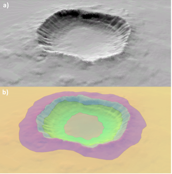
Figure 1: a) The mesh of a crater. b) Regions identified for each assigned material.
Application
As starting case study and validation testing for the framework, we considered to reproduce the future acquisitions of the three SIMBIO-SYS channels, the stereo images of STC (Example in Figure 2), the high-resolution images of HRIC and the hyperspectral cubes of the VIHI channel. The tool will be able to reproduce various realistic scenarios of the BepiColombo mission, creating highly accurate simulated datasets of panchromatic or multi/hyper- spectral acquisitions that will allow us to:
- analyze implications in the planning of SIMBIO-SYS observations on specific targets based on detailed and reliable simulations, verifying how different spectral and spatial details can be resolved with the three channels.
- provide a large, simulated dataset to support development and testing of tools for advance image processing and analysis such as the mosaicking methodologies.
One of the purposes of the developed tool is to support, with the simulated datasets, the planning of SIMBIO-SYS observations on scientific targets, such as the permanent shadowed regions (PSR), hollows, volcanic edifices, and tectonic structures. The analysis of this kind of reliable simulation datasets can provide indications on how different spectral and/or spatial details can be resolved with the SIMBIO-SYS channels. The tool can be very important to the science team involved in the definition of the target to obtain a realistic impression of the future acquisition and drive the temporal planning of such specific features. Disposing of simulated images will provide a direct evaluation of the optimal conditions to satisfy and to constrain during the planning. The tool will open the possibility to perform investigations about the influence of the illumination conditions on the target acquisitions providing invaluable support to planning activities.
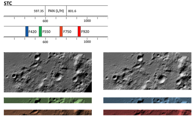
Figure 2: On the top, graphical visualization of the spectral ranges of the STC filters. At the bottom, example of simulated STC acquisitions for both the sub-channels.
References
[1] Cremonese, Gabriele, et al. SIMBIO-SYS: scientific cameras and spectrometer for the BepiColombo mission. Space science reviews, 2020, 216: 1-78.
[2] Penttilä, Antti, et al. Blender modeling and simulation testbed for solar system object imaging and camera performance. No. EPSC2022-788. Copernicus Meetings, 2022.
[3] Acton, Charles H. Nasa’s spice system models the solar system. In: International Astronomical Union Colloquium. Cambridge University Press, 1997. p. 257-262.
How to cite: Re, C., Tullo, A., La Grassa, R., Vergara, N. A., Cremonese, G., and Simioni, E.: PLanetary Image Simulator (PLAS) tool and applications for MPO SIMBIO-SYS camera simulations, Europlanet Science Congress 2024, Berlin, Germany, 8–13 Sep 2024, EPSC2024-851, https://doi.org/10.5194/epsc2024-851, 2024.