
Unsupervised classification of Mercury’s surface to aid the reconstruction of explorative geological maps.
 ,,,,
,,,,- INAF, Astronomical Observatory of Padova, Padova, Italy (cristina.re@inaf.it)
Abstract
This work aims to create the first set of global classification maps of Mercury’ surface that consider both spectral and morpho-stratigraphic properties using unsupervised learning techniques. This represents an ambitious and promising approach for facilitating the generation of comprehensive geological maps.
The efficacy of the clustering framework will be assessed within a well-documented quadrangle of Mercury (H05). Then, following a review of the obtained performance metrics, the approach will be scaled to map the entire surface. The resultant global map will not only complement existing mapped terrains but also serve as an unparalleled tool for unveiling the geological features of regions that remain unexplored, providing an unprecedented tool for planetary geologists.
1. Introduction
The mapping of planetary surfaces represents a fundamental activity in planetary science, offering invaluable insights into the formation history, surface processes, and compositional variations of celestial bodies. Furthermore, accurate and detailed mapping are crucial for tasks ranging from identifying potential landing sites to planning future exploration missions. However, the creation of such maps requires the specialized knowledge of expert planetary scientists and constitutes a time-intensive and highly complex task. In addition, often these maps rely solely on a geomorphology‐led approach overlooking meaningful details about composition (i.e., multispectral data) and physical properties of the defined units, with spectral information usually supplementing rather than informing geomorphological data.
This work aims to create the first set of global, explorative classification maps of Mercury’ surface which incorporate both spectral and morpho-stratigraphic properties using unsupervised learning clustering techniques, representing an ambitious and promising approach for facilitating the generation of comprehensive geological maps.
This classification will facilitate geological interpretation and enhance the mapping of the planet's unexplored regions, while enriching the understanding of already surveyed regions. Such advancements are essential for unraveling the complexities of Mercury's surface, contributing significantly to our understanding of the planet in anticipation of the new wave of data expected from SIMBIO-SYS [1] data on the BepiColombo's mission [2]
2.Methods
The global classification started analyzing Hokusai quadrangle’s DTM [3] and the 8-color map [4]. From this dataset, a suite of derivative maps such as ruggedness, albedo, slope, band ratios and fuse maps will be produced. These maps are designed to highlight those specific terrain/spectral features which are usually used by planetary scientists for constructing geological maps of planetary surfaces. These maps will go through a preliminary phase cleaning and filtering and will be then normalized to organize the data into a coherent framework. After this pre-processing step, produced maps will be classified using 4 different clustering algorithms: k-means, Gaussian Mixture Models, DBSCAN and OPTICS. Clustering performance will initially be evaluated using a set of unsupervised metrics and, given the prior knowledge of the ground truth (e.g., mapped H05), by a set of external metrics. Upon selecting the optimal clustering approach, the resulting classified maps will be compared with existing morpho-stratigraphic and spectral unit maps to determine potential correspondences between the classified and independently defined geological or spectral units. Through this approach, we aim to reconstruct composite units that encapsulate both geological and spectral characteristics, thereby enriching the interpretive value of the clustering results. Finally, the best clustering algorithm will be applied to the entire surface of Mercury to create an explorative map representing morpho-stratigraphic and/or spectral units.
3.Preliminary results
Figure 1 illustrates the preliminary results of initial tests obtained by applying a GMM to a derived raw map of ruggedness (Terrain Ruggedness Index, TRI). The area depicted in the figure, illustrates the NE portion of the H05 quadrangle, and highlights the Rustavelli crater area. Figure 1A shows the available geological map of the zone [5], while figure 1B shows the clustering results from the derived TRI map. The raw TRI map was first normalized using the Z-score method and was classified using GMM. The outputs from this classification evidenced the presence of a “noise” cluster containing background values, that were removed from the classification. Cleaned clustering outputs show 4 different classes (see bottom box for legend) that visually highlight three main types of geomorphological features: (i) Class 1 (Figure 1 C) emphasizes smooth planes and crater floor material; (ii) Class 2 (Figure 1 D) reveals degraded to heavily degraded crater materials as well as crater rims; (iii) Class 3 (Figure 1 E) indistinguishably indicates well-preserved crater material as well as intercrater planes; iv) Class 4 3 (Figure 1 F) detects mainly crater’s rim shapes.
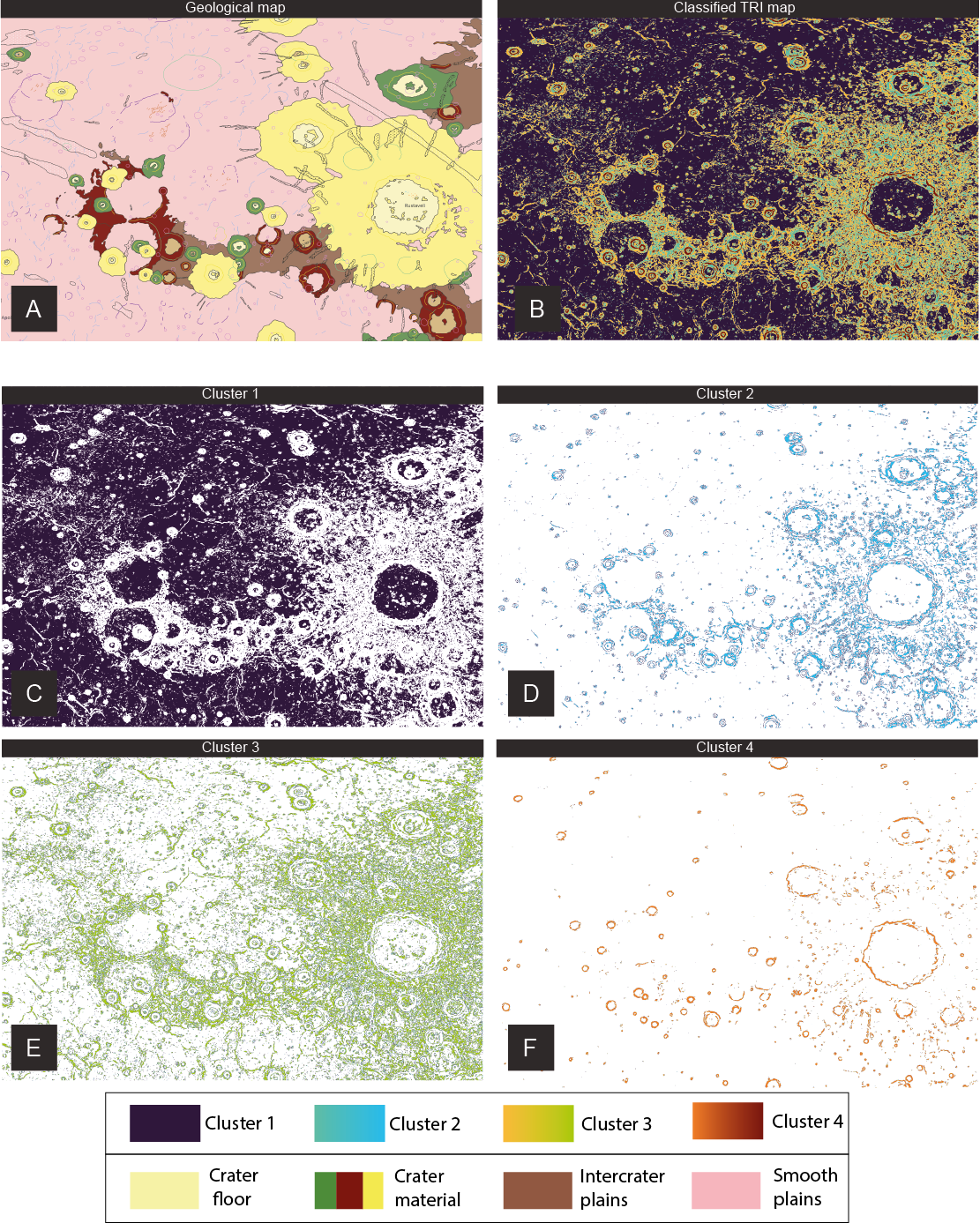
Figure 1. Preliminary clustering results with GMM applied to a TRI map of the NE section of H05 quadrangle, displaying Rustavelli crater. A. Geological map of Rustavelli crater area; B. Map of the clustering outputs showing 4 clusters; C-to-F. Maps of the identified clusters. The bottom box shows the legends for the GMM clustering (upper box) and the simplified geological units (bottom box).
Despite the absence of a performance evaluation step, the preliminary outputs already suggest the great potential of unsupervised methods to recognize geological-related features with a considerable precision. The presented outputs, together with a variety of derived maps, will be tested with different clustering algorithms and will be then evaluated by unsupervised and external metrics to evaluate quantitively the performance of the clustering algorithms.
In a near future, we hope that these exploratory maps will provide planetary geologists with an unprecedented tool for (1) refining the maps of explored terrains and (2) pioneering the mapping of new, unstudied territories by utilizing enhanced data integrating both spectral and geological information.
Acknowledgements: The study has been supported by the Italian Space Agency (ASI-INAF agreement no. 2020-17-HH.0).
References
[1] Cremonese et al. (2020). SIMBIO‐SYS: Scientific cameras and spectrometer for the BepiColombo mission. Space Science Reviews, 216(75), 75; [2] Benkhoff et al. (2021). BepiColombo-mission overview and science goals. Space Science Reviews, 217(8), 90; [3] Becker et al. (2016). First global digital elevation model of Mercury. 47th Lunar and Planetary Science Conference, Houston, TX; [4] Zambon et al. (2022). Spectral units analysis of quadrangle H05‐Hokusai on Mercury. Journal of Geophysical Research: Planets, 127(3), e2021JE006918; [5] Wright et al. (2019). Geology of the Hokusai quadrangle (H05), Mercury. Journal of Maps, 15(2), 509–520.
How to cite: Vergara Sassarini, N. A., Re, C., La Grassa, R., Tullo, A., Spina, L., and Cremonese, G.: Unsupervised classification of Mercury’s surface to aid the reconstruction of explorative geological maps., Europlanet Science Congress 2024, Berlin, Germany, 8–13 Sep 2024, EPSC2024-934, https://doi.org/10.5194/epsc2024-934, 2024.