
 1,1,2,1,
- 1ESTEC - European Space Agency, the Netherlands
- 2Institut für Planetologie, Universität Münster, Germany
Introduction:
The Aristarchus Plateau and the region surrounding it is a promising target for future lunar exploration missions due to its potential for resource utilization and its distinctive geochemical setting. The presence of a prominent thorium anomaly [1] allows the investigation of potential rare earth element (REE) bearing materials by using thorium as a geochemical proxy [1]. In our work, resource potential is assessed through the spatial overlap of elevated thorium, iron, and titanium abundances, while landing suitability is constrained by low slopes and limited surface hazards such as rock abundance. We apply a GIS-based multi-criteria decision (MCDA) analysis, inspired by GIS-based methodological approaches [2], to identify candidate areas where resource-rich materials coincide with favourable landing conditions.
Data and analysis:
For the work presented here, we focussed on identifying regions with high thorium abundance and a low density of boulders. We selected areas with ≥12 ppm thorium to isolate the most geochemically enriched regions within the study area [3]. Areas with high boulder density, defined as 50 or more boulders per pixel (at ~4 km resolution) [4], were excluded as potentially hazardous for landing (Figure 1). Detailed analysis was performed as a raster-based, pixel-level suitability assessment using Clementine-derived titanium and iron abundance (~400 m/px) [5], WAC-derived titanium abundance [6], Kaguya-derived iron abundance (~60 m/px) [7], slope derived from the LRO LOLA - SELENE Kaguya digital elevation model (DEM) (~60 m/px) [8], and Diviner rock abundance (~240 m/px) [9]. Two different titanium and iron datasets were used to improve the robustness of the analysis and reduce uncertainties associated with individual products. For titanium, we used both Clementine- and WAC-derived datasets to balance overestimation in high-Ti maria and detection-limit constraints at low titanium abundances [10].
Table 1: Scoring criteria and weightings used for the landing site suitability analysis
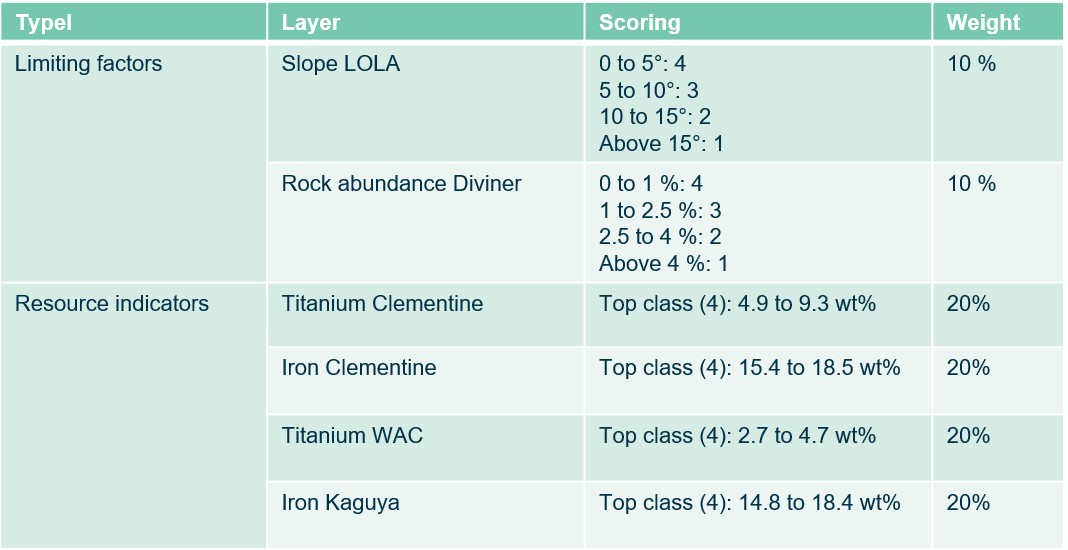
All input layers were transformed into a common simple cylindrical projection and resampled to a spatial resolution of 400 m/px, corresponding to the coarsest input dataset, to ensure alignment of the datasets. The layers were classified into four suitability classes, with scores ranging from 1 (least favourable) to 4 (most favourable). Resource-related indicators were classified using the natural breaks method to emphasize high-value clusters, while limiting factors were categorized based on predefined landing safety thresholds (see Table 1). Resource-related layers were assigned a scoring weight of 20% each, while limiting factors received a weight of 10% each. The weighted layers were then combined using a weighted sum to generate the final suitability map (Figure 1).
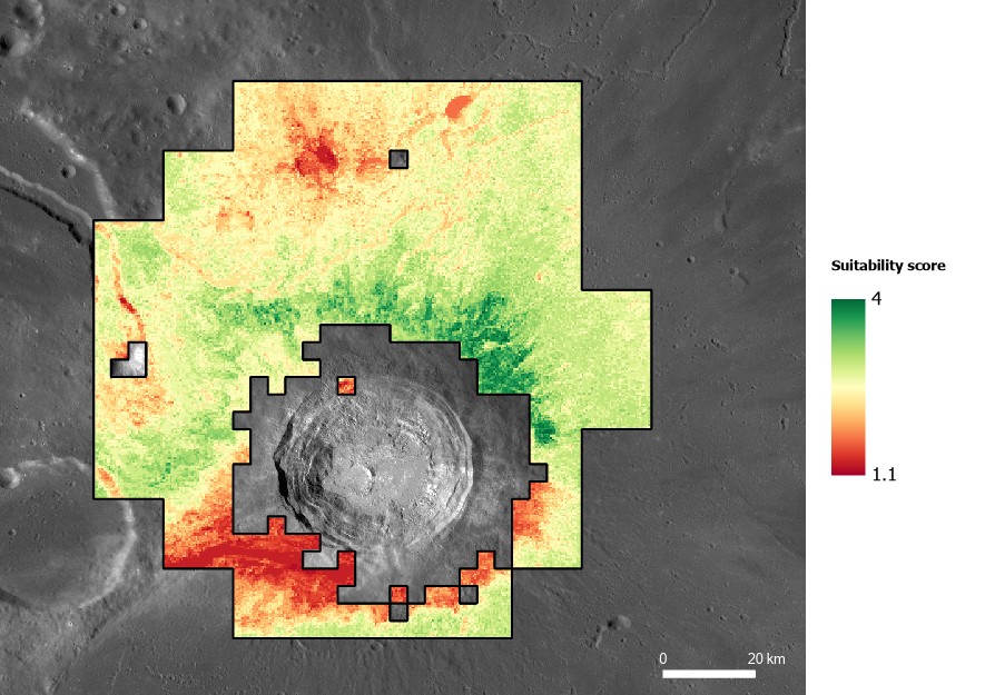
Figure 1: Suitability map for resource prospecting of REEs in the Aristarchus Plateau region, using Th content as a proxy, which is overlaid on a Lunar Reconnaissance Orbiter (LRO) Wide Angle Camera (WAC) global 100 m/px mosaic [13].
Next, pixels reaching the maximum suitability score of 4 were further evaluated. These highest-suitability pixels were converted to points and used for a kernel density estimation to identify the most promising candidate areas. A search radius of 2000 m was applied to identify spatial clusters that represent priority zones for further landing site assessment (see Figure 2).
Results:
The identified hotspots were further evaluated to assess their geological context and local terrain conditions. An overlay with the geological map of Bernhardt et al. (2023) [11] shows that the northernmost hotspot lies approximately 6 km from an irregular mare patch (Figure 2, red cross), adding further scientific value to this candidate area. Although the main suitability analysis was performed at 400 m/px, the identified hotspots were cross-referenced with a high-resolution Kaguya-derived slope layer at ~8 m/px [12]. This confirmed the presence of extensive, continuous areas with slopes below 10° directly beneath the highest-density clusters, indicating locally favourable terrain conditions for potential landing. These zones provide a focused set of priority targets for subsequent high-resolution landing site assessment and demonstrate the usefulness of GIS-based MCDA for resource-oriented lunar exploration planning.
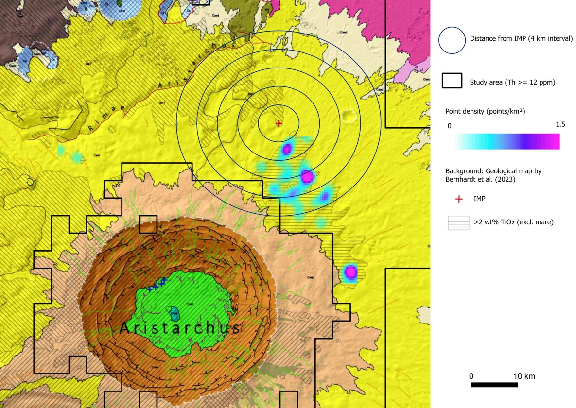
Figure 2: Identified landing hotspots.
References:
[1] Zhang J. & J. Liu (2024) Acta Geochimica 43, 507–519. [2] Waldman A. et al. (2023) Mapping Optimal Landing Sites and Base Locations on the Moon. [3] Glotch T.D. et al. (2021) Planet. Sci. J. 2, 136. [4] Aussel B. et al. (2025) JGR 130, e2025JE008981. [5] Lucey P.G. et al. (2000) JGR Planets 105, 20297–20305. [6] Sato H. et al. (2017) Icarus 296, 216–238. [7] Lemelin M. et al. (2016) LPSC XLVII, Abstr. #2994. [8] Barker M.K. et al. (2016) Icarus 273, 346–355. [9] Powell T.M. et al. (2023) JGR 128, e2022JE007532. [10] Sato H. et al. (2015) LPSC XLVI, Abstr. #1111. [11] Bernhardt H. et al. (2023) LPSC LIV, Abstr. #1104. [12] Haruyama J. et al. (2008) Earth Planets Space 60, 243–255. [13] Robinson M.S. et al. (2010) Space Sci. Rev. 150, 81–124.
How to cite: Tomášková, E., Orgel, C., Oetting, A., Losekamm, M. J., van der Bogert, C. H., Consuma, G., McDonald, F., and Carpenter, J. D.: GIS-Based Multi-Criteria Decision Analysis for Resource-Oriented Landing Site Selection on the Aristarchus Plateau , Europlanet Science Congress 2026, The Hague, The Netherlands, 7–11 Sep 2026, EPSC2026-1011, https://doi.org/10.5194/epsc2026-1011, 2026.


