
 1,3,
1,3,- 1Université de Toulon, Aix Marseille Univ, CNRS, LIS, Marseille, France (firstname.lastname@lis-lab.fr)
- 2IPAG, CNRS, Université Grenoble-Alpes, Grenoble, France (firstname.lastname@univ-grenoble-alpes.fr)
- 3INAF - O.A. di Padova, Padova, Italy (adriano.tullo@inaf.it)
- 4ACRI-ST, Grasse, France (firstname.lastname@acri-st.fr)
Introduction
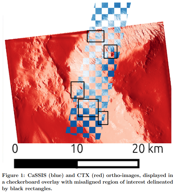
The integration of complementary remote sensing data acquired from multiple satellite platforms represents a fundamental challenge in planetary science, one that has become increasingly critical as mission datasets grow in volume, diversity, and scientific ambition. Addressing this challenge requires two distinct but deeply interconnected steps. Firstly, it demands precise spatial alignment as a critical preprocessing step, ensuring that observations from different instruments can be meaningfully compared and combined. Secondly, the fusion of these data must account for heterogeneous samplings and partially overlapping acquisition footprints, which vary considerably across sensors and orbital geometries. This registration task is particularly demanding for extraterrestrial rocky planets due to several inherent difficulties: the scarcity of distinctive surface features that can serve as reliable landmarks, the absence of ground control infrastructure available on Earth, and significant variations in the spatial coverage between different datasets. As illustrated in Figure 1 with the discrepancy of control points of CTX and CaSSIS data on a ridge of Capri Chasma, these misalignments can be substantial, with spatially offset layers introducing systematic errors that propagate through any downstream scientific analysis, from compositional mapping to geomorphological interpretation.
Methods
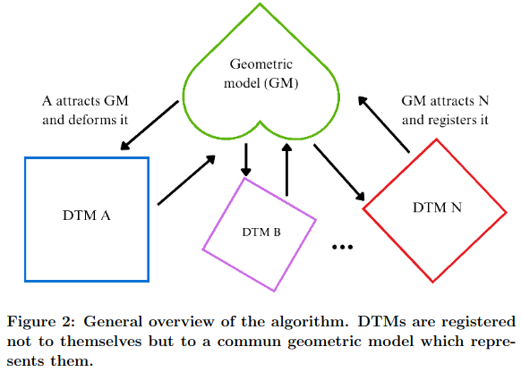
To address these challenges, we propose a novel methodology IReSISD-DTM[1] that leverages three-dimensional topographic information derived from stereo image pairs, specifically utilizing Digital Terrain Models (DTMs). Rather than relying on intensity-based image matching or sparse feature correspondences, our approach exploits the geometric richness encoded in 3D surface representations, making it inherently more robust to the radiometric variability of different acquisitions and textureless regions commonly encountered in planetary imagery. As shown in Figure 2, which provides a overview of the IReSISD-DTM pipeline, our method employs 3D geometric principles to achieve automatic rigid registration between DTMs and subsequently propagated to their associated ortho-images. This enables hands-free, accurate alignment of planetary surface data while simultaneously generating a unified geometric model from the initial DTMs at a user-defined resolution and sampling. This fusion capability is particularly valuable when consolidating datasets of different native resolutions into a single, coherent product suitable for multi-scale analysis or scientific outreach.
Experiments and results
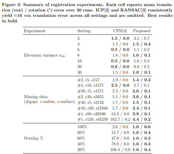
The performance of our method is rigorously evaluated through comparative analysis against both baseline techniques and state-of-the-art registration algorithms and data fusion frameworks. As summarized in Figure 3, which presents our quantitative registration result tables, IReSISD-DTM consistently achieves competitive or superior alignment accuracy across all tested configurations. This evaluation is conducted using two complementary datasets: (1) a newly developed benchmark consisting of synthetic planetary DTMs specifically designed to simulate realistic extraterrestrial terrain conditions, including controlled levels of noise, data gaps, and overlap variation; and (2) actual Martian topographic data acquired by in-orbit sensors (CTX, CaSSIS, and HiRISE) from orbital missions spanning a wide range of spatial resolutions and swath widths.
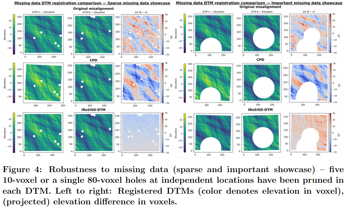
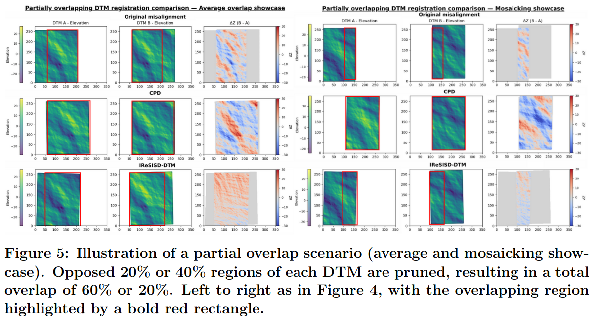
A central finding of this work is that our 3D geometric registration approach achieves satisfactory alignment accuracy while exhibiting significantly enhanced robustness to common remote sensing challenges that severely degrade the performance of conventional methods. Two such challenges are of particular practical importance. The first is incomplete data coverage, arising from sensor occlusions, processing artifacts, or orbital gaps, which introduces missing data regions that undermine correlation-based registration strategies; Figure 4 presents curated examples that highlight how IReSISD-DTM maintains reliable performance even under such conditions. The second challenge is varying degrees of overlap between acquisitions from different orbital passes or instruments; Figure 5 demonstrates, through additional curated examples, that our method sustains accurate registration even when the shared surface area between two datasets is limited, a scenario where all tested SOTA approaches fail entirely.
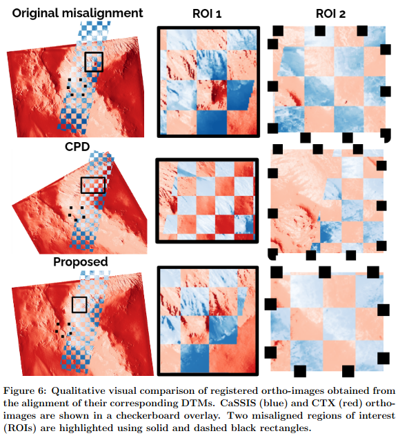
The practical utility of IReSISD-DTM is further demonstrated through its application to three real-world Martian data integration scenarios of increasing complexity. The first involves the registration of a multi-sensor dataset over a cliff face in Capri Chasma, a region of dramatic relief within Valles Marineris, where the precise alignment of high-resolution imagery and topographic products is essential for structural geological analysis; this result is illustrated in Figure 6. The second scenario involves constructing a sparse Martian mosaic over Jezero Crater by aligning orbital observations with heterogeneous coverage patterns. The third and most complex scenario involves a multi-resolution, multi-sensor dataset over Gale Crater, integrating orbital products from CaSSIS, CTX, and HiRISE with in-situ 3D products collected by the Curiosity rover and MOLA point clouds. Together, these case studies establish the versatility and practical relevance of our framework across a wide spectrum of planetary data integration problems.
Conclusion
Our contributions can be summarized along four principal axes: (1) a robust 3D geometric registration framework specifically designed for planetary DTM alignment, capable of operating without manual intervention or ground control points; (2) a customizable fusion method that consolidates the geometric information of multiple DTMs at a resolution and sampling defined by the user; (3) a comprehensive benchmark dataset for the systematic evaluation of planetary surface registration algorithms under controlled and reproducible conditions; and (4) empirical validation demonstrating superior performance in handling footprint-related challenges, including data gaps and limited overlap; compared to existing methods, validated across CaSSIS, CTX, HiRISE, MOLA and Curiosity datasets. Taken together, these contributions advance the state of the art in planetary data integration and lay the groundwork for more automated and scalable multi-mission analysis pipelines.
References
[1] L. Brun, S. Doute, J. Bernard-Salas, and A. Paiement. 3D registration of remote sensing data for planetary exploration. CVPR 2026 Workshop on 3D Geometry Generation for Scientific Computing, 2026.
[2] K. S. Arun, T. S. Huang, and S. D. Blostein. Least-squares fitting of two 3-D point sets. IEEE Transactions on Pattern Analysis and Machine Intelligence (PAMI), 9(5), 1987
[3] M.A. Fischler and R. C. Bolles. Random sample consensus: A paradigm for model fitting with applications to image analysis and automated cartography. Communications of the ACM, 24(6), 1981. 1, 5
[4] Myronenko and X. Song. Point-set registration: Coherent point drift. IEEE Transactions on Pattern Analysis and Machine Intelligence (TPAMI), 32(12), 2010. 2, 5
How to cite: Brun, L., Paiement, A., Douté, S., Tullo, A., and Bernard-Salas, J.: 3D registration and fusion of remote sensing data for planetary exploration, Europlanet Science Congress 2026, The Hague, The Netherlands, 7–11 Sep 2026, EPSC2026-1040, https://doi.org/10.5194/epsc2026-1040, 2026.


