
 ,,
,,- DLR, Institute of Planetary Research, Planetary Geology, Berlin, Germany (isuyazici@gmail.com)
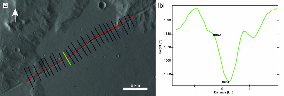
Figure 1: Topographic profiles for fault scaling. (a) the black line shows the longitudinal fault profile, the red lines are the individual cross-sections, and the green line shows the exemplary cross-section profile in (b), in which the minimum and maximum elevations at the graben floor and shoulders, respectively, are marked by green dots.
While HRSC profiles provided a regional overview of displacement scaling, the resolution was insufficient for a very small-scale analysis of segment boundaries. Consequently, we performed detailed structural mapping on 12 representative faults using high-resolution CTX imagery (~5-6 m/pixel). This approach enabled the identification of features such as relay ramps and linkage points. We classify segment hierarchies and evaluate the mechanical continuity of the fault network.

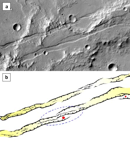
Figure 3: Parallel, long and narrow grabens typical for the Memnonia Fossae fault population. Note the linkage of faults in the area marked by the blue dashed line, and the relay ramp separating two fault segments (red dot). Detail of image mosaic of CTX images P13_005956_1569 and F23_044684_1565 (center at 22.12°S, 205.11°E).
We compare our results to previous measurements of faults on Mars, Earth, and beyond. Based on these analyses, we discuss the implications of fault segmentation and linkage for further interpretation.
Results
The initial analysis of 100 faults yielded an average Dmax/L ratio of 0.007, consistent with previous measurements of extensional systems of Mars [10]. The use of HRSC data allowed for a more precise determination of maximum displacement locations.
The subsequent comprehensive segmentation analysis of 12 faults demonstrates that the Memnonia region is organized into a clear hierarchical structure. While the number of primary segments remains relatively consistent across the population, segment lengths vary significantly between individual faults. Longer faults exhibit a higher number of hierarchical ranks, whereas smaller faults are composed of fewer subdivisions. Each sub-segment group typically contains two to three lower-hierarchy segments within each rank. These findings suggest that the present-day grabens are the product of systematic coalescence, where segment linkage plays a defining role in the distribution of strain (Fig. 2). The identified segment hierarchies provide a kinematic record of fault maturation, indicating that the current fault architecture is a product of progressive segment integration rather than isolated fracture growth.
References
[1] Cartwright, J. A., et al., J. Struct. Geol. 17, 1319-1326, 1995. [2] Cowie, P. A., Scholz, C. H. J. Struct. Geol. 14(10), 1149-1156, 1992. [3] Schultz, R.A. et al. J. Struct. Geol., 32, 855-875, 2010. [4] Cowie, P.A. and Scholz, C.H., J. Struct. Geol. 14, 1133-1148, 1992. [5] Peacock, D. C. P. J. Struct. Geol. 13(9), 1025-1035, 1991. [6] Stähler, S. C., et al. Nature Astronomy, 6(12), 1376-1386, 2022. [7] Perrin, C., et al., J. Geophys. Res., 127(1), e2021JE007118, 2022. [8] Lognonné, P., et al., (2019) Space Science Reviews, 215(1), 1-70. [9] Gwinner, K. et al. (2010) Earth Planet. Sci. Lett., 294, 506-519. [11] Hauber, E. et al. (2014) Lunar Planet. Sci. Conf. 45, #1981.
How to cite: Yazıcı, I. S., Hauber, E., and Tirsch, D.: Fault geometry analysis of Memnonia Fossae, Mars, Europlanet Science Congress 2026, The Hague, The Netherlands, 7–11 Sep 2026, EPSC2026-1098, https://doi.org/10.5194/epsc2026-1098, 2026.


