
 ,
,- Fondazione Bruno Kessler, Trento, Italy
Characterizing the planetary subsurface through Radar Sounder (RS) data is fundamental to reconstructing the evolutionary history of the Solar System. However, the increasing volume of RS archives, which will be further expanded by upcoming and prospective missions to the Jovian and Uranian icy moons, necessitates a shift toward automated extraction methods. Although recent machine learning applications in RS stratigraphy have successfully automated the detection of isochronous layers, a significant methodological gap remains in detecting localized non-horizontal reflections. Features such as Martian troughs and Trough Migration Paths (TMPs) can serve as analogs for oblique geometries. Troughs are migratory valleys in the Martian North Polar Layered Deposit (NPLD), and their evolution provides a unique record of the history, including katabatic winds, sublimation, and cyclical climate forcing [1]. Their historical migration is encoded in the subsurface as Trough Migration Paths (TMPs), which are morpho-stratigraphic unconformities that truncate isochronous layers and track the trough floor over geological timescales [1]. While the joint analysis of high-resolution optical imagery (HiRISE/CTX) and RS (SHARAD) is essential for mapping these features [1], it relies heavily on manual tracing, which limits scalability.
We frame the detection of dipping targets considering troughs and TMPs as analogues in RS data as a semantic segmentation task stratigraphy). We introduce a two-stage deep learning strategy based on a physics-informed contrastive pre-training phase, followed by supervised fine-tuning that mitigates class imbalance between troughs, TMPs, and horizontal stratigraphy. For the pre-training stage, we utilize a Momentum Contrast (MoCo) framework. MoCo forces a network to learn discriminative feature representations by maximizing the similarity between distinct views of the same image [2]. However, rather than relying on computer vision augmentations, we leverage squinted Synthetic Aperture Radar (SAR) focusing to generate physically consistent views of the same subsurface at distinct squint angles [3]. This forces the network to learn latent structural representations that are strictly invariant to angle-dependent radiometry. This approach desensitizes the model to the overwhelmingly dominant horizontal stratigraphy of the Martian polar regions, enabling it to capture the dipping signatures of troughs and TMPs without human supervision. The model is fine-tuned on a limited set of labeled radargrams for trough and TMPs. To prevent the model from being biased by dominant horizontal stratigraphy, we use a weighted binary cross-entropy loss function. Finally, detected troughs and TMPs are georeferenced and integrated into an interactive geospatial interface. Beyond simply visualizing the regional distribution of troughs and TMPs, this interface facilitates the geomorphological analysis. The interface allows users to navigate to the original radargrams for detailed morphological analysis, including depth and steepness of the trough walls and the TMPs.
We consider SHARAD Experimental Data Record (EDR) radargrams acquired over the Martian NPLD (latitude > 77.5 N) between 2007 and 2021during solar occultation, yielding a set of 488 radargrams [4]. These were SAR-focused with 11 distinct squint angles that capture the diverse geometric slopes of the targets [3]. The data were partitioned into coregistered 11-channel patches (256×256 pixels) and standardized. The contrastive pre-training dataset comprises 1519 patches (split 70% for training, 15% for validation, and 15% for test). For the fine-tuning phase, experts annotated 50 radargrams (yielding 210 patches split 70% for training, 15% for validation, and 15% for test), cross-referencing with cluttergrams to decouple off-nadir clutter and subsurface reflections.
Applying the proposed deep learning method to the SHARAD dataset yielded an automated map of the Martian NPLD troughs and TMPs. The model successfully isolated the troughs and TMPs from the dominant background stratigraphy, automatically detecting more than 95% of them across the NPLD. Figure 1 displays the results projected onto a polar Digital Elevation Model (DEM), where blue tracks indicate the spatial extent of TMPs and red markers denote the troughs. The geographical distribution of troughs and TMPS over the NPLD aligns with the spiral pattern. The interactive geospatial interface links the regional map to radargrams (Figure 2). Selecting map features displays the corresponding radargrams overlaid with a segmentation map that delineates the V-shaped topography of the troughs (Figure 2, left) and the stratigraphic interruptions in the TMPs (Figure 2, right). The segmentation enables automated extraction of morphological metrics, such as average trough depth and wall steepness. The extracted values are consistent with measurements reported in the literature [1].
This work presents a dual-stage training methodology that leverages the physics of the dipping targets to map through and TMPS in RS data. We also deliver a geospatial interface that links the target's geographic position to the radargram. The methodology can be extended, with appropriate modifications, to map and characterize other geological dipping targets, including subsurface faults on Jovian or Uranian moons, providing a robust tool for investigating the cryotectonic evolution of icy satellites.
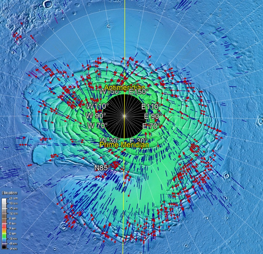
Figure 1: Map with the track of the radargram portions imaging TMPs in blue and the position of the deepest point of the troughs in red.
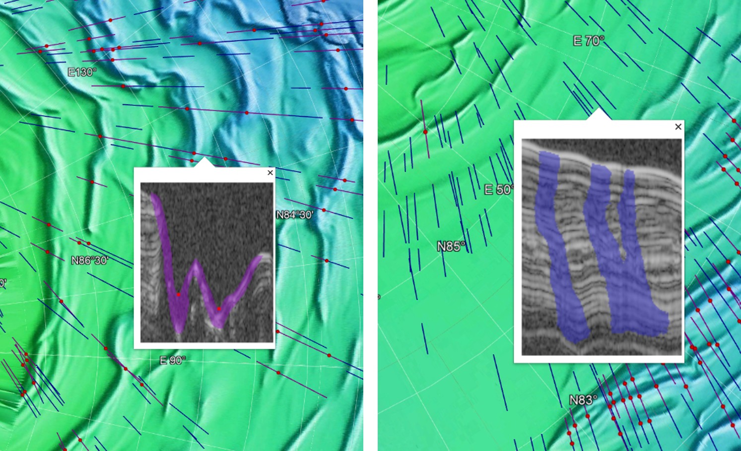
Figure 2: Example of trough (on the left) and TMPs (on the right) detected by the proposed method and visualized in the geospatial interface.
References
- Smith, I. B., and J. W. Holt. "Onset and migration of spiral troughs on Mars revealed by orbital radar." Nature, 2010.
- He, K., et al. "Momentum contrast for unsupervised visual representation learning." Proceedings of the IEEE/CVF conference on computer vision and pattern recognition. 2020.
- Ferro, A. "Squinted SAR focusing for improving automatic radar sounder data analysis and enhancement." International Journal of Remote Sensing
- Donini, E., et al. "Deep learning for unsupervised denoising of radar sounder data." IGARSS 2023-2023 IEEE International Geoscience and Remote Sensing Symposium.
- Donini, E., F. Bovolo, and L. Bruzzone. "A deep learning architecture for semantic segmentation of radar sounder data." IEEE Transactions on Geoscience and Remote Sensing
How to cite: Donini, E., Mitton, G., and Bovolo, F.: A Deep Learning Method for Mapping Dipping Subsurface Features, Europlanet Science Congress 2026, The Hague, The Netherlands, 7–11 Sep 2026, EPSC2026-1141, https://doi.org/10.5194/epsc2026-1141, 2026.


