
 ,
,- Fondazione Bruno Kessler, Trento, Italy
Ongoing planetary missions and future endeavors, such as JUICE to the Jovian moons, EnVision to Venus, and envisioned missions to the moons of Uranus, highlight the growing importance of Radar Sounders (RSs) for planetary science. RSs are active remote sensors capable of imaging dielectric discontinuities in the subsurface and recording them in depth images known as radargrams. While manual radargram analysis has led to important discoveries, such as the evolution of Martian troughs [1], efficiently exploiting the increasingly vast RS datasets necessitates automated methods. Currently, most automated approaches focus on segmentation or detection of linear reflections, yet there remains a need for methods that can analyze and semantically aggregate radargrams performing a large scale analysis.
We conduct large scale analysis by leveraging on Martian RS data as a primary planetary analogue for future planned and envisioned missions to the icy moons of Jupiter and Uranus. We utilize Shallow Radar (SHARAD) data [5] acquired over the North Polar Layered Deposits (NPLD) (latitude > 77.5°). SHARAD achieves a vertical resolution of about 15 m in vacuum with a maximum penetration of about 1 km [6]. At the NPLD, SHARAD images icy targets, characterized by horizontal stratigraphy and oblique structures, that closely resemble the data expected from future and envisioned RS missions. Our analysis focuses on mapping troughs, which are depressions following a spiral pattern with depths of 400-1000 m [1]. Troughs expose the NPLD internal stratigraphy and record Martian climate processes within the Trough Migration Paths (TMPs). TMPs are subsurface unconformities that trace the trough displacement since their formation [2]. Their development followed distinct evolutionary paths across eight geographical regions, each characterized by unique morphological traits of TMPs and troughs.
We selected 488 EDR SHARAD radargrams that are processed with squinted SAR focusing [7]. This approach optimizes the detection of non-horizontal reflections by aligning the RS line of sight with the subsurface dipping interfaces, such as trough walls and TMPs, which might otherwise be poorly resolved. We consider 11 squint angles, ranging from -2.5° to +2.5° in 0.5° steps. Radargrams are partitioned into patches of dimension 512 x 128 x 11, in the range, azimuth, and squint angle directions, and are divided into training and validation sets of 6,871 and 2,017 patches, respectively. Each patch is linked to one of the NPLD region [3] based on the morphological characteristics of the troughs and TMPs in the patch.
Given a query radargram imaging a trough and/or a TMP, the goal is to retrieve radargrams with similar geological signatures, enabling the mapping of known and previously uncharacterized troughs and TMPs across the NPLD [3]. The task is addressed using the Content-Based Image Retrieval (CBIR) method in [4], where a Masked Autoencoder (MAE)[8], composed of a Vision Transformer (ViT) encoder [9] and a lightweight decoder, is trained in a self-supervised manner using a reconstruction proxy task. By reconstructing missing parts of the radargrams from their surrounding context, the model learns compact embeddings that encode the morphology of troughs, horizontal stratigraphy, and TMPs. Multi-squint radargrams are incorporated as input channels, providing the network with a physics-aware and multi-view representation that enhances oblique features. In inference, the pre-trained encoder maps each radargram into an embedding space where those with similar surface and subsurface signatures are grouped together. Retrieval is performed by ranking all embeddings in the validation set by cosine similarity with the selected query.
The proposed method achieves a mean Average Precision (mAP) of 67.15% across the eight regions on the validation set. Figure 1 shows a representative query from region 5 and its five most similar retrievals, which exhibit trough and TMP patterns consistent with those of the query. Figure 2 presents maps of 15 representative trough queries from NPLD regions 3 and 7, together with their top-5 retrievals projected onto the MOLA topographic map. Most retrievals cluster within the corresponding query region, indicating that the method captures region-specific trough and TMP characteristics. Misretrievals mainly occur near region boundaries, likely reflecting both annotation uncertainty and similarity between geological features across adjacent regions.
The results demonstrate that the proposed method facilitates large-scale subsurface mapping of troughs and TMPs by efficiently processing vast RS datasets. The method distinguishes between subtly different trough and TMP morphologies, effectively categorizing them in the distinct regions. This approach provides a tool for the large-scale analysis of subsurface data, supporting the management of the vast datasets expected from future and envisioned missions to the icy moons of Jupiter and Uranus. In these contexts, where specific geological targets may be unknown, grouping them by semantic similarity helps identify recurrent subsurface features.
Figure 1: Query radargram and five most similar retrievals from Region 5.
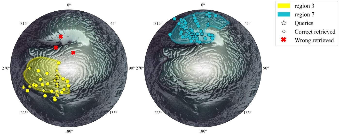
Figure 2: Retrieval maps for NPLD regions 3 and 7. Queries (stars), correct retrievals (circles), and incorrect retrievals (crosses) are shown.
References
[1] Smith, I. B., et al. (2013), The spiral troughs of Mars as cyclic steps, J. Geophys. Res. Planets, 118.
[2] Smith, I., Holt, J. (2010), Onset and migration of spiral troughs on Mars revealed by orbital radar, Nature, 465.
[3] Smith, I. B., and J. W. Holt (2015), Spiral trough diversity on the north pole of Mars, as seen by Shallow Radar (SHARAD), J. Geophys. Res. Planets, 120.
[4] Donini, E., et al. (2026), A deep learning method for dual-frequency radar sounder data retrieval, in Proc. IEEE Int. Geosci. Remote Sens. Symp. (IGARSS).
[5] Seu, R.,et al. (2007), SHARAD sounding radar on the Mars Reconnaissance Orbiter, J. Geophys. Res., 112.
[6] Croci, R., et al. (2011), The Shallow Radar (SHARAD) on board the NASA MRO mission, Proceedings of the IEEE, vol. 99.
[7] Ferro, A. (2019), Squinted SAR focusing for improving automatic radar sounder data analysis and enhancement, International Journal of Remote Sensing.
[8] He, K., X. Chen, S. Xie, Y. Li, P. Dollár, and R. Girshick (2022), Masked autoencoders are scalable vision learners, IEEE/CVF Conference on Computer Vision and Pattern Recognition (CVPR).
[9] Dosovitskiy, A., et al. (2021), An image is worth 16x16 words: Transformers for image recognition at scale, International Conference on Learning Representations (ICLR)
How to cite: Borsi, S., Donini, E., and Bovolo, F.: Towards Large-Scale Mapping of Subsurface Targets: Case Study of Spiral Troughs, Europlanet Science Congress 2026, The Hague, The Netherlands, 6–11 Sep 2026, EPSC2026-1165, https://doi.org/10.5194/epsc2026-1165, 2026.


