
 2,2
2,2- 1Università Gabriele d'Annunzio Ud’A, Viale Pindaro 42, 65127 Pescara, Italy (alberto.pulvirenti99@gmail.com)
- 2European Space Agency (ESA), European Space Research and Technology Centre (ESTEC), Keplerlaan 1, 2201 AZ Noordwijk, The Netherlands (elliot.sefton-nash@esa.int)
Introduction
Elongated craters on Mars represent a unique class of geological features formed by very low-angle impacts, typically below 10-15° from the horizontal. According to the ‘Moonlets Decay Hypothesis’, some ancient impact structures may have originated from the orbital decay of multiple moonlets formed from an equatorial debris disk generated by a giant impact, such as that thought to have resulted in the formation of Phobos and Deimos [1,3,5]. Thus, this work pursues two main goals: (i) building a database of already identified Martian elongated craters that contains additional morphological measurements (of ejecta, rim) and derived geometric properties (azimuth), and (ii) introducing a new methodology to constrain the direction of impact by investigating the depth variation of the crater floor, hereafter referred to as Deepest Point (DP) analysis.
Updated Database
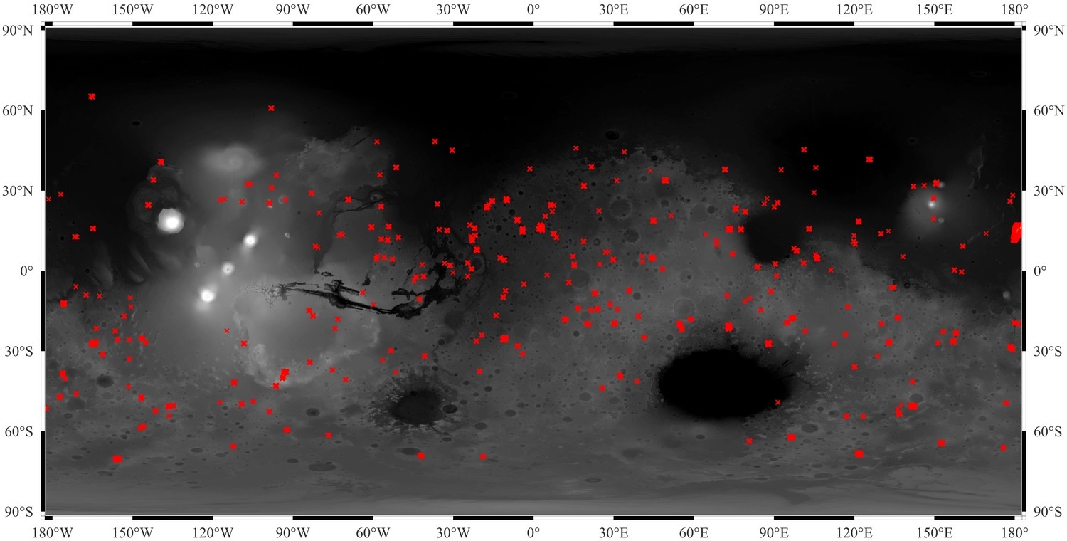
We performed a systematic revision of prior efforts [8, 9] using CTX imagery acquired by NASA's MRO spacecraft, which provides significantly higher resolution than the Viking and HRSC images used in previous versions [1,2,3]. This procedure led to the removal of 46 misidentified features, including non-impact landforms such as irregular depressions, fractured zones, and double circular impact structures. After identifying and adding new valid craters, this new version of our database consists of 306 craters, covering latitudes from +65° to −65°. Each entry is associated with at least 24 descriptive attributes, including coordinates, ellipticity, azimuthal orientation, degradation level (DL), crater type, ejecta morphology, and deepest point measurements. The Robbins & Hynek (2012) global crater database [6] served as an additional validation tool.
Deepest Point Analysis
Previous studies and laboratory experiments [4,7] have demonstrated that from the sole post-impact distribution of the ejected material, it is possible to retrieve the direction from which the impactor came. We aim to provide the deepest point methodology for further constraining and/or confirming the impact direction from the analysis of the depth variation of the crater floor along its major axis.
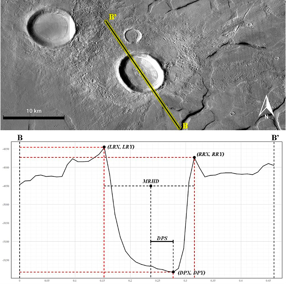
During the systematic data collection for each crater in the renewed database, a measurable rim-to-floor elevation difference along the major axis was identified, with the deepest point consistently shifted toward the crater downrange. The deepest point is assumed to be the best approximation of the lowest area of the crater floor, representing a morphological signature not previously exploited as an independent directional indicator.
Using the MOLA DEM (1px/463m), topographic profiles were traced and extracted along the major axis of selected craters in QGIS. For each profile, the positions of both rims and the DP were recorded, and the Deepest Point Shift (DPS) was measured relative to the geometric crater center. A normalization procedure (left rim = 0, center = 0.5, right rim = 1) was applied to enable size-independent comparison. Selection criteria included: recent craters (degradation level DL = 1–2), single-impact morphology [6], major axis > 7 km, absence of a linear central peak, and presence of a clearly identifiable forbidden zone. A subset of 10 older craters was included for comparison. The final sampling consists of 56 craters.
Results
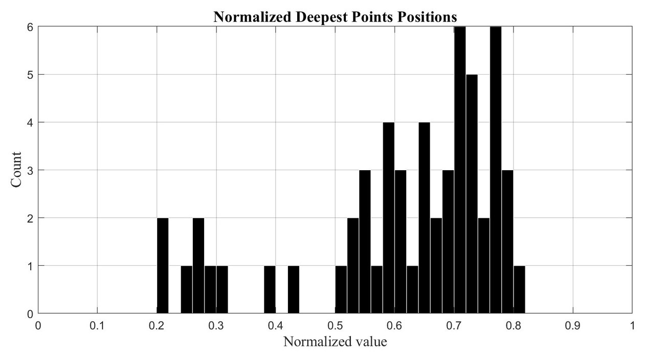
Among the 56 craters analyzed, 47 recent craters (RC) show a DP shifted toward the crater downrange, contrary to numerical predictions [4,7], yielding a reliability rate of approximately 85% (40 correct vs. 6 inconsistent), compared to ~58% for the 10 older craters (OC). These results confirm that the deepest point is a statistically robust directional indicator, mainly for well-preserved elongated craters.
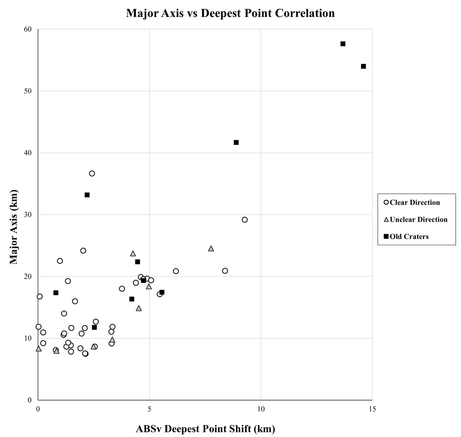
Moreover, we distinguished craters into: (i) clear direction (constrained by well-preserved ejecta distribution), (ii) unclear direction (limited by resolution or degradation), and (iii) old craters (with intrinsically higher directional uncertainty and degradation state).
The correlation between DPS and crater major axis reveals a direct proportionality: the larger the crater, the greater the shift from the crater's center. No significant correlation was found between DPS and ellipticity alone, confirming crater size as the dominant control. Regarding impact angle, a rough correlation is observed between shallower impacts and absolute DPS values, but strong limitations were found due to the estimation of impact angles.
Conclusion
Revising the latest database and adding new features were fundamental steps to accurately distinguish and classify elongated craters in the new catalog version. Additionally, the deepest point finding demonstrates that the crater floor topography of elongated craters preserves a measurable record of impactor trajectory, providing a new morphological tool complementary to the traditional ejecta-distribution-based method. Numerical simulations and experimental analyses are necessary to better understand oblique impact processes and the crustal response at different impact angles.
References
[1] Schultz, P. H. and Lutz-Garihan, A. B.: Grazing Impacts on Mars: A Record of Lost Satellites, Journal of Geophysical Research, Vol. 87, pp. 84-96, 1982.
[2] Barlow, N. G.: Crater Size-Frequency Distributions and a Revised Martian Relative Chronology, Icarus, Vol. 75, pp. 285-305, 1988.
[3] Bottke, W. F., Love, S. G. and Tytell, D.: Interpreting the Elliptical Crater Populations on Mars, Venus and the Moon, Icarus, Vol. 145, pp. 108-121, 2000.
[4] Anderson, J. L. B., & Schultz, P. H. (2006, March). Flow-field center migration during oblique impacts: Implications for curved uprange ejecta rays. In 37th Annual Lunar and Planetary Science Conference (p. 1726).
[5] Craddock, R. A. (2011). Are Phobos and Deimos the result of a giant impact? Icarus, 211(2), 1150–1161
[6] Robbins, S. J., & Hynek, B. M. (2012). A new global database of Mars impact craters ≥1 km: 1. Database creation, properties, and parameters. Journal of Geophysical Research: Planets, 117(E5), 2011JE003966
[7] Elbeshausen, D., Wünnemann, K., & Collins, G. S. (2013). The transition from circular to elliptical impact craters. Journal of Geophysical Research: Planets, 118(11), 2295–2309
[8] Sefton-Nash, E., Faes, Z., Witasse, O., & Buchenberger, B. (2019). Alignment of Mars Elongated Crater Azimuths with Orbit Planes Representing Paleo-Equators. In 50th Annual Lunar and Planetary Science Conference (p. 3252).
[9] Buchenberger, B., Sefton-Nash, E., & Witasse, O. (2021). Analysis of topographic profiles of elongated craters on Mars. In European Planetary Science Congress (pp. EPSC2021-492).
How to cite: Pulvirenti, A., Sefton-Nash, E., and Witasse, O.: An Updated Database of Elongated Craters on Mars: Revised Population, New Attributes, and Deepest Point Analysis, Europlanet Science Congress 2026, The Hague, The Netherlands, 7–11 Sep 2026, EPSC2026-121, https://doi.org/10.5194/epsc2026-121, 2026.


