EPSC Abstracts
Vol. 19, EPSC2026-1344, 2026, updated on 02 Jul 2026
https://doi.org/10.5194/epsc2026-1344
Europlanet Science Congress 2026
© Author(s) 2026. This work is distributed under the Creative Commons Attribution 4.0 License.

Design and performances of a radar-based orbit determinationconcept aimed at Enceladus
 2,3,4,2,4,4,1,
- 1Institute of Microwaves and Photonics (LHFT), Friedrich-Alexander- Universität Erlangen-Nürnberg (FAU), 91058 Erlangen, Germany
- 2Microwaves and Radar Institute, German Aerospace Center (DLR), 82234 Weßling, Germany
- 3Institute of Geodesy and Geoinformation Science, Technische Universität Berlin, Berlin 10553, Germany
- 4Institute of Space Research, German Aerospace Center (DLR), 12489 Berlin, Germany
As a Saturnian satellite featuring a subsurface ocean, Enceladus stands as a primary target for
upcoming exploratory missions aimed at identifying habitable environments and biological signatures.
Building upon Cassini-Huygens, future missions are targeting the Saturnian moon, notably the L4 ESA
mission expected to be launched in the early 2040s.
Within DLR’s Enceladus Explorer (EnEx) initiatives, the RaTNOS (Radar Transponder based Navigation
and Orbit Determination for Satellites) project is aimed at assessing a mission concept based on an
orbiter with a radar instrument as payload and one or multiple small landers with radar transponder
functionalities. Leveraging high-accuracy ranging and Doppler measurements between the orbital radar
and the small landers on the surface, the system is expected to provide improved orbit determination
compared to Earth-based range and Doppler measurements, while offering the option for radar
mapping of the moon’s surface and subsurface. For a mission to Saturn and its moons, the expected
accuracy achievable with standard Earth-based measurements is in the range of tens to a few hundreds
of meters, which greatly limits the potential for geophysical analysis and science. Specifically, the
proposed radar link between orbiter and lander may enhance navigation precision and mission
capabilities, directly improving the accuracy of scientific data products. Beyond the direct impact on
gravity measurements, the improved orbit determination may significantly improve coherent radar
imaging modes such as Synthetic Aperture Radar (SAR) imaging, repeat-pass interferometry, and tomography [1, 2, 3]. In particular, repeat-pass radar interferometry and tomography, enabling high-
resolution Digital Elevation Model (DEM) generation, volumetric imaging of Enceladus’s upper ice shell, alongside precise deformation mapping of the surface, may greatly benefit from improved orbit determination.
The proposed concept builds upon previous EnEx initiatives that analyzed the use of transponder
systems on melting probes for precise localization. The employment of ice-buried radar transponders
enables a novel suite of measurements, including refined characterization of ice and snow dielectric
properties, bulk density, grain morphology, and three-dimensional scanning of the surface ice and snow
layers [4, 5]. These advantages are not mission-specific; they apply to any orbiter-lander platform
equipped with radar payloads.
The prototype transponder system is currently being developed and tested using DLR’s airborne radar
sensor F-SAR and the German radar satellite TerraSAR-X. To facilitate potential surface deployment on
Enceladus, the design of the radar transponders targets a highly compact form factor. The transponder
prototype is capable of operating at different frequencies, specifically within the L- to X-band range [6],
to allow performance assessments for different radar systems. The system employs a bistatic acquisition
geometry in which the transponder receives, records, amplifies, and retransmits signals from the radar
sensor (spaceborne or airborne). By configuring the retransmission delay, the system enables active
clutter mitigation in the processed radar data, thereby enhancing tracking accuracy. Beyond supporting
orbit determination functionalities, the transponder signatures can potentially be used for radiometric
and geometric calibration of the radar system, improving, for example, backscatter measurements.
The potential performance of the proposed system consisting of an orbital radar system and
transponders on the Enceladus surface is further evaluated by end-to-end radar data simulations,
utilizing a 30 m-resolution Digital Elevation Model (DEM) of Enceladus and a suitable backscatter model
as clutter background, as well as the radar carried by an orbiter on a stable repeat-pass orbit around
the moon [3, 7, 8]. The potential for inverting snow and ice volume parameters for a transponder located within the ice (e.g., on an ice-penetrating melting probe) was demonstrated using airborne L-
band radar data collected over the Aletsch Glacier in Switzerland as an Earth analog [9, 10]. Analysis of these datasets already demonstrates that centimeter-level ranging accuracy is achievable, alongside snow and ice parameter estimation.
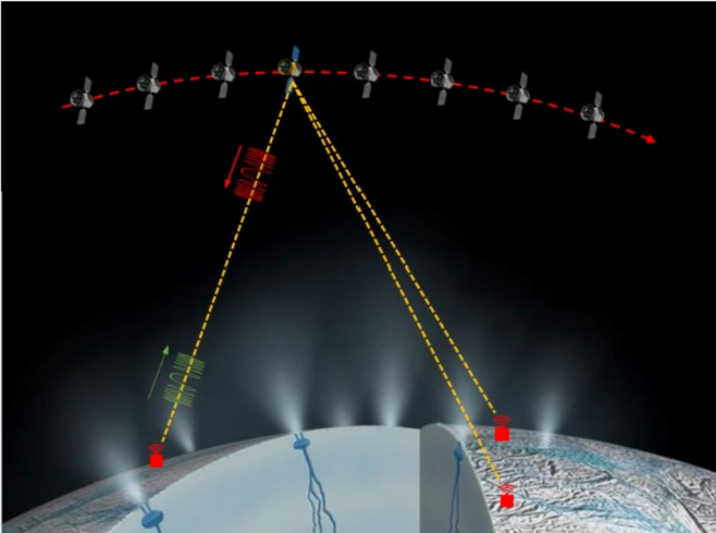
Figure 1. Schematic illustration of the EnEx-RaTNOS mission concept
References
[1] M. Simons, B. Anderson, A. Benedikter, S. Bhaskaran, A. Berne, S. Horst, et al., “Crustal
deformation derived from repeat-pass interferometric SAR at Enceladus – why and how?”,
Bulletin of the AAS, vol. 55, no. 8, 2023.
[2] P. A. Rosen et al., “Repeat Pass InSAR at Enceladus: A Geophysics Mission Concept to
Understand Dynamics and Habitability”, 15th European Conference on Synthetic Aperture
Radar (EUSAR), Munich, Germany, 2024, pp. 1318–1323.
[3] A. Benedikter et al., “Periodic orbits for interferometric and tomographic radar imaging of
Saturn’s moon Enceladus”, Acta Astronautica, vol. 191, pp. 326–345, 2022.
[4] A. Benedikter, C. Huber, L. Gambacorta, M. Rodriguez-Cassola, and G. Krieger, “Travel Time
Computation in Snow and Ice Volumes for Radar Remote Sensing Applications”, IEEE
Microwave and Wireless Components Letters, vol. 32, no. 3, pp. 249–252, 2022.
[5] L. Gambacorta, A. Benedikter, M. Jäger, V. Marx, C. Huber, M. Stelzig, M. Rodriguez-Cassola,
and G. Krieger, “Estimating Ice Permittivity via Travel Time Analysis of Airborne Radar Data from
Buried Transponder Signatures”, 16th European Conference on Synthetic Aperture Radar
(EUSAR), Baden-Baden, Germany, 2026 (under press).
[6] V. Marx et al., “System Concept of a Digital, Reconfigurable Multiband Radar Transponder
for SAR Reference Use”, 17th German Microwave Conference (GeMiC), Karlsruhe, Germany,
2026, pp. 129–132, doi:10.1109/GeMiC71240.2026.11516434.
[7] M. Rodriguez-Cassola et al., “End-to-end Level-0 Data Simulation Tool for Future
Spaceborne SAR Missions”, 12th European Conference on Synthetic Aperture Radar (EUSAR),
Aachen, Germany, 2018, pp. 1–6.
[8] R. S. Park, N. Mastrodemos, R. A. Jacobson, A. Berne, A. T. Vaughan, D. J. Hemingway, and
S. Vance, “The global shape, gravity field, and libration of Enceladus”, Journal of Geophysical
Research: Planets, vol. 129, no. 1, e2023JE008054.
[9] R. Horn et al., “F-SAR – Recent upgrades and campaign activities”, 18th International Radar
Symposium (IRS), Prague, Czech Republic, 2017, pp. 1–10, doi:10.23919/IRS.2017.8008092.
[10] M. Stelzig et al., “Virtual Synthetic Aperture Radar Target Based on a Miniaturized
Monostatic Digital Delay Transponder”, IEEE Microwave and Wireless Components Letters, vol.
32, no. 3, pp. 249–252, 2022.
How to cite: Gambacorta, L., Benedikter, A., Neumann, W., Marx, V., Stark, A., Jäger, M., Hußmann, H., Wickhusen, K., Cassola, M.-R., Oberst, J., Vossiek, M., and Krieger, G.: Design and performances of a radar-based orbit determinationconcept aimed at Enceladus, Europlanet Science Congress 2026, The Hague, The Netherlands, 7–11 Sep 2026, EPSC2026-1344, https://doi.org/10.5194/epsc2026-1344, 2026.


