Multiple terms: term1 term2
red apples
returns results with all terms like:
Fructose levels in red and green apples
Precise match in quotes: "term1 term2"
"red apples"
returns results matching exactly like:
Anthocyanin biosynthesis in red apples
Exclude a term with -: term1 -term2
apples -red
returns results containing apples but not red:
Malic acid in green apples
hits for "" in
Network problems
Server timeout
Invalid search term
Too many requests
Empty search term
MITM2
Comet Interceptor (Comet-I) is the first Fast track development mission (F1) in ESA’s Cosmic Vision 2015-2025 Programme, selected in June 2019. The mission aims to perform multi-point observations to characterize a yet-to-be-identified comet. All space missions to comets so far have visited short-period comets (SPCs). Comet Interceptor will, for the first time, target a long-period comet (LPC), ideally a dynamically new one (DNC) or even an Interstellar Object (IO).
The mission will investigate the processes of planetesimal formation by evaluating which of the phenomena observed by previous missions, particularly during the rendezvous of Rosetta with Comet 67P, are primordial and which have developed during the many perihelion passages of those SPCs. Specifically, the objectives of Comet Interceptor are:
1) Comet Nucleus Science - What is the surface composition, shape, morphology, and structure of the target object?
2) Comet Environment Science - What is the composition of the coma, its connection to the nucleus (activity) and the nature of its interaction with the solar wind?”
The mission consists of a main spacecraft (S/C A) and two small probes (B1 and B2). The space segment is under ESA’s responsibility, with OHB Italia as prime contractor and Probe B2 developed by SENER Spain. The scientific instruments for S/C A and Probe B2 are developed by nationally funded consortia, while Probe B1 is provided by the Japan Aerospace Exploration Agency (JAXA). A comprehensive suite of instruments is distributed among the S/C A and the probes providing full coverage to the European cometary science community to address the scientific objectives of the mission.
The spacecraft and the probes are expected to be integrated, tested and ready for flight by mid 2028. Few months later, the Comet-I will be launched on Ariane 64 from Kourou in a double launch configuration, together with a co-passenger on the upper position of the dual launch structure. Following separation from the launch vehicle, Comet-I will use its own propulsion system to reach a waiting orbit at the Sun-Earth Lagrangian point L2 (SEL2). After a waiting phase at SEL2 limited to up to 4 years and used to select the actual target object, Comet-I will then initiate a transfer phase which could last up to 2 years.
The final fly-by at relative velocities ranging between 10 and 70 km/s represent a single-shot science opportunity for the mission. Therefore, and from the concept of operations viewpoint, the approach and encounter are critical mission phases. The approach phase will start 60 days before the closest approach (CA) to the comet and with the ground-based navigation aided using the S/C A on-board navigation cameras. In the last 3 days, in order to ensure each spacecraft’s nominal fly-by geometry within the required dispersion error a series of targeting manoeuvres will be executed which will conclude with the release of the two probes (42h and 20h before CA respectively for B1 and B2) and the initialisation of the S/C A autonomous tracking and control functions (13 h before CA). These functions will guide the S/C A autonomously (with no ground intervention) during the fly-by phase with sufficient control authority and agility to react to dust impacts, as well as to the navigation challenges given the uncertainty in target size and activity.
Throughout the encounter phase, the Probes B1 and B2 will relay their scientific data back to the S/C A via the inter-satellite link (S-band) for as long as possible. Following the encounter, the SC-A will downlink to Earth (X-band) the data acquired during the fly-by. This concept of operations enables a combination of a lower risk and guaranteed baseline science return from the more distant spacecraft with higher-risk but high-gain sampling of the inner coma by the releasable probes, which may not necessarily need to survive the encounter for ensuring mission success.
This presentation describes the Comet-I mission design and reports on the overall concept of operations highlighting the main system level capabilities to cope with an unknown target that provides an innovative mission concept to enable wider planetary exploration.
How to cite: Larrañaga, J.: The ESA Comet Interceptor Mission , Europlanet Science Congress 2026, The Hague, The Netherlands, 7–11 Sep 2026, EPSC2026-579, https://doi.org/10.5194/epsc2026-579, 2026.
ESA's Comet Interceptor mission is designed to fly by a dynamically new comet with three individual spacecraft. This offers a unique opportunity for multi-point measurements of the comet's dust, plasma and magnetic field environment, a first in cometary exploration. Most in-situ plasma science sensors therefore, have been tightly integrated into a suit Dust, Field and Plasma (DFP) instrument on the ESA-led main spacecraft A and sub-spacecraft B2
On spacecraft A, DFP consists of a magnetometer, a Langmuir and mutual impedance probe, an ion and electron analyser, a dust sensor, and a central data processing unit and electronics box. On spacecraft B2, the instrumentation is limited to a magnetometer and a dust sensor, supply system, central data processing and electronic box. The choice of sensors and their capabilities are such that it maximises synergies and complementarities.
The DFP A and B2 suit instruments are dedicated to the in situ, multi-point study of the multi-phased ionized and dusty environment in the coma of the target dynamically new comet and of its interaction with the surrounding space environment and the Sun. The DFP will measure magnetic field, electric field, plasma parameters (density, temperature, speed), the distribution functions of electrons, ions and energetic neutrals, spacecraft potential and the cometary dust, in order to
- identify boundaries and regions in the cometary environment of a comet and its interaction with the Sun and the solar wind (e.g., bow shock, diamagnetic cavity) and to assess their structure;
- map the dust and plasma phases around the target dynamically, new comet;
- assess the mass, momentum and energy transfer in the cometary environment;
- provide simultaneous magnetic field, plasma and dust measurements to identify the interplay between the ionised and dusty phases around a comet and characterise dusty plasma properties;
- map the solar wind – coma interaction;
- describe and map the (i) electron, (ii) negative and positive ion and (iii) energetic neutral atom distribution functions in the vicinity of the comet and in the interaction region with the solar wind;
- Identify the electron and ion kinetic processes that mediate the solar wind-comet interactions from ion kinetic scales, down to electron scales.
This presentation aims to show the possibilities of plasma environment diagnostics and the current status of DFP instrument design and construction, and also presents the observation plans and challenges of multipoint plasma diagnostics
How to cite: Rothkaehl, H., Andre, N., Auster, U., della Corte, V., Edberg, N., Galand, M., Henri, P., de Keyser, J., Kolmasova, I., Morawski, M., Nilsson, H., Prech, L., Volwerk, M., and Soucek, J.: Dust, Field and Plasma instruments onboard Comet Interceptor: new challenges for pristine comet diagnostics. , Europlanet Science Congress 2026, The Hague, The Netherlands, 7–11 Sep 2026, EPSC2026-955, https://doi.org/10.5194/epsc2026-955, 2026.
Introduction
The purpose of the ESA space mission Comet Interceptor, to be launched in 2029, is to study a Dynamically New Comet (DNC), building upon the significant scientific results of Rosetta, and extend the knowledge of cometary exploration. Exploring DNCs is a challenging task, because the target of the mission must be discovered in advance, according to the standard mission planning timeline. To reach this goal, the spacecraft, after the launch, will reach the L2 Lagrange point where it will wait until journeying onwards to its chosen target. Comet Interceptor includes a main spacecraft (A) and two sub-spacecraft (B1 and B2). DISC, in particular, is part of the Dust, Field and Plasma suite, which will be boarded on the spacecraft A and B2. During the DNC fly-by, DISC will count the dust particles and measure their momentum.
DISC, designed to count individual dust particles and measure their momentum, consists of a single parallelepiped-shaped aluminium box (121x115,5x46 mm3) containing two electronic boards, housed at the bottom of the mechanical box, and the sensing plate, located at the top of the box and exposed to the dust environment. A dust shield is mounted between the sensing plate and the electronics to protect it from hypervelocity dust particles. To save mass and improve efficiency, the dust shield is made of an aerogel layer installed within a lightweight aluminium frame. During the comet fly‑by, dust particles from the coma will impact the sensing plate. The shockwave generated by the impact propagates through the plate and is detected by the PZTs, which convert the mechanical deformation into an electrical signal. DISC acquires signal from the PZTs continuously, but it starts registering the data only when it reaches the threshold level. When the event is triggered, the signal is acquired for 200 microseconds at 1 MHz sampling rate.
As the target of the mission and the flyby speed are not known in advance, it is necessary to cover a wide range of dust particle momentum. Comet Interceptor flyby speed is estimated to be in the range of 10 – 70 km/s. Currently, it is not possible to perform hyper velocity impact test on ground-based facilities. Therefore, the most effective solution is to operate different strategies for the calibration and the performance analysis.
In this work, the performances of DISC were evaluated simulating the impact with high power pulse laser, in addition to the test performed with real projectiles, useful to cover the range of lower speed. This method is based on the correlation proposed by [Pirri, 1977], which allows to correlate the impact pressure of the laser pulse on a surface, to the main operating parameters of the laser: beam radius, pulse time and intensity. The tests were performed on a representative DISC unit realized for this purpose. The results will be scaled on the PFM using the internal calibrator, that will allow the comparison of the instrument response function.
Experimental set-up
To perform the simulation of hyper velocity dust impact with pulsed laser, the development of a specific laboratory set-up was required. These test aim at verify DISC expected performance and further verify the consistency between laboratory test and numerical simulations.
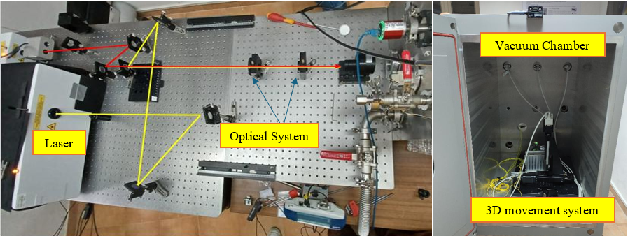
The experimental setup includes two different Nd:YAG pulsed laser, PL2250 and NL300, a vacuum chamber, a beam expander, a converging lens and a 3D automated movement system. Both lasers have a wavelength of 1064 nm. PL2250 has a pulse time of 80 ps and energy up to 0.1 mJ; Laser NL300 has a pulse time of 6 ns and energy up to 1.2 J.
DISC is mounted on the automated movement system and positioned inside the chamber, operating at the pressure of 10-6 bar.
The lasers are positioned on an optical bench and the pulses are directed through two different optical paths, into a beam expander which increases the pulse width by a factor of 2.5. The pulse, through a window on the vacuum chamber, is directed into a converging lens that focuses it onto the sensitive surface of DISC. The lens has a focal length of 75 mm. The MGSE is showed in the Fig1.

Sensing plate characterization
The signal detected by the PZTs depends not only on the impact pressure, but also on the impact location, and therefore the path of the shockwave to reach the PZTs and the interferences with the edges of the sensing plate.
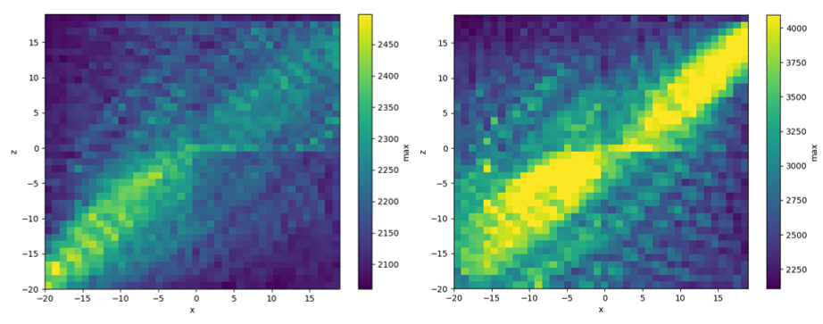
Therefore, a series of test was carried out to map the sensibility of DISC. A customized algorithm was developed to automate the test and control the coordinates of every laser shot. The tests were repeated at different levels of energy and varying the attenuation parameter. The parameters were tuned to obtain in every test signal in the range between the minimum sensibility and the saturation value. A step of 2 mm was set for the scanning. In this case, the laser power was kept at the minimum possible, to minimize the damaging of the sensing plate, between 5 and 15 mJ, according to the attenuation level.
The results obtained are shown in figure 2. The heatmaps represent two different PZTs, with different amplification gains; in this way it is possible to observe a wider range of impact momentum.

Power tests
Once the sensibility map was acquired, a number of points was selected, to perform further test and characterize the response of DISC at different levels of energy. In this case, the movement system was used to set the coordinates of the point to hit. It was observed a very good sensitivity, detecting energies close to 1 mJ, which is the minimum energy of the laser.
Data show, as reported in figure 3, in the area before the saturation, an almost linear correlation between the peak of the signal (reported in digital numbers) and the energy of the impulse.
Acknowledgement: This work has been funded by the ASI-INAF agreement N. 2023-14-HH.0
How to cite: Ruggiero, G., Della Corte, V., Cozzolino, F., Rotundi, A., Bertini, I., Inno, L., Tonietti, L., Longobardo, A., Grappasonni, C., Sindoni, G., and Ammannito, E.: DISC: Analysis of the performance and calibration strategy., Europlanet Science Congress 2026, The Hague, The Netherlands, 7–11 Sep 2026, EPSC2026-1010, https://doi.org/10.5194/epsc2026-1010, 2026.
The ability to determine the composition of extraterrestrial material directly in space is fundamental for future planetary and astrobiological research. Mass spectrometry provides a versatile approach for the analysis of micrometeorites, cosmic dust, and particles originating from atmospheres and surfaces of distant planetary bodies.
HANKA (~ Mass Analyzer for Cosmic Applications ) is a next-generation high-resolution mass spectrometer developed for in-situ space applications under strict resource constraints. It represents a versatile payload candidate for CubeSats up to large-scale missions. HANKA employs an Orbitrap™ electrostatic ion trap analyzer known for exceptional high mass resolution, accuracy and wide mass range (up to 2000 amu).
A laboratory prototype of HANKA has been constructed, and its capability to meet the requirements of high-resolution mass spectrometry has been proved experimentally. Measurements of solid particles produced detailed mass spectra with a resolving power exceeding 100 000 (m/ΔmFWHM) at the m/z 200, together with valid mass accuracy and isotopic ratio determination.
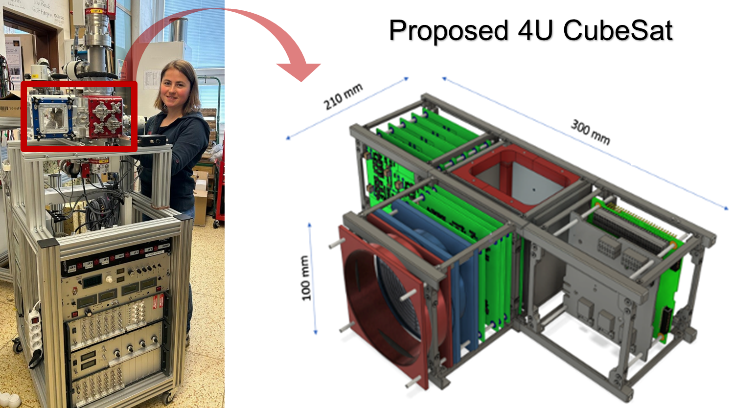
In addition to its analytical performance, the instrument was designed with emphasis to minimize the size, weight, and power requirements. A proposed 4U CubeSat configuration of HANKA incorporates a hypervelocity impact ionization source, the concepts previously demonstrated by the CDA space instrument. Current development efforts to reduce power consumption and size of the electronics.

HANKA laboratory prototype (left), and proposed 4U CubeSat configuration (right).
In summary, HANKA combines high-resolution mass spectrometry and compact design. The instrument has the potential to provide comprehensive chemical characterization of complex space dust and micrometeorite particles during future space missions. The analytical performance and capabilities of the instrument will be demonstrated through experimental results obtained by the laboratory prototype.
Acknowledgements: This work was supported by European Union ERA-Chair Project 101186661 ─ SPACE, and the Czech Science Foundation through grant No. 24-13757L.
References
- Briois C., Thissen R., Thirkell L., et al.; Planet Space Sci. 2016, 131, 33‐45.
- Makarov A.; Anal. Chem. 2000, 72, 1156–1162.
- Sanderink A., Klenner F., Zymak I., et.al.; Anal. Chem. 2023, 95, 3621−3628.
- Zymak Y., Zabka J., Polášek M., et al.; al.; Aerospace 2023, 10(6), 522.
- J. Goldsworthy et al., A&A 2003, 409, 1151–1167
How to cite: Malečková, M., Žabka, J., Zymak, I., Spesyvyi, A., Charvát, A., Lebreton, J.-P., and Abel, B.: HANKA: CubeSat Space Dust Analyser, Europlanet Science Congress 2026, The Hague, The Netherlands, 7–11 Sep 2026, EPSC2026-564, https://doi.org/10.5194/epsc2026-564, 2026.
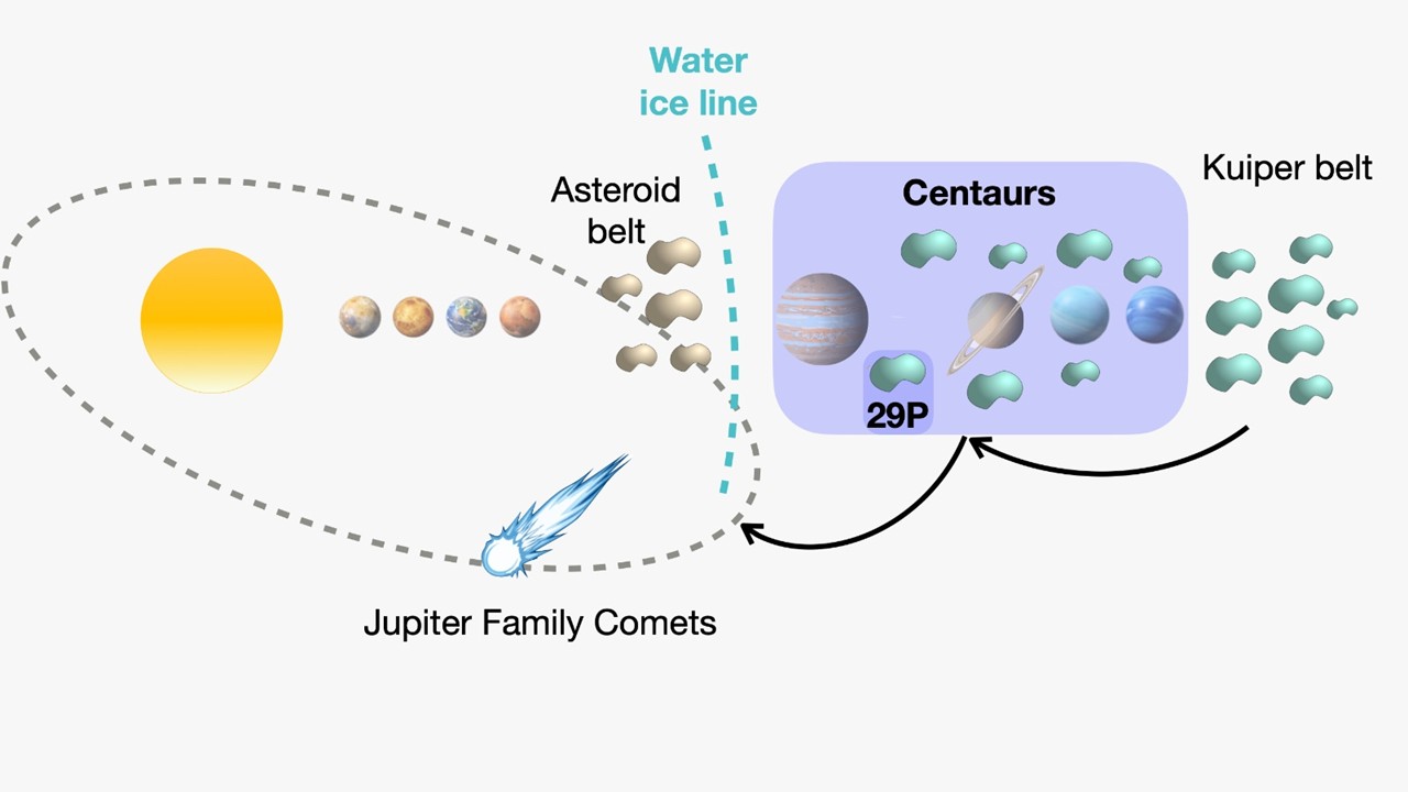
CIRCE (Centaurs’ Investigation, Reconnaissance and Compositional Exploration) is a mission concept for long-duration close-up exploration of the active Centaur 29P/Schwassmann-Wachmann, developed within the ESA Academy framework. The mission investigates the feasibility of sustained operations around an active icy small body beyond the water ice line through a combination of low-thrust trajectory design, close-proximity operations, and a multi-instrument payload for simultaneous surface, coma, dust, and plasma characterization. Centaurs represent a dynamically transitional population between Kuiper Belt Objects and Jupiter-family comets, preserving key records of icy planetesimal formation and early Solar System evolution (see Figure 1). Despite their scientific importance, no spacecraft mission has yet explored a Centaur in situ.
29P/Schwassmann-Wachmann is an exceptional target because it exhibits persistent and episodic activity at heliocentric distances near 6 AU, where water-ice sublimation alone cannot efficiently drive cometary activity. Observations suggest that supervolatile sublimation, crystallization of amorphous water ice, and localized venting processes may contribute to the observed outbursts, but the physical mechanisms governing this activity remain unresolved. Recent ground-based [1] and JWST [2] observations further indicate strong compositional heterogeneity and complex temporal variability in the coma and active regions.
CIRCE aims to constrain the origin and evolution of Centaurs by combining global surface characterization, compositional mapping, coma analysis, and temporal monitoring of activity. The mission science objectives include determining the volatile and isotopic composition of the coma, investigating the mechanisms driving activity beyond the water ice line, characterizing the internal structure and thermal state of the nucleus, and studying the interaction between the coma and the solar wind environment. The proposed payload includes visible imaging systems, infrared spectroscopy, and thermal mapping to characterize surface morphology and thermophysical properties; mass spectrometry to constrain volatile and isotopic composition; a dust impact analyser to investigate ejected material during activity; and plasma instrumentation to detect interactions between the coma and the solar wind.
The mission concept employs a low-thrust trajectory with a Mars gravity assist, enabling rendezvous with 29P and extended orbital operations around the nucleus. Long-term monitoring from close orbital distances would provide an unprecedented opportunity to observe recurrent outbursts, characterize active regions, and investigate the transition of icy bodies from the outer Solar System into the Jupiter-family comet population. CIRCE would therefore bridge key knowledge gaps between relatively pristine Kuiper Belt objects and evolved inner Solar System comets, while expanding the exploration of primitive small bodies into a population not yet visited by spacecraft.

Figure 1: Schematic overview of the heliocentric distances of the Centaur population, highlighting 29P/Schwassmann-Wachmann.
References:
[1] Paganini, Lucas, et al. "Ground-based infrared detections of CO in the Centaur-comet 29P/Schwassmann-Wachmann 1 at 6.26 AU from the Sun." The Astrophysical Journal 766.2 (2013): 100.
[2] Faggi, Sara, et al. "Heterogeneous outgassing regions identified on active centaur 29P/Schwassmann–Wachmann 1." Nature Astronomy 8.10 (2024): 1237-1245.
How to cite: Saveriano, F., Gurrutxaga, N., Beaumont, M., Goldmann, M., and Reis, M. and the CIRCE Mission Concept Team: CIRCE: A Mission Concept for In Situ Exploration of the Active Centaur 29P/Schwassmann-Wachmann, Europlanet Science Congress 2026, The Hague, The Netherlands, 7–11 Sep 2026, EPSC2026-696, https://doi.org/10.5194/epsc2026-696, 2026.
The Next Generation small-body Sample Return (NGSR) is a Japanese strategic large-class science mission candidate in the 2030s. Following Hayabusa, Hayabusa2, and upcoming Martian Moons eXploration (MMX), NGSR is planning to return samples from a Solar System primitive body. The samples returned by Hayabsua2 from the C-type asteroid Ryugu indicated the evolution process from its parent body and the transport of materials in the early Solar System [1]. However, the ultimate origin of the Solar System material and the formation of the first-generation planetesimals still remain unsolved. Thus, the science goals of NGSR include (1) unveiling the origin of the Solar System materials in galactic evolution and (2) unveiling the origin of the Solar System bodies to form planetesimals. To achieve these goals, we propose the NGSR Origins program targeting comets (NGSR-C), D-type asteroids (NGSR-D), and E-type asteroids (NGSR-E). The comet (e.g., 289P/Blanpain) is the target to investigate the origin of materials from pre-solar era and the formation process of planetesimals in the outermost Solar System. The D-type asteroid (e.g., 2001 SK162) is to constrain the evolution of organic matter and the formation process of planetesimals in the outer Solar System. The E-type asteroid (e.g., 4660 Nereus) is to investigate the evolution of materials in the innermost region of the Solar System and the formation process of inner Solar System. NGSR is strongly constrained by use of an H3 rocket and a Deep-Space Orbital Transfer Vehicle (DS-OTV) [2], a newly developing transportation system to be commonly used for many missions.
The NGSR spacecraft system consists of a DS-OTV as the main spacecraft and a lander for sample collection [2]. A concept study assumes its launch in early half of 2030s, arrival at the target for exploration, and return of samples to Earth within 6~8 years (NGSR-E or -D) to 13 years (NGSR-C). The mission instruments are categorized into four types: (1) remote sensing instruments for characterization of the target body and the landing site selection, including an optical navigation camera, a laser altimeter, and a thermal infrared imager. (2) sample return devices: A bullet and/or pneumatic type sampler on the lander, a kinetic impactor, and a mass spectrometer on the lander to measure volatiles on-site. Most of the collected samples will be transferred to the reentry capsule on the DS-OTV after sampling and rendezvous docking of the lander to the DS-OTV. (3) interior structure measurements: bistatic radar system, and small landing seismometer units deployed onto the surface. (4) other optional instruments to improve the scientific significance of this mission, including a near infrared spectrometer, a 10kg-sized small scientific deployable probe like the Hayabusa2 MASCOT, and a small dust and volatile detector as international collaboration. There remains an opportunity for the other instruments before the final decision of instruments. We will present the mission design, science operation, and instruments at that time.
[1] e.g., Nakamura T. et al. (2022) Science, 90, eabn8671.
[2] Saiki T. et al., (2025) Acta Astronaut., 235, 120-128.
How to cite: Okada, T., Kurokawa, H., Shimaki, Y., Sakatani, N., Fukai, R., Aoki, J., Kebukawa, Y., Kumamoto, A., Tanaka, S., Kawamura, T., Senshu, H., Suetsugu, R., Urakawa, S., Tatsumi, E., Wakita, S., Yumoto, K., Ishizaki, T., Saiki, T., and Tsuda, Y. and the NGSR Science Working Group: Next Generation Small-body Sample Return (NGSR) from primitive bodies as the next ISAS large-class science mission candidate, Europlanet Science Congress 2026, The Hague, The Netherlands, 7–11 Sep 2026, EPSC2026-725, https://doi.org/10.5194/epsc2026-725, 2026.
INTRODUCTION
The Emirates Mission to the Asteroid Belt (EMA) is an interplanetary mission to the Main Belt (1); during its journey the MBR Explorer Spacecraft will perform six fly-bys of primordial asteroids and planetary Gravity Assists targeting Venus, Earth and Mars before reaching asteroid 269 Justitia (2).
MIST-A is the Middle-Wave Infrared Imaging Spectrometer for Target Asteroids (3) aboard EMA. The instrument operates in the 2-5 𝜇m spectral range to study the asteroids’ surface composition and thermo-physical properties. MIST-A is composed of two units: the Optical Head (OH), which includes a telescope equipped with a scanning mirror and a spectrometer, and the Electronics Unit (EU). Mounted on the telescope’s entrance baffle is the Internal Calibration Unit (ICU), consisting of a diffuser and two IR emitters in front of which are placed polystyrene filters.
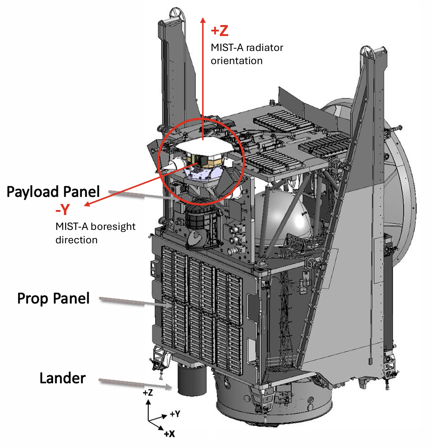
MIST-A is placed on the -Y side of the MBR with respect to the spacecraft’s Structural Reference Frame (SRF) as represented in Fig. 1. The instrument’s slit is aligned with the Z𝑆𝑅𝐹-axis and its boresight points along the -Y𝑆𝑅𝐹-axis, scanning in the X𝑆𝑅𝐹 direction. Its +Z-axis, towards which the instrument’s radiator is oriented, corresponds with +Z𝑆𝑅𝐹.

Fig. 1. MIST-A aboard the MBR Explorer.
MIST-A IN-FLIGHT CALIBRATION
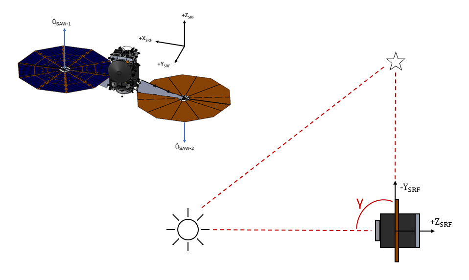
MIST-A’s on-ground calibration campaign will be performed at INAF-IAPS and will cover the characterization of the instrument’s performances and the ICU. The instrument will also undergo in-flight calibrations that are necessary to verify its correct operation and identify any unexpected change or degradation. MIST-A’s first in-flight calibration will happen during EMA’s Early Operations Phase shortly after launch and it will consist of the Internal Calibration carried out through the ICU to study the instrument’s relative spectral, spatial and radiometric performances. MIST-A will also perform in-flight geometric and radiometric calibrations. The main objective of the geometric characterization is to check the boresight's stability and its alignment within the SRF. The radiometric calibration aims to check MIST-A’s responsivity to verify the accuracy of the calibration pipeline that converts the raw data recorded in Digital Numbers (DN) into physical units of spectral radiance (𝑊/m2/𝜇𝑚 · 𝑠𝑟). Both procedures demand the observation of a bright IR source satisfying a specific set of requirements. The geometric calibration requires a target with an angular size 𝛿 ≤ 238 𝜇rad and a phase angle 𝛼 ≤ 90°, while the radiometric needs a large body with 𝛿 ≥ 4.65 mrad and preferably a phase angle 𝛼 ≤ 45°. Planning of both characterizations also has to consider that during the measurements the Sun needs to be kept out of the instrument’s FOV, which provides a requirement on the Sun-Probe-(-Y𝑆𝑅𝐹-axis) angle 𝛾, corresponding to the boresight orientation, of 𝛾 ≥ 90°. Finally, thermal analyses have shown that a Sun Keep-Out-Zone (KOZ) has to be implemented in order to protect the spacecraft’s subsystems from damage due to Sun exposure; this dictates the constraints for the angle 𝜃 between the Sun-Probe vector and the +Z𝑆𝑅𝐹-axis (Fig. 2).
Fig. 2. Sun KOZ defined by the allowed values (in green) of the Sun-Probe-(+Z𝑆𝑅𝐹)-axis 𝜃 angle (deg) as a function of the Solar Distance (AU) of the spacecraft throughout the mission.
Through the development of a Python program, a study was performed for each proposed target of the calibrations to identify the time windows throughout EMA’s journey where all requirements would be met and observations could be performed. Possible targets for the geometric calibration have been identified in Jupiter, Mars, Arcturus and Antares, while for the radiometric calibration the preferred source is the Moon, although Earth, Mars and Venus are valid alternatives.
Data on the location of the spacecraft, the Moon and the planetary targets in the J2000 Sun-centered frame used for the mission have been inferred directly from EMA’s Trajectory file, which has been developed through the SPICE System (5). The stars coordinates have instead been deduced from their distance from the Solar System, their Right Ascension and Declination.
During the analysis the spacecraft’s orientation was fixed with the X𝑆𝑅𝐹-axis normal to the Sun-Target-Probe plane (Fig. 3), so that the Solar Arrays are kept normal to the Sun, in the most optimal power-positive angle. This configuration is ideal but also the most restrictive, and in case no compatible targets are found it can be modified.

Fig. 3. Orientation of the spacecraft with respect to the Sun-Target-Probe plane during MIST-A’s in-flight calibration measurements.
RESULTS OF THE TARGET SELECTION
Through an ordered analysis that evaluated the compliance to each observation constraint for every proposed target, we found the indicative time windows inside which all requirements would be met thus allowing to perform the calibration with that specific body. These were then compared with the time marks defined for the fly-bys, the gravitational assists and the nine cruise phases performed during the mission.
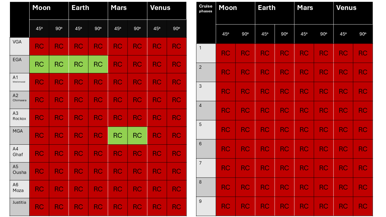
Tables in Fig. 4 show the results of the target selection study.

Fig. 4. Results of the target selection for the geometric (top) and radiometric (bottom) calibration, analyzing the available windows at fly-bys and gravity assists (left tables) and during cruise stages (right tables). The green cells point the windows where requirements are met and calibrations can be performed. For the radiometric two cases for the phase angle were considered: the preferable but more restrictive requirement of 𝛼 ≤ 45° and 𝛼 ≤ 90° as a second option.
The study confirmed that both stars can be used as targets for the geometric calibration, as well as Jupiter and Mars. The results of the analysis for the radiometric calibration indicate fewer opportunities, although they show that it should be possible to perform the characterization in two different stages and that the Moon is a viable target, as preferred. Additionally, this study was performed considering particularly constrictive requirements, which may be softened if multiple iterations of the calibrations are needed.
REFERENCES
1. Al-Mazmi et al., ,” AGU, , no. id. P44B-01, 2023.
2. Al-Mazmi et al., ,” COSPAR, , no. b1.1-0036, July 2024.
3. Raponi A., Filacchione G. et al., 2023, LPICo, 2851, 2450.
4. NASA NAIF, https://naif.jpl.nasa.gov/naif/spiceconcept.
How to cite: Cencia, C., Redick, R., Alblooshi, H., Pilinski, E., Reed, H., Villa, J., Lamprecht, B., Filacchione, G., and Ciarniello, M.: Target Selection for In-Flight Calibrations of the MIST-A Instrument, Europlanet Science Congress 2026, The Hague, The Netherlands, 7–11 Sep 2026, EPSC2026-986, https://doi.org/10.5194/epsc2026-986, 2026.
Please decide on your access
Please use the buttons below to download the supplementary material or to visit the external website where the presentation is linked. Regarding the external link, please note that Copernicus Meetings cannot accept any liability for the content and the website you will visit.
Forward to presentation link
You are going to open an external link to the presentation as indicated by the authors. Copernicus Meetings cannot accept any liability for the content and the website you will visit.
We are sorry, but presentations are only available for conference attendees. Please register for the conference first. Thank you.
PRIAMOS (PRImordial Asteroid Mission to understand the Origin of the Solar system), one of ten remaining ESA M8 mission candidates, is an asteroid sample return mission that will rendezvous with a D-type Near-Earth Asteroid (NEA), characterize its surface, and return a regolith sample to Earth. Unlike prior sample return missions, PRIAMOS will return rocky material not represented by meteorites and which comes from the un-explored archive of the far-outer solar system. The analyses of the returned sample in ground-based laboratories will pave the way to a holistic understanding of the origin of the solar system, the dynamical processes that shaped its evolution, and the origin of Earth as a habitable planet. Here we will provide the latest state of the mission.
Small solar system bodies are remnants of the solar system’s original protoplanetary disk that did not combine to form the more massive planets. These bodies include asteroids (main belt asteroids and Jupiter’s Trojans), trans-Neptunian objects (TNOs), and comets. These objects formed over a wide range of heliocentric distances and have subsequently been distributed across the solar system by dynamical interactions with the giant planets. As such, understanding the provenance and genetic relationships among the solar system’s small bodies is key for constraining the formation and primordial structure of the solar system, and the dynamical events that shaped its subsequent evolution. However, despite their importance, we lack key knowledge about how the distinct small bodies of the solar system are genetically related, how their formation locations varied in time and space, and how their chemical and physical properties have been modified over the history of the solar system. These knowledge gaps reflect. that only a very few of these bodies have been visited by spacecrafts and, in particular, the strong bias in the sampling of these bodies by meteorites and past sample return missions. For instance, while the Hayabusa1 and 2 and OSIRIS-Rex missions have demonstrated the enormous scientific potential of sample return missions, and the enhanced scientific value of carefully curated returned samples over meteorites, they were known to return materials represented by meteorites. These all derive from main belt asteroids and as such predominantly represent objects that formed in the vicinity of Jupiter. As such, the next frontier is to return material from the outer solar system, which until now has remained largely unsampled, but which holds the key to understand how the solar system formed and evolved. Here the case is presented that, owing to their primitive nature, D-type asteroids present objects that formed at much greater heliocentric distance that any meteorite parent body. While their closest meteorite analog are carbonaceous chondrites, D-type material does not seem to be present in our meteorite collections, probably because this friable primitive material does not survive atmospheric entry. Moreover, D-type asteroids are predicted to be scattered TNOs, and so they may have originally formed in the far outer disk and derive from the same population of primordial bodies as comets. Thus, analyzing a D-type sample will make it possible to identify the primordial array of materials present in the protoplanetary disk and to test models of solar system formation and evolution by determining the genetic relationships among the most primitive small bodies of the solar system. For these reasons, we propose PRIAMOS (PRImordial Asteroid Mission to understand the Origin of the Solar system), a sample return mission to a D-type near-Earth asteroid (NEA). PRIAMOS would be the first European-led sample return mission and, for the first time, would return a relatively large mass of outer solar system materials to Earth. The investigation of these materials in ground-based laboratories will be transformative for our understanding of early solar system evolution and will pave the way for building a new holistic model of the solar system.
How to cite: Marschall, R. and Kleine, T. and the PRIAMOS team: ESA M8 candidate PRIAMOS - A sample return mission to a D-Type Near-Earth Asteroid, Europlanet Science Congress 2026, The Hague, The Netherlands, 7–11 Sep 2026, EPSC2026-402, https://doi.org/10.5194/epsc2026-402, 2026.
The proposed PRIAMOS (PRImordial Asteroid Mission to understand the Origin of the Solar system) mission aims to revolutionize our understanding of the solar system’s formation by returning a pristine sample from a D-type asteroid. PRIAMOS would be the first European-led sample return mission. The scientific analyses of the returned sample will allow the determination of the nature of primordial materials of the solar system, test the modern view of the solar system evolution including an early giant planet instability, and constrain the importance of outer solar system materials as a potential source of water and other volatiles to Earth. The total sample mass needed to address the scientific objectives, for public display, and for long term curation and future analysis is 22 g. The detailed mission concept is presented at this meeting by Marschall et al. [1].
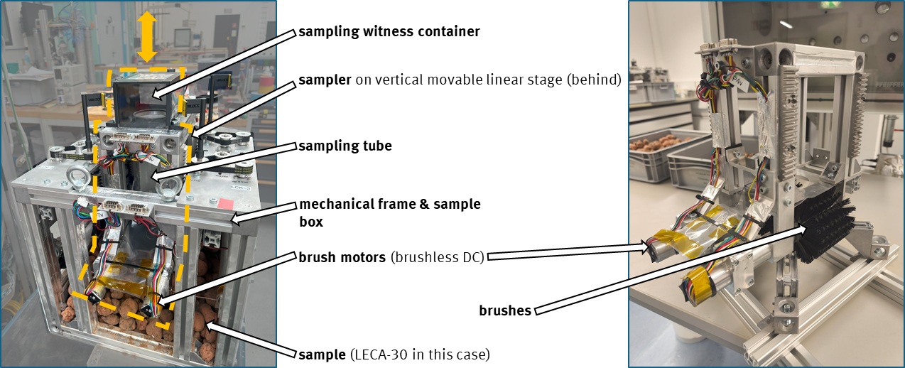
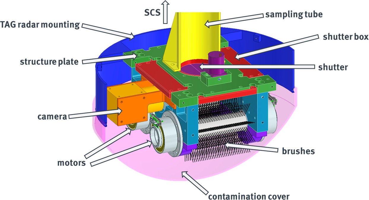
Here, we introduce the APOSSUM system – the Asteroid Payload for Obtaining, Storing, and Sample Return with Utility Module. APOSSUM is an instrument suite designed to collect, safely store, and return the sample to Earth. The APOSSUM comprises four key subsystems: the Brush Wheel System (BWS) for sample acquisition, the Sample Capture and Storage (SCS) system of containment and sealing of the sample, the Earth Reentry Capsule (REC) for safe return to Earth’s surface, and the Data Processing and Electronics (DPE) unit for integrated command, control, and data handling. The BWS employs counter-rotating brushes driven by motors to lift and transport particles from micrometers to centimeters during the touch-and-go (TAG) sampling into the sample catcher of the SCS. The BWS and results from the ongoing development and test campaign are presented at this meeting by Bannemann et al. [2]. The sample catcher is designed with a capacity to safely retain a minimum of 170 cm3 of material. Successful sampling will be monitored by a camera on the BWS as well as in-situ measurement of the electric permittivity in the sample catcher to quantify the sample amount during TAG. Here, we will present the preliminary design of the sample catcher and test measurements of the sample quantification by electric permittivity measurements of analog materials.
Sample contamination control in the APOSSUM is a critical design driver, following the requirement of the return of pristine material. All surfaces in contact with the sample will be manufactured from PEEK (polyether ether ketone). PEEK is chemically robust, resistant to abrasion, exhibits very low outgassing, and is widely used in ultra-clean laboratory environments. After sample collection the sample catcher will be transferred by the SCS system into the REC and hermetically sealed for the duration of the return flight and Earth atmosphere re-entry. The container is designed to retain any evolved volatiles from the sample. The temperature in the container will be monitored to document the sample environment. The REC is tasked with the safe return of the sample to the Earth’s surface. The envisioned design consists of a sphere-conical heatshield with a diameter of 700 mm built from a titanium-aluminium substructure to which the thermal protection shield is mounted. The REC is designed for a return to Earth at up to 12.8 km/s with a passive entry trajectory, and preliminary tests are currently ongoing. Finally, the APOSSUM system is also tasked with the command, control, and data handling of the asteroid remote-sensing instruments [1]. Key data products will be stored with the sample container and returned to Earth for redundancy.
In this presentation, we will describe the current state of the APOSSUM design and first test results of the sample storage process in the system. We will discuss the suitability for asteroid surface material sampling of D-types, and regolith materials more broadly. APOSSUM exemplifies a new era of sample return: a contamination-controlled, robust, and scientifically transformative payload that will deliver the most pristine extraterrestrial material ever returned to Earth.
[1] Marschall et al. (2026) EPSC2026
[2] Bannemann et al. (2026) EPSC2026-542
How to cite: Renggli, C. J., Kleine, T., Marschall, R., Gundlach, B., Plettemeier, D., Grott, M., Tubiana, C., and Gülhan, A. and the APOSSUM team: APOSSUM – Asteroid Payload for Obtaining, Storing, and Sample return with Utility Module for the PRIAMOS mission, Europlanet Science Congress 2026, The Hague, The Netherlands, 7–11 Sep 2026, EPSC2026-147, https://doi.org/10.5194/epsc2026-147, 2026.
Introduction: Asteroid exploration is a new frontier in Solar System exploration and a key research field for understanding its origin [1-7]. Building on the success of lunar and Mars exploration projects, China's Tianwen-2 (TW-2) asteroid mission is designed for a high scientific return. It will comprehensively investigate two distinct and scientifically valuable small bodies: the near-Earth asteroid 2016 HO₃ (Kamo'oalewa) [8-9] and the main-belt comet 311P [10]. This dual-target strategy is designed to address fundamental questions about the formation and evolution of our Solar System.
Scientific Questions and Objectives: The mission's scientific objectives are organized around five themes: characterizing the basic features of small bodies, understanding their origin and evolutionary history, exploring the origin of life and Earth's water, revealing solar influence, and investigating asteroids impact threats. For 2016 HO₃, a recently identified Earth quasi-satellite, the mission will determine its orbital parameters, rotation state, shape, size, and thermal radiation properties to study the origin and dynamical evolution of such rare co-orbital objects. Detailed mapping of its surface morphology, composition, and internal structure will provide essential context for the returned samples. Laboratory analysis of these samples will focus on physical properties, chemistry, mineralogy, and isotopic age, offering direct evidence to constrain Solar System formation models and the delivery of material to the inner planets. For main-belt comet 311P, the mission will perform similar measurements and study its unique orbit. Crucially, it will search for evidence of water and organic materials, and analyze its gas activity and near-space environment, which could provide key insights into the distribution of volatiles in the inner Solar System and the nature of transitional icy bodies.
Payload Configuration: To achieve these goals, the TW-2 mission carries ten scientific payloads. The remote sensing package is comprehensive: a visible and infrared imaging spectrometer (AVIRIS) for mineralogical mapping, a thermal emission spectrometer (ATES) for thermophysical property analysis, a multispectral camera (AMSCam), and a medium angle camera (AMAC) for high-resolution morphological and color imaging. Subsurface structure will be investigated by a core scan radar (ACSR). In-situ instruments include a Magnetometer (AMAG) to study remnant magnetic fields, a charged and neutral particle analyzer (CANPA) to characterize the solar wind interaction with the bodies, and a dust and volatiles analyzer (ADVA) to study dust and gas emissions from the main-belt comet. Additionally, a narrow angle camera (ANAC) and a laser detection and ranging (ALADAR) serve dual purposes for precision navigation and scientific observation. The technical specifications of these instruments, such as their spectral ranges, spatial resolutions, and detection sensitivities, are meticulously designed to fulfill the specific measurement requirements outlined for each scientific objective.
Characteristics of the Tianwen-2 Mission: TW-2 mission is distinguished by its pioneering target selection. It will perform the first dedicated exploration of an Earth quasi-satellite (2016 HO₃), investigating the origin and stability of this rare dynamical configuration. Simultaneously, it will conduct the first close reconnaissance of a main-belt comet (311P), a hybrid object that exhibits characteristics of both asteroids and comets, to study its volatile content and activity mechanisms. The mission employs a multi-phase strategy: remote sensing, in-situ analysis, and sample return from 2016 HO₃, followed by a flyby and remote sensing investigation of 311P. This integrated approach, combining sample return with detailed remote sensing of two unique small bodies, is expected to yield transformative results. The mission will advance our understanding of solar system dynamics, the nature and diversity of small bodies, the origin of Earth's water and prebiotic materials, and will demonstrate key technologies for future deep space exploration.
References: [1] Veverka, et al., 1999, Icarus, 107, 2-17. [2] Patzold et al., 2011, Science, 334, 491-492. [3] Zou et al., 2014, Icarus, 229, 348-354. [4] Zuber, et al., 2000, Science, 289, 2097-2101. [5] Akira, 2006, Science, 312, 1330-1334. [6] Yuichi et al., 1999, Acta Astronautica, 91, 356-362. [7] Lauretta et al., 2017, Space Science Reviews, 212, 925-984. [8] Warner et al., 2009, Icarus, 202, 134-146. [9] Reddy et al., 2023, Proceedings of American Astronomical Society, DPS Meeting. [10] Jewitt et al., 2018, The Astronomical Journal, 155, 231.
How to cite: Li, C., Liu, J., Ren, X., Yan, W., Zhang, Z., Li, H., and Ouyang, Z.: Scientific Objectives and Payloads Configuration of China’s Tianwen-2 Asteroid Exploration Mission, Europlanet Science Congress 2026, The Hague, The Netherlands, 7–11 Sep 2026, EPSC2026-219, https://doi.org/10.5194/epsc2026-219, 2026.
MoonIS (Moon Infrared Spectrometer) is a VIS–NIR spectrometer (0.4–2.3 μm) om board of the Emirates Lunar Mission (ELM) of the Mohammed Bin Rashid Space Centre (MBRSC) [1]. Rashid Rover 3 aims to investigate the geology and mineralogy of the southern polar terrain, explore Permanently Shadowed Regions (PSRs), and characterize the presence and distribution of water ice and hydroxyl on and beneath the lunar surface. The mission will investigate the lunar South Pole region, with launch currently planned not earlier of 2029. MoonIS spectrometer is a heritage of the Ma_MISS instrument on board the Rosalind Franklin rover of the ESA ExoMars mission [2].
Lunar PSRs are considered among the most promising reservoirs of water ice in the inner Solar System and constitute prime targets for sustainable lunar exploration. These permanently shadowed regions act as cold traps for volatiles delivered through cometary and asteroidal impacts, surface–solar wind interactions, and possibly endogenic outgassing processes [3–7]. Although hydrogen-bearing species have been detected, the fine-scale geomorphology, physical state, and spatial distribution of ice within PSRs remain poorly constrained because of the limited spatial resolution and signal-to-noise ratio of current datasets [8–11]. Moreover, the extent to which lunar water ice is exposed at the surface is still uncertain, as its morphology does not exhibit the expected diagnostic characteristics [12–14].
In situ investigations are therefore essential to constrain the abundance, distribution, and origin of lunar polar volatiles, as well as to clarify their implications for the history of water in the Solar System. For this reason, several space agencies are planning rover missions aimed at investigating water ice and the overall surface composition within PSRs, while also paving the way for future human exploration of the Moon.
MoonIS is derived from the Ma_MISS spectrometr on board of ESA’s ExoMars Rosalind Franklin rover, with significant adaptations to its optical head, calibration system, thermomechanical design, and electronics in order to operate under the harsh environmental conditions of the lunar surface. The instrument architecture consists of an optical head mounted on the rover mast and connected, through optical fibers, to a spectrometer unit located inside the rover body. Each fiber is coupled to a dedicated optical element and mapped onto the spectrometer slit, enabling the simultaneous acquisition of multiple spatial elements (“pseudo-pixels”) and the generation of hyperspectral images. The MoonIS optical head is composed of three optical elements specifically designed to maximize spatial coverage and spectral performance. By combining mast scanning and rover motion, the instrument will investigate the terrain surrounding the rover in both illuminated regions and Permanently Shadowed Regions (PSRs). To enable spectral observations within these extremely dark environments, MoonIS incorporates an onboard illumination system capable of acquiring measurements independently of solar illumination. In addition, the implementation of an external calibration target is being considered to ensure accurate radiometric and spectral calibration throughout the mission.
The primary scientific objectives of MoonIS are to:
- Detect and discriminate between H₂O- and OH-bearing materials;
- Quantify the abundance and spatial distribution of hydrated phases and water ice;
- Map the mineralogical composition of the landing site;
- Identify the major lunar lithological units;
- Detect and quantify key minerals, including pyroxenes, olivines, feldspars, and spinels;
- Characterize mineral assemblages and their spatial variability.
The instrument spectral range (0.4-2.3 micron), spectral resolution, signal-to-noise ratio, and spatial sampling have been specifically optimized to achieve these objectives under both illuminated and permanently shadowed conditions. By providing high-quality in situ hyperspectral measurements, MoonIS will deliver critical ground-truth data for the characterization of lunar polar volatiles, significantly improving our understanding of the origin, evolution, and preservation of water on the Moon, while also supporting future robotic and human exploration activities.
Acknowledgments:
This work is supported by ASI–INAF Agreement n. 2024-64-HH.0. The instrument is funded by ASI and manufactured by Leonardo S.p.A. (Italy).
References: [1] De Sanctis, et al. (2025) (EPSC-DPS2025-587). [2] De Sanctis et al. (2017): Astrobiology 17, 6, 7. [3] McCubbin et al. (2015) American Mineralogist 100: 1668-1707. [4] Honniball et al. (2021) Nature Astronomy 5: 121-127. [5] Pieters et al. (2009) Science, 326, 568–572. [6] Arnold, J. R. (1979) J.G.R. 84, 5659–5668. [7] Wang, J. et al. (2025) P.N.A.S. U.S.A. 122, e2501614122. [8] Hayne, P. O. et al. (2015) Icarus 255, 58–69. [9] Feldman, W. C. et al. Science 281, 1496–1500 (1998). [10] Lucey, P. G. et al. (2014) J.G.R. Planets 119, 1665–1679. [11] Massa et al. (2026) ELS 2026. [12] Ando, J., et al. (2025) P.S.J. 6, 62 (2025). [13] Williams, J.-P. et al. P.S.J. 5, 209 (2024). [14] Mahanti, P. et al. J.A.S.S. 40, 131–148 (2023).
How to cite: De Sanctis, M. C., Altieri, F., Biondi, D., De Angelis, S., Rossi, L., Ciarniello, M., Ferrari, M., Filacchione, G., Formisano, M., Frigeri, A., Galluzzi, V., Massa, G., Raponi, A., Piccioni, G., Ammannito, E., Pepe, R., and Regolini, J.: MoonIS Spectrometer on RASHID rover 3: investigating the lunar permanently shadowed regions, Europlanet Science Congress 2026, The Hague, The Netherlands, 7–11 Sep 2026, EPSC2026-528, https://doi.org/10.5194/epsc2026-528, 2026.
Introduction: Laser-induced breakdown spec-troscopy (LIBS) is versatile and is now widely used in the laboratory and in the field on Earth, as well as on the Martian surface for over a decade. This tech-nique has already led to a significant improvement in our knowledge of the geological history and context of the areas explored by the Curiosity and Persever-ance rovers, which are equipped with the ChemCam [1, 2] and SuperCam [3, 4] instruments, respectively. Efforts to develop LIBS for lunar exploration are also emerging, such as with the Chandrayaan 3 mis-sion by the Indian Space Research Organisation (ISRO), which successfully deployed and collected the first LIBS spectra on the Moon. IRAP and its partners are currently developing μLIBS: a 1.5 kg elemental mapper capable of scanning observations with 30 x 30 LIBS shots at a centimeter-scale work-ing space, with a 100 μm footprint per spot [5]. Sev-eral studies have shown that, under vacuum condi-tions, LIBS produces a weaker signal than that pro-duced under Martian conditions [6], but it is still highly useful for scientific investigation [7]. Rock mapping analysis using LIBS has also been success-fully carried out in laboratory experiments under vacuum and Martian conditions, allowing elemental quantification [8, 9]. However, the study of Chan-drayaan 3 LIBS data suggests that the laser focus could be a challenging factor in such an environ-ment, as many of their spectra contain significant noise and low signal intensity [10].
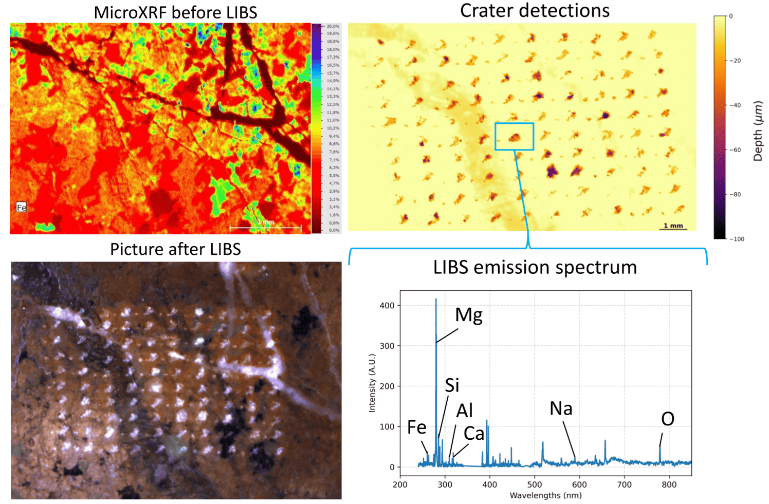
Methodology: Based on these observations, we are developing a calibration method, the robustness of which we will test with respect to focus variation and geometry. Specifically, we have selected four rock samples which compositional ranges and min-eral assemblages encompasses most common Moon samples. We obtained thin sections of these rocks and measured their composition using X-ray fluores-cence at a microscale (microXRF). The μLIBS pro-totype will perform 30x30 rasters providing ele-mental signals for each ablation spot. A Python rou-tine we have developed enables us to compare these LIBS measurements with microXRF analysis by superimposing a profilometric map of the craters onto the microXRF maps (Figure 1).

Figure 1: Steps of the calibration method. A python pipeline superposes the three images precisely to retrieve crater com-position enabling a direct comparison of the composition measured by both techniques.
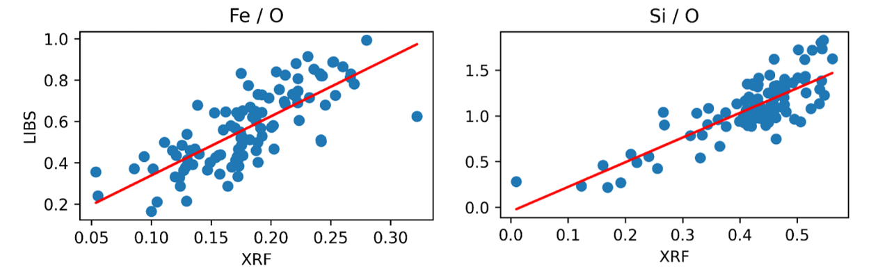
Results: The first laboratory experiments using the assembled μLIBS prototype are expected in July 2026. So far, to test this methodology, we used the ChemCam qualification model available at IRAP to create a 10x10 μLIBS map with two shots per spot on a thin section of altered lherzolite in a vacuum chamber at 10⁻⁴ mbar. In both LIBS and microXRF, we used the oxygen signal to normalize to overall signal for each ablation spot. We observed agree-ment between LIBS and microXRF with regard to the major elements (Fe, Mg, Si, Ca, Al and Ti), as well as some of the minor elements (Na and Ni) (Figure 2). Other minor elements observed with mi-croXRF in this sample, such as S, P, Ba and Zn, have a weak signature in the spectrum and could easily be confused with the background noise
As μLIBS laser spot diameter that is three times smaller than ChemCam, we could expect more irra-diance on the target providing a more intense signal that may help with the detection of minor elements. We will also improve our sample characterisation before performing LIBS by combining Elemental Dispersive Spectroscopy (EDS) and XMapTools, a powerful numerical tool for quantitative petrology [11]. Once a μLIBS calibration is established using these cross correlated abundance maps, we plan to vary the experimental conditions, as mentioned ear-lier, specifically the laser focus, to define precision criteria required to perform LIBS on the Moon. To ensure the effectiveness of this method on the select-ed samples, we will also perform LIBS shots using ChemCam with varying laser focus on a homogene-ous basaltic glass. Measuring the variation in com-position according to the distance between the true and optimal laser spot focus will help us understand the variation observed in the next μLIBS map exper-iments.

Figure 2: Comparison of LIBS signal under vacuum and cor-responding XRF quantification with O normalization for Fe and Si.
Conclusion: We are developing a new LIBS instru-ment that is seven times lighter than its predecessors, ChemCam and SuperCam, and capable of scanning samples to perform micro-scale elemental maps. This development builds on the legacy of these two instruments, which have been working on Mars for years. The Moon poses a new challenge for the LIBS technique, as its airless environment is less favoura-ble than the Martian atmosphere. However, we are developing a calibration method by correlating LIBS measurements on natural samples with the composi-tional maps obtained by non-destructive analysis (microXRF, EDS and XMapTools). The final goal is to test the robustness of the LIBS airless calibration with variations in other experimental parameters and define acceptable working conditions. Further results will be presented at the time of the conference.
References: [1] S. Maurice et al., Space Sci. Rev., 2012, [2] R.C. Wiens et al., Space Sci. Rev., 2012, [3] S. Maurice et al., Space Sci. Rev., 2021, [4] R.C. Wiens et al., Space Sci. Rev., 2021, [5] W. Rapin et al., EPSC-DPS, Helsinki, 2025. [6] F. Seel et al., Icarus, 2025, [7] J. Lasue et al. Journal of Geophysi-cal Research: Planets, 2012, [8] Manelski et al., LPSC, 2026, [9] Lee et al, LPSC, 2026, [10] F. Mourlin et al. Spectrochimica acta Part B, 2026 (un-der review). [11] Lanari et al., Computers and Geo-sciences, 2013
How to cite: Mourlin, F., Rapin, W., Maurice, S., Lasue, J., Forni, O., Cousin, A., Meslin, P.-Y., Dubois, B., Cheval, J.-F., Yana, C., Wiens, R. C., Manelski, H., Lee, D. J., Schröder, S., and Krybus, N.: EXPLORING THE CAPABILITIES OF μLIBS, A NEW LIGHTWEIGHT IN-SITU ELEMENTAL MAPPER FOR THE MOON., Europlanet Science Congress 2026, The Hague, The Netherlands, 7–11 Sep 2026, EPSC2026-925, https://doi.org/10.5194/epsc2026-925, 2026.
The Máni mission will contribute to the overarching goal of enabling Europeans to explore the Moon by providing high-value and novel information that will assist in mission planning, de-risk landings, and facilitate scientific exploration. This will be achieved through a mapping mission that is designed from its inception to take advantage of recent advances in the field of photoclinometry and photometry.
The Máni mission will be the first mission to employ a targeted multi-angular photoclinometric mapping approach to map key regions of interest of the Lunar surface. We aim to acquire the highest resolution orbital images of the Lunar surface, including the Polar regions, across a wide range of viewing geometries. From these images, we will produce detailed maps of the topography and reflectance properties at a resolution like that of the images. Additionally, through photometric analyses, we will provide sub-pixel information on surface properties down to mm-scale. Uniquely, from the probabilistic nature of the novel data processing employed, mission data products will all be accompanied with a measure of their level of confidence. This implies that future missions can select, e.g., landing sites that are not only predicted to comply with their mission requirements but also have a high level of confidence of complying with their requirements, thus lowering risks and increasing chances for mission success.
The mission data processing is improved relative to already published work by mission members (1) in its integration of high-resolution imagery with available a priori information like laser altimetry data. It features a computationally efficient and advanced photoclinometric model that accounts for complex illumination and observing geometry. This enables pixel-level resolution in the simultaneous output of both topographic maps and surface reflectance maps. While novel and under ongoing development, the mission data processing approach is validated using available Lunar images.
Exploration and scientific goals
Below, we present a selection of studies that highlight the range of investigations that can be undertaken based on Máni mission data products.
Assessing landing and mission sites of importance for human and robotic exploration
The primary focus of the Máni mission is to provide higher-resolution mapping of potential landing sites and locations of interest for exploration. The high-resolution images (as good as 20 cm/px at 50 km altitude) and topographic maps provided by the Máni mission enable unprecedented identification of hazards such as boulders, craters, and slopes that could jeopardize landing success. In particular, the ability to provide not only an accurate high-resolution topography of candidate landing sites but also assess the level of confidence of this presents a novel ability to not only select sites that are predicted to meet mission/lander requirements but sites that do so with a high probability.
Sites of importance to future human and robotic exploration imposes demanding requirements on the operational orbit of the mission as many of these, e.g. for the Artemis missions, are situated close to the Lunar South Pole (2–4).
Quantifying Earths albedo – a key parameter in climate models
Detailed mapping of the lunar reflectance properties for two key regions, Grimaldi and Crisium, that has historically been used for Earthshine observations (5, 6) will enhance the value of lunar Earthshine data. It will not only strengthen future earthshine measurements but also enable a transformative reanalysis of archived earthshine data. This will yield more precise global (semi‐hemispheric) albedo estimates and facilitate targeted assessments of polar albedo—a critical parameter given current concerns over ice-cap melt, as well as address the observed decline in terrestrial albedo over a 20-year period.
Effects of space weathering on the micro-texture of Lunar regolith
With the Máni mission we can take a new step forward in efforts to characterize and understand the lunar micro-texture. By deliberately targeting geological units from different ages and levels of maturity, we will be able to decipher the processes creating the regolith and estimate the evolution timescale. The Máni mission will augment these studies by mapping photometric properties at a resolution as good as ~20 cm/px. The high resolution provided by the Máni mission will also enable investigation of how other geological processes – e.g., lunar swirls, crater rays and volcanic flow – affect and modify the surface micro-texture.
Mission and spacecraft
The Máni mapping methodology requires the acquisition of at least 5, preferentially 10, overlapping high-resolution images of a region of interest covering a range of viewing angles separated by more than 100°. Furthermore, at least two illumination angles, separated by at least 20°, must be captured as part of the images acquired of a region of interest. These requirements imply that at least two overflights, acquiring 5 images during each, of the target area separated in time by at least a full Lunar sideral period are needed to acquire the necessary image-data to map a region of interest.
The Máni spacecraft is developed around the single large primary payload of the mission - an optical 300 mm telescope with a panchromatic 2D detector capable of acquiring images of the Lunar surface at a resolution as good or better than 20 cm/pixel at 50 km altitude. A secondary smaller colour imager intended to provide context for the primary images is also included.
References
- I. Fernandes, K. Mosegaard, Planet. Space Sci. 218, 105514 (2022).
- E. Peña-Asensio, Á.-S. Neira-Acosta, J. M. Sánchez-Lozano, Acta Astronaut. 226, 469–478 (2025).
- C. Orgel et al., Planet. Sci. J. 5, 29 (2024).
- S. J. Boazman et al., Icarus. 421, 116240 (2024).
- P. R. Goode et al., Geophys. Res. Lett. 48 (2021), doi:10.1029/2021gl094888.
- P. Thejll, H. Gleisner, C. Flynn, Astron. Astrophys. 573, A131 (2015).
How to cite: Frydenvang, J., Losiak, A., Fernandes, I., Karoff, C., Mosegaard, K., Schmidt, F., Thejll, P., Bonnet, P., Kjeldsen, H., Mayorga, I. L., Frandsen, M. T., Nielsen, J. F. D., Gleisner, H., Lancery, H., Andrieu, F., Schiøler, H., Hinse, T. C., and Scott, J.: Máni - a Lunar photoclinometric mapping mission, Europlanet Science Congress 2026, The Hague, The Netherlands, 7–11 Sep 2026, EPSC2026-1033, https://doi.org/10.5194/epsc2026-1033, 2026.
Introduction
The Canadian Lunar Rover hosted a suite of instruments that included the MultiSpectral Imager (MSI), a panchromatic camera developed by CanadenSys Aerospace to characterize regolith and rocks within 1 m of the rover. MSI is meant to acquire multispectral imagery by actively illuminating the surface with six pairs of LEDs spanning the 365–940 nm range, enabling analysis of the microscale texture, structure and mineralogical composition at the lunar surface.
Photogrammetric techniques have been applied to evaluate surface morphology from in situ images collected on the Moon (e.g., [1–3]). With a nominal ground sample distance of 50 µm at its optimal focal distance, MSI images could be used to reconstruct microscale 3D models along a rover’s traverse. The standard approach for 3D modelling using monocular images is structure-from-motion, which also requires large volumes of images acquired from multiple perspectives of a target area. In the context of planetary robotic operations, this would involve significant dedicated rover motion, time, and data bandwidth. Alternatively, a 3D model could be reconstructed from MSI images collected from only two imaging stations using stereophotogrammetry. By registering complementary imagery from other onboard cameras across the same stations, the known camera baseline among LRM instruments can be leveraged to solve for MSI camera poses.
Here we evaluate MSI’s capability to produce microscale point clouds under realistic rover operational conditions by leveraging the known geometric relationship between each imager.
Despite the official cancellation of the mission in March 2026, the capabilities developed to date remain applicable to scientific objectives using similar instrumentation on other robotic missions.
Imaging campaign
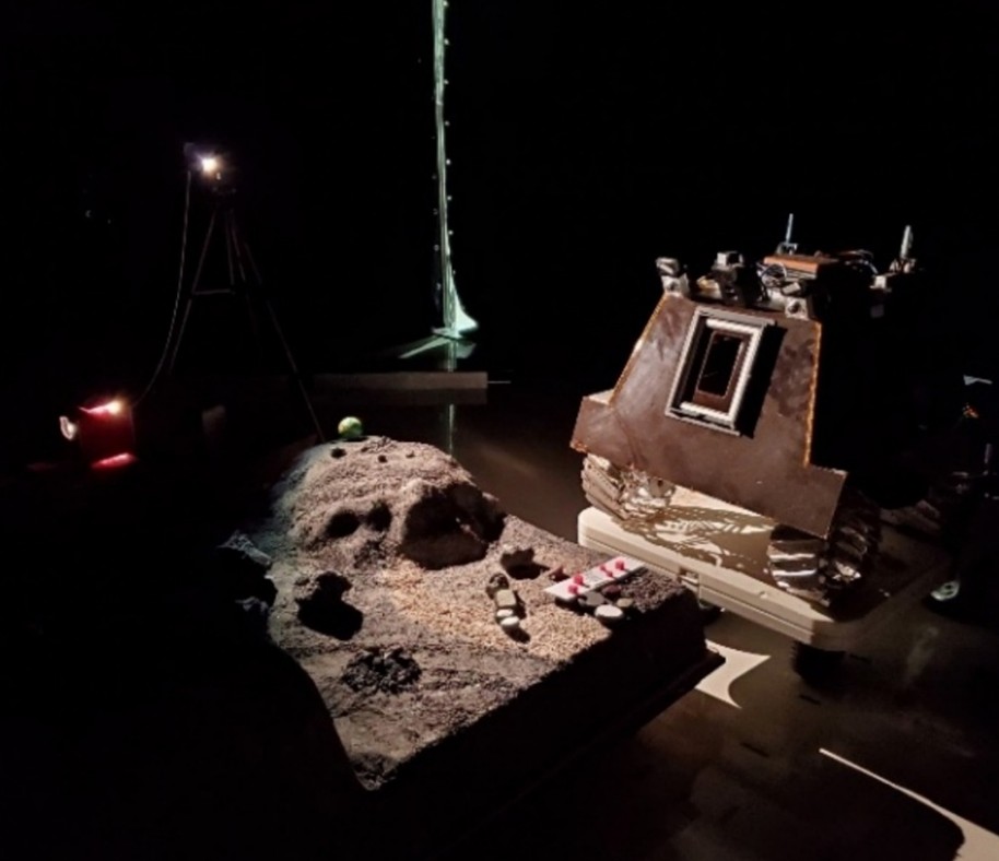
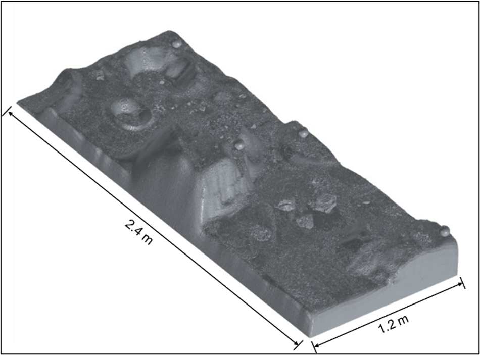
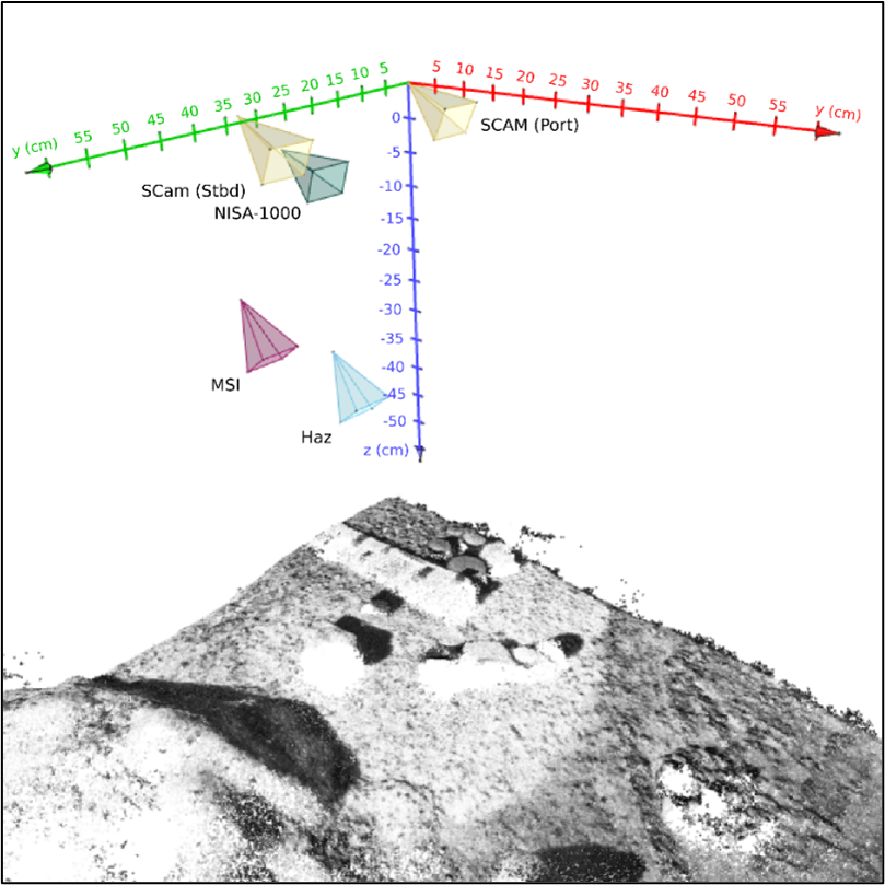
A science imaging campaign was conducted with the engineering model (fig. 1) of the rover in October 2025 at the Canadian Space Agency. We integrated 56 images taken by rover cameras of the Lunar Unstructured Scanning Rig (LUSR, shown in fig. 1 and fig. 2), a lunar model designed by CSA to characterize the accuracy of 3D sensors. Cameras included MSI; StereoCam (SCAM), a pair of RGB cameras mounted near the top of the rover with overlapping fields of view; HazCam, a forward- and downward-looking RGB hazard camera with a wide field of view; and NISA-1000, a forward-looking camera mounted near the top of the rover and equipped with a long-pass near infrared filter.
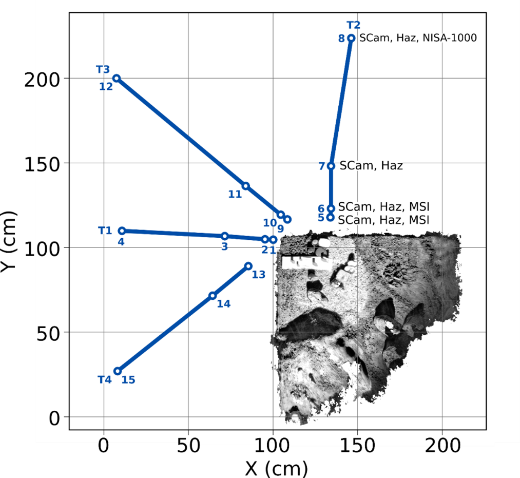
Camera poses were directed toward a region of 50 × 50 cm situated at one corner of the LUSR. The rover was positioned at 15 locations along four radial transects around the selected corner, imaging the target with each camera for which the LUSR was within the field of view (fig. 3).

Figure 1. The lunar rover engineering model next to the LUSR target area.

Figure 2. 3D mesh of the LUSR.

Figure 3. Transects T1-T4 and imaging stations 1 to 15, shown relative to the 3D point cloud of the target area. The imagers used at typical distances from the LUSR are indicated for T2.
Methods
All photogrammetric processing was conducted with the Ames Stereo Pipeline [4]. We first refined the geometric relationship between all cameras through a series of bundle adjustment passes constrained by a digital elevation model (DEM) and by uniformly distributed dense matches. A reference DEM made from StereoCam images was used to orthorectify all images and better constrain the feature matching and stereo correlation steps. Hazcam, MSI and NISA-1000 images were progressively included to the reconstructed scene using multiple “bundle_adjust” iterations. The 3D model was scaled using a set of control points from a handmade calibration target displayed at the center of the scene. We then used the “parallel_stereo” tool to generate a 3D point cloud from two MSI images taken at imaging stations 1 and 2, separated by 5 cm along a single radial transect (T1). For this, camera poses and dense matched features were derived from the previously calibrated camera rig.
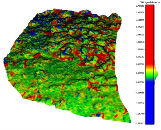
We compared our photogrammetry-derived point clouds with a reference mesh of the LUSR made with the MetraScan (Creaform) metrological 3D scanner (see fig. 2). Distance statistics were derived from cloud to mesh (C2M) distances to evaluate each model’s accuracy.
Results
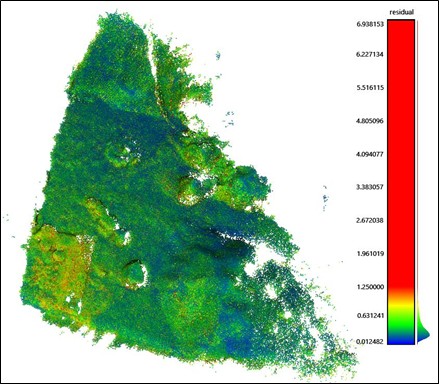
The calibrated camera 3D positions and orientations are shown in figure 4. Residuals of the triangulated features from the rig calibration 3D model are shown in figure 5, with a median reprojection error of 0.31 px, and RMS reprojection error of 0.47 px.
The point cloud resulting from the stereo process contains 9M features and median nominal point spacing of 44.3 μm. A 3D visualization of C2M distances between triangulated features and the LUSR mesh is shown in figure 6. We achieve a median absolute deviation of 173 μm (RMS of 387 μm) . For comparison, the median particle size of Apollo sample returned lunar soils is of 70 μm.

Figure 4. Calibrated camera positions and rotations relative to the triangulated point cloud resulting from the rig calibration process.

Figure 5. Residuals (pixels) for triangulated points from the rig calibration model.

Figure 6. C2M distance (mm) between the stereo point cloud and the reference LUSR mesh.
Conclusion
The MSI can be used to generate point clouds with micrometric spatial resolution by collecting two images with overlap of a target separated by a 5 cm rover repositioning. Our approach relies on the complementarity of multiple instruments onboard the rover to scale the model and constrain the camera poses. In future work, we will evaluate the ability to constrain the MSI poses from a reduced image dataset collected at 1 or 2 imaging stations. We will also test benchmark convolutional neural network feature matching algorithms that may be more robust to the heterogeneous optical properties of our camera rig.
References
[1] Helfenstein and Shepard (1999), Icar 141, 107.
[2] Le Mouélic et al. (2020), Remote Sens. 12(11), 1900.
[3] Guo et al. (2021), Geophys. Res. Lett. 48, e2021GL094931.
[4] Beyer et al. (2018), Earth Space Sci. 5(9), 537-548.
How to cite: Diotte, F., Lemelin, M., A. Cloutis, E., Teti, F., Morisset, C.-E., Gingras, D., and Osinski, G.: Microscale 3D reconstruction of the lunar surface from constrained in situ robotic imaging, Europlanet Science Congress 2026, The Hague, The Netherlands, 7–11 Sep 2026, EPSC2026-713, https://doi.org/10.5194/epsc2026-713, 2026.
Please decide on your access
Please use the buttons below to download the supplementary material or to visit the external website where the presentation is linked. Regarding the external link, please note that Copernicus Meetings cannot accept any liability for the content and the website you will visit.
Forward to presentation link
You are going to open an external link to the presentation as indicated by the authors. Copernicus Meetings cannot accept any liability for the content and the website you will visit.
We are sorry, but presentations are only available for conference attendees. Please register for the conference first. Thank you.
The Mars Magnetosphere, ATmosphere, Ionosphere and Space‑weather SciencE (M‑MATISSE) mission is an ESA Medium‑class (M7) candidate. M‑MATISSE is designed to address one of the most outstanding challenges in Mars science: understanding how the solar wind and space‑weather drivers couple simultaneously to the Martian magnetosphere, ionosphere, thermosphere, and lower atmosphere, and how energy is transferred across these interconnected regions.
The primary scientific objective of M‑MATISSE is to characterize the spatio‑temporal variability of the Martian Magnetosphere–Ionosphere–Thermosphere (M‑I‑T) system, its response to solar‑wind forcing, and the processes governing the dissipation of external energy at Mars. These couplings play a fundamental role in controlling atmospheric escape, auroral activity, radiation penetration, and the long‑term evolution of the Martian atmosphere and climate. In addition, quantifying the space weather and space‑climate environment at Mars is critical for future robotic and human exploration, as it enables improved forecasting of hazardous radiation and plasma conditions.
M‑MATISSE addresses these objectives through three core science themes:
(1) global characterization of M‑I‑T coupling via coordinated measurements of solar‑wind energy input and magnetosphere–ionosphere response;
(2) determination of the radiation environment and the absorption, redistribution, and variability of energy within the M‑I‑T system; and
(3) investigation of ionosphere–lower‑atmosphere coupling, an interface that remains poorly explored but is crucial for understanding solar energetic particle impacts and radio‑wave propagation at Mars.
The mission concept consists of two coordinated orbiters carrying complementary, high‑heritage payloads. Together, they provide a multi‑point observational framework that combines in‑situ plasma measurements with remote sensing of the ionosphere and lower atmosphere, including radio cross‑link observations between spacecraft. This configuration enables simultaneous sampling of the upstream solar wind, the Martian plasma environment, and regions extending deep into the nightside magnetotail, an observational capability not previously achieved at Mars.
Beyond planetary science, M‑MATISSE will provide the heliophysics community with a dedicated solar‑wind monitor at ~1.38-1.66 AU, offering valuable constraints on solar‑wind and solar‑transient propagation in the inner solar system. By linking solar disturbances from interplanetary space down to the Martian surface, M‑MATISSE represents the first mission fully dedicated to planetary space weather at Mars, with transformative implications for both fundamental science and future exploration.
How to cite: Sanchez-Cano, B., Leblanc, F., and Witasse, O. and the M-MATISSE: The M‑MATISSE mission: Exploring planetary space weather at Mars, Europlanet Science Congress 2026, The Hague, The Netherlands, 7–11 Sep 2026, EPSC2026-396, https://doi.org/10.5194/epsc2026-396, 2026.
Understanding the Martian atmosphere requires direct, vertically resolved measurements of winds. Despite decades of orbital and in situ exploration, wind profiles remain poorly constrained, limiting our ability to validate general circulation models (GCMs), quantify dust-lifting mechanisms, and predict atmospheric variability relevant to entry, descent, and landing (EDL). Existing wind information relies primarily on surface sensors with limited spatial representativeness or on tracer tracking techniques using water vapor and clouds, both of which suffer from incomplete coverage and intrinsic ambiguities. To address this long-standing observational gap, we are developing two complementary Doppler wind lidars dedicated to profiling winds and aerosols in the Martian atmosphere: MADWIL (Mars Doppler Wind Lidar), designed for orbital observations, and MARBLL (Mars Boundary Layer Lidar), a compact surface-based system dedicated to the planetary boundary layer.
Both instruments rely on the same Doppler lidar concept. While MADWIL operates at 532 and 1064 nm, MARBLL only uses the 532 nm wavelength. Both are optimized for backscatter from ubiquitous Martian dust aerosols. Winds are retrieved from the Doppler shift measured at 532 nm using a quadrichannel Mach–Zehnder interferometer (QMZ) spectral analyzer, enabling line-of-sight (LOS) wind retrievals with expected precision on the order of 1 m s⁻¹ and a LOS ambiguity range of approximately ±270 m s⁻¹. Simultaneous aerosol backscatter profiling at 1064 nm provides information on dust and cloud vertical distributions, with polarization-sensitive detection enabling discrimination between aerosol types.
MADWIL has been preselected on ESA LightShip1 and is designed to provide global measurements of horizontal winds and aerosol backscatter from orbit. The instrument concept includes a multiwatt Nd:YAG laser transmitter, a co-aligned SiC telescope optimized to minimize solar background contamination, and a thermally controlled optical bench. MADWIL is expected to retrieve wind profiles from the surface up to ~60 km altitude, depending on atmospheric dust loading, with kilometer-scale vertical resolution. These measurements will constrain atmospheric circulation patterns, wave activity, and dust transport processes from local to planetary scales while providing key inputs for GCM validation and EDL studies.
MARBLL applies this observational capability to the near-surface atmosphere by targeting the Martian boundary layer, where exchanges between the surface and atmosphere control dust lifting, turbulence, and diurnal circulation. The instrument is conceived as a compact and resource-efficient lidar suitable for landed platforms. By continuously profiling winds and aerosols in the first kilometers above the surface, MARBLL will provide unprecedented insight into boundary-layer dynamics and their coupling to the larger-scale circulation observed by MADWIL from orbit.
A laboratory breadboard has been developed to validate the QMZ Doppler measurement principle and establish the performance prediction framework shared by both instruments. In parallel, an Observing System Simulation Experiment (OSSE) framework is under development using Mars climate model outputs and realistic aerosol scenarios to assess retrieval performance and support instrument trade-offs in laser energy, telescope aperture, and detector configuration.
Together, MADWIL and MARBLL form a complementary observational strategy spanning the Martian atmosphere from the surface to the middle atmosphere. By combining global orbital mapping with continuous local boundary-layer profiling, these instruments would provide the first comprehensive vertically resolved wind dataset at Mars, establishing a transformational benchmark for understanding Martian atmospheric dynamics, aerosol transport, and climate variability.
How to cite: Montmessin, F., Patel, M., Arruego, I., Gautier, T., Forget, F., Newman, C., Chide, B., Bernardi, P., Bertrand, T., Toledo, D., Stcherbinine, A., Tirsch, D., Lange, L., Holmes, J., Apestigue, V., Leseigneur, Y., Määttänen, A., Fouchet, T., Buey, T., and Rees, J.-M.: Sensing winds on Mars: a new pathway toward local and global measurements, Europlanet Science Congress 2026, The Hague, The Netherlands, 7–11 Sep 2026, EPSC2026-339, https://doi.org/10.5194/epsc2026-339, 2026.
The Mars Atmosphere Dynamics aNd chEmistry Submillimeter Spectrometer (MADNESS) was selected by ESA for the LightShip-1 mission to address the key science goals of i) Atmospheric circulation and dynamics, ii) Water cycle, clouds and chemistry, and iii) Enabling Mars exploration. Inherited from the flight-proven Submillimetre Wave Instrument (SWI) instrument currently operating aboard the Juice mission to Jupiter, MADNESS will provide repeatable, high-precision measurements of the Martian atmospheric dynamics, thermal structure, and chemical composition from 20 to 120 km altitude, along with monitoring of surface thermal emission.
MADNESS features two spectral channels, covering the 527-635 GHz and 1066-1286 GHz ranges, each equipped with dual spectrometers:
- A broadband autocorrelator spectrometer (ACS) for sounding of multiple species simultaneously,
- A Chirp Transform Spectrometers (CTS) for ultra-high-resolution line profiling.
Using dedicated pointing mechanisms that enable both nadir and limb observations, and targeting key gaseous species (CO, H2O, H2O2, HO2, O2, HCl, HF, NO, and their isotopologues), MADNESS will enable unprecedented insights into Mars' circulation, water cycle, and active hydrogen, oxygen, chlorine, and nitrogen chemistry.
Leveraging the Doppler shift of spectral lines, MADNESS will directly and comprehensively survey, for the first time, horizontal wind velocities from 20 to 120 km altitude, with a precision and vertical resolution better than 10 m/s & 10 km. It will simultaneously probe the temperature structure over the same vertical range, with 1 K accuracy. Unaffected by dust opacity and non-local thermodynamical equilibrium (non-LTE) effects, MADNESS will provide the most detailed and seasonally complete climatology of Mars to date. These first-ever co-located measurements of temperature and wind represent an unprecedented dataset for Mars, enabling direct constraints on atmospheric dynamics and facilitating data assimilation into global circulation models to improve predictive understanding of the Martian climate.
MADNESS will also conduct a comprehensive investigation of the Martian water cycle and its associated oxidizing chemistry, through precise vertical profiling of key species. Combined with transport effects derived from wind measurements, these observations will offer critical insights into atmospheric stability and photochemical balance, shedding light on the long-term evolution of Mars' atmosphere.
MADNESS draws on advanced heterodyne receiver designs and compact, low-resource subsystems tailored to Lightship’s mass, power, and data constraints. With strong heritage in submillimeter planetary spectroscopy, our team combines scientific excellence with proven technical capabilities. Spread over seven European countries and Japan, the MADNESS scientific team gathers experts in spacecraft operation planning, submillimeter data analysis, Mars atmospheric dynamics and chemistry, Mars data assimilation, and surface physics, providing a uniquely integrated view of Mars' atmospheric circulation, water cycle, and photochemistry, taking a step beyond our current understanding of the Red Planet and paving the way for future exploration.
How to cite: Fouchet, T., Schulz-Ravanbakhsh, A., Skup, K. R., Murk, A., Wirström, E., Yamada, T., Hübers, H.-W., and Cavalié, T. and the MADNESS Consortium: The Mars Atmosphere Dynamics aNd chEmistry Submillimeter Spectrometer, MADNESS, selected for the ESA LightShip-1 mission to Mars, Europlanet Science Congress 2026, The Hague, The Netherlands, 7–11 Sep 2026, EPSC2026-781, https://doi.org/10.5194/epsc2026-781, 2026.
Understanding the present-day behavior of water on Mars, including atmosphere–subsurface exchange processes, the possible formation of transient brines, and the stability of shallow subsurface ice, remains one of the major open questions in planetary science. HARPOON (Hydration And Regolith Penetration Observatory On Mars) is a mission concept aimed at investigating how water actively exchanges between the Martian atmosphere and subsurface, and to what extent these processes may lead to the formation of transient liquid phases under present-day Martian conditions. The mission is based on the deployment of a reduced network of penetrator-type probes [1] at different latitudes on Mars, enabling simultaneous atmospheric and subsurface measurements over diurnal and seasonal timescales. Previous presentations of the HARPOON mission focused primarily on the overall mission concept, penetrator architecture, and technical implementation [2]. The present work instead focuses on the scientific objectives of the mission, the proposed atmospheric and subsurface sensor suite, and the mission configurations required to achieve these objectives, including the evaluation of trade-offs associated with the number of probes, latitudinal deployment, measurement sampling strategies, and operational periods needed to characterize water exchange processes and potential transient brine formation on Mars.
REFERENCES:
[1] Ignacio Arruego et al., “Mars environmental networks through the MarsConnect microprobes”, EPSC Abstracts, Vol. 17, EPSC2014-92.
[2] Arruego, I., Apéstigue, V., and Toledo, D. and the MarsConnect and HARPOON teams: HARPOON mission concept: Hydration And Regolith Penetration Observatory On Mars, EPSC-DPS Joint Meeting 2025, Helsinki, Finland, 7–12 Sep 2025, EPSC-DPS2025-1604, https://doi.org/10.5194/epsc-dps2025-1604, 2025.
How to cite: Toledo, D., Arruego, I., and Apéstigue, V. and the MarsConnect and HARPOON teams: HARPOON mission — Hydration And Regolith Penetration Observatory On Mars —: scientific objectives and sensor suite, Europlanet Science Congress 2026, The Hague, The Netherlands, 7–11 Sep 2026, EPSC2026-505, https://doi.org/10.5194/epsc2026-505, 2026.
Surface imaging is a key source of planetary science data throughout the solar system. As technology advances and science priorities evolve, novel exploration methods—such as aerial drones (e.g. Ingenuity, Dragonfly) or descent probes (e.g. DAVINCI)—increasingly characterise upcoming planetary science missions, providing new opportunities and challenges for conducting surface imaging.
We present an imaging concept for a wide-angle descent imager to capture downward-looking images with a full hemispherical field of view during a descent to a surface. Hemispherical descent imaging provides a multi-resolution view of a surface with high resolution in a localised area, and lower-resolution contextual information in a large surrounding area, with smooth, continuous transition in resolution, unlike nested orbital images. This wide-angle coverage enables geological analysis that bridges orbital and landed imagery; provides photometry over a wide range of viewing angles; and enables unique 3D terrain reconstruction.
Using field emulation and image simulations, we characterise the data return of a hemispherical descent imager. Close to optimal resolution and coverage can be achieved with relatively few (~5-10) images, suiting the technique to short-lived, high-speed descents. This technique is a compelling option for performing planetary surface imaging from small, low-cost descent probes. We discuss potential use cases and how returned data can enable novel planetary science.
How to cite: Persaud, D. M. and Brydon, G. F.: A concept for hemispherical descent imaging for planetary science, Europlanet Science Congress 2026, The Hague, The Netherlands, 7–11 Sep 2026, EPSC2026-160, https://doi.org/10.5194/epsc2026-160, 2026.
- Introduction
Lava tubes and impact melt pits, in planetary settings have gained increasing attention during the last years. They have many characteristics that made them suitable locations for the future development of settlements on the Moon or Mars [1]. These systems can be associated with large underground spaces, which present several advantages in comparison to locations exposed to the surface, like protection from radiation and extreme environmental conditions, stable temperatures, solid terrain, and even the possibility of hosting water and other volatiles [2,3].
Unfortunately, accessibility to the caves is difficult, as the only entrances are usually collapsed portions of the roof, which end up creating vertical holes that are difficult to traverse and explore [4]. Within this context, the DaedalusCAM is a protype system thought to explore the collapses leading to lava tube or underground caves, by using a novel hyper-hemispheric camera able to gather information in 360 degrees [5]. After three years of testing the camera in the laboratory and in analogue environments on Earth, some conclusions can be drawn about the effectiveness of the system to deliver geological results, and its implications for planetary exploration.
- Data and Methods
In order to evaluate the scientific viability of DaedalusCAM in an extraterrestrial environment, we designed test scenarios in lava tubes in Mount Etna in Italy, and in Lanzarote in Spain. They consisted in comparing geological features measured in the images and 3D models from DaedalusCAM and those from traditional exploration systems like laser scanners and geological field measurements.
Two types of datasets were tested, optical panoramic images deconvolved from DaedalusCAM and from a BLK360 laser scanner, and 3D models reconstructed from the same images using photogrammetry and LiDAR points. All the measurements in the 3D outcrop models were carried out in the VRGS and QGIS software. Finally, hand-made measurements along scanlines and stratigraphic sections were collected to serve as a ground control (Figure 1).
Figure 1: Methodology to evaluate the accuracy of DaedalusCAM.
- Results and discussion
The field campaigns to collect the datasets took place on Mount Etna and Lanzarote, both locations host lava tubes with collapsed roofs, analogue to the lunar and martian scenarios, although smaller in size. The hand-made measurements consisted of collecting attitude and thickness of lava layers along stratigraphic section, and fracture orientations and density along scanlines. Although direct measurements on rocky outcrop theoretically retrieve the most reliable results, this does not seem to be the case in locations dominated by lava flow fields. They usually have low slopes and locally changing values of strike and dip, because they are mostly controlled by the paleotopography. This makes uncertain the identification of dominant trends, especially in unpractical locations like lava tube collapses. This problem also arises when studying fractures, as they are caused by planar isotropic thermal fracturing.
The digital models obtained with the laser scanner overcome these challenges not only by allowing the measurement of unreachable layers near to the top of the collapses, but also because they permit a quick visualization of the layers at a larger scale, resulting in a more accurate interpretation of their average attitude (Figure 2).
Figure 2: Structural measurements on the 3D model from the laser scanner to the left, a pole density and a rose diagram of the stratification to the right.
The DaedalusCAM images were collected along a transect inside the cave and another one outside it. We found two important factors affecting the results of the panoramic camera: i) proximity to the outcrop, being acquisition distances closer to 5 meters more effective; and ii) illumination conditions, since a diffuse light allow a better resolution while avoiding the saturation and sharp shadows that direct sunlight generates. In the best conditions, the images of DaedalusCAM have enough detail to identify fractures, stratification, and the diverse facies of the lava flows, although the results are not homogeneous across the image. The resolution of the laser scanner was better, especially at distance, allowing the recognition of the same parameters in smaller features. Nevertheless, the large spatial coverage of DaedalusCAM also make it a useful tool for terrain traversing and spatial awareness, since one lense can capture half of a scene, it can provide more information in real time than any other single optical instrument.
- Conclusions
DaedalusCAM is a versatile system that can be applied not only on robotic system aimed at the exploration of lava tube collapses, but also in other scenarios such as mounted on hoppers, rovers, and even on astronaut suits. Besides, the generation of 3D outcrop models by photogrammetry is particularly useful for mobility and real time spatial awareness. Major challenges remain in traversing difficult terrains and dealing with sharp contrasts in illumination, but DaedalusCAM is likely a part of the solution, one that can be worked upon and integrated in other systems.
References
Carrer, L., Pozzobon, R., Sauro, F., Castelletti, D., Patterson, G. W., & Bruzzone, L. (2024). Radar evidence of an accessible cave conduit on the Moon below the Mare Tranquillitatis pit. Nature Astronomy, 8(9), 1119-1126. https://doi.org/10.1038/s41550-024-02302-y
Romio, F. A. P., Lobosco, G., Sauro, F., Pozzobon, R., & Marraffa, A. (2025). Pyroduct: A novel parametric software for the simulation of terrestrial, lunar, and Martian lava tubes. Icarus, 447, 116904. https://doi.org/10.1016/j.icarus.2025.116904
She, X., Wang, J., Xu, W., & Xiao, L. (2024). Research on the impact of extraterrestrial lava tube environments on human survival and countermeasures. Space Habitation., 1(1), 100002. https://doi.org/10.1016/j.spaceh.2024.100002
Wilcoski, A. X., Hayne, P. O., & Elder, C. M. (2023). Thermal Environments and Volatile Stability Within Lunar Pits and Caves. Journal Of Geophysical Research Planets, 128(7). https://doi.org/10.1029/2023je007758
Simioni, C. Pernechele, R. Pozzobon, M. Massironi, V. Della Corte, M. Lan-doni, B. Saggin, and D. Scaccabarozzi, (2023). “The Daedalus CAM: The immersive and stereoscopic way for lunar lava tubes exploration”, Internationa Planetary Caves Coference 2023.
How to cite: Suarez-Valencia, J. E., Massironi, M., Pozzobon, R., Casarotto, B., Girolimetto, L., Costa, G., Martini, P., De Donno, C. A., Mucci Beltrami, M., Pernechele, C., Simioni, E., and Scaccabarozzi, D.: Scientific exploration of lava tubes and pits in the solar system, takeaways from the DaedalusCAM concept, Europlanet Science Congress 2026, The Hague, The Netherlands, 7–11 Sep 2026, EPSC2026-817, https://doi.org/10.5194/epsc2026-817, 2026.
PintaOnWeb is a web-based recent-generation application for interactive and collaborative planning of satellite, space and research missions. This tool is under active development at DLR’s German Space Operations Center (GSOC). PintaOnWeb, in combination with its basic components, the Reactive Planning framework and the Plains library, is already successfully used within GSOC for Earth-orbiting missions and the planning and scheduling of ground-based assets, laying the groundwork to now venture further into the solar system.
A supportive and reliable mission planning system (MPS) is not only non-negotiable during the active mission, but also highly valuable in the phases leading up to the launch: Preparing the mission timeline beforehand can help identify possible weaknesses of the schedule and using the system in training scenarios helps to familiarize engineers and scientists to be able to quickly react in any case of uncertainties. Even before that, the (iterative) development of the planning model is done in close collaboration with the mission engineers and/or mission scientists to maximize the flexibility for adapting the complete planning system to the use-cases of each mission. Configuration capabilities include the modelling of activities, resources, parameters and dependencies, constraints and effects, real-time conflict checking, well defined interfaces for project-specific extensions as well as the possibility to include algorithms of varying complexity and the ability to work with multiple time standards (e.g. Phobos time and UTC).
The system can be automated to a varying degree or operated more interactively, enabling a user with according access rights to schedule and plan by themselves, on the timeline, without requiring any expert knowledge on mission planning. For example, scientists can be allowed to request images or measurements directly in the tool and get real-time feedback on possibly occurring conflicts (e.g. not enough memory space is available). In all cases, users can inspect the planning model and view the current timeline state, using customizable plots to view details of interest, and make manual modifications if necessary.
PintaOnWeb is supporting the MMX (Martian Moons Exploration) mission with a planning system for the IDEFIX rover to explore the Martian moon Phobos (see Figure 1 for an exemplary timeline view for the IDEFIX MPS). During the ongoing development of this MPS, we’ve already detected and overcome some challenges: IDEFIX will use the MMX spacecraft as a relay orbiter during its main operation on Phobos. The data will first travel to a RolBox mounted onto the spacecraft, then it will be transferred to its memory and only then send down to Earth. To tackle this complex data transfer, we focused on a detailed constraint modeling to correctly display the process.
Additionally, we are providing a planning tool for the LUNA analogue facility and for the EDEN-LUNA project. Both systems operate independently, but will have the ability to interact with each other, to support the coordination of utilization activities and personnel. For EDEN-LUNA e.g., it enables the detailed planning of regular operations for the plant cultivation module with its bio-regenerative system, but also special campaigns with astronaut interaction.
We will cover the overall architecture and design of PintaOnWeb, give real-time demonstrations on its functionalities based on planetary and analogue missions (MMX, LUNA and EDEN-LUNA), as well as highlight the challenges we faced during expanding the already existing PintaOnWeb functionality for planetary exploration and address the solutions we found and the benefits we can provide to other future missions exploring the solar system and beyond.

Figure 1: Exemplary timeline/workspace view of the MPS for the IDEFIX rover of the MMX mission.
How to cite: Schöpf, A., Wiebigke, A., Wörle, M. T., Fürbacher, A., Nibler, R., Hartung, J., Mrowka, F., Krause, C., Muders, H., Fantinati, C., Maibaum, M., Lee, J., and Philpot, C.: PintaOnWeb - a Versatile Mission Planning Tool (also) for Planetary Exploration, Europlanet Science Congress 2026, The Hague, The Netherlands, 7–11 Sep 2026, EPSC2026-224, https://doi.org/10.5194/epsc2026-224, 2026.
Please decide on your access
Please use the buttons below to download the supplementary material or to visit the external website where the presentation is linked. Regarding the external link, please note that Copernicus Meetings cannot accept any liability for the content and the website you will visit.
Forward to presentation link
You are going to open an external link to the presentation as indicated by the authors. Copernicus Meetings cannot accept any liability for the content and the website you will visit.
We are sorry, but presentations are only available for conference attendees. Please register for the conference first. Thank you.
EnVision is ESA’s next mission to Venus and was adopted as part of the ESA Science Programme in January 2024. Thales Alenia Space Itay (TAS-I) was awarded the contract to build the spacecraft in December 2024. The launch is scheduled for the early 2030s, and the start of the science operations at Venus is expected in mid 2030s, following the mission cruise and aerobraking phase around Venus to achieve a low Venus polar orbit.
The scientific objective of EnVision is to provide a holistic view of the planet from its inner core to its upper atmosphere, studying the planets history, activity and climate. EnVision aims to establish the nature and current state of Venus’ geological evolution and its relationship with the atmosphere. EnVision’s overall science objectives are to: (i) characterize the sequence of events that formed the regional and global surface features of Venus, as well as the geodynamic framework that has controlled the release of internal heat over Venus history; (ii) determine how geologically active the planet is today; (iii) establish the interactions between the planet and its atmosphere at present and through time. Furthermore, EnVision will look for evidence of past liquid water on its surface.
The Envision spacecraft will be a roughly rectangular three-axis stabilised satellite, weighing approximately 4.1 tonnes at launch (1.7 tonnes dry mass), measuring approx. 2 m x 2 m x 3 m in stowed configuration, with two deployable solar arrays. It will have a power budget of around 3 kW and a large volume (210 Tbits) of science data to be downlinked to Earth with a fixed 2.54 m diameter High Gain Antenna. Notable characteristics are the high-thrust main engine, the X/X/Ka band TT&C system, and the relatively long aerobraking phase (11 months). The mission profile requires a high thrust (1kN) main engine for orbital manoeuvres. The mission will launch with an Ariane 64 rocket in direct escape, and the Venus orbit insertion will be highly elliptic. The final science orbit will be reached by means of Aerobraking. The Aerobraking phase will be followed by a 2-months instrument in-orbit commissioning phase prior to the science operation phase.
The nominal science phase of the mission will last six Venus cycles (~four Earth years). The NASA S-band Synthetic Aperture Radar contribution is at the time of writing not likely to be included on the mission, and ESA is currently investigating alternative European S-band SAR technologies for the intended targeted surface imaging as well as polarimetric and stereo imaging, radiometry, and altimetry. The high-frequency Subsurface Radar Sounder (SRS) will perform novel sounding of the upper crust in search of material boundaries. The three spectrometers, VenSpec-U, VenSpec-H and VenSpec-M, operating in the UV and Near-IR, will map trace gases, search for volcanic gas plumes above and below the clouds, and map surface emissivity and composition. The Radio Science Experiment (RSE) will exploit the spacecraft Telemetry Tracking and Command (TT&C in Ka-/X bands) system to determine the planet’s gravity field and to sound the structure and composition of the middle atmosphere and cloud layer in radio occultation. All instruments have Venus heritage and have recently passed their Preliminary Design Reviews (PDRs).
The Envision mission concept, design and status will be presented, including an overview of on-going technical maturity activities and the next steps in the mission preparation.
How to cite: Pacros, A., Straume, A. G., Rugina, A., Atzei, A., Baroni, M., and Voirin, T.: The EnVision Mission to Venus: mission concept and status, Europlanet Science Congress 2026, The Hague, The Netherlands, 7–11 Sep 2026, EPSC2026-1225, https://doi.org/10.5194/epsc2026-1225, 2026.
Dwarf planet Ceres is the closest ocean world to Earth. It appears to be rich in water ice and organic material, and its surface shows clear signs of recent, possibly ongoing, geological activity. The presence of such a "wet" body in the asteroid belt is a major surprise. The origin of Ceres is unclear; it might even be a former Kuiper Belt object. A region on Ceres of particular interest is Occator crater with its bright evaporite deposits which signal very recent, if not ongoing, cryovolcanic activity. Our proposed mission CALICO+ (Carbon, Ammonia & Life-Investigations by Ceres Orbiter + lander) will explore Ceres and unravel the secrets of this ocean world. It will investigate Ceres’ internal state, origin and evolution and will aim to answer the fundamental question of whether this enigmatic ocean world ever offered the conditions for life.
The CALICO+ spacecraft will be launched on an Ariane 6.4 and will employ solar-electric propulsion to reach Ceres after a cruise phase of four years. CALICO+ will orbit Ceres and unravel the mysteries of its interior. CALICO+ will reveal subsurface brine deposits and ongoing emissions of water from the surface.
The CALICO+ orbiter science payload consists of seven instruments and a lander. The camera system will obtain high-resolution colour images of the surface and provide context for the other instruments. Recent or ongoing surface activity can be identified at unprecedented resolution with the camera, comparing imagery with Dawn’s snapshot of Ceres’ surface taken some 30 years before the arrival of CALICO+.
An orbit phase of up to two years currently foreseen will provide the impact ionisation mass spectrometer with enough time to sample ejecta from meteoroid bombardment of Ceres’ surface, hence enabling an analysis of Ceres’ surface material from orbit.
The radar sounder will identify subsurface ice layers as well as the spatial extent of any brine reservoirs and hence will contribute to better understanding the possible cryovolcanic processes hypothesized on Ceres.
The hyperspectral infrared imager will characterise Ceres’ surface composition and thermal environment at unprecedented spatial resolution and provide day- and night-time temperatures of Ceres’ surface to constrain activity and measure Ceres’ surface thermophysical properties.
The particle and fields instruments, a magnetometer and an ion energy spectrometer will investigate the exosphere and constrain the existence and extent of any deep subsurface brine reservoirs from their magnetic signatures.
The radio science experiment will characterise the density distribution of the crust, helping identify any brine pockets in the subsurface.
Towards the end of the mission, a landing site in Ceres’ salt deposits in Vinalia Faculae will be selected and a 80 kg microlander will be deployed with the aim of imaging the surface close-up and determining its chemical and molecular composition in situ, potentially identifying organic building blocks in the brine extrusions that form the faculae. The lander’s primary science phase will last three Ceres days (27 h), its primary batteries providing the power to operate its three instruments: a LIBS, a Raman Spectrometer, and a camera. The secondary science phase can be of a similar duration. During the secondary science phase, individual instruments can be operated to perform follow-up investigations based on the outcome of the initial science investigations.
CALICO+ has passed the step-1 down-selection of ESA’s M8 mission proposals and is currently awaiting the results of the step-2 down-selection. As ESA’s M8 mission, CALICO+ would set the scene for ESA’s L4 endeavour to explore another, more distant ocean world – Enceladus.
As a multidisciplinary mission, CALICO+ aims to appeal to as many members of the space and planetary science community as possible. If you are interested in joining the growing CALICO+ consortium, contact one of the authors.
How to cite: Hagermann, A. and Rüsch, O. and the The CALICO+ Consortium: The CALICO+ Mission – Exploring Ocean World Ceres, Europlanet Science Congress 2026, The Hague, The Netherlands, 7–11 Sep 2026, EPSC2026-174, https://doi.org/10.5194/epsc2026-174, 2026.
Introduction
In 2021, the ESA Voyage 2050 Senior Committee recommended a mission to the “Moons of the Giant Planets” as one of the upcoming ESA Large missions. Subsequently, ESA performed two Concurrent Design Facility studies that explored both Enceladus and Titan as potential landing targets. In 2024, the L4 Expert Committee (EC) released a report recommending Enceladus to be the target [1].
Science Traceability Matrix
An L4 Science Traceability Matrix (STM) has been defined and refined during discussions between ESA, the L4 EC, and the L4 PWG. Its main science themes are:
- (A) Habitability and surface–interior interactions.
- (B) Enceladus interaction with the external environment and the Saturnian system.
- (C) Prebiotic chemistry and biosignature detection.
Each Science Theme is further derived into Science Questions, and then Science Objectives. The STM up until the science objectives can be found on ESA’s Cosmos website [2]. The EC and PWG then derived potential physical parameters and observables that could address each science objective and the potential performances needed. Finally, the PWG identified and traded off existing payload technologies that could be used for compiling a strawman payload. The STM defines what science that shall be done, and ESA wants the community to provide ideas how it can best be achieved. The strawman payload only represents one potential complement that the PWG thought could fulfil as many science objectives as possible, within the available resources, but it does not in any way reflect any kind of down selection of the eventual final L4 payload complement.
Scientifically Attributed Mass Allocation
Initial industrial feasibility studies were already conducted in 2025, showing that, with the assumptions at that time, the available total payload mass of the mission, termed the Scientifically Attributed Mass Allocation (SAMA), is 950 kg. The SAMA encompasses all payload-related components, including the entire lander itself. The SAMA also includes the orbiter propellant needed to perform scientifically interesting plume sampling “flythroughs”, and any additional Saturnian Moon Tour flybys not included in the baselined tour otherwise optimized to reduce delta-V needed to enter orbit around Enceladus. Finally, the orbiter payload mass is also encompassed by the SAMA. A potential split of the SAMA is the following:
- Lander allocation: 600 kg
- Moon Tour flybys and Plume Flythrough Propellant allocation: 230 kg
- Orbiter Payload Mass allocation: 120 kg
While the above SAMA split is baselined for the strawman payload, the mass allocation could be varied as long as the total 950 kg budget is respected. For example, the lander’s battery mass could be decreased, freeing up more mass for flyby propellant or orbiter payloads, at the expense of surface operation time. ESA notes that the assumptions resulting in a SAMA of 950 kg may change going forward.
Strawman Payload
The orbiter strawman payload option A and B are presented below. The main difference between them is that option A has a more extensive plasma payload suite and a more complex camera suite, while option B has a reduced plasma suite, simplified camera suite, but adding a VIS-IR spectrometer instead:
Table 1: Orbiter Strawman Payload Options
|
Orbiter Option A |
Orbiter Option B |
|
Subsurface Sounder Radar |
|
Camera Suite |
Simple Camera Suite |
|
Radiometer/Thermal Infrared Imager |
|
Plume Remote Sensing Instrument |
|
Radio Science Experiment |
|
Gas Analyzer |
Gas Analyzer |
|
Ice grain analyser and mass spectrometer |
|
Magnetometer |
Magnetometer |
|
E-field & Plasma Instrument |
VIS-IR Spectrometer |
|
Plasma & Neutral Spectrometer |
|
Table 2 below shows the two identified strawman payload options for the lander payload complement. The main difference between them is that Option A has an expanded Ice bulk and gas sample mass spectrometer along with a microfluidics system, Option B has a descoped ice bulk mass spectrometer with a Surface-Enhanced Raman Spectroscopy payload instead. Both options feature imagers and compact surface sensors, along with a sampling handling system.
Table 2: Lander Strawman Payload Options
|
Lander Option A |
Lander Option B |
|
Sampling Handling System |
|
Ice Bulk and Gas Sample Mass Spectrometer |
Ice grain bulk mass spectrometer |
|
Microfluidics System |
Surface-Enhanced Raman Spectroscopy (SERS) |
|
Compact Surface Sensors |
|
Camera Suite (Descent+High resolution imager) |
Summary and Conclusions
A few potential strawman payload complements have been presented which will be used for accommodation constraints by the industry in the second round of feasibility studies starting in June 2026. These strawman payloads may also be used to identify potential technological developments needed in order to mature it sufficiently by the eventual call for the L4 payloads. The L4 call for payloads is planned no earlier than end of 2027, and thus potential payload providers should already now start to get ready to define a credible plan for their payload to achieve TRL 6 by mission adoption.
An L4 Payload Community Workshop is being planned for December 8th-10th at ESTEC in Noordwijk, The Netherlands.
Acknowledgements
The ESA L4 team would like to thank the efforts of the L4 Payload Working Group and L4 Expert Committee.
References
[1] Martins, Z. et al.: Report of the Expert Committee for the Large-class mission in ESA’s Voyage 2050 plan covering the science theme “Moons of the Giant Planets”, , 2023.
[2] ESA Science Directorate.: Science Traceability Matrix (STM), 2026. URL: https://www.cosmos.esa.int/web/l4/science-traceability-matrix#
How to cite: Ordoubadian, B., Bründl, T.-M., Helbert, J., Haag, M., Wittig, S., and Linder, M.: Defining the Strawman Payload for ESA’s L4 Mission to Enceladus, Europlanet Science Congress 2026, The Hague, The Netherlands, 7–11 Sep 2026, EPSC2026-499, https://doi.org/10.5194/epsc2026-499, 2026.
The recently announced L4 program is intended to be a flagship ESA mission that includes the Enceladus orbiter and lander modules with the capability of in-situ detection of prebiotic complex organic molecules (COMs) in the water ice. The preparatory study of the L4 payload [1], [2] defines an ultra-high resolution, up to mass-defect detection, Orbitrap-based mass spectrometer [3]that allows unambiguous identification of detected molecules by their exact molecular mass and isotopic pattern [4]. The Orbitrap-based spectrometer with the compatible laser ablation surface sampling system optimized for water ice, and laser parameters matching the Orbitrap detector operation sequence are suggested as key devices for the L4 payload.
The laser development process must include a comparative study of the laser spectrum, pulse duration, and energy, to ensure detection of ions by the Orbitrap system, with optimal ion signal intensity, stability, and minimized discrimination of the sample compounds. This research will provide input data for the design of the minimalistic architecture laser system with optimized power, mass budget, and mergeable with the actual high TRL Orbitrap mass spectrometer, and pulse durations and wavelengths matching water ablation requirements.
The definition of the L4-compatible laser requires laboratory measurements of the composition of the water ice samples with traces of Enceladus-relevant minerals and COMs, with the developed Laser-Orbitrap system, and verification of the possibility to adjust mass spectrometers with the resulting ion source. Parameters of the laser plasma are required to be adjusted to provide optimal ion bunch charge and pulse duration to utilize the detector dynamic range, while avoiding saturation and resulting nonlinear effects. The ion source time and kinetic energy structure defines the ion trapping (squeezing) [5] process, which may affect isotopic ratio measurement accuracy, and so must be adjusted and verified. Currently available laser systems are neither optimized to work with Orbitrap (pumping, pulse duration, and repetition rate requirements), remaining at low power and mass budget, nor is the absorption spectrum optimal for water ice. A simple diode-pumped solid-state laser with an active Q-switch with a fundamental medium emission spectrum is an optimal base for the development of such an Orbitrap-compatible sampling system.
As a system performance evaluation and calibration tool, a recently developed multi-parametric Orbitrap output signal processing and analysis software will be used to verify the resulting performance and stability of parameters.

Figure 1 – Concept of the laser ablation ice surface sampling for Orbitrap-based mass analyzer
The joint team of the ELI ERIC, the European largest laser and laser-driven radiation facility, with the group of Professor Bern Abel (Leipzig University and Heyrovsky Institute, Prague), will deliver a prototype of the laser optimized for Enceladus surface and Orbitrap detector, combining its unique experience on icy moon exploration, laser and radiation technology development. The proposed multi-institutional work group has demonstrated experience with the development of the best-in-class and world’s most intense lasers, and participation in space missions (Cassini-Huygens and Europa Clipper mission teams). Technical and research capabilities of ELI ERIC, on top of laser systems and laboratories, include unique radiation sources representing the radiation environment of Saturn’s radiation belts, and instrument development support infrastructure, such as clean rooms, optical, vacuum, and thermal validation instrumentation.
References
[1] V. A. Martins, “Report of the Expert Committee for the Large-class mission in ESA’s Voyage 2050 plan covering the science theme ‘Moons of the Giant Planets,’” 2025.
[2] J. Helbert, T.-M. Bründl, M. Haag, M. Lindner, B. Ordoubadian, and S. Wittig, “The Mission to Enceladus – The ESA L4 mission ,” Jul. 09, 2025. doi: 10.5194/epsc-dps2025-1307.
[3] I. Zymak et al., “A High-Resolution Mass Spectrometer for the Experimental Study of the Gas Composition in Planetary Environments: First Laboratory Results,” Aerospace, vol. 10, no. 6, 2023, doi: 10.3390/aerospace10060522.
[4] F. Klenner et al., “Developing a Laser Induced Liquid Beam Ion Desorption Spectral Database as Reference for Spaceborne Mass Spectrometers,” Earth and Space Science, vol. 9, no. 9, p. e2022EA002313, Sep. 2022, doi: https://doi.org/10.1029/2022EA002313.
[5] Q. Hu, R. J. Noll, H. Li, A. Makarov, M. Hardman, and R. Graham Cooks, “The Orbitrap: a new mass spectrometer,” Journal of Mass Spectrometry, vol. 40, no. 4, pp. 430–443, Apr. 2005, doi: https://doi.org/10.1002/jms.856.
How to cite: Zymak, I., Green, T., Lebreton, J.-P., Maleckova, M., Žabka, J., Charvat, A., and Abel, B.: Laser development and research facility capabilities for the L4 mission at ELI Beamlines, Europlanet Science Congress 2026, The Hague, The Netherlands, 7–11 Sep 2026, EPSC2026-942, https://doi.org/10.5194/epsc2026-942, 2026.

How to cite: Gambacorta, L., Benedikter, A., Neumann, W., Marx, V., Stark, A., Jäger, M., Hußmann, H., Wickhusen, K., Cassola, M.-R., Oberst, J., Vossiek, M., and Krieger, G.: Design and performances of a radar-based orbit determinationconcept aimed at Enceladus, Europlanet Science Congress 2026, The Hague, The Netherlands, 7–11 Sep 2026, EPSC2026-1344, https://doi.org/10.5194/epsc2026-1344, 2026.
Cosmic dust, icy grains, and planetary surface materials preserve fundamental information on the formation and evolution of planetary bodies and the Solar System. Their elemental, isotopic, and molecular compositions provide insight into composition, and potentially prebiotic chemistry. However, high-resolution in situ compositional analysis under the strict mass, power, and volume constraints of space missions remains a major technological challenge.
This contribution presents recent developments in compact Orbitrap-based mass spectrometry for future orbital and surface exploration missions. The focus is on HANKA (High-resolution mass Analyzer for Nano-scale Kinetic Astro materials), a compact high-resolution mass spectrometer designed for both dust impact analysis and laser-ablation-based surface investigations.
Fast control electronics and adaptive acquisition software allow real-time optimization of ion injection and transient recording, enabling single-shot measurements of elemental and isotopic signatures from individual particles and surface targets. The resulting spectra demonstrate resolving powers exceeding R > 100,000 together with high dynamic range and trace-species sensitivity, as well as isotope quantification.
The presentation will discuss the applicability of compact Orbitrap systems for both orbiter and lander platforms. For orbital missions, emphasis will be placed on high-resolution dust and ice particle analysis, while for landed missions the capability for direct mineral and surface material characterization using laser ablation ionization will be highlighted. Particular attention will be given to instrument miniaturization, robustness, packaging, and overall size constraints relevant for future planetary missions.
A further focus will be placed on SELINA, a hypervelocity laboratory ice-particle accelerator developed to reproduce realistic dust and ice impact conditions relevant for future orbiter missions and instrument calibration.
Finally, the current state-of-the-art of Orbitrap technology within the Prague group, associated technology readiness levels (TRLs), and possible applications for future planetary missions, including L4 Enceladus orbiter and lander concepts, will be outlined.
How to cite: Abel, B., Zabka, J., Charvat, A., Maleckova, M., Zymak, I., and Spesyvyi, A.: Towards Compact High-Resolution Orbitrap Mass Spectrometry for Orbital and Surface Planetary Exploration, Europlanet Science Congress 2026, The Hague, The Netherlands, 7–11 Sep 2026, EPSC2026-203, https://doi.org/10.5194/epsc2026-203, 2026.
The search for biosignatures on extraterrestrial bodies requires advanced analytical capabilities within the constraints of miniaturized space payloads. We present the Life Marker Chip (LMCOOL), a photonic integrated circuit biosensor designed for in-situ detection of biomolecules on future planetary exploration missions.
LMCOOL is based on miniaturized photonic waveguide technology, integrating an asymmetric Mach-Zehnder Interferometer (aMZI) sensor element smaller than 0.1 mm² on a chip. Despite its minute size, the aMZI achieves refractive index sensitivity of 10⁻⁹ refractive index units, enabling label-free detection of biomolecules through surface receptor binding. By functionalizing the sensor surface with target-specific receptors such as antibodies, LMCOOL provides highly selective and sensitive detection of virtually any soluble molecule with an available receptor. Performance has been demonstrated for molecules ranging from amino acids and polycyclic aromatic hydrocarbons to nucleic acids with detection limits down to the parts-per-trillion domain.
LMCOOL's primary mission application is ESA's L4 flagship mission to detect biomarkers on Enceladus' surface. However, the instrument's compact footprint, low power requirements, and versatility make it ideally suited for deployment on multiple platform architectures. I will discuss opportunities for integration into CubeSats for near-Earth orbital astrobiology studies, lander payloads for planetary surface exploration, and potential applications in life sciences and medical diagnostics on crewed missions.
To advance LMCOOL toward spaceflight readiness, we are conducting various activities, such as radiation tolerance testing, novel Molecularly Imprinted Polymer receptor development, and optimizing the technology for operation in harsh extraterrestrial environments. This work demonstrates how miniature photonic biosensors can enable transformative capabilities for Solar System exploration across multiple mission architectures and scientific objectives.
How to cite: Ligterink, N. F. W. and the (Origin of) Life Marker Chip Team: The Next-Generation Life Marker Chip: A Miniaturized Photonic Biosensor for Planetary Exploration and Astrobiology, Europlanet Science Congress 2026, The Hague, The Netherlands, 7–11 Sep 2026, EPSC2026-265, https://doi.org/10.5194/epsc2026-265, 2026.
Please decide on your access
Please use the buttons below to download the supplementary material or to visit the external website where the presentation is linked. Regarding the external link, please note that Copernicus Meetings cannot accept any liability for the content and the website you will visit.
Forward to presentation link
You are going to open an external link to the presentation as indicated by the authors. Copernicus Meetings cannot accept any liability for the content and the website you will visit.
We are sorry, but presentations are only available for conference attendees. Please register for the conference first. Thank you.
Moon's subsurface holds critical clues about the history of the Solar System and the formation of our natural satellite. Beneath the lunar surface lies a complex, highly fractured layer of regolith and megaregolith, typically extending to few kilometers in depth before giving way to more solid crustal material. This layered underground structure is the product of billions of years of impact cratering and volcanic activity. Hidden within it are geological features such as volcanic strata, ancient craters, voids, fractures, and particularly in the polar regions potentially deposits of water ice.
Investigating this subsurface environment non-invasively and with high resolution is one of the central challenges of contemporary lunar science, and it is precisely the challenge that the INAF-ASI Multi-scale Geophysical Imaging of Lunar Subsurface payload concept aims to address.
Developed in-house at the INAF-IAPS laboratories in Rome, Italy, this payload suite is conceived as a flexible, reconfigurable instrument system designed to operate across a wide range of lunar environments, from mid-latitude terrains to the scientifically and strategically important polar regions. The suite is intended to be deployed either by a robotic platform or by a human crew, reflecting the evolving and diverse landscape of modern lunar exploration. Its design philosophy centers on adaptability: the system is engineered to support multiple operational scenarios, accommodate different spacecraft interfaces, and scale to varying mission requirements.
The payload suite combines two complementary geophysical investigation methods. The first is a Ground Penetrating Radar (GPR), which provides active subsurface imaging, and the second is a magnetometer (MAG), enabling passive geophysical measurements. Together, these instruments cover a depth range from a few meters down to the first hundred meters of the lunar subsurface, with spatial resolutions ranging from tens of centimeters to several meters depending on the specific instrument and mode of operation. This multi-scale, multi-method approach is a key strength of the concept, enabling scientists to characterize underground across different scales improving our interpretive confidence of the lunar geology more than either instrument could provide alone.
The GPR component is being developed using Software Defined Radio (SDR) technology, implementing a Frequency Modulated (FM) radar signal spanning a broad frequency range from 200 to 1200 MHz. This wide bandwidth enables high-resolution imaging of shallow subsurface features while still providing sufficient penetration depth for meaningful geological investigation. The adoption of SDR technology is particularly advantageous in the context of technological and scientific research in space instrumentation: it offers a compact and lightweight hardware implementation, with modest power consumption. The current prototype for the GPR electronic unit is expected to weigh less than 500 grams, occupy a volume of approximately 300 cubic centimeters, and consume around 10 watts or less depending on the operational mode. The instrument's software is written in ANSI C and runs on a GNU/Linux-based embedded real-time platform. Crucially, the software stack leverages state-of-the-art Free and Open Source Software (FOSS) libraries and implementing open protocols, ensuring that the system can be readily adapted to different spacecraft payload interfaces. This is a significant practical advantage given the diversity of platforms involved in current and planned lunar missions and interoperability is key.
The MAG component complements the radar by enabling the detection and characterization of magnetic anomalies in the lunar subsurface. It is based on a compact design specifically optimized for identifying the shape and depth of complex, three-dimensional underground structures. Testing of the MAG prototype will make use of INAF-IAPS's dedicated magnetic chamber facility, which is capable of nulling the ambient magnetic field to simulate the near-zero magnetic environment found at the lunar surface — an essential step in validating the instrument's performance under realistic conditions.
Both instrument prototypes are being built using commercially available, off-the-shelf (COTS) components wherever possible. This approach significantly accelerates the prototyping and testing cycle while reducing development costs, making efficient use of the project's 24-month timeline. By the end of our initial efforts, both components are expected to reach Technology Readiness Levels (TRL) 3 to 4, tentatively ready for terrestrial analog testing and providing a cost-effective precursor to the higher-fidelity validation required for TRL 5 and 6.
The scientific objectives driving this payload concept are organized around three main priorities. The first is to advance understanding of Solar System history and lunar formation by characterizing the megaregolith structure at the scale relevant to surface exploration activities. The second is to address specific geological questions about the lunar underground, including the origin and nature of magnetic anomalies and geologic features as layers or and cavities. The third, and perhaps most operationally significant, is to support future human and robotic exploration by enabling the identification of subsurface resources, particularly water ice, and the detection of potential hazards such as voids or unstable layers, ideally in coordination with orbital reconnaissance missions that can guide ground-level surveys toward the most promising areas.
Our project wants to contribute to the new era of lunar exploration providing both the instruments and the methodological framework needed to probe the Moon's hidden underground in ways that will benefit science and human presence on the lunar surface alike.
Acknowledgments: This study is supported by ASI-INAF agreement no. 2025-20-HH0.
How to cite: Frigeri, A., Diego, P., Rossi, C., Parmentier, A., Rubini, A., Vaccaro, R., Bigazzi, A., Ammannito, E., and Mascetti, G.: A Flexible Geophysical Payload Suite for Human and Robotic Lunar Exploration, Europlanet Science Congress 2026, The Hague, The Netherlands, 7–11 Sep 2026, EPSC2026-428, https://doi.org/10.5194/epsc2026-428, 2026.
One of the major risks of space walking on the moon is drifting away due to tether failure and another important problem is the difficulty of astronauts to work since their movement is restricted. This gives us a unique problem to solve which is what this idea aims to solve. The solution is a novel concept that can be extrapolated into lunar habitats since there is reduced gravity and walking poses a huge challenge. Magnetic technology is the glue to solve these problems in the literal sense. Force needed to hold two magnetic things is very less due to absence of gravity, we need fractions of newtons. This concept aims to propose an architecture where the base of the boots of the EVA suits are lined with magnetic material which is activated during spacewalk. In microgravity the size and weight of magnetic material used is relatively low due reduced weight factor. The ISS body being metallic throughout, especially modules like the Airlock module acts as an advantage to this concept. According to standard space practices sensitive sensors such as magnetometers are shielded and calibrated therefore this addition to the EVA suit will not cause any magnetic or electrical disruptions. This way the suit provides more stability and security during spacewalking where the tether acts as a secondary safety measure. It also provides more stability during the spacewalking activities to the astronauts.
The idea will be experimented by developing the prototype at the space analog hosted by LUNEX Technologies at space analog habitat in Krakow. We will also be using mathematical methods to correct the results of magnetic power required to Lunar Conditions. The entire detailed architecture and process between the Suit and surface will be simulated to Lunar conditions.
This idea as mentioned above can be extrapolated into pathways and bridges for humans to walk on and having paved magnetic pathways across the habitat will reduce the challenges of walking on the lunar surface.
How to cite: Chittaranjan, V. and Foing, B.: Magnetic boots for EVA suits – Redefining spacewalk in lunar habitats, Europlanet Science Congress 2026, The Hague, The Netherlands, 7–11 Sep 2026, EPSC2026-1268, https://doi.org/10.5194/epsc2026-1268, 2026.
As lunar exploration shifts toward sustainability, In-Situ Resource Utilisation (ISRU) has become essential, particularly for extracting hydrogen and oxygen to support life support systems and produce propellant. Effective localisation of these resources requires specialised analytical instruments that offer high precision, robustness, low mass, and resilience to the Moon's extreme vacuum environment. This study introduces a custom-engineered payload for Laser-Induced Breakdown Spectroscopy (LIBS), designed as a candidate instrument for future lunar ISRU missions. The analytical performance of the payload was assessed through a case study involving quantitative calibration of the Hα emission line under simulated lunar vacuum conditions. The results indicate exceptional system performance and stability in these conditions. Additionally, the instrument achieved a promising Limit of Detection (LoD) for hydrogen. These findings confirm that the LUNAR LIBS payload provides the necessary analytical precision for reliable detection of trace volatiles. Deploying this technology on the lunar surface is expected to significantly enhance lunar prospecting by enabling the identification and mapping of high-priority ISRU sites, thereby facilitating resource extraction.
How to cite: Sovadina, P., Uwarowa, I., Pořízka, P., and Kaiser, J.: Laser-Induced Breakdown Spectroscopy for Lunar Surface Prospection, Europlanet Science Congress 2026, The Hague, The Netherlands, 7–11 Sep 2026, EPSC2026-818, https://doi.org/10.5194/epsc2026-818, 2026.
LuMISS (Lunar Mineralogical Imaging for Surface Studies) is a spectrometer devoted to the study of the lunar regolith from close observation of the lunar surface. The instrument is designed to identify and characterize hydrated minerals, water ice, and anhydrous mineral phases on the lunar surface, thanks to the spectral range extending from UV to IR. Beyond its scientific relevance, LuMISS is intended to support future robotic and human exploration activities by contributing to the identification of scientifically valuable sampling sites and regions of interest for In-Situ Resource Utilization (ISRU).
LuMISS (Lunar Mineralogical Imaging for Surface Studies) is a project developed through a collaboration between INAF – Istituto di Astrofisica e Planetologia Spaziali (INAF-IAPS), the University of Pavia (UniPV), and the Italian Space Agency (ASI). The project has been selected within the ESA call “Reserve Pool of Science Activities for the Moon” and is focused on the development of a prototype Visible–Near Infrared (VNIR) spectrometer dedicated to the mineralogical characterization of the lunar regolith.
More than fifty years of lunar exploration through telescopic observations, orbital missions, and surface investigations by landers and rovers have provided an extensive dataset on the Moon. Nevertheless, several key scientific questions remain unresolved. These include:
- the compositional and textural variability of lunar rocks within maria and highlands, including their variation with depth;
- the physico-chemical properties of the lunar regolith and the processes controlling its formation and evolution under space weathering conditions;
- the nature and evolution of lunar volcanism, including the diversity of magmatic processes recorded in lunar rocks;
- the characterization of lunar resources relevant for future exploration and their relationship with surface lithologies;
- the acquisition and analysis of new lunar samples representative of regions that remain unexplored.
VNIR spectroscopy in the 0.3–2.5 µm spectral range represents a powerful tool for investigating the mineralogical composition of the lunar surface. In particular, it enables the identification of major anhydrous mafic silicates—including pyroxenes, plagioclase, and olivine—through the analysis of Fe²⁺ absorption bands near 1 and 2 µm [1-3]. Detailed characterization of these absorption features provides diagnostic information on pyroxene composition and mineral chemistry. Within the same spectral interval, it is also possible to detect Fe-Ti oxides, opaque phases, glasses, and other mineralogical components. Furthermore, VIS–NIR spectroscopy is highly sensitive to physical properties such as grain size and to alteration processes induced by space weathering, including spectral reddening, albedo reduction, and attenuation of absorption-band contrast.
A major scientific advantage of LuMISS lies in its capability to investigate the lunar surface at sub-millimetric spatial scales. Such high-resolution observations enable detailed analyses of mineral textures, grain distributions, inclusions, and the relationships among mineralogical phases, providing crucial information on the geological history and evolution of lunar materials.
LuMISS is conceptually derived from the Ma_MISS (Mars Multispectral Imager for Subsurface Studies) instrument currently onboard ESA’s ExoMars Rosalind Franklin rover [4]. Building upon the Ma_MISS heritage, LuMISS introduces new developments specifically tailored for lunar exploration. The instrument adopts a modular architecture composed of three main subsystems:
- an optical head mounted on a robotic arm or directly on a rover/lander structure;
- a single optical fiber or fiber bundle connecting the optical head to the spectrometer;
- a spectrometer unit containing the optical elements and detector system.
Compared with the Martian application, the lunar environment imposes significantly different operational and thermal constraints. Consequently, the optical head design and deployment concept require substantial adaptation, particularly to withstand extreme lunar temperature variations and to support close-up, high-resolution observations of the regolith and rock samples.
Breadboarding and Prototype Development
The breadboarding phase of the project includes a comprehensive assessment of both scientific and engineering aspects of the instrument. The main activities are:
- trade-off analyses between scientific objectives, spectrometer configuration, and expected instrument performance;
- investigation of deployment strategies, including robotic-arm integration and rover-deck mounting configurations;
- design and optimization of the optical head, including the possible implementation of a focusing mechanism;
- definition of operational modes for high-resolution hyperspectral imaging;
- development and assessment of the illumination system;
- evaluation of system resources, including mass, power consumption, and data volume;
- characterization of the lunar thermal environment and its impact on instrument design;
- investigation of thermal-control solutions for stable instrument operation.
At the conclusion of the study, the project will define a new optical-head concept for a Ma_MISS-type VNIR spectrometer optimized for close-range investigations of the lunar surface and lunar samples.
Acknowledgments
This work is supported by the ASI–INAF Agreement n. n. 2025-16-HH (from Sept. 2025 to Aug. 2027)
References
[1] Pieters, C., Klima, R., & Green, R., 2019. In J. Bishop, J. Bell III, & J. Moersch (Eds.), Remote Compositional Analysis: Techniques for Understanding Spectroscopy, Miner-alogy, and Geochemistry of Planetary Surfaces,pp. 368-392. doi:10.1017/9781316888872.020. [2] Isaacson et al., 2011. Meteoritics and Planetary Sci-ence 46, 228–251. doi:10.1111/j.1945-5100.2010.01148.x . [3] Pieters, C. M., and S. K. Noble, 2016. J. Geophys. Res. Planets, 121, 1865–1884,doi:10.1002/2016JE005128; [4] De Sanctis, M.C. et al. (2017), Astrobiology, 17(6–7)
How to cite: De Sanctis, M. C., Altieri, F., De Angelis, S., Frigeri, A., Ferrari, M., Galluzzi, V., Marengo, M., Bigazzi, A., Mascetti, G., and Vadrucci, M.: Lunar Mineralogical Imaging for Surface Studies (LuMISS): a new spectrometer for lunar in situ applications, Europlanet Science Congress 2026, The Hague, The Netherlands, 7–11 Sep 2026, EPSC2026-997, https://doi.org/10.5194/epsc2026-997, 2026.
The identification of soluble inorganic and organic species is central to understanding
geochemical processes, assessing habitability, and searching for biosignatures across planetary
environments. On Mars, the detection of salts such as chlorides, sulfates, nitrates, and
particularly perchlorates has revealed complex aqueous histories, while simultaneously
highlighting a major analytical limitation: the oxidative nature of perchlorates interferes the
detection of organics with thermal techniques such as GC-MS, due to the degradation of organic
compounds and potential false negatives. 1, 2
In this context, ion chromatography (IC) has emerged as a robust alternative capable of
overcoming these challenges when searching for soluble inorganic and organic compounds.
Building on the analytical methodology presented in previous work (Prieto-Taboada et al., 2025),
we report here its further development and validation within the framework of LUCIA
(Ultra-Compact Ion Chromatography Laboratory for in situ Analysis), an instrument currently
under maturation by a European consortium with strong expertise in space instrumentation and
analytical chemistry. 3
While initially motivated by Martian exploration, the applicability of this approach extends
naturally to any environment where water (soils, brines, etc.) or ice is present. In particular, icy
moons such as Enceladus (both plumes and surface ice), Titan (solid samples in evaporitic ground
terrains), as well as future Mars and Lunar exploration scenarios (water ice deposits and fine-
grained regolith), represent highly relevant targets. In these contexts, water is both the
extraction medium and the primary matrix of interest, making IC especially suitable for direct
chemical analysis of soluble compounds. For the Moon, this capability is directly linked to future
in-situ resource utilization and water quality assessment for sustained human presence,
whereas for icy bodies, it enables the study of dissolved species in ice or plume directly related to
habitability and prebiotic chemistry. 1, 2, 4
The developed method enables the simultaneous determination of a wide range of inorganic
anions and low-molecular-weight organic acids in a single analysis. These organic species,
including short-chain carboxylic acids, are of particular interest as potential biosignatures or
indicators of prebiotic processes. This combined analytical capability represents a clear
advantage over ion-selective electrodes, which are intrinsically limited to single analytes, and
complements GC-MS by providing reliable chemical information even in oxidizing matrices.
A key aspect of the method development was the separation of short-chain organic acids at
ultra-trace levels. This required the implementation of a gradient elution program beginning at
extremely low eluent strength (Na2CO3 0,25 mM), ensuring sufficient resolution (Rs > 1,1)
between structurally similar compounds at concentrations down to the ppb (micrograms/kilo) range. As the gradient progresses, the increasing eluent strength enables the elution of more
strongly retained species without compromising early-stage separation.
Method validation confirms robust quantitative performance over a concentration range from
10 ppb to 5 ppm. Two calibration ranges are required to cover this interval, both showing
excellent analytical quality (R2 > 0,99, relative standard deviation below 3%, relative error under
5%, and limit of detections between 1 ppb and 4,5 ppb).
During the validation process, a slight variation in retention times was observed at different
concentration levels under low eluent-strength conditions. This effect is currently under
investigation and may be associated with equilibria that become significant only at very low
eluent strengths, unlike under conventional operating conditions. Nevertheless, this does not
compromise the analytical performance of the method, and both qualitative and quantitative
analyses can be performed reliably.
The integration of this methodology within the LUCIA instrument further reinforces its relevance
for space applications. The system provides multicomponent analysis in a single run, is not
affected by perchlorate interference, and significantly enhances the interpretation of
complementary techniques such as GC-MS. Compared to traditional approaches, it enables a
more comprehensive chemical characterization with fewer measurements and higher
information yield.
Overall, these results demonstrate that ion chromatography is not only suitable but highly
advantageous for ultra-trace analysis of soluble compounds in aqueous planetary environments.
Its implementation in future missions to Mars, the Moon, or icy moons such as Enceladus and
Titan would provide critical insights into geochemistry, water quality, and potential
biosignatures, supporting both robotic exploration and future human activities.
Acknowledgements
This work has been supported through the PAMMAT project “Alteration processes in Mars and
Moon Meteorites, and Terrestrial Analogues at different environments: Mars2020, Rosalind
Franklin and Returned Samples from Mars and Moon” (Grant No. PID2022-142750OB-I00),
funded by the Spanish Agency for Research (MICIU/AEI/10.13039/501100011033/FEDER/UE).
Keywords: Ion Chromatography, LUCIA Instrument, Ultratrace Analysis, Organic Acids, Inorganic
Anions, Planetary Exploration.
[1] He, Y. et al. (2021). Influence of Calcium Perchlorate on the Search for Organics on Mars with
Tetramethylammonium Hydroxide Thermochemolysis. Astrobiology, 21(3), 279–297.
DOI: 10.1089/ast.2020.2252
[2] Li, D., Zhao, YY.S., Meslin, PY. et al. (2022). Cryogenic origin of fractionation between
perchlorate and chloride under modern martian climate. Commun Earth Environ 3, 15.
https://doi.org/10.1038/s43247-022-00345-5
[3] Prieto-Taboada, N., Aramendia, J., Martinez-Arkarazo, I., Arana, G., y Madariaga, J. M. (2025).
Ion chromatography in Mars exploration rovers: An analytical technique to consider for future
missions. [Poster]. Europlanet Science Congress (EPSC) - DPS Joint Meeting 2025, Helsinki,
Finlandia / Virtual. DOI: 10.5194/epsc-dps2025-1697.
[4] Moura, A. V., da Silva, J. D. S., y Gubert, P. (2022). Ion chromatography: Principles and
instrumentation. Orbital: The Electronic Journal of Chemistry, 14(2), 110–115.
https://doi.org/10.17807/orbital.v14i2.15871
How to cite: Arana, G., Urquijo, A., Prieto-Taboada, N., Puente-Muñoz, S., Alberqueilla, F., Aramendia, J., Martinez-Arkarazo, I., Espinosa, M., Sánchez-Guerrero, J., Lladro, R., and Madariaga, J. M.: LUCIA - Ion Chromatograpy for ultra-trace analysis in aqueous planetary envionments: A key instrument for Martian and Lunar bases and icy Moon exploration, Europlanet Science Congress 2026, The Hague, The Netherlands, 7–11 Sep 2026, EPSC2026-1061, https://doi.org/10.5194/epsc2026-1061, 2026.
Mercury is a key target for investigating terrestrial planet formation and differentiation, volatile retention, and atmospheric evolution in the inner solar system. Among the terrestrial planets, Mercury is unique with its high bulk density, low oxygen fugacity, anomalous magnetic field, and evidence of sustained geologic activity [1-3]. MESSENGER and BepiColombo (ongoing) have significantly advanced our understanding of these characteristics, yet gaps persist in spatial resolution, low-altitude access, and orbital flexibility [4-5]. Addressing these gaps requires a mission capable of sustained low-altitude operations beyond what current orbital geometries permit. HERMES builds on the prior Mercury Scout solar sail concept [6] through a novel hybrid architecture that integrates chemical propulsion with solar sail propulsion. This preserves orbital flexibility while reducing transit time and enabling exosphere sample return.
Operations at Mercury demand exceptionally high total Δv due to proximity to the Sun’s gravitational well [7]. Chemical propulsion delivers the high thrust required for orbit insertion but is constrained by finite propellant mass, restricting long-duration orbital flexibility. In contrast, solar sail propulsion exploits continuous low thrust from solar photon momentum transfer, removing propellant dependence for sustained trajectory modification. Previous missions (e.g., IKAROS, LightSail, NEA Scout, Solar Cruiser concept) validated sail deployment and heliocentric maneuvering, though sustained sail operations in planetary orbit have not yet been demonstrated.
HERMES combines solar sail and chemical propulsion to reduce transit time, maximize operational flexibility, and enable propellant-free sample return. The solar sail provides the majority of the mission delta-v budget through continuous photon-pressure acceleration during heliocentric transfer. The chemical stage delivers the high-thrust impulsive burn required for rapid capture into Mercury orbit. Following insertion, the solar sail supports orbit modification and periapsis repositioning at Mercury (Fig. 1, inset), sustained low-altitude reconnaissance, and propellant-free Earth return of collected samples. Solar sail-enabled sample return concepts have been previously investigated for Mercury, demonstrating the feasibility of propellant-free Earth return trajectories [8] (Fig. 1).

Figure 1. Simplified schematic Earth-Mercury transfer trajectories viewed from the ecliptic plane (not to scale). HERMES travels from Earth to Mercury using chemical and solar sail propulsion along a multi-gravity-assist trajectory with Venus and Mercury flybys (based on MESSENGER [7]). Chemical propulsion is used for orbit insertion. In Mercury orbit, solar sail propulsion enables sustained low-altitude operations and repeated periapsis modification (inset, based on prior concept study [6]). Following orbital reconnaissance, the sail bus separates from the science bus and returns to Earth via a continuous low-thrust outward spiral (trajectory based on Hughes et al. [8]).
The spacecraft is comprised of two functional elements:
- Science and operations bus – Carries the remote sensing instrument suite, including a sub-meter narrow angle camera (<1 m/pixel), thermal radiometer, and laser altimeter, along with subsystems supporting Mercury orbital operations and outbound cruise.
- Solar sail/sample return bus – Delivers propellant-free propulsion for Mercury transit, orbital adjustments, and Earth sample return. Onboard power, avionics, and sail control systems support autonomous Earth-return operations following science bus jettison. The sail also provides an additional possible capability for illumination of permanently shadowed regions (PSRs).
The ~2000 m2 solar sail is baselined on TRL6 Solar Cruiser heritage. The design uses four triangular 2.5-μm CP1 polyimide membranes on carbon-fiber boom supports, with aluminum coating and reflective control devices (RCDs) for attitude management. Membranes and booms are drum-stowed at launch and deployed by unspooling.
Exploration Goal: Sub-meter imaging and laser altimetry will characterize candidate Mercury landing sites. This provides terrain, slope, and hazard assessments to reduce risk for future landed mission.
Primary Science Goals
- Exosphere sample return. HERMES will attempt the first Earth return of exospheric material from Mercury (and Venus), collected during orbital operations and a Venus gravity-assist flyby (Fig. 1). Returned samples will support laboratory constraints on elemental and isotopic composition, solar wind implantation, and escape processes.
- Active and recent geologic processes. Low-altitude, high-resolution (better than 1 m per pixel) imaging and thermal measurements, cross-referenced with MESSENGER and BepiColombo datasets, will extend the observational time baseline for active surface changes, such as tectonic contraction and hollow formation [9-10].
- Polar volatile deposits. Repeat low-altitude passes with high-resolution imaging and thermal radiometry will help constrain the composition, thickness, distribution, and thermal stability of volatile deposits in PSRs, including stratigraphy and temperature variability at fine spatial scales.
Technology Demonstrations
- Solar sail operations at ~0.3 AU. Validates propellant-free orbit maintenance and periapsis adjustment in the inner solar system, advancing precision attitude control of large flexible structures and sail survivability under high thermal and radiation loads.
- Passive exosphere sample return. Establishes a low-mass architecture for sample collected and Earth return from two planetary bodies within a single mission.
- Sail-assisted PSR illumination. Redirecting sunlight into polar cold traps via the sail as a controllable reflector enables direct PSR imaging without dedicated onboard light sources. This extends concepts demonstrated in early Lunar Flashlight mission designs.
HERMES demonstrates a hybrid propulsion architecture that circumvents propellant as a limiting factor for extended orbital science and sample return, broadening the scope of inner solar system exploration. The mission is built on high-TRL technology and established propulsion heritage, and advances low-altitude reconnaissance, sail-enabled orbital maneuvering, and passive exosphere sampling in a single scalable architecture.
Mission maturation steps include: (1) instrument selection across imaging, radiometry, altimetry, and sampling; (2) bus design and systems integration; (3) preliminary orbital analysis for varying hybrid spacecraft masses; (4) trajectory optimization and mission design trades; and (5) thermal and environmental qualification of sail materials and instruments.
[1] Nittler, L.R. et al. (2011) Science, 333, 1847-1850. [2] Anderson, B.J. et al. (2011) Science, 333, 1859-1862. [3] Hauck II, S.A. et al. (2013) JGR: Planets, 118, 1204-1220. [4] Solomon, S.C. et al. eds. (2010) Mercury: The View after MESSENGER, 601 pp. [5] Benkhoff, J. et al. (2021) Space Sci. Rev., 217, 90 pp. [6] Parman, S.W. et al. (2025) 55th LPSC, Abstract #2370. [7] Santo, A.G. et al. (2001) Planet. and Space Sci., 49, 1481-1500. [8] Hughes, G.W. et al. (2006) Acta Astr., 59, 797-806. [9] Watters, T.R. et al. (2016) Nature Geosci., 9, 743-747. [10] Speyerer, E.J. et al. (2022) GRL, 49, e2022GL100783.
How to cite: Fischer, E. and Parman, S.: HERMES: Hybrid Exosphere Reconnaissance and MErcury Scout mission concept, Europlanet Science Congress 2026, The Hague, The Netherlands, 7–11 Sep 2026, EPSC2026-677, https://doi.org/10.5194/epsc2026-677, 2026.
Understanding the intricacies of Venus is key in the field of planetary science and provides invaluable insights into the evolution of Earth. A promising way of studying the Venusian environment involves the use of aerobots active in the benign region of the atmosphere. However, balloon missions to Venus, whether already conducted or just proposed, all suffer from very short mission life-time due to issues with sustained lifting.
Here, we present the VISTA mission concept. The mission concept proposes a solution to long-endurance aerobot flight on Venus through the use of in situ nitrogen extraction. The nitrogen content of the Venusian atmosphere in the convective cloud layer (50-60 km altitude) is about
3.5%. Obtaining it from the atmosphere can potentially provide a long-term supply of lifting gas, solving the unavoidable problem of lifting gas leakage. Greatly extended potential mission duration allows for much more extensive studies of the large scale wind patterns and detailed investigations of the atmosphere through time. It also enables the study of Venus’ interior, including detection of rare seismic events. The present work proposes a detailed mission concept for a long-term balloon-based aerobot that aims to uncover the mysteries of Venus. The detailed design and mission timeline will be presented at the meeting.
Acknowledgements: This work is the compiled result of the 2026 AE-TU Delft DSE. ESS acknowledges funding of ERC StG VenusVolAtmos. We thank Colin Wilson and Iaroslav Iakubivskyi for their valuable insights.
How to cite: Ameljan-Kowalski, J., Atlasis, F., Bistriceanu, T., Bodnarenco, V., Burger, T., Górny, B., Kalma, T., Lambert, E., Mamcarz, N., Nunes Mascarenhas, B., Steenstra, E. S., Schrama, E. J. O., Jameux, D., and Luijten, A. F.: The VISTA (Venus In Situ Science andTechnical Aerobot) Mission Concept, Europlanet Science Congress 2026, The Hague, The Netherlands, 7–11 Sep 2026, EPSC2026-1360, https://doi.org/10.5194/epsc2026-1360, 2026.
Introduction: Venus is a high-priority target for understanding the fundamental processes behind climate change and planetary evolution [1,2]. A robotic lander mission offers a unique opportunity to address key unresolved scientific objectives outlined in the Venus exploration roadmap. Here, we introduce the mission concept KYTHERA [3], a long-duration lander designed for Venus. The concept includes a novel lander architecture, an EDL sequence, landing site selection, and a planned timeline of scientific operations. Together, these elements demonstrate the feasibility of sustaining a lander mission on the Venusian surface for more than 200 Earth days [3].
Science objectives and requirements: Key science questions identified by VEXAG [4] focus on Venus’s early evolution, past habitability, atmospheric dynamics, and interior–surface structure and composition. It was found that a long-term robotic lander could reasonably investigate the volatile cycle, surface composition, tectonics, volcanism, and atmosphere–surface interactions. Scientific return depends on the landing site, including elevation and geological context. For the mission concept, various requirements were derived. These include landing site selection, supported by pre-descent imagery, favoring volcanic plains to reduce EDL risk while sampling representative Venusian terrain. Site selection balances safety, geology, altitude, proximity to potentially active features, and orbiter communication. The monitoring and detection of potential temporal variability in atmospheric chemistry and possible seismic activities were considered a major scientific focus [5]. Another major scientific requirement is chemical analyses of Venusian surface lithologies - at least 20 surface analyses were deemed to be required to characterize the mineralogy and calibrate orbiter data. Mission requirements emphasize long-duration surface operations exceeding 200 Earth days to enable seismic monitoring and atmospheric observations over nearly a Venus day. The lander relies on a relay orbiter in a 24-hr elliptical orbit [5], with insertion assumed between 2035-2037. System requirements include TRL >5 components, a total mass of <350 kg, power below 25% of mass and planetary protection consistent with COSPAR Category II.
Results: Landing site selection: Landing site selection is critical for both scientific return and feasibility. A key requirement is that the site be located within terrain that is geologically representative of Venus. The volcanic plains of Venus—particularly the widespread rp1 unit [6]—offer the most suitable environments, as they balance geological representativeness with favorable landing conditions. Two candidate regions were identified: Lakshmi Planum and Lada Terra. Lakshmi Planum provides lower P-T conditions, offering increased engineering margins, though it may be less representative of global Venusian geology. In contrast, Lada Terra presents a more challenging environment due to higher P–T conditions but is of significant scientific interest, owing to the presence of nearby potentially active coronae and promising seismological targets. Based on current assessments, Lakshmi Planum has been provisionally selected, pending further detailed analysis.
Lander design: The lander design (Fig. 2) includes defined power, mass, and size budgets, with configurations for EDL and a deployable seismometer. Key components are a hot–cold box system and Stirling generators for active cooling. The cold box houses temperature-sensitive instruments, while the overall structure follows proven Venera-style designs suited to Venus’s harsh surface.


Fig. 1: Identified potential landing sites Fig. 2: KYTHERA lander design
Power and thermal control: Long-duration survival on Venus’ surface requires active cooling [7]. A Stirling radioisotope generator system was considered to provide both thermal control and electricity, supported by passive thermal strategies, heat pipes during cruise, phase-change materials during entry, and a vacuum-insulated hot–cold box design to minimize heat leakage after landing. The temperature evolution of the hot box and cold box was modeled throughout the mission timeline.
Experimental and analytical packages: The payload was selected by balancing science goals with limits on mass, power, data, and durability. Most instruments are housed in a cooled cold box for thermal stability and structural support. DAVINCI's VMS is adapted for long-term surface use. The cold box also includes a Raman LIBS geological analyzer for remote elemental and mineral analysis. Seismic measurements are performed by the externally deployed HOTTech seismometer, while additional sensors monitor wind, radiation, and P-T conditions.
Mission timeline and science operations: Science operations begin during descent, with the VMS conducting atmospheric analyses every ~200 m. After landing, imaging provides geological context and supports seismometer deployment, followed by continuous seismic and environmental monitoring for up to 200 Earth days. Atmospheric composition is measured every ~12 hrs, while >20 Raman LIBS surface analyses characterize geology. Thermal modeling indicates active cooling can maintain required operating temperatures during early surface operations.
Fig. 3: Science operations timeline
Conclusions and outlook: This study presents a new concept for a long-duration Venus lander mission which addresses most defined key science objectives [1,4]. Many of these objectives cannot be achieved by orbiter missions alone, underscoring the critical role of a long-duration lander in advancing understanding of Venus’s geology, atmosphere, and evolution [5]. The results clearly highlight the need for additional studies on the performance and feasibility of instrumentation and materials under Venus’ harsh surface environment, which will be explored in the future in the newly established Delft High-P/T Laboratory for Planetary Materials where the extreme Venusian surface environment can be directly simulated.
Acknowledgments: This work is the compiled result of the 2025 AE-TU Delft DSE. ESS acknowledges funding of ERC StG VenusVolAtmos.
References: [1] NRC, Vision and Voyages for Planetary Science in the Decade 2013-2022 [2] Widemann et al. (2023) Space Sci Rev [3] Farkas et al. (2026) Adv Space Res, in press [4] VEXAG Roadmap for Venus Exploration [5] Kremic et al. (2020) Plan Space Sci [6] Ivanov & Head (2011) Plan Space Sci [7] Landis (2021) Act Astron
How to cite: Steenstra, E., Farkas, G., Geldolf, A., Lorenci, L., Methner, R., Pavel, M., Potharaju, L., Topper, S., Van Gestel, J., Wijgerse, T., Xin, M., Aerts, G., Jorritsma, J., and Schrama, E.: Venus Surface Exploration With The Long-Duration Lander Mission Concept ‘KYTHERA’, Europlanet Science Congress 2026, The Hague, The Netherlands, 7–11 Sep 2026, EPSC2026-89, https://doi.org/10.5194/epsc2026-89, 2026.
Introduction
The Hayabusa2 and OSIRIS-REx missions successfully returned material from near-Earth asteroids (NEA) Ryugu and Bennu using Touch-and-Go (TAG) manoeuvres [1, 2]. Hayabusa and Hayabusa2 collected material mobilised by the impact of a projectile. OSIRIS-REx released pressurized nitrogen gas to eject surface material into a container. In contrast, other programs (e.g., Chang’e) utilise landers that are equipped with sampling devices like drills or scoops [3]. As part of the MarcoPolo-R mission study [4], a Brush Wheel Sampler was considered for TAG sampling of a NEA. The idea was to brush surface material into a canister.
The basic principle of a brush wheel sampler is applicable for both TAG sampling as well as lander-based sampling. This is why we are adapting this mechanism from previous studies [5–7] and optimise it for sampling a broad range of grain sizes in both lunar and asteroidal environments. The Brush Wheel System (BWS) developed at the Institut für Planetologie (University of Münster) is part of the proposed PRIAMOS (PRImordial Asteroid Mission to understand the Origin of the Solar system) mission that is presented at this meeting by Marschall et al. (2026) [8]. The BWS is a subsystem of the APOSSUM (Asteroid Payload for Obtaining, Storing, and Sample return with Utility Module) system which is presented by Renggli et al. (2026, EPSC2026-147) [9].
Sampler Design

Fig. 1: Brush Wheel System breadboard for reduced gravity, microgravity, and laboratory tests
The Brush Wheel System concept was originally developed as the APOphiS SUrface saMpler during two concurrent engineering studies at DLR Bremen in 2024 [10, 11]. Based on this concept, several iterations of laboratory breadboards were constructed to test sampling efficiency. The current breadboard (Fig. 1) consists of two cylindrical brushes that are 100 mm in length and diameter. Each brush is rotated individually with up to 400 rpm by BLDC motors. Material with grain diameters up to 50 mm is captured and lifted through a tube into a container. Potential clogging can be cleared by rotating brushes in reverse direction. A linear stage simulates the surface approach and ascent during a TAG manoeuvre.

Fig. 2: CAD model of the APOSSUM-BWS engineering model
The current engineering model of the APOSSUM-BWS (Fig. 2) assumes a two-brush design with multiple potential brush-motor combinations including in-brush motors that replace the brush axis, frameless motors at the axis end, or more complex solution such as belt drives. A structure plate (green) provides spacecraft fix points and assembly locations for all sub-components. Material that is lifted from the surface is directed towards the Sample Capture and Storage (SCS) system of APOSSUM (see [9]) through a sample tube (yellow). A shutter mechanism (violet) is situated inside the shutter box (red) between brushes and sample tube to trap material inside the sample tube. A camera (orange) will be used to monitor the interaction between brushes and material and a TAG radar mounted on a composite ring (blue) will provide science and engineering surface penetration evidence.
First Test Results
The current BWS laboratory breadboard is undergoing extensive vacuum testing to determine the importance of parameters like gravity, brush rotation speed, grain size and shape, bristle hardness, and motor torque for the sampling efficiency. Soil simulants used for testing include lightweight clay aggregates (LECA), Ytong, sand (WF34), and lunar simulant (TUBS-M).
Test results indicate the importance of brush rotation speed for sampling efficiency. Faster rotation speeds enhance efficiency, especially for larger grain sizes. Under laboratory conditions, the BWS proved robust under Earth gravity and has shown satisfactory efficiency.
In 2025, the BWS laboratory breadboard was tested in the Drop Tower and GraviTower at the Center of Applied Space Technology and Microgravity (ZARM) in Bremen. Over the span of several weeks of experiment campaigns, 100 TAG attempts in reduced gravity and microgravity have shown improved sampling efficiency in comparison to Earth gravity experiments.
Acknowledgement
This project is supported by DLR with funds provided by the Federal Ministry of Education and Research under grant number 50OO2511. We also want to thank the ZARM team for their support during the experiment campaigns.
References
[1] Watanabe S. I., et al. (2017) Space Science Reviews, 208, 3-16.
[2] Lauretta D. S. et al. (2024) Meteorit. Planet. Sci., 59, 2453-2486.
[3] Xiao et al. (2021), Sample return missions, 195-206.
[4] Barucci M. A. et al. (2012) Exp. Astron., 33, 645–684.
[5] Bonitz R. (2012) IEEE Aerospace Conference, Big Sky, MT, USA, pp. 1-6.
[6] Zhang J. et al. (2022) Acta Astronautica, 198, 329-346.
[7] Luo H. et al. (2023) Front. Mech. Eng., 18, 16.
[8] Marschall et al. (2026) EPSC 2026.
[9] Renggli et al. (2026) EPSC 2026-147.
[10] Grundmann J. T. et al. (2025) Apophis T-4 Workshop.
[11] Goldmann M. et al. (2025) Apophis T-4 Workshop.
How to cite: Bannemann, L., Goldmann, M., Patzek, M., Güttler, C., Gundlach, B., Plettemeier, D., Lara, L. M., Grott, M., Renggli, C., Marschall, R., and Kleine, T.: Brush Wheel System – a sampling mechanism for PRIAMOS, Europlanet Science Congress 2026, The Hague, The Netherlands, 7–11 Sep 2026, EPSC2026-542, https://doi.org/10.5194/epsc2026-542, 2026.
Measurements of electromagnetic waves on board spacecraft are commonly characterized in terms of energy density and wave polarization. However, when both electric and magnetic field vectors are measured simultaneously—as on board ESA Solar Orbiter, NASA MMS, and ESA JUICE —it becomes possible to investigate a much larger parameter space by exploiting the 36 auto- and cross-correlations of the complex three-dimensional Cartesian components of the electromagnetic field. These correlations are commonly represented in 6×6 correlation matrices. A limitation of this formalism is that the correlations themselves are not physical observables: they are neither expressed as manifestly covariant space-time tensors nor associated with conserved quantities. By introducing a physically motivated and systematic representation of the 36 degrees of freedom of partially coherent electromagnetic fields, in terms of manifestly covariant space-time tensors, we demonstrate several applications to the analysis of low-frequency electric and magnetic field measurements. The approach increases the amount of physical information that can be extracted from a given data set.
How to cite: Bergman, J.: Physical Characterization of Low-Frequency Electromagnetic Fields Measured on Board Spacecraft, Europlanet Science Congress 2026, The Hague, The Netherlands, 7–11 Sep 2026, EPSC2026-383, https://doi.org/10.5194/epsc2026-383, 2026.
HyperScout-H (HS-H) is the hyperspectral imager onboard ESA's Hera spacecraft, designed to acquire spatially resolved reflectance spectra of the binary near-Earth asteroid (65803) Didymos–Dimorphos in the 0.65–0.95 µm wavelength range (Popescu et al. 2025). The in-flight radiometric calibration of HS-H has followed a progressive path: a pre-flight characterisation (Popescu et al. 2025) established the baseline instrument response under laboratory conditions, while an in-flight calibration (Prodan et al. 2026) refined the sensitivity coefficients and geometric distortion correction using stellar observations and a preliminary comparison with CRISM data over five Martian surface regions.
Building on this foundation, we present a comprehensive cross-calibration of HS-H using data acquired during the Mars flyby of 12 March 2025, comparing HS-H observations against two well-established Mars orbital instruments: OMEGA onboard Mars Express (Bibring et al. 2004) and CRISM onboard MRO (Murchie et al. 2007). Three HS-H images acquired at spacecraft–Mars distances of 14,521–20,925 km (spatial resolution 7.4–11.6 km per macropixel) were analysed. A total of 34 surface regions were selected across the Martian surface, sampling a wide variety of terrain types including crater floors, bright and dark terrains. For each region, median spectra were extracted from HS-H, OMEGA and CRISM using latitude–longitude boundaries, yielding 171 independent observations per instrument (figure 1).
Wavelength-dependent correction factors were derived for all 25 HS-H spectral bands in both normalised and absolute flux. The normalised correction factors are consistent with unity for bands 3–25 (0.688–0.952 µm), with standard deviations below 1% for both the OMEGA and CRISM comparisons, confirming excellent agreement in spectral shape across the full operational wavelength range. Bands 1–2 show a systematic deficit of approximately 4–5%, attributed possible to a thermally-induced wavelength drift of the Fabry-Pérot filter transfer functions consistent with the temperature difference between ground calibration (+20°C) and in-flight operating conditions (−12°C). The absolute flux correction factors reveal a systematic offset of approximately 9% between HS-H and OMEGA, while HS-H and CRISM agree to better than 1%. Both offsets are wavelength-independent from bands 3 to 25, indicating that the radiometric discrepancy is multiplicative in nature and does not distort the spectral shape. The mutual offset between OMEGA and CRISM (~8.8%) is consistent with differences in their independent absolute radiometric calibrations.
The cross-calibration demonstrates excellent repeatability and reliability, with mean inter-image standard deviations of 0.21%/0.26% for the normalised correction factors and 1.93%/1.99% for the absolute flux correction factors with respect to OMEGA and CRISM respectively, across three images acquired at significantly different distances and viewing geometries. These results confirm the radiometric stability of HS-H and provide a reliable calibration framework directly applicable to the future scientific observations of the Didymos–Dimorphos system.

Figure 1. HyperScout-H image 04 of the Martian surface acquired on 12 March 2025, at a spacecraft–Mars distance of 20,925 km (spatial resolution 11.6 km per macropixel). The coloured rectangles indicate the 34 surface regions selected for the cross-calibration analysis, sampling a wide variety of terrain types including crater floors, bright and dark terrains.
References
[1] Bibring J.-P. et al. (2004), ESA SP-1240
[2] Murchie S. et al. (2007), J. Geophys. Res., 112, E05S03
[3] Popescu M. et al. (2023), Space Science Reviews, 221, 8
[4] Prodan G. et al. (2026), submitted to Icarus
How to cite: Farina, A., Popescu, M., Lazzarin, M., De Leon, J., Prodan, G. P., Dumitru, B., La Forgia, F., and Poggiali, G.: Cross-Calibration of Hera/HyperScout-H with MEx/OMEGA and MRO/CRISM Using Mars Observations, Europlanet Science Congress 2026, The Hague, The Netherlands, 7–11 Sep 2026, EPSC2026-941, https://doi.org/10.5194/epsc2026-941, 2026.
Conceived for the Comet Interceptor mission, the EnVisS (Entire Visible Sky) camera will investigate a yet-to-be-identified dynamically new comet.
Mounted on the spin-stabilized Probe B2, the instrument employs a rotational push-frame imaging concept, enabling the acquisition of the entire sky surrounding the probe during a 24-hour flyby.
1 - Introduction
Comet Interceptor [1] is the first ‘Fast’ mission of the European Space Agency (ESA), developed in collaboration with JAXA. The primary goal is interception and in situ study of a dynamically new comet. These bodies contain pristine material unaltered by solar heating, thus providing an unprecedented opportunity to understand the earliest stages of Solar System formation.
Targeted to launch in 2028, the mission architecture consists of a main spacecraft (Spacecraft A) and two smaller probes (Probe B1 and Probe B2) that will separate prior to the flyby to perform simultaneous, multi-point measurements of the cometary environment. The EnVisS (Entire Visible Sky) instrument is integrated aboard Probe B2, a spin-stabilized module with a nominal rotation frequency of approximately 15 rpm (a spin period of ~4 seconds).
2 – EnVisS Scientific Objectives
EnVisS (see Figure 1) is a wide-angle camera designed to map the entire celestial sphere (360° x 180°) from within the comet coma during its flyby passage. This close-up observation geometry aims to reconstruct the three-dimensional structure of the dust emitted by the nucleus.
The key scientific targets are the determination of the coma morphology, including a global-scale study of the spatial distribution of dust and potential jets, and the investigation of the physical properties of the dust grains (size distribution, porosity, and shape) through the analysis of scattered sunlight at various phase angles.
3 - EnVisS Configuration
To maximize scientific return while minimizing structural complexity (avoiding moving parts), EnVisS adopts a push-frame imaging technique. As Probe B2 rotates, the sensor acquires high-frequency frame sequences that are subsequently stitched together to generate a continuous panoramic map.
The instrument operates in the 550–800 nm spectral band and features a 2kx2k commercial sensor on the focal plane with a pixel pitch of 5.5 microns [2]. A filter strip assembly (FSA) [3] is mounted in front of the detector. The FSA is divided into three sections:
- A central broadband filter.
- Two linear polarizing filters with orientation angles set at 0° and 45° with respect to the reference axis.
Figure 1: Left: EnVisS CAD model. Right: Optical head and camera components highlighted [4].
4 - EnVisS on-ground calibration
On-ground full calibration activities are challenging the EnVisS camera. Testing the entire field of view (180° x 45°) is required to verify the instrument optical performance (MTF, PSF, distortion,…) and perform radiometric and polarization calibration. Measurements are to be carried out in vacuum including checks at different wavelengths and in the whole operative temperature range.
An ad-hoc set-up has been devised, procured and integrated. The OGSE setup consists of:
- A collimation system equipped with led sources in the operative wavelength range of EnVisS (550-800 nm) and targets (pinholes).
- Polarization module, consisting of polarizers and quarter wave plates, providing controlled polarization input to measure the polarization response.
- A rotation system to allow the collimator and polarization module to span the FoV.
5 – Conclusions
The EnVisS wide-angle camera for the Comet Interceptor mission features a rotational push-frame technique to map the entire celestial sphere. Thanks to its unique filter strip assembly, the instrument will simultaneously provide intensity and polarization data to characterize the physical properties of cometary dust.
The implementation of a dedicated on-ground calibration setup is essential for verifying optical performance and ensuring high-quality scientific results.
Acknowledgements
This work is the result of a collaborative effort of an international consortium including different institutions (CNR-IFN (Italy), IAA-CSIC (Spain), INAF-OACN (Italy), University of Naples “Parthenope” (Italy), Aalto University (Finland), ASI and ESA) and industries (Leonardo S.p.A. (Italy), Sener (Spain), Huld (Finland)).
It has been funded: by the Italian Space Agency (ASI) through contracts to the Istituto Nazionale di Astrofisica (2023-14-HH.0 and 2023-14-HH.1.2025) and to Leonardo SpA (2024-61-I.0); by the European Space Agency (ESA) under a Contract to the Italian National Research Council (CNR) (Contract n. 4000136673/21/NL/IB/ig); by the Spanish Ministerio de Ciencia e Innovación (MCIN) through ESA PRODEX and the Spanish National Plan Ref PID2021-126365NB-C21.
References
- [1] G. Jones, et al., “The Comet Interceptor Mission”, Space Sci Rev 220, 9 (2024).
- [2] B. Tofani, et al., ”Design of the EnVisS instrument optical head”, SPIE Proc. 12777, International Conference on Space Optics — ICSO 2022; 127772P (2023).
- [3] C. Naletto et al., “Characterization measurements for the realization of the filter strip assembly of the EnVisS camera”, Proc. SPIE 13699, International Conference on Space Optics — ICSO 2024, 136994D (2025).
- [4] V. Da Deppo, et al., “The EnVisS fish-eye camera for the Comet Interceptor ESA mission: design and performance”, Proc. SPIE 13699, International Conference on Space Optics — ICSO 2024, 136995Q (2025).
How to cite: Da Deppo, V., Della Corte, V., Zuppella, P., Lara, L. M., Castro, J. M., and Gutierrez, P. J. and the EnVisS Team: Scientific characterization and calibration strategies of the EnVisS instrument for the Comet Interceptor mission, Europlanet Science Congress 2026, The Hague, The Netherlands, 7–11 Sep 2026, EPSC2026-1306, https://doi.org/10.5194/epsc2026-1306, 2026.
Comet Interceptor, the next ESA mission to a comet, aims at visiting a long period comet, ideally a dynamically-new comet which will be reaching the inner Solar System for the first time. The mission is taking advantage of the newly commissioned Vera Rubin Observatory and soon-running Large Synoptic Survey Telescope (LSST) survey to detect potential targets while they are still at large heliocentric distances. Launch onboard an Ariane 64 lancer from Kourou is currently planned for late 2028/early 2029. Comet Interceptor is the first rapid response mission: as the target has not yet been identified, it will park at L2 ready to transfer and fly by the comet. This original mission is composed of three spacecraft (spacecraft A and probe B2 from ESA, and probe B1 from JAXA), which offers an exciting multipoint capability.
The magnetometer on probe B2 (FGM-B2) is part of the Dust, Field, & Plasma (DFP) instrument suite led by CBK, Poland, and composed of instrument teams from Austria, France, Germany, Italy, Czech Republik, Sweden, and the UK. This dual fluxgate magnetometer, which will be measuring the three components of the magnetic field vector, builds upon a strong heritage from space missions, such as Rosetta/Philae, VEx, and MMS. It is led by Imperial College London with a major hardware component from IWF Graz, Austria.
Beside cameras, magnetometers are the only instrument present on all three spacecraft, hence fully exploiting the multi-point capability of Comet Interceptor and offering the first opportunity:
- to assess the 3D structure of magnetic boundaries, such as the bow shock and the diamagnetic cavity, resulting from the interaction of the solar wind with the cometary plasma
- to disentangle time versus space in evaluating the energy transfer through waves generated and propagating across the different interaction regions.
Coordination between all three magnetometer teams (TU Braunschweig for A, Kyoto University for B1, and Imperial College London for B2) is critical for optimising the operation, including calibration, and ensuring a meaningful comparison between the different datasets. In addition, while spacecraft A will reach a minimum distance of 1000 km from the comet and probe B1, of 800 km, probe B2 will approach the nucleus at closest distance down to 400 km. This should allow the magnetometer on probe B2 to detect the magnetic cavity for a cometary outgassing of at least 5x1028 s-1, and potentially even lower.
The FGM-B2 magnetometer flight model, shown in Fig. 1, was delivered to CBK in August 2025 and integrated in the DFP-B2 flight unit. Subsequently, DFP-B2 was the first Comet Interceptor instrument delivered to the Prime Contractor, namely Sener for Probe B2, in May 2026. FGM-B2 flight model is fulfilling all its performance requirements. A summary of its characteristics is provided in Table 1.

Fig. 1: Picture of the FGM-B2 flight sensors along with their FGM-B2 electronic board (credit: IWF)
|
Physical quantity |
Value |
|
Total power per sensor (incl. electronics) |
650 mW |
|
Magnetometer base range |
+/- 1000 nT |
|
Magnetometer ground test range |
+/- 9000 nT |
|
Raw sampling rate |
128 Hz |
|
Resolution |
24 bits |
|
Board & sensor temperature range (calibration) |
-40°C/+60°C |
|
Noise @1Hz for each of the three components |
< 10 pT/sqrt(Hz) |
Table 1: Characteristics of the FGM-B2 magnetometer
To address the two main objectives, there are additional requirements resulting from:
- the target. The comet outgassing and solar wind conditions will affect the location of the physical boundaries and regions. These parameters will drive the value of the minimum flyby speed required to ensure that probe B2 is released from spacecraft A in the solar wind well upstream of the bow shock. For the scenario of 1P/Halley during the Giotto flyby, the minimum speed is 20 km/s, which is likely to be fulfilled.
- dust impacts during the flyby. As probe B2 will approach the comet the closest, it may very likely suffer from dust impacts. These may affect the spinning stability of probe and yield to the nutation of the probe.
- the magnetic environment of probe B2. FGM-B2 will be located on one of the legs of the tripod of probe B2, between the platform – hosting numerous magnetic disturbers from spacecraft subsystem and other instrument – and the intersatellite link antenna. This renders the data cleaning in such a “dirty” magnetic environment very challenging. It is critical to characterise as accurately as possible the magnetic environment of probe B2.
Now the FGM-B2 has been successfully delivered to the Prime, the next milestones include:
- cross calibration and time synchronisation between the magnetometers on spacecraft A and probe B2 (2ndcampaign following the original one in November 2025)
- integration of FGM-B2 – and more generally DFP-B2 – into probe B2 (summer 2026)
- B2 magnetic characterisation (spring 2027)
Stay tuned!
How to cite: Galand, M., Cupido, E., Valavanoglou, A., Carr, C., Jernej, I., Magnes, W., Ruiz Rodriguez, I., Volwerk, M., Auster, U., and Rothkaehl, H.: FGM-B2, the magnetometer onboard probe B2 for the ESA/Comet Interceptor mission, Europlanet Science Congress 2026, The Hague, The Netherlands, 7–11 Sep 2026, EPSC2026-632, https://doi.org/10.5194/epsc2026-632, 2026.
The 3DVI (3-D Velocity for Ions) instrument is specifically designed for the M-MATISSE mission to measure, for the first time, the three-dimensional bulk ion velocity in the Martian ionosphere. The instrument consists of two sensor heads: a Retarding Potential Analyzer (RPA) and an Ion Drift Meter (IDM). Both sensors have a field of view defined by a 45° half-cone oriented toward the spacecraft ram direction. By exploiting the spacecraft’s orbital motion, the RPA and IDM determine the bulk ion velocity components parallel and perpendicular to the sensor boresight, respectively, with a sensitivity of 20 m/s.
Although sensors of this type have been widely used in previous space missions, their application to the Martian ionosphere requires specific design considerations. These arise primarily from the expected low bulk ion velocities in the lower ionosphere and the low plasma density in the upper ionosphere.
A prototype of the 3DVI instrument has been developed and tested using low-energy ion beams. The tests confirmed an angular sensitivity of 0.5° and a field of view of 30° half-cone, in agreement with the instrument requirements. In this presentation, we report and discuss the results of these performance tests.
How to cite: Shimoyama, M., Futaana, Y., Eriksson, A., Wecker, M., Puccio, W., Berglund, M., Willamson, H., Karlsson, S., Holmström, M., Barabash, S., Ohlsson, D., and Andrew, D.: Bulk Ion Velocity Measurements in the Martian Ionosphere by M-MATISSE/3DVI: Prototype Performance Tests, Europlanet Science Congress 2026, The Hague, The Netherlands, 7–11 Sep 2026, EPSC2026-1150, https://doi.org/10.5194/epsc2026-1150, 2026.
Introduction
Exploration of the Martian surface is currently limited by the low spatial coverage achievable with conventional rover architectures. To address this limitation, Tumbleweed Mars has developed its next-generation tumbleweed-bioinspired rover platform into a mission concept consisting of a swarm of wind-driven, spheroidal rovers designed to enable large-scale, in-situ exploration of Mars with minimal energy requirements [1].
The Tumbleweed Mission represents a novel paradigm for scalable large-scale Mars exploration using a fleet of tumbleweed rovers. This abstract summarises the initial results from the April 2026 Atacama Mars-analog Campaign, focused on validating the TRL-6 mobility and surface operations of the rover.
The Tumbleweed Mission
The Tumbleweed platform builds on the pioneering work performed in the early 21st century concerning the design and testing of precursor Tumbleweed rovers [2]. Extending on previous work, Tumbleweed Mars has extensively researched how upgraded box-kite-styled Tumbleweed rovers could enable the investigation of Mars’ atmosphere and ionizing radiation environment [3], search for biosignatures [4], constrain geological history and modern geomorphology [5] and identify future Landing Sites for Human missions to Mars [6]. Thus, the proposed Tumbleweed Mission (figure 1) will accelerate the pace of surface exploration and data acquisition on Mars, and fill the capability gap that exists between orbital and conventional rover platforms.
Figure 1 - Proposed Mission Architecture: mid-air deployment (1), landing (2), rolling towards the equator (3) and stationary phase (4).
The Atacama Campaign
In 2025, Tumbleweed Mars achieved validation of the current box-kite rover spheroidal rover design through a wind tunnel campaign in Aarhus University Planetary Environment Facility supported by Europlanet’s Transnational Access Program [7]. To further validate Martian surface operations, as well as high-quality scientific return during dynamic motions, an analog campaign in the Atacama desert was organised in collaboration with UC Chile, and through funding with TU Delft FAST grant.
Thus, a 12-day Tumbleweed Martian analog campaign was performed between 23rd March and 3rd April 2026 around the research station Oasis de Niebla Alto Patache. To this end, Tumbleweed Mars developed a 1.5-meter prototype (figure 2), equipped with modular sensors to collect wind, temperature, pressure, and other environmental data.
Figure 2 - Tumbleweed rover prototype during the Atacama desert testing campaign (April 2026).
The main research objectives of the campaign were the following:
- Validating long-term and long-distance (12 km) autonomous rover operations in Martian-analog terrain, taking the TRL of the surface operations and mobility subsystems to 6.
- Demonstrating analogous operations of the scientific suite on board a rolling Tumbleweed rover prototype.
The Atacama Desert is by far the driest and oldest desert on Earth and is ideal as a Mars analog, due to the similar surface properties and geomorphological features. Most importantly, for Tumbleweed rovers, which are passively driven by the wind, predictable and regular wind conditions are required. During the southern autumn period in the Atacama desert, local winds maintain a consistent diurnal cycle, with wind in the range of 3-4 m/s during the day and decreasing to 1-2 m/s during the night, which is qualitatively consistent with the diurnal Mars wind regimes.
Results
During the campaign, the rover successfully achieved a maximum traverse of approximately 12 km. Experimental results established a wind speed threshold for movement on flat ground at 2.6–2.8 m/s, scaling to an estimated 12 m/s in the Martian environment for a 5-meter diameter rover. A key achievement was the autonomous navigation of inclines; the rover successfully climbed slopes of 10 to 15 degrees in gusting conditions up to 5 m/s.
Figure 3 - A 1.5 km traverse guided by a northeastern wind direction against a slope and harsh terrain, with temperature data illustrated along the traverse.
Structural analysis revealed a critical trade-off between the flexibility required for landing/transit and the rigidity needed for surface operations. The implementation of equidistant clamps on the outer structure significantly reduced side-to-side swaying and increased operational stability. While the system demonstrated high resilience, with single rod breakages failing to impact motion, adjacent failures or extreme terrain traps (e.g., narrow riverbeds or boulders) were identified as primary failure modes. These results provide a foundational dataset for refining autonomous pathfinding and structural design for future Martian deployment. Nevertheless, the prototype showed sustained navigation capability along harsh terrain, upslope, through passive wind-based propulsion (figure 3).
Figure 4 - Dynamic shot from the HQ camera with an outer structure rod visible.
Onboard instrumentation, including HQ and Wide-Angle (WA) cameras, captured extensive environmental data during a 12 km traverse. Initial analysis of the HQ imagery (figure 4) suggests sufficient resolution for grain-size analysis and geological history mapping, verified against 300g physical regolith samples collected at test sites. However, the campaign highlighted the need to couple shutter speed and gain to the light flux sensor and IMU to mitigate motion-induced artifacts. Environmental sensors successfully recorded temeprature, pressure, light intensity, UV index, and humidity along traverses (figure 3, for GPS and temperature along a traverse). Further, the "nutation" or wobbling caused by mass distribution offsets will be modeled in Unity simulations to optimize future instrument stability.
In conclusion, the Atacama campaign provided strong evidence that the Tumbleweed rover concept can support long-range, low-energy surface exploration in Mars-analog terrain. The Tumbleweed rover demonstrated robust mobility, autonomous slope-climbing, and stable scientific data collection over a 12 km traverse, while also revealing key design constraints in structure, sensing, and motion stability. The results highlight the value of coupling environmental measurements with rover dynamics to improve future scientific inference, navigation, and payload performance. This marks an important step towards validating a scalable swarm-based mission architecture for distributed, in-situ Mars exploration.
References
[1] Kingsnorth, J. et al., EGU Gen. Assem., EGU24-20149, 2024.
[2] Behar, A. et al., IEEE Aero. Conf., Vol. 1, 2004.
[3] Shanbhag, A. et al., IAC-23, A1.5, 2023.
[4] Shanbhag, A. et al., IAC-23, A1.6, 2023.
[5] Kingsnorth, J. et al., IAC-23, A3.IP, 2023.
[6] Tjokrosetio, D. et al., IAC-23, E5, 2023.
[7] Kingsnorth, J. et al., EPSC-DPS, 2025-1775, 2025.
How to cite: Kingsnorth, J., de Pinto Balsemão, M., Mazur, B., Pikulić, L., and Itzerott, M.: From the Atacama to Mars: The Tumbleweed Rover’s Analog Campaign to Validate Surface Operations and Scientific Return, Europlanet Science Congress 2026, The Hague, The Netherlands, 7–11 Sep 2026, EPSC2026-693, https://doi.org/10.5194/epsc2026-693, 2026.
Introduction
Mars exploration remains constrained by trade-offs between mobility, surface coverage, power availability, and mission cost. The proposed Tumbleweed Mission addresses this challenge through a distributed swarm of wind-driven, spheroidal rovers designed to traverse the Martian surface using prevailing winds as the primary source of mobility.

Figure 1 – Tumbleweed rover prototype in the Negev Desert, Credit to OEWF/AMADEE20.
Leveraging a bio-inspired architecture built from modular, largely off-the-shelf components (figure 1), this mission concept aims to enable broad, low-energy exploration of Mars at scales that are difficult to achieve with conventional rover systems.
The Tumbleweed Mission
The Tumbleweed rover concept builds on prior work demonstrating the feasibility of wind-driven mobile impactors for planetary science and extends it into a swarm mission architecture. Each rover is approximately 5 metres in diameter, with a compliant outer shell, a stabilised internal structure, embedded solar panels, and a suspended payload pod positioned above the surface. After atmospheric entry and deployment (figure 2), the rovers are expected to unfold, descend to the surface, and begin a rolling phase lasting at least 90 Martian sols, during which they can be steered indirectly by seasonal and diurnal wind patterns. Following this dispersal period, individual units transition into stationary monitoring stations, forming a distributed sensor network for long-duration surface observations.
Figure 2 - Proposed Mission Architecture: mid-air deployment (1), landing (2), rolling towards the equator (3) and stationary phase (4).
The science strategy is driven by three principal exploration themes. First, the meteorology objective targets high-resolution mapping of near-surface winds , pressure, temperature, humidity, dust activity, and electromagnetic properties. Second, the geology and geophysics objective focuses on multispectral imaging, geomorphological mapping, and the detection of remnant crustal magnetism, enabling a better reconstruction of Mars’ geological evolution and surface modification processes. Third, the astrobiology objective addresses the spatio-temporal variability of ionizing radiation and its interaction with the regolith, atmosphere, and local magnetic fields, while also assessing the abundance of carbon, water, and other biologically important elements near the surface.
A key feature of the mission concept is the selection of zones that are simultaneously scientifically valuable and operationally favourable. The mission draws from candidate landing sites and exploration zones identified in prior studies, and combines these with maps of water-equivalent hydrogen inferred from orbital neutron measurements. This geospatial approach identifies areas where multiple science priorities overlap, particularly where candidate exploration zones intersect with regions of elevated near-surface water abundance. From this analysis, three particularly promising target regions emerge: Firsoff Crater–Meridiani Planum, Gusev Crater–Apollinaris Sulci, and Ismenius Lacus–Deuteronilus Mensae. These regions provide favourable combinations of scientific interest, terrain accessibility, and relevance to both astrobiology and future human activity.
The payload concept has been optimised to maximise science return within strict size, mass, and power constraints. The currently selected instrument suite includes imaging and multispectral capability, radiation sensing, electric field and wind measurements, dust and atmospheric monitoring, temperature and pressure sensors, a soil pH sensor, a humidity sensor, and a magnetometer. The payload is being developed around high-technology-readiness components and compact subsystems, with an estimated mass of less than 5 kg and a volume below 6U per rover.
Recent Advances
In 2025, Tumbleweed Mars achieved validation of the current box-kite spheroidal rover design through a wind tunnel campaign in Aarhus University Planetary Environment Facility supported by Europlanet’s Transnational Access programme. Currently, the mission is advancing through active engineering validation. Recent field testing of prototype rovers has begun to characterise locomotion behaviour, environmental robustness, and payload performance in Mars analogue settings (figure 3).

Figure 3 - Tumbleweed rover prototype in the Atacama.
Beyond field testing campaigns, several simulations are necessary to further constrain mission architecture. For instance, the minimum number of rovers, w, required to satisfy Mission Requirements depends on several factors, including the required spatial and temporal distribution of measurements, the fraction of rovers that successfully survive entry, descent, deployment, and early surface operations, and the probability that a sufficient number of rovers reach the priority destination associated with specific science goals.

Figure 4 - Global scale semi-stochastic spreading simulation, illustration of a sample run with 100 rovers randomly deployed on the Martian surface, 80 sols fixed lifetime.

Figure 5 - Unity-based Martian Digital Twin simulating a Tumbleweed rover traverse in the Jezero Crater.
Because rover motion is semi-stochastic and highly dependent on local atmospheric and geomorphological conditions, the estimation of w must rely on a three-layer modelling framework composed of large-scale swarm dispersal simulations (figure 4), higher-fidelity local environmental modelling through the Martian Digital Twin (figure 5), and instrument-specific simulations for individual measurement objectives. Within this framework, the large-scale spreading simulation constrains the preliminary x and w values associated with regional rover delivery, the Martian Digital Twin constrains the local y values associated with specific geomorphological contexts, and instrument-specific modelling constrains the z values required to satisfy the statistical and operational requirements of individual measurements. By iterating between these three modelling layers and the Science Traceability Matrix (figure 6), it becomes possible to progressively refine the Mission Architecture and derive a swarm size that is both scientifically meaningful and operationally robust against the environmental variability inherent to wind-driven surface exploration on Mars.

Figure 6 - How the three modelling layers relate to the Science Traceability Matrix.
Conclusion
The Tumbleweed Mission offers a new model for Mars surface exploration, based on mobility through the environment rather than against it. Through passive wind-driven locomotion, distributed sensing, and scalable deployment, the mission concept has the potential to transform our ability to sample the Martian surface and atmosphere over large spatial scales. In doing so, it can advance fundamental questions about the Martian climate, geology, habitability, and resource distribution, while also scouting the terrain and conditions relevant to future human explorers.
How to cite: de Pinto Balsemão, M., Kingsnorth, J., Shanbhag, A., Marta Bernabò, L., Neumeister, N., Itzerott, M., Moisuc, C., Mazur, B., Pikulić, L., Holthuijsen, T., and Rothenbuchner, J.: Advances in the Tumbleweed Mars Mission: Architecture, Science Drivers, and Swarm Deployment, Europlanet Science Congress 2026, The Hague, The Netherlands, 7–11 Sep 2026, EPSC2026-1173, https://doi.org/10.5194/epsc2026-1173, 2026.
Precise in-flight calibration of laser altimeter receivers is a fundamental requirement for achieving georeferenced planetary topography measurements and for enabling passive radiometric observations of surface reflectance. In the same manner as other laser altimeters, such a calibration is essential for the Ganymede Laser Altimeter (GALA) aboard the Jupiter Icy Moons Explorer (Juice) mission. GALA is designed to obtain surface topography data of the Galilean moons to investigate geologic processes and to measure tidal deformation of Ganymede induced by Jupiter, providing clues to its interior structure. As GALA is also capable of passive observations to map surface reflectance at 1064 nm, accurate in-flight characterization of the receiver telescope is essential both for precise estimation of footprint positions on the surface of a celestial body and for radiometric calibration of future passive albedo measurements. In-flight calibration of GALA was originally planned during a lunar flyby as part of the Lunar Earth Gravity Assist maneuver in 2024 but could not be performed due to an unexpected reboot of the instrument.
As an alternative opportunity for inflight calibrations, we exploit Earth observations during the Earth-farewell campaign on 9 September 2024, in which GALA was operated in a passive mode and its noise level was modulated by reflected sunlight from the Earth entering the detector. Using temporal variations in the GALA noise level as a proxy for incident photon flux, we combine a theoretical noise model with Earth images obtained by the Jovis Amorum ac Natorum Undique Scrutator (JANUS) imager and compare the timing, magnitude, and temporal pattern of noise variations between observations and simulations to constrain the GALA receiver boresight direction. This establishes a framework for in-flight alignment and radiometric calibration of GALA using Earth observations, which is also broadly applicable to other planetary laser altimeters.
Application of this framework reveals that the pre-launch boresight vector is not consistent with the Earth-farewell observations, suggesting a post-launch offset potentially exceeding 700 µrad, though a definitive conclusion requires additional cruise-phase data. The radiometric response of GALA is simultaneously characterized with respect to radiance measured by JANUS's filter-12, which covers the same wavelength as GALA, providing a prerequisite for future passive reflectance measurements of Jupiter and the Galilean moons. These results underscore the value of Earth observations as calibration opportunities for instruments during the cruise phase. In this presentation, we also discuss our predictions on upcoming calibration opportunities, including observation during the Earth Gravity Assist maneuver of Juice in September-October 2026.
How to cite: Nishiyama, G., Stark, A., Matz, K.-D., Hüttig, C., Wickhusen, K., Palumbo, P., and Hussmann, H. and the GALA & JANUS team: Earth observations as opportunities for in-flight calibration of the Ganymede Laser Altimeter (GALA) aboard the Jupiter Icy Moons Explorer (Juice) mission, Europlanet Science Congress 2026, The Hague, The Netherlands, 7–11 Sep 2026, EPSC2026-539, https://doi.org/10.5194/epsc2026-539, 2026.
1. Abstract
Future planetary exploration missions demand payloads that deliver high scientific return within strict engineering and operational constraints. Here, we present a concept study of a full-Stokes spectropolarimeter with a no-moving-part configuration for investigating planetary atmospheres and icy surfaces. The absence of moving parts reduces mechanical failure risks and calibration uncertainties, while simultaneous measurement of all Stokes parameters improves observational efficiency and reduces operational burden. The instrument can provide key information on atmospheric composition, aerosol and haze microphysics, and the physical properties of icy surfaces, making it a versatile payload for future planetary exploration missions.
2. Introduction
South Korea announced Korea’s Space Exploration Roadmap in November 2025, expanding its exploration objectives beyond the Earth–Moon system toward Mars and other deep-space planetary targets. Following this roadmap, Korean research institutes, universities, and industries have been carrying out conceptual studies and needs assessments for future planetary exploration missions. Against this background, it is timely to examine scientific payload concepts that can provide high scientific return while remaining compatible with the technical and operational constraints of planetary exploration missions.
Planetary exploration missions require substantial investment, long development timelines, and operations constrained by limited launch windows. Because mission opportunities are rare, payloads should be designed to maximize the scientific value of the acquired data. Instruments that can obtain multiple types of information simultaneously are therefore particularly valuable, as they enhance observational efficiency and reduce operational burden.
Spectropolarimetry is one such approach, as it enables simultaneous retrieval of both compositional and scattering-related physical properties from fewer observations.
3. Scientific Motivation
Spectropolarimetry provides information beyond conventional spectroscopy by simultaneously constraining both compositional and physical properties of the observed medium. In planetary atmospheres, polarization signatures can reveal the microphysical properties of aerosols, clouds, and haze particles, including particle size, shape, and scattering behavior. These parameters are essential for understanding atmospheric radiative processes and improving radiative transfer modeling, and can reduce ambiguities in atmospheric retrievals. For icy bodies, spectropolarimetry can constrain surface physical properties such as grain size, texture, and roughness, which are important for characterizing icy materials and assessing surface conditions relevant to future landing or in situ exploration. A spectropolarimeter can therefore serve as a versatile payload for both atmospheric and surface investigations.
4. Instrument Concept
Moving parts are a major source of failure, performance degradation, and calibration uncertainty in planetary instruments, particularly under launch vibration, thermal cycling, and long-duration operation. A no-moving-part configuration helps preserve the initial optical alignment throughout the mission and minimizes mechanism-related risks, making it especially suitable for the harsh and unserviceable environments of planetary exploration.
In this study, we propose a full-Stokes spectropolarimeter with a no-moving-part configuration. The instrument measures all four Stokes parameters simultaneously using a fixed arrangement of optical elements, without any rotating or translating components. This enables temporally consistent polarization measurements that are less affected by target variability or spacecraft motion, while enhancing structural stability and operational simplicity.
5. Expected Scientific Applications
The proposed spectropolarimeter is applicable to a wide range of planetary targets. For Mars and the giant planets, it can constrain the microphysical properties of dust, aerosols, hazes, and clouds, thereby supporting improved atmospheric radiative transfer modeling. For icy bodies such as Europa and Enceladus, it can characterize surface grain size, texture, and roughness, providing information relevant to future landed and in situ exploration.
By combining atmospheric and surface diagnostic capabilities within a single, mechanically simple instrument, this concept represents a promising candidate payload for orbiter, flyby, and lander missions across the Solar System.
6. Conclusion
We present a concept study of a full-Stokes spectropolarimeter with a no-moving-part configuration for investigating planetary atmospheres and icy surfaces. By simultaneously measuring all four Stokes parameters without moving components, the proposed instrument concept provides enhanced optical stability, mechanical reliability, and observational efficiency. Its ability to probe both atmospheric microphysics and icy surface properties makes it a promising and versatile payload candidate for future planetary science missions.
How to cite: Kim, J. H.: Concept Study of a Full Stokes Spectropolarimeter with No Moving Parts for Investigations of Planetary Atmospheres and Icy Surfaces, Europlanet Science Congress 2026, The Hague, The Netherlands, 7–11 Sep 2026, EPSC2026-32, https://doi.org/10.5194/epsc2026-32, 2026.
Sun sensors are widely used in aerospace systems as attitude determination devices, providing accurate measurement of the direction of incident sunlight under stringent constraints on mass, volume, power consumption, and robustness. Conventional light-direction sensors are predominantly based on geometric optics, relying on apertures, slits, or shadow-casting structures to infer the angle of incidence from the irradiance distribution across photodetectors. Although these approaches are mature and widely deployed, they inherently involve trade-offs between angular resolution and field of view (FoV), while also requiring precise alignment and bulky optical structures [1-3].
In this work, we present the analysis, design, fabrication, and experimental validation of a novel Interferential Light-Direction Sensor (ILDS) prototype for elevation angle sensing. Unlike conventional approaches, the proposed ILDS exploits the wave nature of light by encoding angular information directly into the spectral domain through the angle-dependent transmittance of a planar interferential filter [4]. The proposed architecture combines an interferential Bragg filter, two coloured absorptive filters, and two coplanar photodiodes in a compact and fully planar configuration, enabling high-resolution light-direction sensing without external optics or moving parts.
Figure 1 illustrates the conceptual architecture and operating principle of the ILDS. The sensing mechanism relies on a multilayer interferential filter whose transmittance spectrum exhibits an angle-dependent spectral shift, encoding the direction of incoming light into a unique spectral signature. To detect this variation, the transmitted light is sampled using two coloured filters, each transmitting a different spectral region. The light reaching each channel is converted into electrical signals by two photodiodes (D1 and D2). As the incidence angle changes, the optical power transmitted through each filter varies differently, producing two distinct photocurrent responses. The acquired signals are processed to obtain the angular response of the sensor. To do that, a contrast function is calculated to quantify the differential behaviour between both sensing channels.
- C(θ)=(D1(θ)−D2(θ))/(D1(θ)+D2(θ))
Where D1(θ) and D2(θ) correspond to the processed photocurrents at a given angle θ. This contrast function minimizes the influence of absolute illumination variations and enables the estimation of the incoming light direction from the relative response of both photodiodes.

Figure 1: (a) Device structure. (b) Sensing mechanism based on the interaction between the angle-dependent interference filter response and the angle-independent coloured filters.
The development of the ILDS began with the identification of the most suitable optical configuration capable of maximising angular sensitivity under Air Mass 0 (AM0) illumination conditions, which is representative of the extra-atmospheric solar spectrum expected in the space environment. To this end, a simulation-driven optimisation process was carried out, systematically evaluating the sensor response for all combinations within a set of 13 commercially available coloured filters, while independently optimising the thin-film interferential filter design for each configuration. The final configuration consists of a 11-layer Al2O3-TiO2-based Bragg filter with a total thickness of 1.03 µm, combined with BG39 and RG715 filters from Schott. Figures 2a, 2c, 2e, and 2g summarise the simulated responses of the coloured and interferential filters, the corresponding photodetector outputs, and the ILDS contrast response. Simulations of the complete optical stack predict an average sensitivity of 0.005 deg−1 over a field of view 0º to 85º. Moreover, the simulated response exhibits strong consistency under both AM0 and flat spectral illumination conditions.
To experimentally validate the proposed concept, a prototype was fabricated and characterised under controlled illumination conditions. The interferential filter was fabricated by atomic layer deposition (ALD) through alternating deposition cycles of six TiO2 and five Al2O3 layers at 120 ºC. Optical characterization confirmed that the measured transmittance spectrum closely matched the target design (see Figures 2c and d). In parallel, the spectral responses of the coloured filters were experimentally verified (Figure 2b), showing good agreement with the manufacturer specifications.
The complete ILDS prototype was finally assembled and electrically characterised using an experimental setup comprising a solar simulator providing a collimated beam with a planar wavefront and a solar-like spectral distribution, a motorised and monitored goniometer acting as the rotational stage, and dedicated photodiode readout electronics. As shown in Figure 2f, the experimental measurements revealed complementary responses between the both photodiodes and a clear dependence on the incidence angle. The resulting experimental contrast function (Figure 2h) exhibited a quasi-linear behaviour within an angular range between 25º and 50º, coinciding with the maximum sensitivity region of the device. Within this angular range, the experimental sensitivity reached 0.012 deg−1, while the angular precision was estimated at 0.014 deg when considering only electrical noise contributions. Overall, the experimental results demonstrate that the ILDS provides a measurable, monotonic, and robust angular response over a wide FoV, validating the feasibility of the proposed sensing approach.

Figure 2: Comparison between simulated and experimental performance.
In conclusion, the similarities between the trends revealed by simulations and experimental measurements validates the numerical modelling and confirms the viability of the ILDS concept as a novel wave-optics-based light-direction sensing approach. By combining an angle-sensitive interferential filter with colour-selective detection, the proposed sensor enables compact, robust, and high-resolution angle estimation without bulky optics or complex alignment requirements. These characteristics make the ILDS particularly attractive for next-generation space platforms, where system-level integration and performance efficiency are critical. Future work will focus on further integration and miniaturisation of the prototype, as well as refinement of the interferential filter design, and the integration of an additional interferent structure to integrate azimuth sensitivity, allowing the optimization of the IDLS for elevation and azimuth sensing.
Acknowledgements
This work has been supported by the ESA-OSIP through CN-4000145474 (Activity ID EISI_S_I-2024-01142) and PROD-UPC-2006-03.
References
[1] F. J. Delgado et al., https://doi.org/10.1109/TIE.2012.2188872
[2] P. Ortega et al., doi: 10.1109/JSEN.2010.2047104
[3] “State-of-the-Art of Small Spacecraft Technology ed. 2023”, Ames Research Center, Moffett Field, California, NASA/TP-2024-10001462 (February 2024).
[4] Patent WO2023/012390A1;PCT/ES2022/070504
How to cite: Cedeño Mata, M., García Menéndez, E., Jiménez, J. J., arruegori@inta.es, I., Bermejo, S., and Garín, M.: Novel interferential light-direction sensor exploiting the wave nature of light for elevation angle sensing, Europlanet Science Congress 2026, The Hague, The Netherlands, 7–11 Sep 2026, EPSC2026-1092, https://doi.org/10.5194/epsc2026-1092, 2026.
The European Space Agency’s (ESA’s) Comet Interceptor (CI) mission’s goal is to encounter a yet undiscovered long period comet or an interstellar object. Mission’s core target selection screening depends on orbital geometry, perihelion distance, the position of the ecliptic node, and the timing of the encounter. Because the final target is unknown before launch, it is important to understand how different target populations affect early mission planning.
This preliminary study develops a population-based workflow for generating and screening synthetic long period comet and interstellar object candidates for Comet Interceptor target analysis. Publicly available orbital elements of known long period and hyperbolic objects are used to construct candidate distributions. These are compared with simplified synthetic population assumptions to test how different models influence the number and geometry of possible targets. The generated trajectories are then filtered using mission relevant criteria, such as perihelion distance, ecliptic node geometry, and approximate timing relative to a possible interceptor departure.
Selected candidate orbits are converted into Cartesian state vectors, propagated using the DOCKS propagator, and exported as SPICE compatible SPK kernels for geometry inspection and reproducibility. This is designed to compare how different long period comet and interstellar object population assumptions influence the number, spatial distribution, and geometry of candidate targets. This work can provide a basis for later studies on population modelling and uncertainty aware target assessment for CI as well as future small body missions.
How to cite: Blumbergs, K., Slavinskis, A., and Arshad, A.: Synthetic Long-Period Comet and Interstellar Object Populations for Comet Interceptor Target Screening, Europlanet Science Congress 2026, The Hague, The Netherlands, 7–11 Sep 2026, EPSC2026-1191, https://doi.org/10.5194/epsc2026-1191, 2026.
Introduction
One of the main goals of extrasolar planet science is the detailed characterisation of atmospheric properties of Earth-like exoplanets in the hopes of assessing their habitability and identifying potential biosignature gases. At the same time, these observations would enhance the understanding of the diversity of planetary bodies, making a statistical prediction of the occurrence of conditions supporting life as we know it possible [1]. Currently available methods, like transit spectroscopy, high-contrast ground-based imaging or microlensing, cannot be reliably employed to analyse the planets of most interest. The space based Large Interferometer for Exoplanets (LIFE) mission has thus been proposed to fill in these gaps through the use of a system of satellites in formation flight.
Mission Concept
The mission employs the principle of nulling interferometry to suppress the target star’s light, as proposed by Bracewell [2], and receive the photon flux directly from the planet. LIFE would analyse the mid-infrared (MIR) spectra 6.0 - 16 μm , allowing for characterisation of biosignature gases like methane (CH4) and nitrous oxide (N2O) at 7.7 and 7.8 μm respectively, as well as more precise determination of the exoplanet’s radius and temperature [1]. The current interferometer design is a double Bracewell interferometric nuller arranged in an “Emma X-array” configuration, which combines two pairwise nulls to generate a deeper and broader null [3]. To detect and characterise a given planet, this configuration is rotated around the line-of-sight (LOS) vector such that off-axis sources (exoplanets) are modulated against the on-axis star and background sources, such as exozodiacal dust and other stray light. Given the high angular resolution (~0.01’’) requirement necessary to resolve exoplanets from their host stars and extremely low photon fluxes constraining minimum telescope mirror sizes, the LIFE mission would ideally require baselines of up to 600 meters, only realistically achievable through a formation flying satellite concept [3,4]. Such a setup would also allow for baseline optimisation per target, for instance to maximise the detection yield of planets in the habitable zone (HZ). The satellite formation would orbit the Sun-Earth Lagrange point L2, one of the system’s gravitational equilibrium points, largely chosen based on its favourable dynamical environment for formation flying and the thermal stability necessary for cryogenic missions [4].
The LIFE mission builds on findings of both NASA’s TPF-I and ESA’s Darwin studies, which converged on very similar baseline designs. It also benefits from developments in optical and formation flying technologies (e.g. the Proba-3 demonstrator), advances in atmospheric modelling, and most importantly, a more complete understanding of the occurrence rate of Earth-sized planets in the HZ of Sun-like stars from NASA's Kepler mission and subsequent analyses [4]. The star target catalogue for LIFE will also benefit significantly from findings of the upcoming ESA’s Plato mission.
Research Objectives
The formation flying design for LIFE must simultaneously satisfy stringent and deeply coupled requirements spanning optics, science and astrodynamics. These include frequent reconfigurations, continuous rotation of the array around the LOS, maintaining optical path difference (OPD) control at the centimetre level with negligible drift, and formation stability over periods of up to 40 days to enable detailed atmospheric characterisation [4]. Satisfying all of these simultaneously, while remaining within realistic mission cost bounds, is the central challenge that this work addresses, and is one not fully resolved by previous studies.
This work therefore presents a systems-level analysis of formation flying for nulling interferometry missions, evaluating LIFE as a case study. It aims to quantify how mission parameter choices such as orbit selection, formation size, allowable drift, error margins, and array rotation rate, affect the mission’s ΔV cost and scientific yield (the number and quality of characterisable star systems). Target selection (and ordering) strategies are considered as part of this broader trade-off.
Methodology
The analysis examines formation behaviour both in the absence of control and under continuous control schemes maintaining the required formation geometry. This is carried out in both the circular restricted 3-body problem (CR3BP) and a full ephemeris model, to evaluate the fidelity of the preliminary analysis in predicting mission capabilities. From this, preferential orbital regimes, optimised target selection strategies, and formation reconfiguration and maintenance techniques are identified, with example observing scenarios proposed.
References
[1] Quanz S. P. et al, (2022) Exp Astron 54, 1197–1221.
[2] Bracewell R. N. (1978) Nature 274, 780–781.
[3] Lay O. P. & Dubovitsky S. (2004) Proc. SPIE 5491, 874.
[4] Glauser A. M. et al, (2024) Proc. SPIE 13095, 130951D.
How to cite: Gierulski, J., Loicq, J., and Çelik, O.: LIFE: Formation-Flying Capabilities for Exoplanet Discovery with Nulling Interferometry, Europlanet Science Congress 2026, The Hague, The Netherlands, 7–11 Sep 2026, EPSC2026-854, https://doi.org/10.5194/epsc2026-854, 2026.
Please decide on your access
Please use the buttons below to download the supplementary material or to visit the external website where the presentation is linked. Regarding the external link, please note that Copernicus Meetings cannot accept any liability for the content and the website you will visit.
Forward to presentation link
You are going to open an external link to the presentation as indicated by the authors. Copernicus Meetings cannot accept any liability for the content and the website you will visit.
We are sorry, but presentations are only available for conference attendees. Please register for the conference first. Thank you.
You have already stored your personal programme. Please decide:
the present selections with my stored personal programmemy stored personal programme with the present selections
Please decide on your access
Please use the buttons below to download the supplementary material or to visit the external website where the presentation is linked. Regarding the external link, please note that Copernicus Meetings cannot accept any liability for the content and the website you will visit.
Forward to session asset
You are going to open an external link to the asset as indicated by the session. Copernicus Meetings cannot accept any liability for the content and the website you will visit.
We are sorry, but presentations are only available for conference attendees. Please register for the conference first. Thank you.