
 ,,
,,- European Space Agency, Keplerlaan 1, Noordwijk 2201AZ, Netherlands (gabriela.ligeza@esa.int)
The ExoMars Rosalind Franklin Mission is designed to address one of the most fundamental questions in planetary science: whether life ever existed on Mars [1]. The selected landing site, Oxia Planum, exposes some of the oldest Noachian terrains (~4.1–3.7 Ga), characterized by widespread Fe–Mg phyllosilicate-rich deposits formed in the presence of water. These environments are considered highly favourable for the preservation of biosignatures [2, 3]. Achieving the mission’s scientific objectives depends on the rover’s ability to identify, prioritise, and sample the most promising geological targets, that is, those with the highest potential to harbour preserved biosignatures, and within the available operational resources (time, energy, and data volume).
This study has two main objectives:
First, to identify high-priority features for the ExoMars Rosalind Franklin rover. Priorities of relevant features are determined from the Strategic Science Plan (SSP, in preparation); the set of prioritised questions that are elaborated from overall mission science objectives. Then, the detection and spatial distribution of such features is interpreted using orbital observations [2, 3, 5] and the resulting geological map of Oxia Planum [4]. Together with predicted landing ellipses, we may calculate the relative importance of features in S3 according to their scientific priority, and the likelihood of encountering them during the rover surface mission phase.
Second, to develop a Science Sampling Strategy (S3) that incorporates these features and priorities into rover operations by defining how such features can be systematically recognised in situ and assessed for sampling. The S3 is designed to support science-driven decision-making during rover operations, particularly in relation to surface mission phases (see Experiment Cycle (EC) in [1]), at key decision points, such as “stay or go” at a site, “drill or not drill”, and the selection of appropriate subsurface sampling depth.
Identification of high-priority features: We identify two main groups of features: Group A, features known from orbital data within the landing ellipse, and Group B, features too small to resolve from orbit but that correspond to the first priority of the Science Strategic Plan (SSP) and are indicators of biosignature preservation. Group A includes Fe–Mg phyllosilicates, layered sedimentary units, fractures, bright patches, polygonal/honeycomb structures, and mounds. Their abundances within the map boundary [4] were quantified using ArcGIS (Fig. 1). Group B includes features inferred from interpretation of the landing site and analogues from Mars rover missions, limited to those relevant to the first SSP priority. These include carbonates, hydrated silica, hydrothermal textures (nodular, porous, vuggy), sulphates, mineralized veins, redox boundaries, concretions, iron oxides/hydroxides, and microbially induced sedimentary structures (MISS). Their potential occurrence at Oxia Planum is supported by geological context and indirect spectral evidence, such as silica detections near the sedimentary fan within the landing ellipse [5].
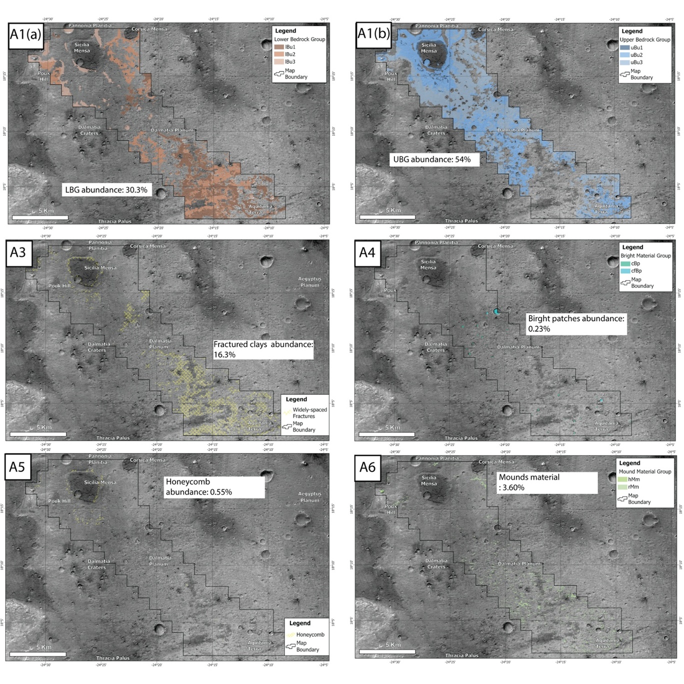
Figure 1: Group A high-priority features identified from orbital data and their abundances within the landing ellipse.
Exploration prioritisation: To integrate scientific value with operational feasibility, we introduce a feature prioritisation framework that evaluates targets based on two parameters: scientific interest (aligned with the Science Sampling Plan, SSP) and likelihood of rover encounter (Fig.2) This approach identifies a “golden spot” where features of high scientific value—particularly those related to the formation and preservation of life on Mars—coincide with a high likelihood of rover encounter. Accordingly, priority targets for rover exploration include Fe–Mg phyllosilicates, layered units, bright patches, hydrated silica and/or other hydrothermal features (e.g., nodular or porous textures), and potential microbially induced sedimentary structures (MISS), if present at the surface.
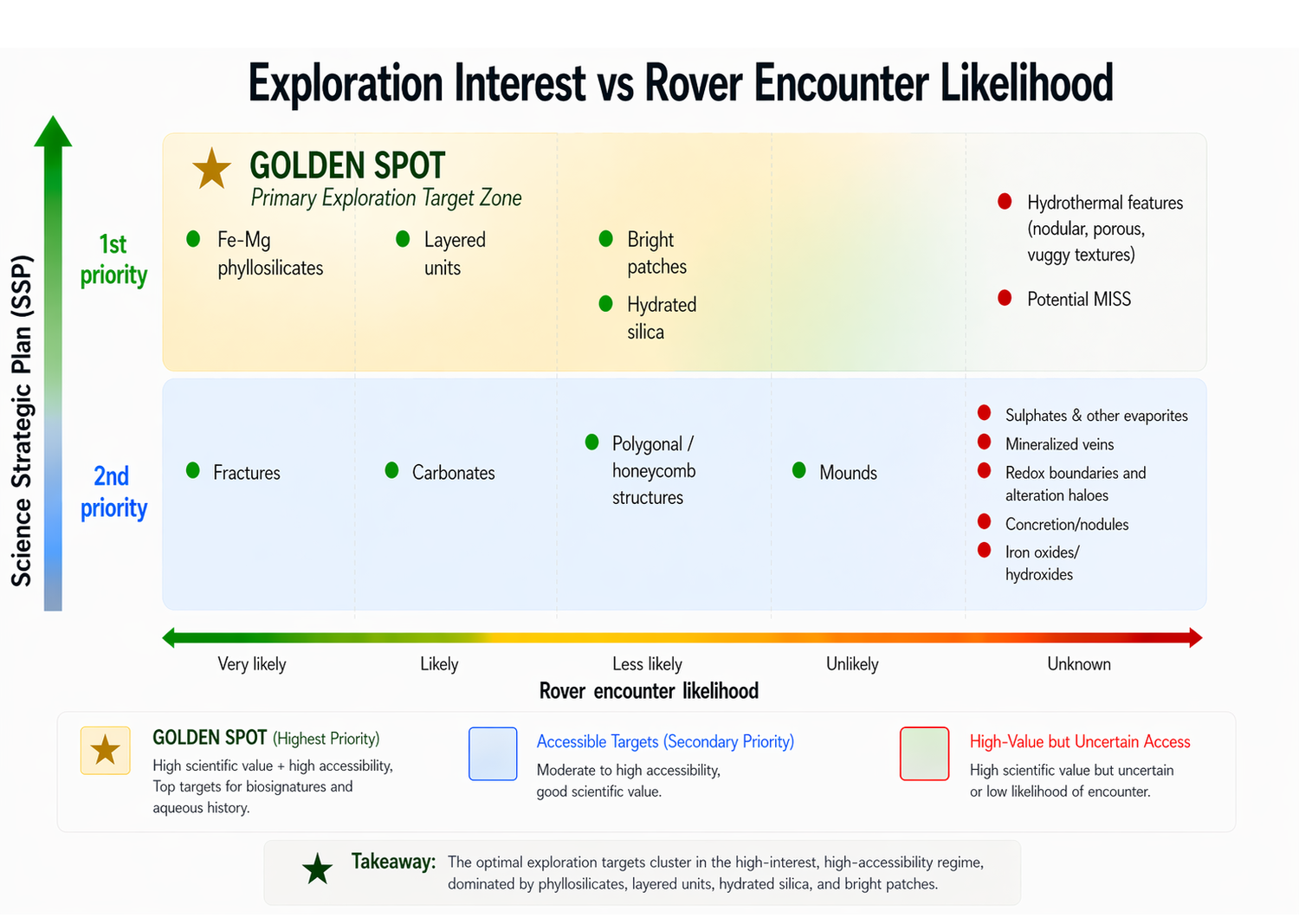
Figure 2: Exploration prioritisation for high priority features at Oxia Planum, their exploration interest based on SSP vs. likelihood of rover encounter.
Science Sampling Strategy (S3): The S3 incorporates high-priority features into a structured operational framework. It defines observations required to characterise geological context, recognise high-priority features in situ, and support sampling decisions.
The strategy is organised into three sequential stages (Fig.3). Observations are acquired across multiple spatial scales, from landscape context (PanCam WAC, NavCam, WISDOM)[6,7] to outcrop and target-scale investigations (PanCam HRC, CLUPI, Enfys)[6,8], with subsurface information provided by WISDOM [7] and Ma_Miss [9] (down to ~2 m depth). Interpretation integrates morphological, stratigraphic, and mineralogical data to reconstruct palaeoenvironmental conditions and assess biosignature preservation potential. Decision-making links these observations to operational decisions, including “stay or go” at a site, “go/no-go for drilling”, and drilling depth selection.
This workflow ensures observations are acquired and evaluated, enabling efficient decision-making. A key strength of the S3 framework is its adaptability. While anchored in orbital predictions, it allows incorporation of newly identified features, addressing uncertainties in orbital interpretations. S3 aims for consistency in preparing for decisions made in operations, so that decision-makers are provided with at least the minimum essential level of supporting information about a certain site or feature.
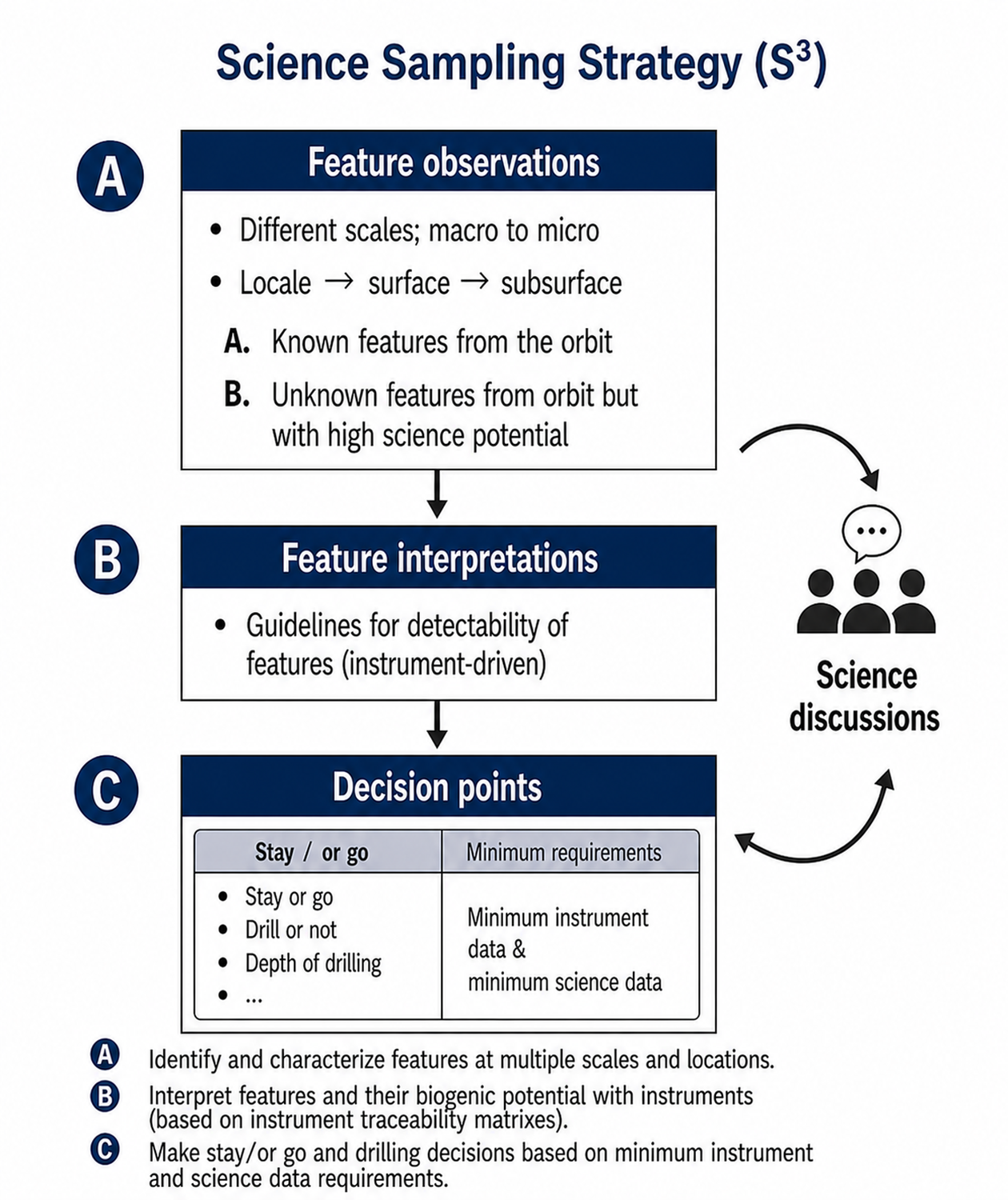
Figure 3: Science Sampling Strategy (S3) workflow.
Conclusions and preparations for operations : We present a Science Sampling Strategy (S3) that links high-priority geological targets at Oxia Planum with a structured, instrument-driven operational workflow for the Rosalind Franklin rover. The strategy enhances science-driven decision-making during rover operations and maximises mission return by focusing on environments most favourable for biosignature preservation.
The S3 will be further refined and validated through upcoming simulation campaigns and operational testing. In the near-term, it will be tested in the first of two ExoMars rover Field Tests, planned for mid-September 2026, providing a critical step toward readiness for surface mission operations.
References: [1] Vago, J. L. et al. (2017) Astrobiology 17, 471–510. [2] Quantin-Nataf, C. et al. (2021) Astrobiology, 21(3), pp.345-366. [3] Torres-Auré, I. et al. (2026). Clay continuity between Oxia Planum and Mawrth Vallis. Icarus, 117113.[4] Fawdon, P. et al. (2024) Journal of Maps, 20(1), p.2302361. [5] McNeil, J.D. et al. (2025) Journal of Geophysical Research: Planets, 130(9), p.e2025JE008989. [6] Coates, A. J. et al. (2017) Astrobiology 17, 511–541. [7] Ciarletti, V. et al. (2017) Astrobiology 17, 565–584. [8] Josset, J.-L. et al. (2017) Astrobiology 17, 595–61. [9] De Sanctis, M. C. et al. (2017) Astrobiology 17, 612–620.
How to cite: Ligeza, G., Sefton-Nash, E., Orgel, C., and Vago, J. L.: Science Sampling Strategy (S3) for High-Priority Features for the ExoMars Rosalind Franklin Rover – Where are They and How to Identify Them?, Europlanet Science Congress 2026, The Hague, The Netherlands, 7–11 Sep 2026, EPSC2026-152, https://doi.org/10.5194/epsc2026-152, 2026.


