

- University of Arizona, LPL, Planetary Sciences, Tucson, United States of America (amcewen@arizona.edu)
The High-Resolution Imaging Science Experiment (HiRISE) camera, orbiting Mars since 2006 on the Mars Reconnaissance Orbiter (MRO), has returned more than 102,000 large (gigapixel) images with scales as small as 25 cm/pixel covering 5.2% of the Martian surface. About 20% of these images are parts of stereo pairs providing 10000 anaglyphs of the martian surface. The HiRISE team has created over 1200 stereo Digital Terrain Models (DTMs; Figure 1) that provide the highest-resolution (1 m/px) planetary topography from orbit. HiRISE uses time delay integration (TDI) to image at a high signal-to-noise ratio in spite of the small view of each pixel and the fast groundtrack velocity. Thanks to our community targeting, rapid data release policy, and open distribution of analysis tools, the scientific impact of HiRISE has been extraordinarily high. A search for "HiRISE" and "Mars" in NASA ADS on 5 May 2026 yielded 2,687 refereed publications. There are 638 refereed publications from 2/2024 to 5/5/2026, published since the summary by McEwen et al. (2024, Icarus 419, id.115795). HiRISE has scouted and certified the landing sites for the Phoenix and InSight landers and the Curiosity, Perseverance, and Rosalind Franklin rovers. Furthermore, HiRISE images have helped to diagnose several failed landing attempts, allowed the Opportunity rover to avoid sand traps, monitored dust accumulation on Insight’s solar panels, and enabled Curiosity to choose drive paths to minimize wheel damage. HiRISE science results can be put into several major categories:
- Ancient Mars alteration: Widespread aqueous mineral alteration of ancient martian crust (and limited exposures of younger crust) has been a paradigm change over recent decades from orbiting spectrometers and other data. HiRISE data, especially with DTMs, enable placing the compositional data into stratigraphic context and extrapolation of some mineral exposures to smaller scales via the color data.
- Geologic processes: There have been hundreds of studies of martian stratigraphic, volcanic (lava and mud), impact, fluvial, mass wasting, tectonic, aeolian, glacial, and periglacial processes. Typically these studies use multiple datasets, but HiRISE provides the highest resolution views except where there have been successful landers, rovers, and drones.
- Ice in the mid latitudes forms an important climatic record and resource for future humans. HiRISE has determined the distribution of buried mid-latitude ice through the imaging of ice-exposing new impact craters including one located as equatorward as 35 N. HiRISE also characterizes thermokarst features that indicate the continued presence of buried excess ice as well as ice-exposing scarps that directly expose this ice.
- Polar science benefits from HiRISE’s polar orbit as well and the high signal-to-noise that its TDI system provides. Stereo DTMs allow for signal analysis of polar layered exposures that show orbital control of Mars’ climate over millions of years. HiRISE shows seasonal CO2 defrosting activity actively changing sand dunes and other surface features today. Dozens of avalanches in progress and mass wasting from polar scarps are measured in HiRISE data. Interannual change in dynamic CO2 ice landforms are measured and can be related to the current climate.
- Current non-polar activity has been shown by HiRISE to be surprisingly common. Dune migration is measured at all latitudes providing information on near-surface winds and the efficacy of aeolian processes today. Modern gully activity has been recorded by HiRISE in enough seasonal detail to determine that seasonal CO2 frost and not liquid water is the responsible agent. Recurring slope lineae mimic the appearance of seeping water tracks on Earth, but HiRISE DTMs and seasonal monitoring showed they are probably narrow thermally-triggered dry landslides. Thousands of newly-formed impact craters have been measured by HiRISE and constrain the present-day impact rate.
- Co-analysis with landed missions has been a part of hundreds of publications. Although landers and rovers provide high-resolution images of very small areas around the surface cameras, HiRISE images and topography provide essential geologic context. For example, the Amapari Marker bed (AMB), for which Curiosity indicated lacustrine deposition, has been mapped around Gale crater with HiRISE data, showing that the lake could have been up to 14-km across (Mondro et al. 2025, JGR Planets 130). In some cases there are dozens of publications even before landing has occurred, such as for the Rosalind Franklin rover.
- Computer vision (or machine learning) has been increasingly important given the very large volume of data from Mars. Such studies have transitioned in recent years from simply demonstrating the potential to producing significant science results. Examples include mapping the global distribution of pitted cones, whose distribution strongly supports an origin as mud eruptions, and finding new impact locations including smaller events where HiRISE can make follow-up diameter measurements, reducing the discrepancy between optical and seismic detections.
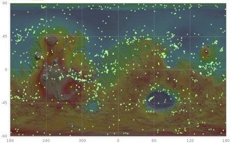
Figure 1. HiRISE DTMs archived with PDS plotted (green squares) on a map of Mars based on MOLA elevations.
How to cite: McEwen, A. and Byrne, S.: 20 Years of Mars Science from MRO HiRISE, Europlanet Science Congress 2026, The Hague, The Netherlands, 7–11 Sep 2026, EPSC2026-169, https://doi.org/10.5194/epsc2026-169, 2026.


