
 1,2,2,3,2,2,2,2,4,
- 1University of Padua, Centro di Ateneo di Studi e Attività Spaziali "Giuseppe Colombo"- CISAS, Padova, Italy (maddalena.faletti@inaf.it)
- 2INAF-Astronomical Observatory of Padua, Vic. Osservatorio 5, 35122, Padova, Italy
- 3Center for Space and Habitability, University of Bern, Gesellschaftsstrasse 6, 3012, Bern, Switzerland
- 4Department of Physics, University of Padua, Via Marzolo 8, 35131, Padova, Italy
- 5Agenzia Spaziale Italiana, Via del Politecnico, 00133, Roma, Italy
- 6Division of Space Research and Planetary Sciences, Sidlerstrasse 5, 3012, Bern, Switzerland
INTRODUCTION
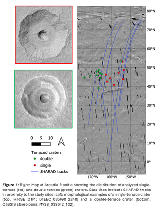
Water ice plays a fundamental role in the geological history of Mars, human exploration, and the search for life. Its distribution constrains paleo-climate interpretations, while sub-surface ice concentrations reveal key depositional processes [1,2]. Impact craters serve as probes into deeper layers; their morphology reflects the mechanical properties and volatile content of the target material. Craters in ice-rich substrates exhibit lower depth-to-diameter ratios (d/D) than those in dry regolith due to differences in target rheology and post-impact viscous relaxation [3]. This effect is most pronounced in simple craters, which are highly sensitive to local substrate properties [4]. Impacts in ice-rich, layered substrate could also lead to the formation of terraced craters, indicative of a strength discontinuity/interface in the subsurface (Figure 1).
This study focuses on simple craters with terraced morphologies in selected martian regions. While some of these features have been mapped locally [2], we leverage high-resolution imagery acquired by several orbiters and convolutional neural networks (CNNs) to substantially expand the existing catalogs, building on our preliminary survey [5]. Our improved dataset, combined with surface topographic data, enables a large-scale, accurate analysis of morphometric properties, such as d/D and terrace dip angles, to better characterize the underlying stratigraphy responsible for terraced crater morphologies.
DATA & METHODS
We performed morphometric analysis on 22 craters in Arcadia Planitia (11 with single and 11 with double terraces) using the catalog by [2]. High-resolution DTMs were generated from HiRISE [6] and CaSSIS [7] stereo pairs; specifically, a dedicated observation campaign planned with the CaSSIS instrument (7-14 June 2025) led to the acquisition of four new stereo pairs. The study sites and the 11 intersecting SHARAD [8] radargrams used to investigate the subsurface structure are illustrated in Figure 1. In addition, CTX [9] images were employed to extend our mapping efforts to other martian regions. The positions of the terraced craters analyzed in this study, as well as those already present in [2], have been integrated into the MATISSE tool of ASI [10].
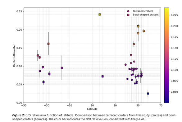
Morphological Analysis: Using QGIS and custom Python scripts, we compared the d/D ratios of terraced craters against a global sample of bowl-shaped craters. To validate the hypothesis of subsurface layering, we are currently using EchoTerraeTrace [11] software to analyze SHARAD data and studies subsurface features.
Deep Learning Algorithm: To expand our current terraced crater dataset, we adopt a supervised CNN-driven mapping approach that is using a YOLOv5x model, following e.g. [12,13]. The model is fine-tuned on manually annotated CTX images, also incorporating negative examples (e.g., bowl-shaped craters) and data augmentation to prevent overfitting. During inference, the CNN generates georeferenced candidate detections with associated model confidence scores; default Non-Maximum Suppression is applied to remove duplicates. Model performance is validated using a withhold test set and Recall, Precision, and Average Precision (AP) [14].
RESULTS
Morphological Analysis: At the same latitude, terraced craters systematically exhibit lower d/D ratios than bowl-shaped ones, suggesting that subsurface ice reduces target material strength during impact (Figure 2). As all considered craters are smaller than 2 km, gravitational collapse processes are limited, making their morphology particularly sensitive to target material properties and volatile content. Variability in terraces number and arrangement further indicates a stratified subsurface with a range of mechanical properties, while shape and asymmetric terraces distribution can reveal impact angle and direction.
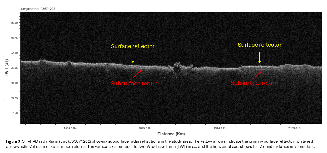
To validate the hypothesis of a layered substrate, we analyze SHARAD radar sounding data to identify subsurface dielectric interfaces (secondary returns); these detections can confirm stratigraphic layering and allow for the estimation of the dielectric constant (εr), providing a direct constraint on composition. Figure 3 illustrates a representative radar echo, differentiating surface and subsurface returns associated with distinct material properties.
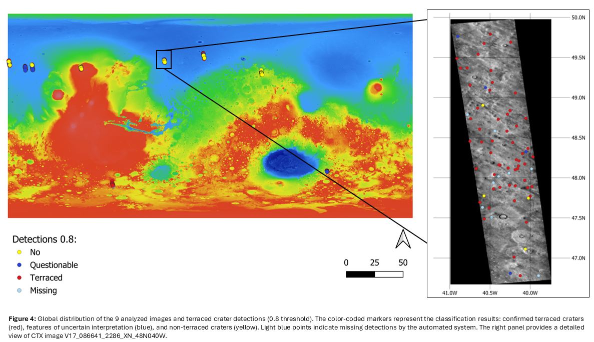
Deep Learning Algorithm: In our withheld test set of 9 CTX images covering the mid-latitudes (Figure 4), the detector effectively distinguished terraced craters from bowl-shaped ones (and other features). At a model confidence of 0.8 and above, the detector identified a total of 350 candidates in the test set, corresponding to a recall of 0.63 (% of terraced craters found) and a precision of 0.92 (% of detections correct).
CONCLUSIONS & FUTURE WORK
The successful evaluation of our terraced craters detector in this initial analysis validates our overall approach of using deep learning to expand our feature catalog across the full longitudinal extent of the northern and southern mid-latitudes (32°-60°N/S) and potentially globally. The goal is to produce a comprehensive new catalog that will provide a robust foundation for further large-scale geographical, morphological, and morphometric studies, integrating both existing datasets and new high-resolution observations, including the planning of additional CaSSIS and HiRISE stereo pair acquisitions.
In support of the automated detection workflow, we employ an established multi-instrumental strategy that integrates morphometric, stratigraphic, and radar data to interpret the martian subsurface. Based on this integrated approach, we are performing a rigorous statistical analysis to identify significant correlations between terrace parameters, dielectric properties, and latitudinal distributions.
ACKNOWLEDGMENTS: This work has been developed under the ASI-INAF agreement n.2024-40-HH.0
REFERENCES: [1] Bramson, Ali M., et al., Geophysical Research Letters 42.16 (2015): 6566-6574.
[2] Bramson, A. M., Shane Byrne, and J. Bapst., Journal of Geophysical Research: Planets 122.11 (2017): 2250-2266.
[3] Douglass, B. S., & Bell, J. F. (2025) LPI Contributions, 3090, 2677.
[4] Robbins, Stuart J., and Brian M. Hynek., Journal of Geophysical Research: Planets 117.E5 (2012).
[5] Faletti, M., et al., EPSC-DPS2025-729, https://doi.org/10.5194/epsc-dps2025-729, 2025.
[6] McEwen, Alfred S., et al., Journal of Geophysical Research: Planets 112.E5 (2007).
[7] Thomas, Nicolas, et al., Space science reviews 212.3 (2017): 1897-1944.
[8] Seu, Roberto, et al., Journal of Geophysical Research: Planets 112.E5 (2007).
[9] Malin, Michael C., et al., Journal of Geophysical Research: Planets 112.E5 (2007).
[10] Zinzi, Angelo, et al., Astronomy and Computing 15 (2016): 16-28.
[11] 10.5281/zenodo.14728638
[12] Bickel, V.T., Nature Communications 16.1 (2025): 9583.
[13] Bickel, V.T., and Valantinas, A., Nature Communications 16.1 (2025): 4315.
[14] Bickel, Valentin Tertius, et al., IEEE Journal of Selected Topics in Applied Earth Observations and Remote Sensing 13 (2020): 2831-2841.
How to cite: Faletti, M., Cremonese, G., Martellato, E., Bickel, V. T., Munaretto, G., Tullo, A., Bertoli, S., Costa, N., Marzari, F., Zinzi, A., Thomas, N., and Pommerol, A.: Terraced craters on mars: morphological and subsurface analysis in arcadia planitia and detection in additional regions via deep learning, Europlanet Science Congress 2026, The Hague, The Netherlands, 7–11 Sep 2026, EPSC2026-235, https://doi.org/10.5194/epsc2026-235, 2026.


