
- Laboratorie de Planétologie Et Géosciences, Nantes Universite, Univ. Angers, Le Mans Universite, CNRS UMR6112, Nantes, France (anna.graugalofre@univ-nantes.fr)
Introduction:
Identifying and characterizing glacial-lake megafloods is key to understand the rapid evolution of the affected landscapes, and offers us a unique view as to what landform assemblages can be identified in Mars’ outflow channels. Here we provide field and remote sensing-based reconstructions of a megaflood that followed the catastrophic collapse of former glacial lake Argentino in the Santa Cruz province, Patagonia [1,2].
In detail, we (1) identify possible megaflood landforms within the Santa Cruz river from remote sensing data; (2) describe field observations; (3) provide a geomorphological map, and (4) suggest a chronology of events [2,3]. Like the Channeled Scablands, the classical analogue for Mars’ outflow channels [4,5], the Santa Cruz river megaflood provides an interesting analogue to Kasei Valles on Mars, and allows for a generalization to how megaflood landforms distribute themselves. Our work provides geomorphologic support for catastrophic glacial lake drainage events in Patagonia indicating the role that catastrophic floods played in continental-scale palaeohydrology.
Setting:
The Santa Cruz river sources from the glacial lake Argentino (50.2S, 72W), fed from the Southern Patagonian Ice Sheet (SPIS). Over the course of the Quaternary, the lake Argentino has been dammed repeatedly by terminal moraines, of which five sets correspond to distinct glacial Santages: El Tranquilo II (36.6 kyr) and I (44.5 kyr), Arroyo Verde II (176 kyr) and I (age unknown), and the Fructuosa (age unknown) moraine [1], in order of distance along the river (Fig. 1).
Methods:
Our field observations follow provincial routes 9 and 4 along the Santa Cruz river southern border, from the Argentino lake to Condor Cliff (50.2S, 70.8W). Our study zone is defined by this length, and spans from the northern to the southern valley rim. Field observations include stratigraphy, landform granulometry, relief, flow direction, and local chronologic relationships.
Remote sensing observations use image data from Maxar (30 cm/px) available in ArcPro, and topographic data, available in open format from the government of Argentina. To identify megaflood-related landforms we used analogies with well-characterized forms in the Channeled Scablands [4,5]. We produced a geomorphological map of the region integrating the field data with the remote sensing data. Our map integrates previous glacial geomorphological data as well as age dates from the diverse river terraces [2,3] into our field and remote sensing observations.
Remote sensing observations:
We identified the following megaflood landforms [5] from remote sensing data (Fig. 1):
Megaripples – Mesoscale (~100m wavelength) ripple deposits found transverse to paleoflow direction with granulometry consisting of cyclic gravel, sand, and clay [5].
Longitudinal bars: Streamlined hill macro deposits composed of sand, gravel, and boulders, elongated along flow direction [5].
Butte and basin topography: small reticulate channels and potholes surrounding buttes and mesas, carved into basaltic bedrock [5]. This landform was carved by steady giant eddies (kolks).
Coulees/ Cataracts: large, steep-walled, theatre-shaped dry canyons, which acted as spillways and flood channels of the overall scabland plexus [5].
Field observations:
Field sites are shown in Fig.1, numbered from 1-11 (landforms). Sites 1-3 targeted a longitudinal bar and its geomorphological context. From bottom to top (~70m), granulometry evolved from sand and loess to gravel and boulders, alternating cyclically upwards. Sites 8-9 were located at the top a ~200m thick basaltic flow incised by potholes and reticulate depressions, leading into a theatre-shaped, dry fall canyon hanging over, and draining into the Santa Cruz river (site 9). Sites 10-11 target cyclic bedforms with wavelengths ~70-90m, displaying changes in granulometry ranging from rounded gravels at the crests to silt and sand in the troughs. Bedform relief is submetric. Sediment deposits delivered from the canyon were both overlying and entrained in these forms. We interpreted sites 1-3 as a longitudinal bar, site 8 as butte and basin topography, site 9 as a cataract/coulee, and sites 10-11 as megaripples.
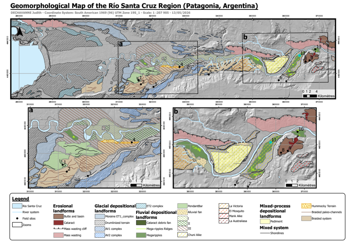
Fig.1 Geomorphological map of the study region (top) and two zoomed insets in zones (a) and (b).
We visited 5 road cuts, of which we describe site 3 (Fig. 1). This cut displays a stratigraphy consisting of a massive basal silt deposit with evidence for deformation. We interpret this as a glaciotectonized, glaciolacustrine unit. Separated by an erosional unconformity, we find a horizontal 1-2m thick layer consisting of meter-scale well-rounded boulders, with long-axis pointing downvalley. The matrix is supported by well-rounded gravel and smaller boulders. Conformally overlying this layer we find layers of well-rounded ~30cm boulders, vertically separated by cyclic silt and sand lenses that were not horizontally continuous beyond ~1-2m. We interpreted this outcrop to be megaflood-transported bedload eroding and overlaying a previous glaciolacustrine deposit.
Discussion and Conclusions:
We next provide chronologic constraints on the timing of this megaflood, based on OSL river terrace dates [3] and Be-10 moraine dates [2]. Megaripples are located in the ‘Chuñi Aike’ river terrace, dated 240 kyr [3]. This age is consistent, within error margins, with the Arroyo Verde II moraines [2], although we cannot discard an Arroyo I event given the lack of age dates.
Our work provides the first complete geomorphological reconstruction and age constrain of the Santa Cruz river megaflood, identifying characteristic megaflood landforms in a different setting than the Channeled Scablands, and offering a clear path of landform assemblages and associations to be expected within Kasei Valles.
Acknowledgments:
This project has received funding from the European Research Council (ERC) under the European Union’s Horizon Europe research and innovation programme (Grant agreement No. 101165197 ICEFLOODS).
References:
[1] Strelin and Malagnino (2009), Revista de la Asociación Geológica Argentina, 64(1).; [2] Romero et al., (2024) Clim. Past, 20, 1861–1883.; [3] Milanes Fernandez et al., 2025 Geology 54(2), pp.117-122.; [4] Baker and Milton (1974) Icarus, 23(1), pp.27-41.; [5] Baker (2009) An. Rev. of Earth and Planetary Sci., 37(1), pp.393-411.
How to cite: Dechavanne, J., Mahoume, N., Vaugeois, G., and Grau Galofre, A.: Field evidence for a glacial-lake outburst megaflood in the Santa Cruz River, Patagonia: An analogue for outflow channel formation, Europlanet Science Congress 2026, The Hague, The Netherlands, 7–11 Sep 2026, EPSC2026-398, https://doi.org/10.5194/epsc2026-398, 2026.


