

- Natural History Museum, London, United Kingdom (joe.mcneil@nhm.ac.uk)
Introduction
The Colour and Stereo Surface Imaging System (CaSSIS [1]) onboard ESA’s Trace Gas Orbiter (TGO) is a multispectral camera that collects images of the surface at 4–5 m/pixel, in blue (BLU, ~480 nm), panchromatic (PAN, ~677 nm), red (RED, ~836 nm) and near-infrared (NIR, ~939 nm) filters across Visible/Near-Infrared wavelengths. CaSSIS has been operational since 2016, and in that time has collated an image database [2] with ~4.4% unique coverage of the surface in all four bands. Although not a spectrometer, CaSSIS has been shown to be capable of differentiating between ferrous and ferric materials and has become an invaluable mapping and context tool in Mars planetary science. CaSSIS and High Resolution Imaging Science Experiment (HiRISE [3]) operational targeting currently relies primarily on panchromatic Context Camera (CTX) or Thermal Emission Imaging System (THEMIS) basemaps, leaving the colour and compositional character of the surface unknown prior to acquisition.
The Compact Reconnaissance Imaging Spectrometer for Mars (CRISM [4]) onboard the Mars Reconnaissance Orbiter has provided near-global visible-to-near-infrared (VNIR) coverage through its mapping-mode Visible/Near-Infrared Reduced Data Records (VRDRs): mosaicked 5°×5° tiles spanning >99% of the surface at ~90 m/pixel across 92 spectral channels [5-7]. By resampling each VRDR pixel spectrum with the CaSSIS filter response functions, we have produced the CaSSIS Resampled Data Record (CaRDR): a simulated four-band CaSSIS-style view of the martian surface at ~90 m/pixel with near-global coverage (Figure 1), providing instrument planners with foreknowledge of surface colour prior to high-resolution image acquisition, and unlocking new global-regional compositional investigative opportunities [8].
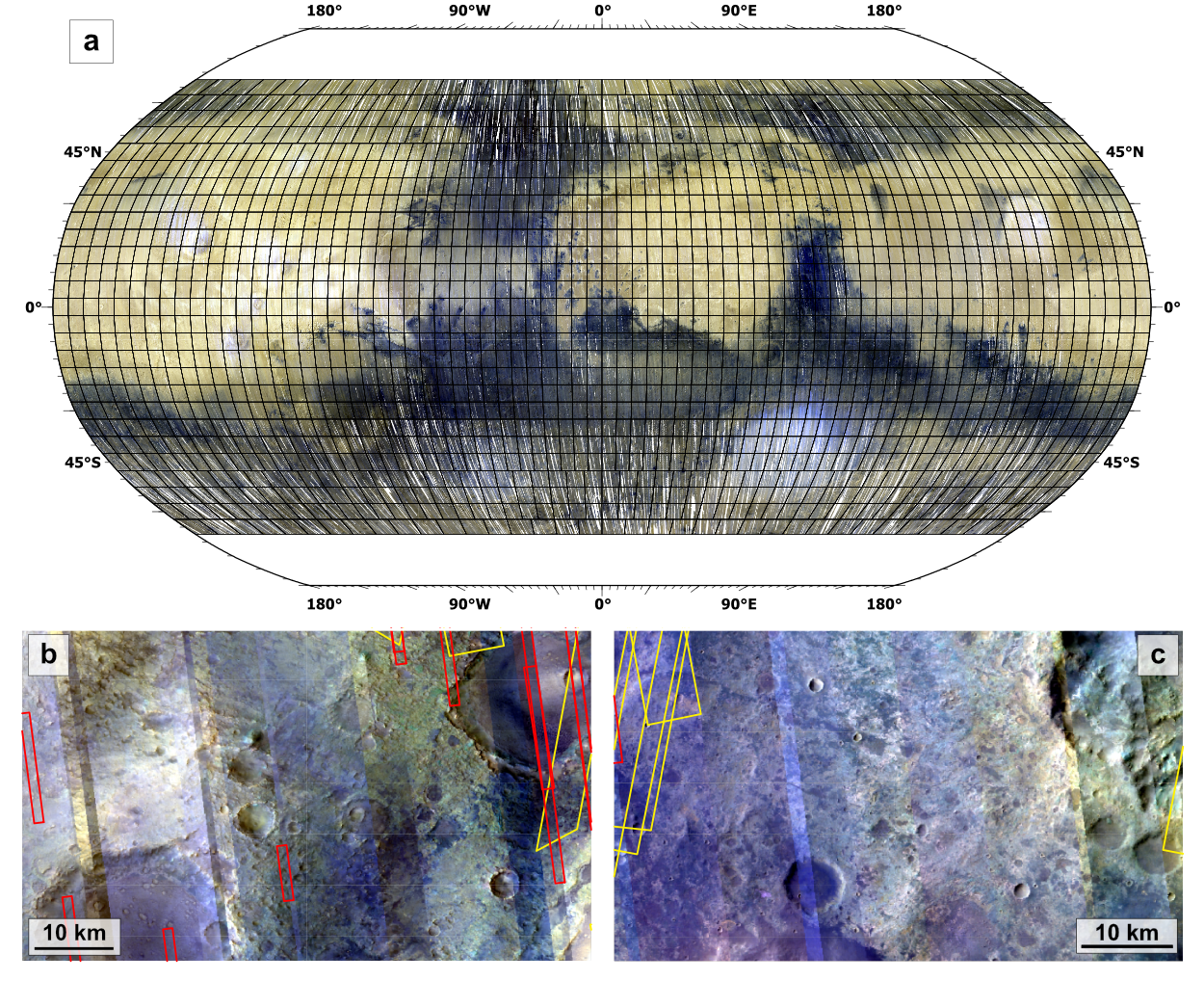
Figure 1: a) The Global CaRDR Dataset in NIR-PAN-BLU, simulating CaSSIS colours at 90 m/pixel. b) cbtnpb_t1249 (NPB, stretched) in Nili Fossae, showing colorful rugged terrains with diverse mineralogy. c) cbtnpb_t0792 (NPB, stretched) in NW Noachis Terra, showing colourful plains south of Coprates Chasma. Footprints of HiRISE colour (red) and CaSSIS (yellow) are shown to highlight lack of high-resolution colour images in these areas.
Methods
Each of the 1764 VRDR 5°×5° Lambert Albedo tiles were resampled to produce a corresponding CaRDR tile. For each spatial pixel and each CaSSIS channel, the resampled CaRDR value is the normalised dot product of the per-pixel VRDR spectrum with the CaSSIS spectral response function interpolated to the CRISM VNIR spectral domain.
Results
Output CaRDR tiles are 32-bit floating-point four-band GeoTIFFs with ENVI-compatible headers, inheriting the coordinate reference system of the source VRDR tile. For each tile we also compute a Colour Band Ratio Composite (CBRC) spectral parameter cube containing the ratios RED/PAN (RPR), PAN/BLU (PBR), PAN/NIR (PNR), an atmospheric ice index (ICE-ATM), and a surface water ice index (ICE-H₂O), following [9]. A group of 8-bit unsigned integer browse products is provided for each tile: various three-band colour composites available from CaSSIS (NPB, NRB, NRP, RPB), a PAN browse, a synthetic true-colour product, and two CBRC products (CBRC1: RPR-PBR-PNR; CBRC2: RPR-PBR-ICE-ATM). The complete dataset has a total uncompressed volume of ~0.81 TB.
Comparing the t1250 CaRDR tile to a co-registered, Lambert Albedo-corrected CaSSIS image (MY37_024813_159_0) over the spectrally diverse Nili Fossae region demonstrates that four-band surface colour is well reproduced at the hectometre scale. CaRDR-pixel to downsampled CaSSIS-pixel comparison yields a mean signed percentage error of −0.7% across all bands, with per-band means of −8.9% (BLU), +8.1% (PAN), −0.6% (RED), and −1.7% (NIR). Error distributions are approximately Gaussian. Qualitative comparison with the standard VRDR RGB browse product (R: 600nm, G: 530nm, B: 440 nm) confirms that CaRDR NPB composites reveal improved local contrast in bedrock exposures and sun-facing slopes, deeper blue tints in ferrous-bearing units, and smoother apparent inter-strip residuals as a result of the effective ~23-channel averaging inherent in the resampling operation.
New target identification and improvements to instrument operational efficiencies
The CaRDR dataset reveals striking colour diversity across vast areas of the martian surface that have received no prior high-resolution colour coverage from CaSSIS or HiRISE. These include, but are not limited to: rugged, mineralogically diverse regions surrounding Nili Fossae (Figure 1b), colourful plains south of Coprates Chasma containing potential chloride deposits (Figure 1c) [10], and ejecta deposits north of Hellas Planitia exhibiting red-toned outcrops of potentially shock-metamorphosed plagioclase-bearing material [11]. The CaRDR dataset identifies these regions amongst others, as compelling new high-priority targets for CaSSIS, HiRISE, and next-generation orbital imagers.
Additionally, by providing instrument planners with foreknowledge of the approximate CaSSIS-band colour and spectral character of surfaces at the hectometre scale, CaRDRs enable colour-informed footprint placement prior to acquisition of high-resolution CaSSIS or HiRISE images. The dataset will help instrument operational efficiency by helping image planners adjust footprints onto the most spectrally interesting sub-regions of a target, reducing the need for repeat observations.
Conclusions
The CaRDR dataset covers >99% of the martian surface at ~90 m/pixel with a total volume of ~0.81 TB across 1,764 tiles. Lambert Albedo values are reproducible to within ~10% of true CaSSIS observations. The dataset [8] is publicly available at the Natural History Museum Data Portal, and the resampling pipeline is available at github.com/rbstabbins/vrdr_resampler. The CaRDR dataset provides a global spectral baseline against which all future high-resolution colour observations can be contextualised.
References
[1] Thomas et al., Space Sci. Rev., 212, 1897, 2017. [2] Thomas, ESA PSA, doi:10.5270/esa-da0ic0t, 2021. [3] McEwen et al., J. Geophys. Res., 112, E05S02, 2007. [4] Murchie et al., J. Geophys. Res., 112, E05S03, 2007. [5] Murchie et al., NASA PDS, doi:10.17189/QGXH-3R49, 2025. [6] Seelos et al., Icarus, 419, 115612, 2024. [7] Murchie et al., EPSC-DPS2025-136, 2025. [8] McNeil & Stabbins, NHM Data Portal, doi:10.5519/TBYP7PU2, 2026. [9] Tornabene et al., Space Sci. Rev., 214, 18, 2018. [10] Bickel et al., Sci. Data, 11, 845, 2024. [11] McNeil et al., EPSC-DPS2025-617, 2025.
How to cite: McNeil, J. and Stabbins, R.: CaSSIS Goes Global: a Multispectral Colour View of Mars From CRISM-CaSSIS Resampling, Europlanet Science Congress 2026, The Hague, The Netherlands, 7–11 Sep 2026, EPSC2026-443, https://doi.org/10.5194/epsc2026-443, 2026.


