
 ,,
,,- Laboratoire de Planétologie et Géosciences, CNRS UMR 6112, Nantes Université, Univ Angers, Le Mans Université, 44000 Nantes, France(stephane.lemouelic@univ-nantes.fr)
Virtual Reality (VR) headsets provide a way to explore distant planets such as Mars or the Moon using orbital and in situ imagery [e.g. 1, 2]. The VR immersion is particularly useful for several aspects. It allows to easily visualize, manipulate and navigate large data sets, using hand controllers. It also allows to visualize geomorphological landforms without the deformations induced by reprojections on flat screens. The VR environment generally provides a better sense of scales, and facilitates the recognition of patterns and relationships between different geological units, thanks to the versatility of the real time choice of the viewpoints by the user.
In order to illustrate this, we have developed two VR experiences to freely fly over two well-known martian landforms, Kasei Valles and Olympus Mons. Kasei Valles, the largest martian outflow channel, is hypothesized to be the result of ancient megafloods, released upon successive catastrophic collapses of a source frozen aquifer. Kasei Valles’ main erosional events date from the Amazonian period, a time marked by the end of previous mild conditions allowing for surface water stability [3, 4]. However, the scale, bedforms, location, and timing of the formation of Kasei Valles challenge its interpretation as solely the result of megaflooding [5], leading us to revisit the hypothesis that ice streams, that is, fast flowing megaglaciers, may have played a substantial role in its formation [6]. Our VR experience provides information within the framework of the “IceFloods” project [6], by helping to gain more understanding on the morphology of the canyon at the global scale, as well as the 3D shape and stratigraphy of streamlined islands [7]. As a second case study, the flanks of the Olympus Mons volcano show several landforms reminiscent of volcanic flows, landslides and past glacial features, which are particularly well expressed once seen in VR.
In order to create the virtual worlds, we used a blended DEM from MGS/MOLA and MEX/HRSC at 200m/pixel coming from Astropedia [8]. Various textures were evaluated, such as extracts of a 76 meter/pixel global color mosaic derived from the Tianwen-1 MoRIC camera [9] or the Mars Odissey THEMIS-IR daytime infrared mosaic at 100 meter/pixel [10]. The two study areas were covered using tiles of 2048x2048 pixels for the DEM and tiles of 8192x8192 pixels for the corresponding textures. These tiles were used to define a set of build-in “terrain” objects in the Unity game engine, which we used for the rendering. Instead of displaying the natural colors, we used linear stretches to better emphasize subtle morphological features. THEMIS data were artificially colorized using RGB values extracted from a typical OMEGA spectrum of Mars.
Kasei Valles (Figure 1) is covered by 4x4 tiles, corresponding to a surface of 1638x1638 km. Olympus Mons (Figure 2) is covered by 2x2 tiles, corresponding to an area of 819x819 km. The two VR scenes were compiled separately in order to provide a standalone executable running on a PC equipped with a VR headset such as the Quest 3 (used for this test).
Further works: in this first version, we did not account for the curvature of the planet. We also plan to locally integrate data at higher spatial resolution such as CTX, CASSIS or HiRISE to emphasize areas of geological interest, which are particularly relevant for the Kasei origin investigation.
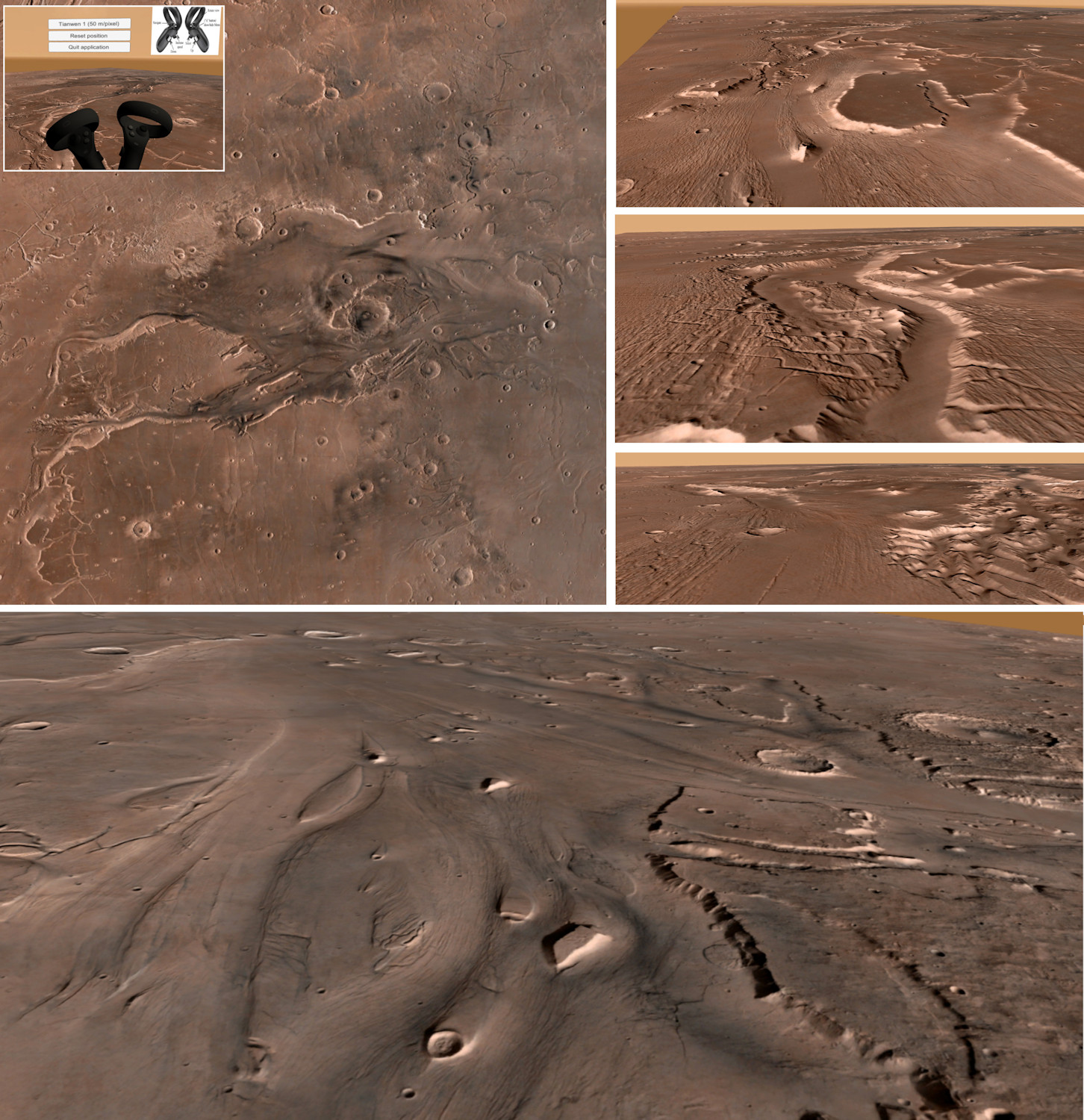
Figure 1: Preview of the Kasei Valles VR experience. The upper left panel shows the footprint of the terrain seen from above. The user can freely navigate using hand controllers (shown in the upper left inset). Examples of the real time rendering of the landscape are given in the side panels. The three upper right panels provide 3D context views of the grooved terrain inside Kasei Valles, whereas the bottom panel offers an oblique view of streamlined island morphometry and characteristics.
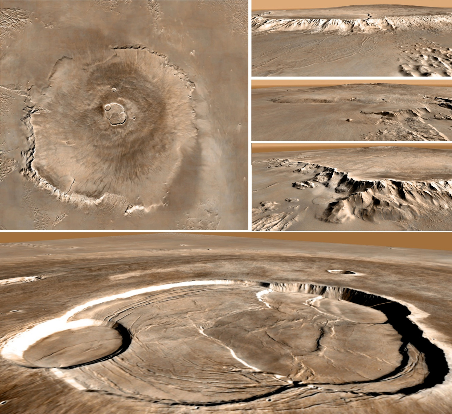
Figure 2: Preview of the Olympus Mons VR experience. The upper left panel shows the complete scene seen from above. Side views illustrate the rendering along the path, freely selected by the VR user using its hand controllers.
Acknowledgments
This project has received funding from the European Research Council (ERC) under the European Union’s Horizon Europe research and innovation program (Grant agreement No. 101165197 ICEFLOODS).
References
[1] Caravaca, G. et al. (2020), 3D digital outcrop model reconstruction of the Kimberley outcrop (Gale crater, Mars) and its integration into Virtual Reality for simulated geological analysis, Planet. Space Sci., 182, 104808, doi:10.1016/j.pss.2019.104808
[2] Le Mouélic, S. et al. (2024), Photogrammetric 3D reconstruction of Apollo 17 Station 6: From boulders to lunar rock samples integrated into virtual reality, Planet. Space Sci., 240, doi:10.1016/j.pss.2023.105813.
[3] Baker, V.R. and Milton, D.J. (1974). Erosion by catastrophic floods on Mars and Earth. Icarus, 23(1), pp.27-41.
[4] Chapman, M.G. et al. (2010). Amazonian geologic history of the Echus Chasma and Kasei Valles system on Mars: New data and interpretations. Earth and Planetary Science Letters, 294(3-4), pp.238-255.
[5] Leverington, D.W. (2011). A volcanic origin for the outflow channels of Mars: Key evidence and major implications. Geomorphology, 132(3-4), pp.51-75.
[6] Grau Galofre, A. (2025). Glacial Sculpture on Mars’ Ancient Megacanyons: A Presentation of Project ‘Icefloods’. In EPSC-DPS Joint Meeting 2025.
[7] Mahoume, N. et al. (2026) Interrogating the lava hypothesis for the origin of Kasei Valles with analyses of streamlined island morphometry. In EPSC 2026 (This issue).
[8] Fergason, R. L, Hare, T. M., & Laura, J. (2018). HRSC and MOLA Blended Digital Elevation Model at 200m v2. Astrogeology PDS Annex, U.S. Geological Survey. https://astrogeology.usgs.gov/search/map/mars_mgs_mola_mex_hrsc_blended_dem_global_200m
[9] Liu J. et al. (2024), A 76-m per pixel global color image dataset and map of Mars by Tianwen-1, Science Bulletin, 69, 14, pp 2183-2186, doi:10.1016/j.scib.2024.04.045.
[10] Edwards, C. S. et al. (2011), Mosaicking of global planetary image datasets: 1. Techniques and data processing for Thermal Emission Imaging System (THEMIS) multispectral data, JGR, 116, E10008, doi:10.1029/2010JE003755.
How to cite: Le Mouélic, S., Grau Galofre, A., Vaugeois, G., Mahoume, N., and Seignovert, B.: Using Virtual Reality to investigate large scale martian geologic landforms: The case of Kasei Valles and Olympus Mons, Europlanet Science Congress 2026, The Hague, The Netherlands, 7–11 Sep 2026, EPSC2026-445, https://doi.org/10.5194/epsc2026-445, 2026.


