
 1,21,2
- 1Department of Engineering and Geology, G. d’Annunzio University of Chieti–Pescara, Italy (gianluca.chiarolanza@unich.it)
- 2International Research School of Planetary Sciences, G. d’Annunzio University of Chieti–Pescara, Italy
INTRODUCTION
Accurate topographic information will play an important role in the geophysical investigation of Ganymede during ESA’s JUICE mission. Surface topography is particularly relevant for the interpretation of radar sounding observations acquired by the RIME [1] instrument, where Digital Elevation Models (DEMs) can support clutter assessment and subsurface signal interpretation. Topographic information is also expected to support gravity and geodetic investigations performed by the 3GM experiment, including shape characterization at regional scale [2].
Topographic information during the JUICE mission will be provided through the combined contribution of GALA laser altimetry [3] and JANUS stereo imaging [4]. GALA will provide accurate absolute elevation measurements and support global shape and geodetic investigations together with 3GM radio-science measurements. However, applications requiring higher spatial resolution and broader areal coverage, including RIME surface clutter assessment, are more likely to benefit from image-based topographic reconstruction, since the spatial distribution of GALA ground tracks during the flyby phase may be insufficient to provide continuous regional coverage.
DEM generation through stereo imaging from JANUS is therefore expected to play a fundamental role in supporting geophysical investigations. At the same time, the systematic acquisition of suitable JANUS stereopairs during the Ganymede flyby phase may require observation conditions that are complex to satisfy simultaneously with the pointing requirements of other geophysical instruments, particularly for repeated observations needed for stereo reconstruction. As a result, the availability of optimal stereopairs during the flyby phase is still under evaluation.
A possible strategy to mitigate these limitations is the combination of newly acquired JANUS images with legacy datasets from previous missions, including Juno, Galileo, and Voyager imaging systems [5-7]. Such a multi-spacecraft approach nevertheless presents several challenges, since heterogeneous image combinations may present significant differences in spatial resolution, illumination conditions, viewing geometry, and stereo convergence angle. Additional complexity also arises from the different optical characteristics and geometric distortion models of the instruments involved, which may introduce further uncertainties in image co-registration and stereo reconstruction when combining heterogeneous datasets [8]. These factors can affect feature recognition, image matching, stereo triangulation, and ultimately DEM quality.
In a previous preliminary study we proposed evaluating a multi-spacecraft approach for DEM generation on Ganymede by comparing DEMs generated from heterogeneous stereopairs with those derived from conventional single-spacecraft image combinations [9]. Here we present the first progress of that study.
PROGRESS UPDATE AND METHODOLOGICAL IMPROVEMENTS
We expanded the topographic coverage derived from JunoCam stereopairs acquired during Juno’s 7 June 2021 flyby of Ganymede and implemented an updated stereo processing workflow using the Ames Stereo Pipeline [10]. The updated workflow includes refined image pre-processing and the testing of an alternative JunoCam distortion model aimed at improving image co-registration and stereo matching performance. The resulting DEM products provide an improved and more extended single-spacecraft reference dataset, which is undergoing a further expansion through the processing of the remaining JunoCam stereopairs (a sub-area of this DEM is shown in Figure 1). Once completed, this dataset will provide a reference framework for future multi-spacecraft DEM comparisons using overlapping heterogeneous datasets.
In addition to the Enki Catena region investigated in the previous study, the expanded DEM coverage will enable the identification of additional candidate areas suitable for testing heterogeneous stereopairs. These datasets will include combinations characterized by varying ground sampling distances, illumination conditions, and stereo geometries, allowing a systematic assessment of the feasibility, quality, and limitations of multi-spacecraft stereo reconstruction on Ganymede.
This work therefore provides both an updated topographic dataset for geophysical investigations, and a source for evaluating future multi-mission topographic reconstruction strategies during the JUICE flyby phase. The proposed framework may also support future synergistic investigations between JUICE and Europa Clipper at Europa [11], where overlapping flybys could enable similar multi-mission stereo reconstruction approaches for geophysical applications.
ACKNOWLEDGMENTS
G.C. and G.M. acknowledge support from the Italian Space Agency (2023-6-HH.0).
REFERENCES
[1] Bruzzone, L. et al. (2013) IEEE IGARSS, 3907-3910.
[2] De Marchi, F. et al. (2021) Icarus, 354, 114003.
[3] Enya, K. et al. (2022) Adv. Space Res., 69, 2283-2304.
[4] Palumbo, P. et al. (2025) Space Sci. Rev., 221, 32.
[5] Hansen, C. J. et al. (2017) Space Sci. Rev., 213, 475-506.
[6] Belton, M. J. S. (1992) Space Sci. Rev., 60, 413-455.
[7] Smith, B. A. et al. (1977), Space Sci. Rev., 21, 103-127.
[8] Schenk, P. M. and McKinnon, W. B. (2026) 57th LPSC, 1720.
[9] Chiarolanza, G. and Mitri, G. (2025) EPSC-DPS2025-996.
[10] Beyer, R. A. et al. (2018) Earth Space Sci., 5, 537-548.
[11] Pappalardo, R. T. et al. (2024) Space Sci. Rev., 220, 40.
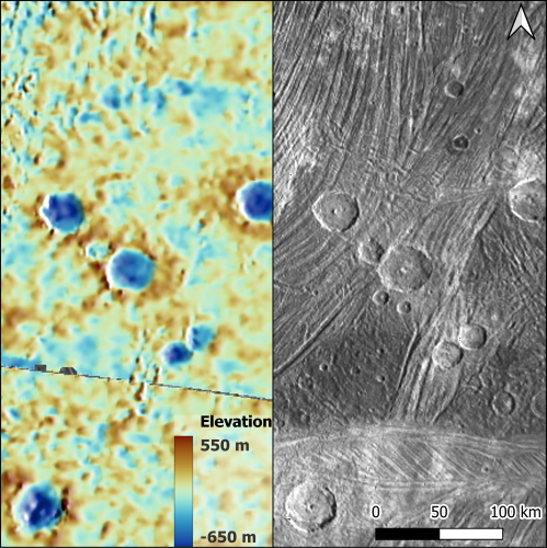
Figure 1: Stereo DEM (left) and orthoimages (right) of a region of Ganymede (22°N, 335°E) imaged by the JunoCam.
How to cite: Chiarolanza, G. and Mitri, G.: Advancing Multi-Spacecraft Topographic Reconstruction on Ganymede for JUICE Geophysical Investigations, Europlanet Science Congress 2026, The Hague, The Netherlands, 7–11 Sep 2026, EPSC2026-459, https://doi.org/10.5194/epsc2026-459, 2026.


