
 3,1,1
3,1,1- 1LATMOS, Université Versailles-Saint-Quentin-en-Yvelines, Guyancourt, France
- 2LATMOS, Sorbonne Université, Paris, France
- 3LGL-TPE, Université Claude Bernard Lyon 1, Lyon, France
- 4SCIENTEAMA, Hérouville-Saint-Clair, France
Introduction
The lunar poles have been identified as key targets for future lunar missions because of the presence of Permanently Shadowed Regions (PSRs), which are thought to uncover large quantities of water ice. In this context, upcoming missions plan to carry Full-Polarimetric Ground Penetrating Radars (FP-GPR), such as the Chang’E 7 Lunar Penetrating Radar [2], and the Lunar Ground Penetrating Radar (LGPR), currently in development at LATMOS [9]. This work focuses on showing the benefit of GPR polarimetric observations for the interpretation of the radargrams in terms of subsurface structures.
CPR: a radar signature of water ice?
The lunar PSRs are located near the poles, where the low obliquity of the Moon with respect to the ecliptic plane prevents direct sun illumination. As a result, the interior of these craters can reach extremely low temperatures, forming long-term cold traps in which water ice may accumulate over geological timescales.
Although the presence of water ice has been confirmed at the surface of the PSRs [1], its occurrence in the subsurface remains under investigation. In 2009, the LCROSS (Lunar Crater Observation and Sensing Satellite) mission crashed a rocket into the Cabeus crater, revealing water in the ejecta plume [3]. Since then, numerous instruments have scrutinized the PSRs, searching for buried water ice.
Synthetic Aperture Radars (SARs), such as Lunar Reconnaissance Orbiter’s Mini-RF or DFSAR onboard Chandrayaan-2, have revealed anomalously high values of Circular Polarization Ratio (CPR) within the PSRs, and have sparked a debate, as they may indicate the presence of water ice, either as a matrix with rocky inclusions or as inclusions within the lunar regolith [8]; but could also arise from depolarizing phenomena unrelated to water ice, such as surface roughness or angular scatterers [7].
Here, the objective is to investigate how in situ FP-GPR measurements can contribute to a better understanding and interpretation of radar polarimetric products, including the CPR.
WISDOM / LGPR, two in-situ FP-GPR
Depending on their operating frequency, FP-GPRs can probe the subsurface to depths ranging from few meters to kilometers, and with vertical resolution spanning from few centimeters to meters. For instance, WISDOM (Water Ice Subsurface Deposit Observation on Mars), the FP-GPR of the ExoMars Rosalind Franklin rover mission, is designed to probe Mars shallow subsurface with a vertical resolution of few centimeters [6]. At LATMOS (France), a successor to WISDOM is currently under development for lunar exploration. Called LGPR, it will operate at lower frequencies to probe larger depths. Given the strong similarities between the two instruments and the availability of data from previous field tests, this study uses WISDOM as the basis for numerical simulations of FP-GPR measurements.
WISDOM is an FP-GPR that operates from 0.5 to 3 GHz. It can transmit and receive in two orthogonal directions of polarizations, providing four polarimetric configurations: 00, 01, 10 and 11 (Fig. 1).
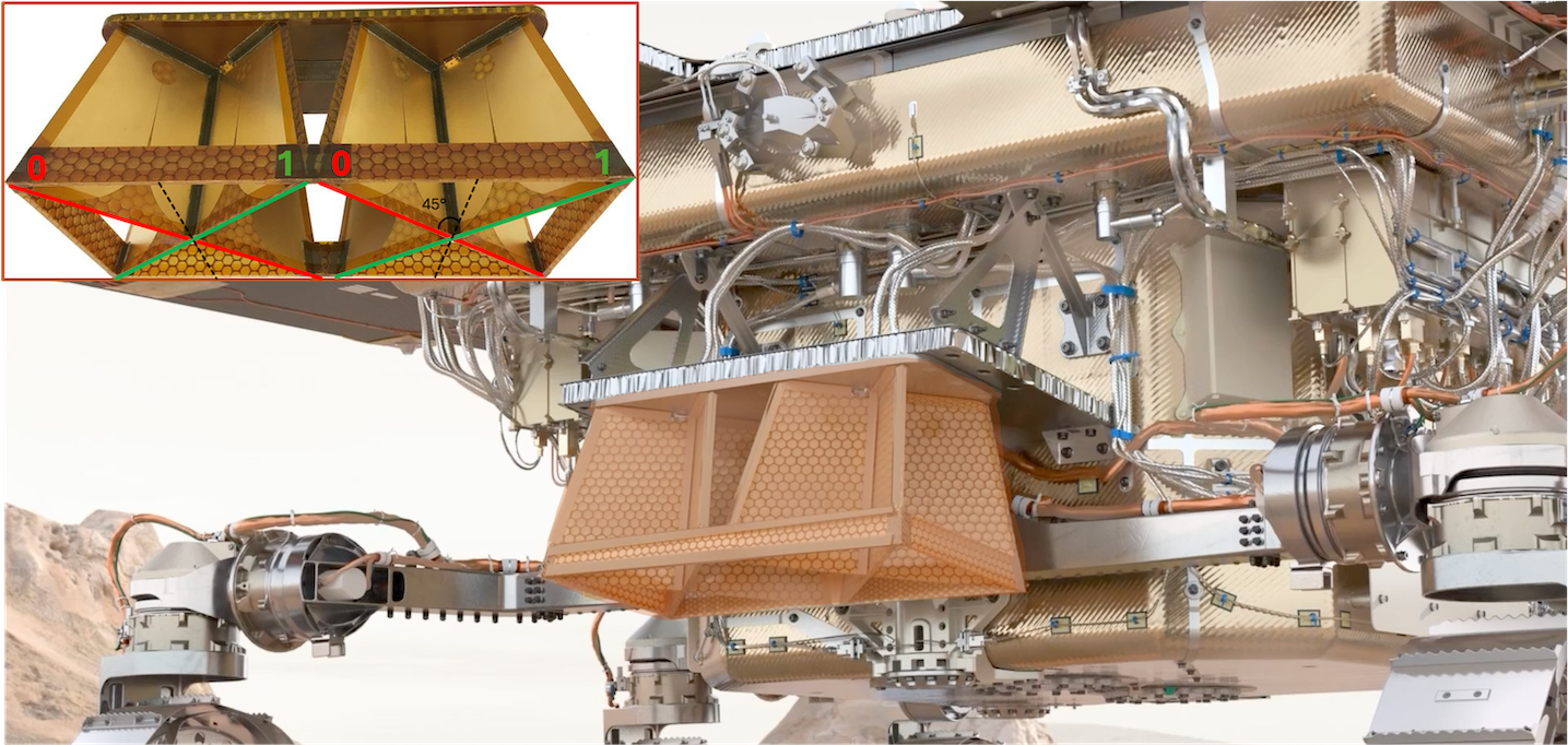
Figure 1: Polarimetric configurations and illustration of WISDOM mounted on the Rosalind Franklin Rover.
Methodology
FP-GPRs can derive a wide range of polarimetric observables, including the CPR, by computing the Stokes Parameters, which are independent of the polarization basis [4]. However, FP-GPRs are often wideband instruments, providing one CPR value for each operating frequency, while orbital radars yield a single CPR value per observation.
As a result, FP-GPRs offer a three-fold analysis of the CPR, developed and investigated for WISDOM/LGPR using numerical simulations and experimental data:
- CPR as a function of frequency
- CPR averaged on the whole frequency band
- Subsurface CPR mapping
A previous study on CPR in icy media containing air and rock inclusions showed that CPR increases both with the number of inclusions, consistent with increasing depolarization phenomena, and with frequency [10]. Building on these results, the present work focuses on the development of subsurface CPR mapping.
Results: from simulations to experimental data
The CPR subsurface mapping approach was tested on simple simulated environments. Figure 2 compares the permittivity distribution of a medium, with heterogeneous/homogeneous layers and smooth interfaces, its RGB radargram (a false-color radargram with 00 in Red, 11 in Green and the average of 01 and 10 in Blue), and the corresponding CPR subsurface map. Smooth interfaces appear yellow in the RGB radargram, and are associated with low CPR values, consistent with weak depolarization. In contrast, heterogeneities produce partial depolarization, appearing cyan or magenta and corresponding to higher CPR values.
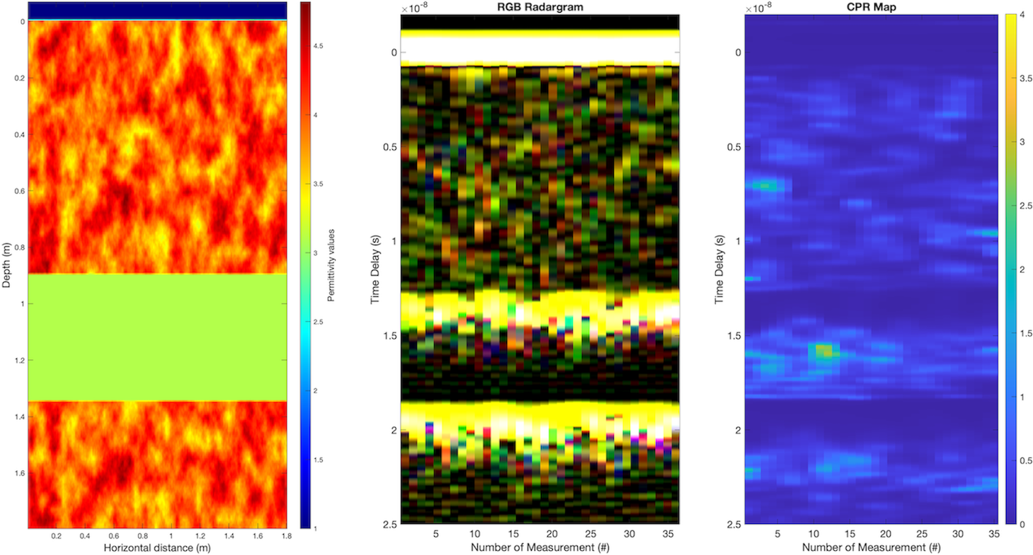
Figure 2: Permittivity distribution, RGB radargram, and CPR map of the simulated medium.
Finally, the subsurface mapping approach was applied to polarimetric data acquired during a WISDOM field test in Svalbard (Arctic Norway), focusing on a profile collected above the meanders of a buried ice cave. Figure 3 shows four regions exhibiting clear depolarization signatures:
- Two regions identified as the ice cave meanders, and a potential meltwater channel (white dashes in Fig. 3). [5]
- Two additional regions of depolarization, difficult to identify in the RGB radargram due to weaker intensity (red dashes in Fig. 3), requiring further investigation.
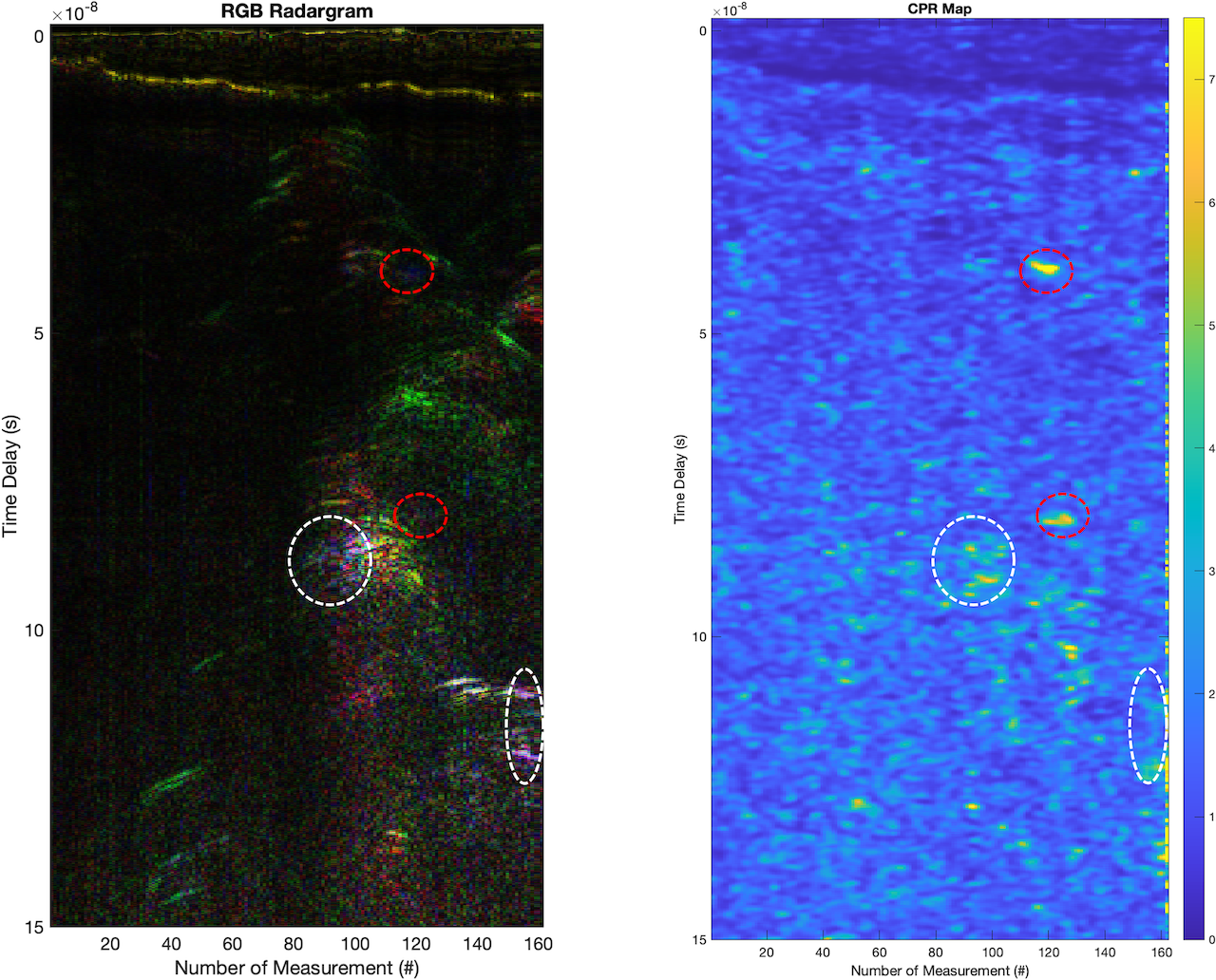
Figure 3: RGB radargram of the ice cave profile, and corresponding CPR map.
These results show the need for a combined quantitative and qualitative approach to identify regions of depolarizations and the complementarity of polarimetric observables.
Conclusion
Results from simulations and experimental data show the advantage of using polarimetric data to better understand subsurface depolarization phenomena from complex media. Next steps involve mapping other polarimetric products such as the degree of polarization, or polarimetric decompositions, but also comparing orbital datasets from Mini-RF with numerical simulations of CPR subsurface maps resulting from FP-GPR measurements at the surface of craters, and orbital simulations.
References
[1] Li et al., 2018, PNAS, 115, 36
[2] Shen et al., 2025, Space Sci Rev, 221, 98
[3] Colaprete et al., 2010, Science 330, 463–468
[4] Raney et al., 2011, IEEE, 99, 808-823
[5] Brighi et al., 2026, submitted in Geophysics
[6] Ciarletti et al., 2017, Astrobiology, 17(6-7), 565–584
[7] Fa et al., 2013, JGR, 118(8), 1582-1608
[8] Spudis et al., 2013, JGR, 118(10), 2016-2029
[9] Le Gall et al., 2026, ELS 2026
[10] Harrar et al., 2025, EPSC-DPS 2025
How to cite: Harrar, L., Le Gall, A., Ciarletti, V., Brighi, E., Hervé, Y., Oudart, N., and Brighi, G.: Towards subsurface mapping of polarimetric products from Full-Polarimetric Ground Penetrating Radar in situ measurements, Europlanet Science Congress 2026, The Hague, The Netherlands, 7–11 Sep 2026, EPSC2026-468, https://doi.org/10.5194/epsc2026-468, 2026.


