
 1,1,1,
- 1The Open University, School of Physical Sciences, United Kingdom
- 2The Open University, School of Environment, Earth and Ecosystem Sciences, United Kingdom
Introduction:
The Hadriacus Cavi are an ~50km long chain of up to 700 m deep depressions, located near the northern rim of Hellas Basin in Mars’ southern highlands1. They are set between high relief mountains to the south, and lower, low relief sedimentary plains to the north. The Cavi themselves record successions of alternating pale and dark layers, probably deposited during the early to middle Noachian, that together are 100s of meters thick2, and generally dip ~1° north-northwest3. Previous work by Skinner et. al. (2021) identified a layer within a 20 km2 region in the western extent of the Cavi containing bedforms which they interpreted to be buried fluvial channels2. It is currently unknown how widespread these channels are throughout the Cavi, or whether they occur in layers other than the one identified by Skinner et al., (2021). Investigating these unknowns will inform our understanding of the fluvial history of early Mars and may reveal more information about the possibility of a past ocean in Hellas basin4.
Methods:
We have used CTX (6m/pixel), HiRISE (25-50 cm/pixel) and CaSSIS (colour; ~4m/pixel) orbital images and Digital Elevation Models (DEMs) in a GIS-based approach. Using ortho-rectified images draped over a series of 1m/pixel HiRISE DEMs we have analysed the regional geology in 3D, creating linework to mark unit boundaries, fluvial structures and other features in the GIS. The wider sedimentary succession in the Cavi was documented, covering an area of ~500 km2, extending into areas beyond that where fluvial structures were first identified2. We have identified multiple potential fluvial structures across the Cavi, based on their morphology, texture and setting and have also documented distinct stratal packages and repeating tonal and textural patterns of strata that extend across the region. The dimensions of the potential fluvial structures and the strata that host them were measured, and we documented any internal structures visible in HiRISE images. We have also begun to measure the dip directions of the strata using 3D GIS tools and to make stratigraphical columns of key areas across the Cavi that will allow us to contextualise the different exposures and channel bearing units.
Preliminary results and interpretation:
We have identified that the fluvial channel deposits postulated by Skinner et al. (2021) extend both laterally and vertically across the Cavi and sit within at least three distinct sedimentary packages. Stratigraphically, these new channels occur both above and below the layer identified by Skinner et al. (2021). The layers are separated by tens to hundreds of metres vertically, and crop out in a series of brighter, steeply dipping cliffs (~40° 3) separated by darker, gently sloping terraces. That they crop out so far from each other stratigraphically suggests that, rather than a single continuous period of fluvial activity, the region experienced multiple episodes of fluvial activity and deposition.
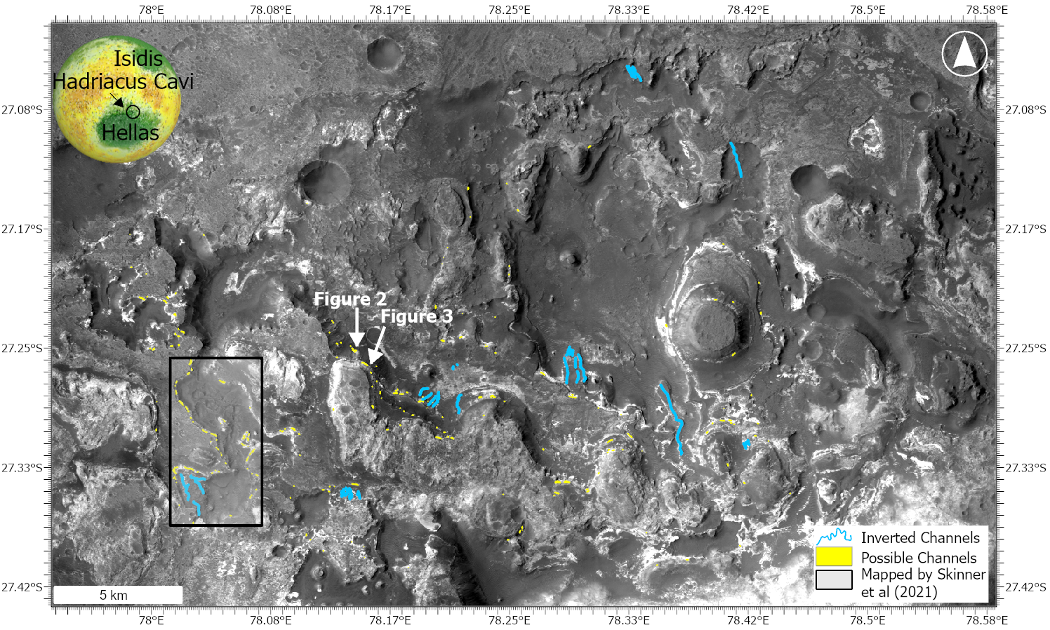
Figure 1: Map of Hadriacus Cavi with inset globe of Mars for context. Yellow polygons indicate possible channel features, blue lines indicate inverted channels. Locations of figures 2 and 3 marked.
Between the fluvial periods, other types of deposition might have dominated, although it is possible that there are other fluvial features which are not currently. We note at least two types of deposit: i) generally flat-topped, curved-bottom features which we interpret as channel deposits2; ii) several examples of a series of dipping layers truncated by flat surfaces that conform to regional bedding at the top and bottom which we interpret as lateral accretion surfaces recording channel migration.
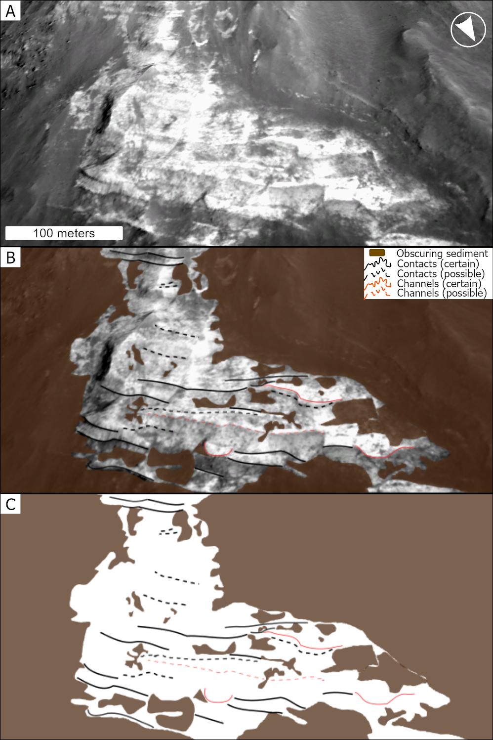
Figure 2: An oblique view of a section of cliff within the Cavi. A) image. B) image and markup denoting fluvial features and sedimentary layers. C) markup only.
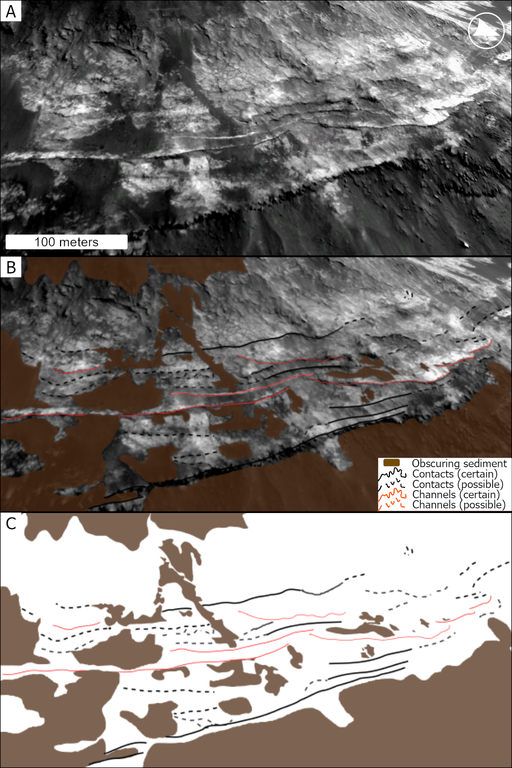
Figure 3: An oblique view of a section of cliff within the Cavi. A) image. B) image and markup denoting locations of fluvial features and sedimentary layers. C) markup only.
The fluvial features are found predominantly in brighter layers and are more common to the west of the study region, though this may be due to higher quality exposures with less overlying cover-material. For the same reason, most channel forms are found in cliffs in the south of the Cavi, those in the north are obscured, shadowed and generally of lower relief than the cliffs to the south. To the east, the bottom of the Cavi pits reveal layers from higher parts of the stratigraphy than seen in the pits to the west, so some of the channel bearing layers (if present) are below ground in the east. We also note the presence of inverted channels in the landscape which occur at the same stratigraphical level as some channels seen in cross section. These can be found across the Cavi and tend to crop out at the same stratigraphical level as the ‘fluvial layer’ first identified by Skinner et al. (2021), supporting the idea that the channel forms are deposits from ancient river systems.
Preliminary conclusions:
We have studied a region more than 500 km2 searching for fluvial channel forms. The channels we have identified are much more laterally extensive and crop out in more strata than those identified previously, being found across the entire 50 km long southern extent of the Cavi. This indicates that the fluvial system or systems which formed these features was more laterally extensive than previously described. One or more larger meandering fluvial systems would explain the diversity in channel form and the range in orientations of various channel forms that we see in the Cavi. Our observations point to either multiple periods of fluvial activity in this region or a long period of fluvial activity. These deposits indicate sustained deposition prior to the more recent processes that have since led to excavation of the Cavi.
References: [1] Smith, D. E. et al. (1999) Science, 284, 1495–1503. [2] Skinner, J.A. et al. (2021) Icarus. 354, 114071. [3] Skinner, J.A. et al., (2017) 48th LPSC, p.2694 [4] Wilson, S.A. et al. (2007) JGR, 112, E8
How to cite: Losekoot, A., Balme, M. R., Fawdon, P., and Coe, A. L.: The Fluvial History of Hadriacus Cavi, Mars, Europlanet Science Congress 2026, The Hague, The Netherlands, 7–11 Sep 2026, EPSC2026-478, https://doi.org/10.5194/epsc2026-478, 2026.


