EPSC Abstracts
Vol. 19, EPSC2026-62, 2026, updated on 02 Jul 2026
https://doi.org/10.5194/epsc2026-62
Europlanet Science Congress 2026
© Author(s) 2026. This work is distributed under the Creative Commons Attribution 4.0 License.

Comparative landform evaluation and visualization in planetary science education
- CSFK, HUN-REN, Konkoly Astronomical Institute, Budapest, Hungary (kereszturi.akos@csfk.mta.hu)
Results from planetary exploration missions in the last decades provided a wide range of knowledge on the occurrence of various landforms on different planetary bodies. Signatures of past volcanic activity was found on Mercury, Venus, Earth, Moon, Mars, Ceres, Vesta, Io, Europa, Ganymedes, Enceladus, Enceladus, Triton, Pluto; while active eruptions were identified on Earth, Io, Europa, Enceladus and Triton, plus inferred indirectly on Venus. Similarly, tectonic features, fluvial, glacial, aeolian and mass wasting related landforms have been identified at many planetary bodies.
Despite the differences in surface gravity, temperature range, characteristics or lack of atmospheres, and variability in material composition, landforms could be classified to resembling groups, which probably formed by similar processes on different bodies. Visualization using various diagrams, comparative figures, cross sectional structures and features found to be useful in the education to present connections are provide Example images are presented below:
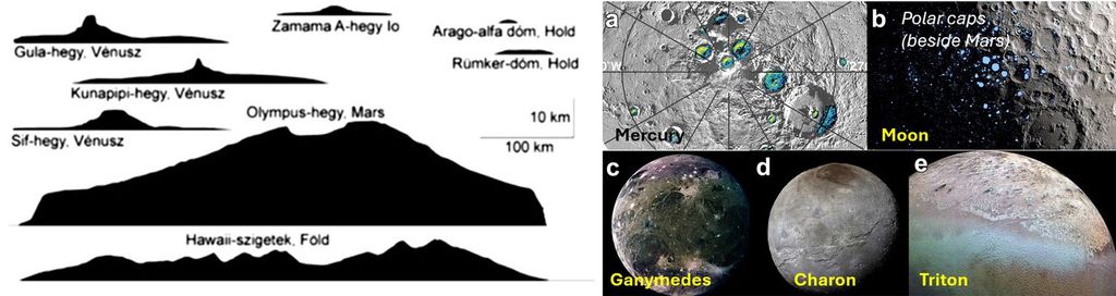
Figure 1 (left): Size comparison of volcanic constructs in Venus(top left), Io (top center), Moon (top right), Mars (center), Earth (bottom); Figure 2 (right): polar icy deposits on various bodies in the Solar System.

Figure 3 (left): Size comparison of volcanic eruption clouds from Io, Mars, Earth and Venus (partly modelled); Figure 4 (right): phase diagram for H2O and CH4 to understand in what format could be present these materials under different conditions of planetary bodies.
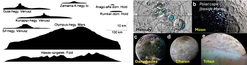
Figure 5 (left): theoretical cross section of the ice crust, liquid water and rocky surface inside Europa satellite, presenting the interaction of various processes; Figure 6 (right): types of effects acting on planetary bodies grouped to internal (centre) and external (around the perimeter) effects, gravitational (below) and radiation (above) effects, from nearby objects (right) and interstellar objects (left).
Comparative images on the size and scale of landforms provide background to present and discuss the reasons for the differences and the reason for the unique realization of various processes. The inferred processes and surface modification modes indicate local conditions including past environmental characteristics. These help not only in the reconstruction of geological history of different planetary bodies, but also widen the background knowledge of students and the general audience. The related synergy supports the connection and joint usage of different curriculum from various school classes too. Example figures and related discussion aspects will be presented at the meeting, which will be accessible for the interested persons.
How to cite: Kereszturi, A.: Comparative landform evaluation and visualization in planetary science education, Europlanet Science Congress 2026, The Hague, The Netherlands, 7–11 Sep 2026, EPSC2026-62, https://doi.org/10.5194/epsc2026-62, 2026.


