
 1,2,1,4,5,
- 1Imperial College London, London, UK (g.g.peres@imperial.ac.uk)
- 2isardSAT, Barcelona, Spain
- 3Royal Holloway, University of London, Egham, UK
- 4European Space Agency, Noordwijk, The Netherlands
- 5Oxford University, Oxford, UK
The Magellan radar space mission [1] produced the largest, highest-resolution, most accurate survey of the surface of Venus to date. During the first cycle of the mission, its unique latitude-varying radar observation geometry allowed for the revisit of morphologically-equivalent terrains with a wide array of incidence angles, both in synthetic aperture radar (SAR) mode and in altimetry mode [2,3,4,5]. With the appropriate constraints and processing steps, this enables the reconstruction of the full scattering behaviour (a scattering curve) of distinct rock units [6] across approx. 0-50 degrees of local incidence, offering a unique opportunity to measure the mean radiometric signature of different terrain formations on Venus and, for the first time, map and characterise wavelength-scale surface roughness across the entire planet. Additionally, the derived scattering curves represent the reference scenarios that will enable radiometric comparison of Magellan SAR images with SAR data from upcoming Venus orbiters, even if the acquisition geometry between sensors for a specific target differs significantly [7,8].
To perform this study, we have built a comprehensive method that blends SAR and altimetry backscatter, postprocessed Magellan topography, Magellan radiometry, and geological data from Venus; the method incorporates a physically-constrained stochastic model of uncertainty for each individual backscatter measurement, and provides the framework for scattering models and constraints to appropriately fit the data. Our scattering curve results have been extensively tested against different cycle 1 and cycle 2 SAR and altimetry data to investigate the heterogeneity and/or isotropy of the measured surfaces, and to internally validate the radiometric consistency (absolute and relative) of the observed backscatter estimates.
In this work, we present insights into our findings regarding surface roughness properties for each terrain formation. We discuss the geological interpretation of the results, linking the scale of the retrieved mean roughness with the most-likely surface modification processes. In particular, we demonstrate the separability of the scattering characteristics of rift zones and Tessera terrain from the several plain units across the planet. Additionally, we globally constrain the predicted backscatter values for the forthcoming SAR missions to Venus. This is a critical step towards robust mission-to-mission SAR image intercomparison, enabling inter-mission SAR change detection from a radiometric perspective [9,10], and a key input to consolidate the on-going radar design, operation and data processing for these missions.
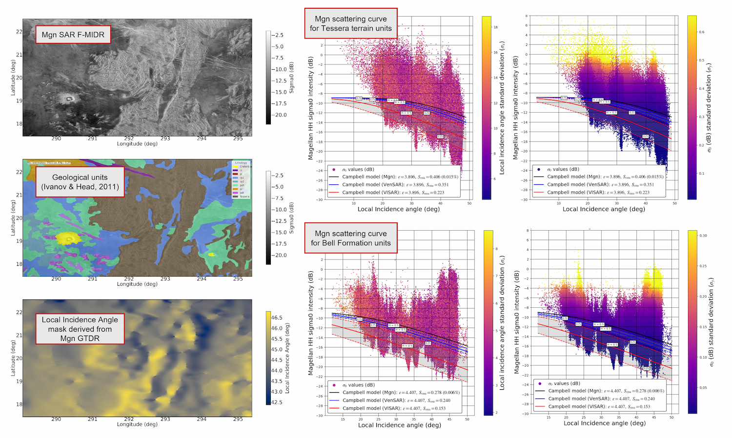
Figure 1. Example summary of diffuse scattering results from Magellan SAR backscatter data of Bell Formation (lava flow) units and Tessera terrain.
[1]. Saunders, R. S., et al. "Magellan mission summary." Journal of Geophysical Research: Planets 97.E8 (1992): 13067-13090.
[2]. Ford, John P. Guide to Magellan image interpretation. National Aeronautics and Space Administration, Jet Propulsion Laboratory, California Institute of Technology, 1993.
[3]. Campbell, Bruce A. Use and presentation of Magellan quantitative data in Venus mapping. No. 95-519. US Geological Survey,, 1995.
[4]. Ford, Peter G., and Gordon H. Pettengill. "Venus topography and kilometer‐scale slopes." Journal of Geophysical Research: Planets 97.E8 (1992): 13103-13114.
[5]. Tyler, G. Leonard, et al. "Scattering properties of the Venusian surface: Preliminary results from Magellan." Journal of Geophysical Research: Planets 97.E8 (1992): 13115-13139.
[6]. Ivanov, Mikhail A., and James W. Head. "Global geological map of Venus." Planetary and Space Science 59.13 (2011): 1559-1600.
[7]. Gallardo i Peres, G., P. J. Mason, and R. Ghail. "An End-To-End Inter-Mission Change Detection Algorithm: Between Magellan and Future VenSAR and VISAR Radar Imagery on Venus." 55th Lunar and Planetary Science Conference. Vol. 3040. 2024.
[8]. Gallardo i Peres, Gerard, et al. "A generalized beta prime distribution as the ratio probability density function for change detection between two SAR intensity images with different number of looks." IEEE Transactions on Geoscience and Remote Sensing 62 (2024): 1-14.
[9]. Gallardo i Peres, G., 2022. A proposed change detection method in the framework of the VERITAS & EnVision radar missions to Venus. MSc Thesis. Denmark Technical University.
[10]. Campbell, Bruce A., and Scott Hensley. "Detecting surface change on Venus from Magellan and VERITAS radar images." Icarus 407 (2024): 115773.
How to cite: Gallardo i Peres, G., Mason, P., Ghail, R., Wilson, C., Straume-Lindner, A. G., Granados, A., and Roca i Aparici, M.: Radar Scattering of Venus Terrains: Characterising Surface Roughness in Preparation for the Decade of Venus, Europlanet Science Congress 2026, The Hague, The Netherlands, 7–11 Sep 2026, EPSC2026-691, https://doi.org/10.5194/epsc2026-691, 2026.


