
 1,2
1,2- 1University of Copenhagen, Niels Bohr Institute, Physics of ice Climate and Earth, Copenhagen, Denmark (iris@nbi.ku.dk), (mosegaard@nbi.ku.dk)
- 2Université Paris Saclay, Institut Universitaire de France, Paris, France (frederic.schmidt@universite-paris-saclay.fr)
The lunar south polar region is a prime target for future robotic and human exploration due to its scientific potential, proximity to permanently shadowed regions that may host volatile deposits, and strategic relevance for sustained surface operations. However, terrain characterization in this environment remains fundamentally challenging. Persistent low solar elevations, extreme local topography, strong shadowing, and pronounced photometric ambiguities complicate conventional orbital terrain reconstruction methods, particularly where accurate topographic information is required at hazard-relevant scales. These limitations are especially critical for landing site assessment, traverse planning, and operational risk analysis, where deterministic terrain products without associated confidence estimates may be misleading. High-resolution topographic mapping in this environment therefore requires not only enhanced spatial detail, but also physically meaningful uncertainty quantification.
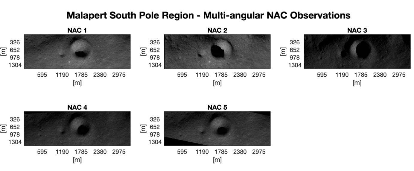
Figure 1 - Multi-angular LROC NAC observations of the Malapert study region acquired under differing illumination and viewing geometries, used as input to the inversion framework.
Here we present a preliminary application of a multi-angular reflectance-constrained inversion framework for uncertainty-aware joint reconstruction of lunar topography and surface reflectance in the Malapert region near the lunar south pole. Malapert provides a compelling test case due to its rugged terrain, challenging illumination environment, and broader relevance to south polar exploration concepts. The analysis combines five Lunar Reconnaissance Orbiter Narrow Angle Camera (LROC NAC) observations (figure 1) acquired under differing illumination and viewing geometries with a substantially coarser reference digital elevation model providing long-wavelength topographic constraints. Surface reflectance is represented using a non-Lambertian Ross–Thick Li–Sparse (RTLS) bidirectional reflectance formulation, allowing anisotropic regolith scattering behaviour to be explicitly incorporated into the inversion. This is particularly important in polar environments, where simplified Lambertian assumptions can introduce systematic biases under extreme illumination geometries.
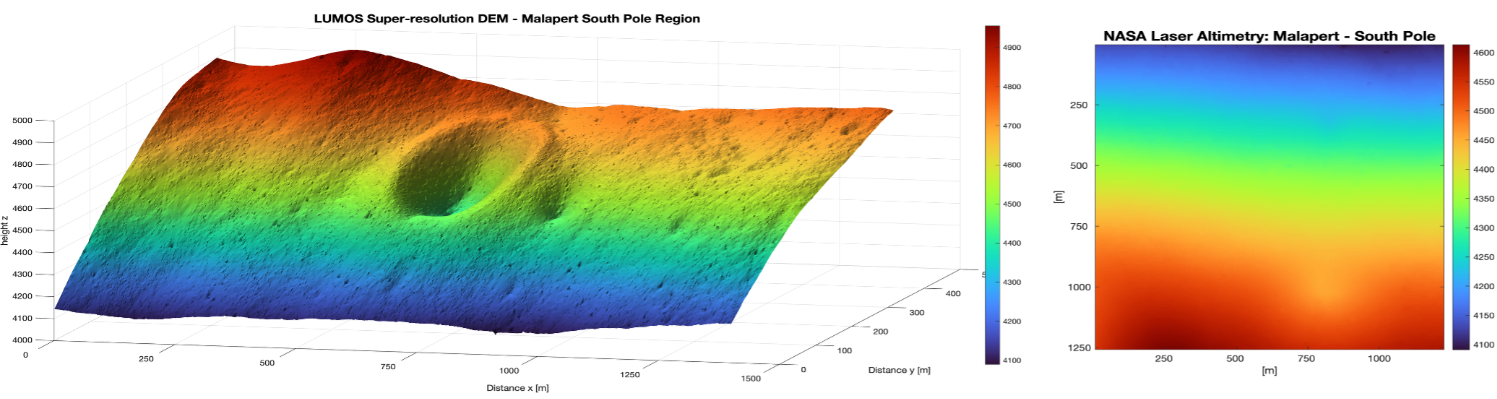
Figure 2 - Comparison between the reconstructed super-resolution topography (left, 1.63 m/pixel) and the lower-resolution reference topographic model (right) providing long-wavelength constraints.
The inversion reconstructs topography at 1.63 m/pixel resolution (figure 2) while simultaneously estimating spatially varying reflectance parameters and associated uncertainty products (figure 3).
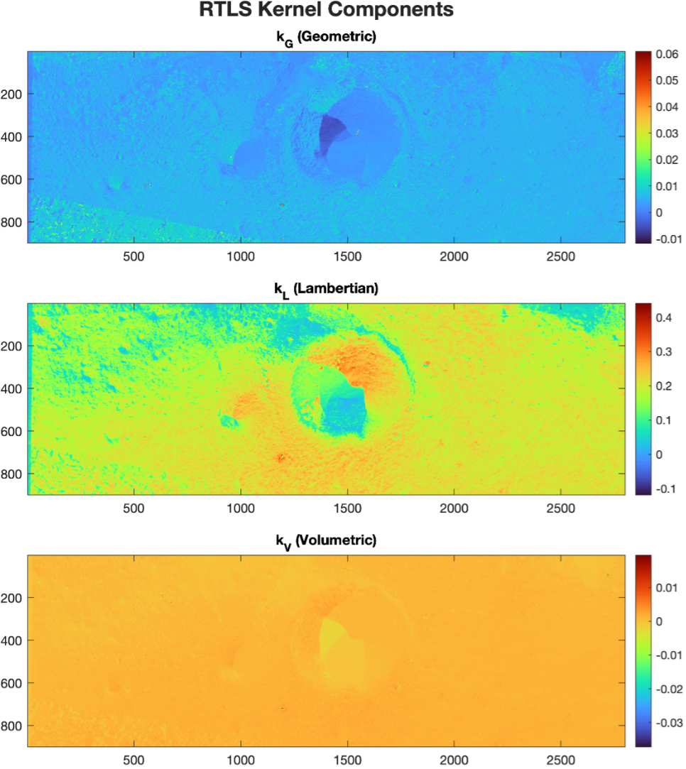
Figure 3 - Retrieved spatially varying RTLS reflectance kernel parameters (kG, kL, and kV) estimated jointly with the topographic reconstruction.
In addition to the reconstructed digital elevation model, we derive slopes (figure 4) uncertainty maps for both elevation and local slope estimates, with slope uncertainty evaluated over a 3.5 × 3.5 m footprint (figure 5) relevant to hazard-scale terrain assessment. The resulting reconstruction resolves fine-scale morphological structure beyond the scale of the long-wavelength reference terrain model, recovering metre-scale terrain variability inaccessible to the prior constraint alone. One-dimensional slope transects extracted across representative terrain further illustrate the sensitivity of local slope characterization to fine-scale morphology and emphasize the importance of resolution enhancement for exploration-relevant terrain analysis.
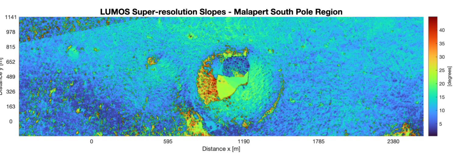
Figure 4 - Reconstructed local slope map of the Malapert study region in degrees, highlighting fine-scale terrain variability relevant to hazard-scale analysis.
Preliminary results demonstrate that uncertainty-aware terrain reconstruction is feasible even under the challenging illumination conditions characteristic of lunar south polar orbital imaging. Spatial uncertainty products distinguish well-constrained terrain from regions where reconstruction confidence is reduced due to weak illumination, limited angular diversity, or reduced photometric sensitivity. This distinction is scientifically and operationally important, as it enables terrain products to be interpreted with explicit awareness of confidence limitations rather than as uniformly reliable deterministic solutions. In parallel, retrieved reflectance parameter maps capture spatial variability in surface photometric behaviour, providing complementary information on surface scattering properties. Comparison of photometric residuals between simplified Lambertian assumptions and the RTLS formulation further highlights the importance of physically realistic reflectance modelling in this environment, demonstrating improved consistency in the inversion when anisotropic scattering is explicitly represented.
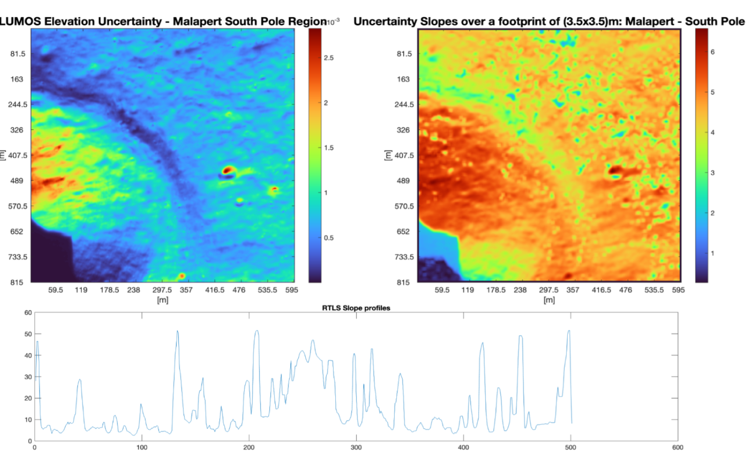
Figure 5 - Uncertainty products and terrain profiling: elevation uncertainty (top left), slope uncertainty evaluated over a 3.5 × 3.5 m footprint (top right), and representative one-dimensional slope profile across the reconstructed terrain (bottom).
Beyond the present LRO-based demonstration, this study directly illustrates the scientific rationale behind ESA’s proposed Máni mission, whose dedicated multi-angular acquisition strategy is specifically designed to improve high-resolution, uncertainty-aware lunar terrain characterization. The present analysis effectively serves as a proof-of-concept using existing orbital data for the observational philosophy that Máni is intended to optimize. South polar applications represent a particularly compelling use case for this approach, where improved characterization of slopes, roughness, and illumination-sensitive terrain could directly support exploration planning while simultaneously enabling new investigations into lunar surface evolution and surface processes under persistent low-illumination conditions.
How to cite: Fernandes, I., Mosegaard, K., and Schmidt, F.: Uncertainty-Aware Super-Resolution Topographic and Reflectance Reconstruction of Lunar South Polar Terrain: A Preliminary Malapert Case Study, Europlanet Science Congress 2026, The Hague, The Netherlands, 7–11 Sep 2026, EPSC2026-731, https://doi.org/10.5194/epsc2026-731, 2026.


