
 1,2,2
1,2,2- 1Link Campus University, Rome, Italy (m.mastrogiuseppe@unilink.it)
- 2Sapienza University of Rome, Italy
- Introduction
The Cassini RADAR altimeter (Ku-band, 13.78 GHz, λ ≈ 2.17 cm) provided the first and so far only direct sounding of Titan's hydrocarbon seas, revealing depths exceeding 160 m in Ligeia Mare and constraining the methane-dominated composition of its northern liquid bodies [1–3]. Bathymetric retrievals rely on detecting weak seafloor echoes following the dominant specular surface return. Conventional sidelobe mitigation through spectral windowing (e.g. Blackman tapering combined with Burg autoregressive extrapolation) suppresses sidelobes at the cost of degraded vertical resolution and reduced signal-to-noise ratio (SNR), limiting detections in shallow basins and near shorelines.
We present a re-analysis of Cassini altimetry based on a two-stage processing pipeline that addresses surface dominance directly, without spectral tapering. The pipeline combines (i) a CLEAN-inspired coherent cancellation of the surface return and (ii) a high-resolution Delay/Doppler focusing of the residual subsurface signal. The joint approach preserves the native ~35 m vertical resolution while improving along-track resolution by nearly an order of magnitude. The complete workflow is illustrated in Fig. 1.
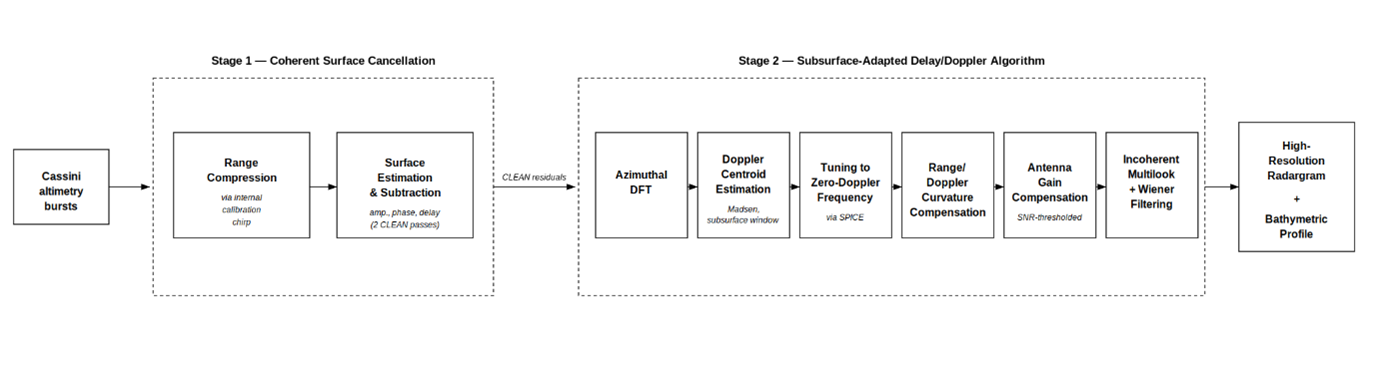
Figure 1. Two-stage processing pipeline applied to Cassini RADAR altimetric data. Stage 1 (left): CLEAN-inspired coherent cancellation of the surface return. Stage 2 (right): subsurface-adapted Delay/Doppler processing of the residual bursts. The final products are a high-resolution radargram and an along-track bathymetric profile.
- Method
Step 1 — Coherent surface cancellation.
For each altimetric burst, the internal calibration chirp—routed directly into the receiver and therefore carrying the full system impulse response—is used as a deterministic replica of the surface return. The complex amplitude, phase, and delay of the surface echo are estimated through cross-correlation between the range-compressed echo and the compressed calibration waveform. A scaled, phase-aligned, and delay-shifted replica of the surface return is then coherently subtracted from the complex waveform on a sample-by-sample basis through CLEAN iterations applied to all bursts. Unlike spectral windowing, this approach removes the dominant surface response without degrading the matched-filter resolution and therefore the SNR.
Step 2 — Subsurface-focused Delay/Doppler processing.
CLEAN-processed residual bursts are focused through a Delay/Doppler Algorithm (DDA) [4,5] adapted for the subsurface regime. The Doppler centroid is estimated within a delay window restricted to the seafloor return, suppressing residual surface contamination, and the burst is retuned to zero-Doppler frequency using SPICE-derived spacecraft state vectors to account for the hyperbolic Cassini flyby geometry. Range/Doppler curvature is then compensated, followed by antenna-gain correction applied selectively to Doppler bins above an SNR threshold, to avoid noise amplification in low-power subsurface regions. Incoherent multilook integration across Doppler-resolved bursts, combined with adaptive Wiener filtering, recovers the SNR loss associated with the reduced number of looks per burst.
- Results
We apply the pipeline to three Cassini altimetric tracks over Titan's polar terrains — T91 (Ligeia Mare), T108 (Punga Mare), and T126 (Winnipeg Lacus) — and present here Winnipeg Lacus as a representative case study. Results for Ligeia and Punga, including the recovery of the seafloor reflector in shallow regions previously inaccessible to conventional Burg+Blackman processing, will be shown in the accompanying poster.
Winnipeg Lacus (T126).
Winnipeg Lacus is a small polar lake (~78.5°N, 155°W) that lies near the Cassini detection threshold in conventional altimetric processing. After Stage 1, coherent cancellation suppresses the specular surface peak by more than 60 dB and reveals a continuous seafloor reflector across the full track. Stage 2 improves along-track resolution from the beam-limited footprint (~6 km) to the sub-kilometer regime, resolving fine-scale variability of the bottom reflector (Fig. 2). The retrieved bathymetric profile reaches ~105 m maximum depth (estimated uncertainty ±6 m), with an asymmetric morphology — gentle eastern slope and steeper western margin — consistent with erosional processes inferred for Titan's empty lake basins. The retrieved depth is in agreement with the bathymetric profile reported in [3], as shown by the direct comparison in Fig. 3, while the higher along-track sampling of the DDA reconstruction resolves slope variations and basin asymmetries unresolved in the reference profile. The high-resolution radargram supports the methane-rich liquid composition and reveals topographic structures hidden so far by conventional processing, complementing the geophysical characterization of the surrounding northern polar terrains derived from multiangular Cassini RADAR inversion [6].
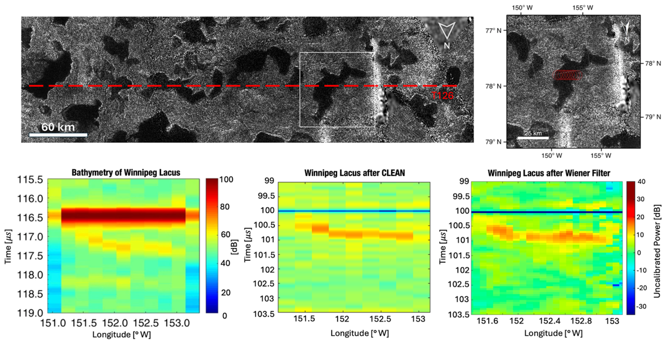
Figure 2. Winnipeg Lacus (T126 flyby): bathymetric reconstruction. (a) Cassini SAR mosaic with the altimetric ground track (red). (b) Radargram from conventional Burg+Blackman processing: the seafloor reflector is barely discernible against the surface sidelobes. (c) Radargram after coherent surface cancellation (Step 1): the surface peak is suppressed by ~60 dB and the seafloor reflector becomes well-defined. (d) Final radargram after Delay/Doppler focusing (Step 2).
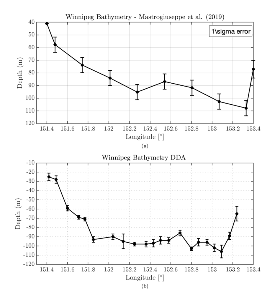
Figure 3. Winnipeg Lacus (T126 flyby). Comparison between bathymetric profiles across the Winnipeg study area. (a) Reference bathymetry from Mastrogiuseppe et al. (2019), with error bars representing the 1σ uncertainty. (b) Bathymetry retrieved using the DDA approach.
- Conclusions
The combined CLEAN + Delay/Doppler pipeline enables high-resolution bathymetric reconstruction of Titan's hydrocarbon seas without the resolution and SNR degradation of conventional tapering-based methods. Applied to the Cassini altimetry archive, the approach has the potential to extend reliable depth retrievals to previously underutilized flybys and refine constraints on the bathymetry, composition, and connectivity of Titan's seas, with direct implications for Titan's methane cycle and for future missions, including Dragonfly.
References
[1] Mastrogiuseppe M. et al. (2014), Geophys. Res. Lett., 41, 1432–1437. [2] Mastrogiuseppe M. et al. (2018), Earth Planet. Sci. Lett., 496, 89–95. [3] Mastrogiuseppe M. et al. (2019), Nat. Astron., 3, 535–542. [4] Raney R. K. (1998), IEEE Trans. Geosci. Remote Sens., 36(5), 1578–1588. [5] Poggiali V. et al. (2019), IEEE Trans. Geosci. Remote Sens., 57(9), 7262–7268. [6] Mastrogiuseppe M. et al. (2026), IEEE Trans. Geosci. Remote Sens., 64, 4500117.
Acknowledgements
This work was supported by the Italian Space Agency (ASI), contract 2025-4-U.0.
How to cite: Mastrogiuseppe, M., Raguso, M. C., Bellucci, S., Rossini, I., and Durante, D.: High-resolution bathymetry of Titan's hydrocarbon seas through coherent surface cancellation and Doppler focusing of Cassini RADAR altimetry, Europlanet Science Congress 2026, The Hague, The Netherlands, 7–11 Sep 2026, EPSC2026-795, https://doi.org/10.5194/epsc2026-795, 2026.


