
 1,2,1,2
- 1Department of Physical Geography, Faculty of Geosciences, Utrecht University, Utrecht, The Netherlands
- 2Laboratoire de Planétologie et Géosciences, Nantes Université, Univ Angers, Le Mans Université, CNRS, Laboratoire de Planétologie et Géosciences, LPG UMR 6112, 44000 Nantes, France
Introduction
Gullies on Mars are a feature prevalent in the mid-latitudes of Mars [1,2]. They are characterised by a source alcove, transport-channel and terminal depositional apron/fan [3]. They are typically large enough to be reliably identified on ~6 m/pix Context Camera (CTX) images, which has near-global coverage. Initially, mid-latitude gullies were attributed to processes involving liquid water [4], but the increasing evidence of winter modifications in the last decade [5] has prompted researchers to prefer a mechanism driven by the sublimation of seasonally deposited CO2 ice [6]. The restriction of these features to the mid-latitudes fits with the seasonal distribution of CO2 ice at the present-day.
However, several researchers have reported gullies at equatorial latitudes using HiRISE images [7,8] (Figure 1), at 25-50 cm/pix. These have traditionally been separated from mid-latitude gullies because of their smaller size [1,2]. Yet, this separation warrants scrutiny. If they share the same process as mid-latitude gullies, the mechanism of sublimation of seasonally deposited CO2 ice would have to be re-examined. Here, we perform a survey for gullies at the equatorial latitudes using HiRISE images, interrogating their morphology and topographic characteristics to assess the potential formation processes.
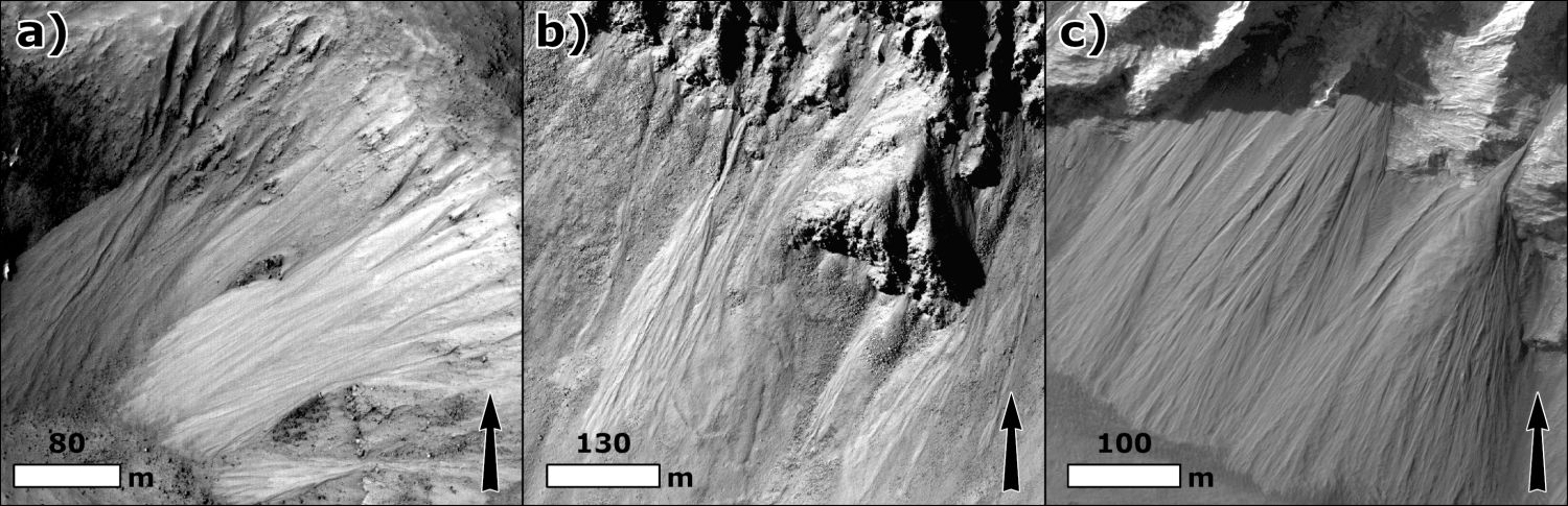
Figure 1: HiRISE examples of equatorial gullies: a) ESP_036987_1825, b) ESP_036209_1720, c) ESP_088659_1715.
Approach
We inspect available HiRISE images between 25°S and 25°N containing sloping terrain - identified from a MOLA slope map filtered to terrain exceeding 9° within the HiRISE footprint. Gullies were identified by searching for narrow, elongated, leveed downslope channels with variable alcove and apron development. Each image was tagged, “yes”, “no”, “maybe” or “unusable”. To test spatial clustering while accounting for the non-random distribution of HiRISE images, we performed a hotspot analysis based on Viola and McEwen [9].
A subset of the gully sites underwent additional morphological analysis, noting: gully orientation (average azimuth of the gully centreline), alcove depth (“deep”, “intermediate” or “shallow”), bedrock coverage (“low”, “intermediate” or “high”) and morphological expression (“well-developed”, “moderate” or “poor”).
Finally, we examined digital terrain models (DTMs) derived from stereo pairs of HiRISE images at 1-2 m/pix, sourced from the Planetary Data System, generated by MarsSI (https://marssi.univ-lyon1.fr/) using the Ames Stereo Pipeline [10], or using the ISIS-SocetSet workflow [11]. We extracted the average slope from profiles along the gullied zone, from the slope below the termination and from non-gullied slopes in similar settings.
Results and discussion
We inspected 1558 HiRISE images between 25°S and 25°N and found 288 containing equatorial gullies (Figure 2). Clustering analysis identifies statistically significant concentrations in southern Erebus Montes, the chaos terrains east of Valles Marineris and the zone spanning from southern Isidis to eastern Hellas, with significant absences in the broad Tharsis Rise region and in Terra Sabea. We found no convincing correlation with dust cover index, thermal inertia, or elevation - such variables should influence their distribution if volatiles were involved [12,13].
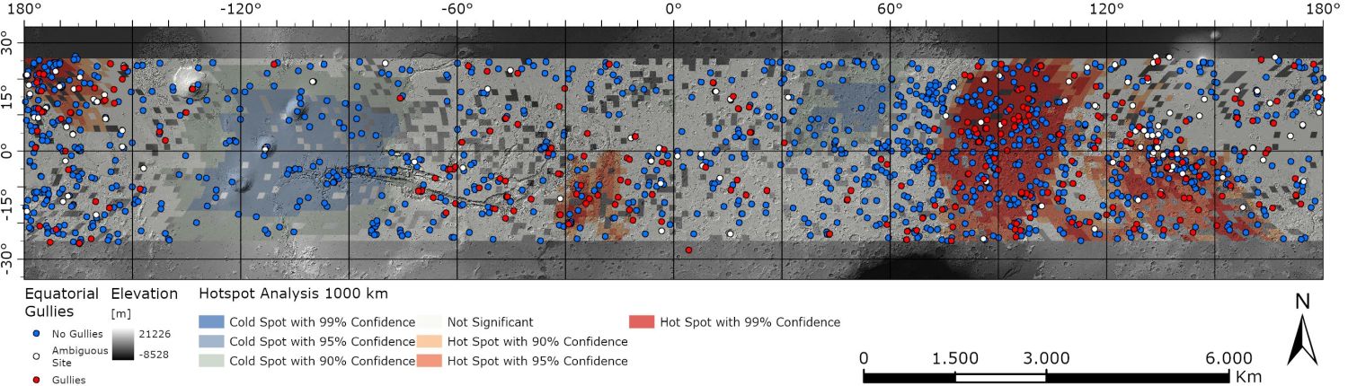
Figure 2: Distribution of equatorial gully sites (25°S-25°N) overlaid on a MOLA shaded relief and results from the hotspot analysis (fixed distance band of 1000 km).
Detailed morphological analysis on 89 sites (481 gully fields), revealed no obvious trend in orientation with latitude, such as that found in mid-latitude gullies [14] caused by CO2 sublimation or in rockfalls caused by thermal stress [15]. However, these features may represent the integration of a process occurring over a wide range of orbital conditions that could obscure any obvious latitudinal trend.
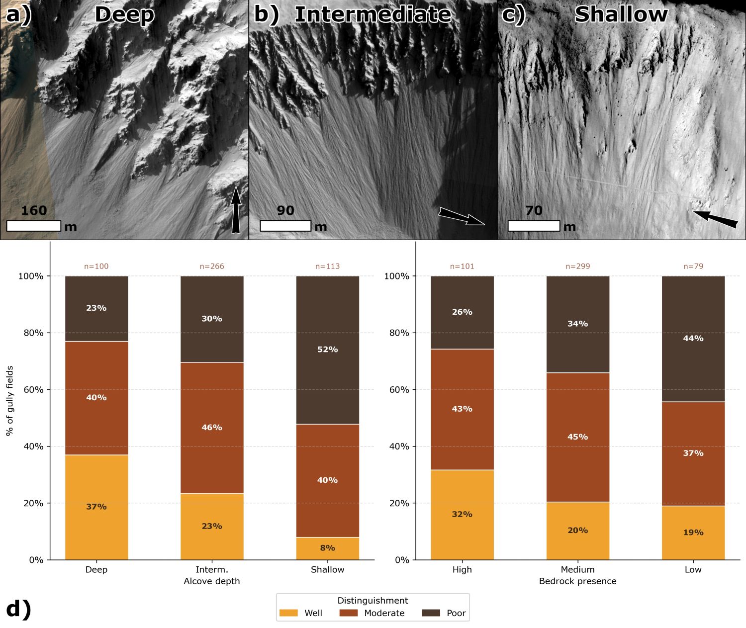
Figure 3: Morphological expression of equatorial gullies by alcove depth and bedrock presence. HiRISE images of a) deep (ESP_087891_1565), b) intermediate (ESP_088507_1720), and c) shallow (ESP_088930_1735) alcoves. d) Stacked bar charts showing the proportion of gully fields as a function of alcove depth (left) and bedrock presence (right).
Gullies are more numerous in sites where the bedrock has well-developed alcoves (Figure 3). Analysis of 36 DTMs covering 243 equatorial gullies, 126 adjacent slopes and 137 non-gullied slopes shows that equatorial gullies erode and deposit on slopes of 29.7-39.8°, statistically steeper than non-gullied slopes (Figure 4). This clearly sets equatorial gullies apart from mid-latitude gullies, supporting the assumption made in previous studies.
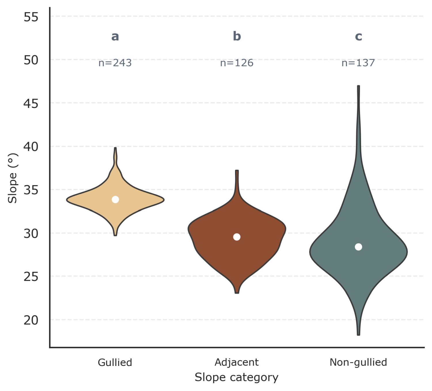
Figure 4: Slope angle distributions (°) for (a) gullied, (b) adjacent and (c) non-gullied slopes.
Conclusions
- We present the first systematic catalogue of 288 sites with equatorial gullies on Mars
- Equatorial gullies show regional clusters of high and low density, which cannot be linked to variation in surface dust cover, thermal inertia or elevation. Equally no systematic orientation trends are observed with latitude. We would expect the opposite to be the case if volatiles were involved in the process.
- We find that equatorial gullies are best developed below deep bedrock alcoves and deposit on slopes generally >29°, setting them apart from mid-latitude gullies.
References cited: [1] T.N. Harrison et al. (2015) Icarus, 252, 236–254. [2] A. Noblet et al. (2024) Icarus, 418, 116147. [3] M.C. Malin and K.S. Edgett (2000) Science, 288, 2330–2335. [4] J.L. Heldmann et al. (2005) JGR, 110. [5] C.M. Dundas et al. (2019) GSL, 467. [6] L. Roelofs et al. (2024) Commun. Earth Environ., 5, 125. [7] K.C. Auld and J.C. Dixon (2016) PSS, 131, 88–101. [8] M.F. Thomas et al. (2020) Icarus, 342, 113566. [9] D. Viola and A.S. McEwen (2018) JGR, 123, 262–277. [10] R.A. Beyer et al. (2018) Earth Space Sci., 5, 537–548. [11] S.S. Sutton et al. (2022) Remote Sens., 14, 2403. [12] L. Lange et al. (2023) GRL, 50, e2023GL105177. [13] S. Piqueux et al. (2016) JGR, 121, 1174-1189. [14] S.J. Conway et al. (2019) GSL, 467. [15] P.-A. Tesson et al. (2020) Icarus, 342, 113503.
How to cite: van Elswijk, L., Roelofs, L., and Conway, S.: Mapping Equatorial Gullies on Mars, Europlanet Science Congress 2026, The Hague, The Netherlands, 6–11 Sep 2026, EPSC2026-801, https://doi.org/10.5194/epsc2026-801, 2026.


