
 1,1,
1,1,- 1International Research School of Planetary Sciences, Università “G. d’Annunzio”, Pescara, Italy (francesca.mancini@unich.it)
- 2Université Claude Bernard Lyon 1 LGL-TPE France
- 3Ibn Battuta Centre, Université Cadi Ayyad, Boulevard Abdelkrim Al Khattabi, Marrakech, Morocco
Arabia Terra is one of the oldest and most geologically complex regions of Mars, forming a broad transition zone between the ancient southern highlands and the northern lowland plains. The region hosts widespread layered deposits, erosional remnants, intracrater mounds, fretted valleys, isolated mesas and possible volcanic or volcaniclastic units [1]. Layered deposits have been interpreted as the result of sedimentary accumulation, airfall deposition, groundwater-related processes, erosion and possible volcanic activity [2–5] and are regarded as remnants of a formerly more extensive sedimentary cover locally associated with sulfate-bearing and Meridiani-type materials [6–9].
Within this context, Flat-Topped Mountains (FTMs) represent a distinctive but poorly characterized class of positive-relief landforms in Arabia Terra. They are defined here as isolated or semi-isolated reliefs with broad, sub-planar summit surfaces, well-defined basal margins and variably degraded flanks. The term FTM is used as a descriptive geomorphic category, deliberately neutral with respect to origin, to assess their possible affinities with erosional mesas, layered mounds, exhumed landforms, groundwater-related deposits and volcanic or volcaniclastic edifices.
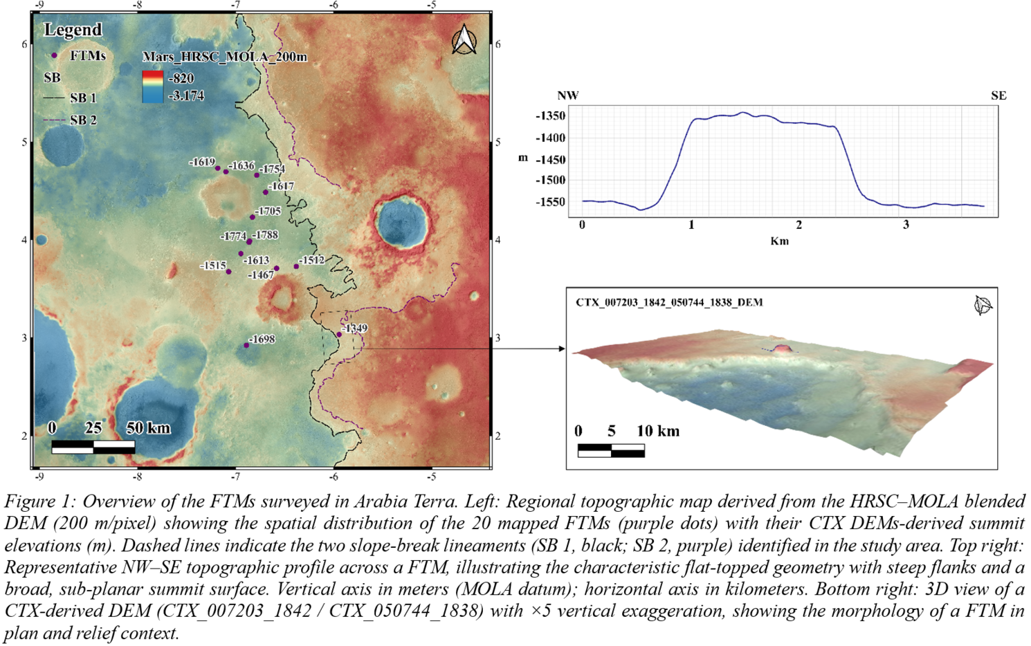
We conducted a systematic survey of FTMs using a multi-dataset approach, integrating Context Camera (CTX) mosaics from the Murray Lab [10,11], three CTX-derived digital elevation models (DEMs) generated with the Ames Stereo Pipeline (ASP) and ISIS [12,13] and Mars Orbiter Laser Altimeter (MOLA) data [14]. A total of 20 FTMs were identified and mapped. For each landform, we extracted total height (H), basal diameter (DB) and summit diameter (DS), absolute summit elevation (Z) and computed DS/DB as a first-order morphometric proxy for assessing affinities with erosional remnants or constructional edifices [15].
The 13 mapped FTMs (Fig. 1) exhibit H values ranging from ~80 to ~309 m, DB from ~0.49 to ~2.66 km and Ds from ~0.23 to ~1.42 km. DS/DB ratios range from ~0.43 to ~0.78, indicating variable degrees of summit preservation and flank retreat. CTX DEMs-derived summit elevations range from approximately −1788 to −1349 m (mean ~−1619 m, standard deviation ~126 m). The broad interquartile range (~265 m) confirms that FTM summit surfaces do not define a single, regionally continuous elevation level. Summit elevations broadly follow the regional topographic gradient and several FTMs occur close to lineaments of abrupt topographic gradient change, hereafter referred to as slope breaks (SBs). The partial correspondence between FTM summit elevations and SBs may indicate local control by pre-existing topography, differential erosion or stratigraphic discontinuities.
Three non-mutually exclusive formation scenarios are considered. First, FTMs may represent erosional remnants of formerly more extensive sedimentary or volcaniclastic sequences, shaped by differential erosion and possibly capped by more resistant material; although internal layering is not directly resolved at CTX resolution in the present dataset, this scenario is consistent with the regional stratigraphy of Arabia Terra [2,5,7–9,16,17]. Second, some FTMs may record groundwater-related deposition, fluid expulsion or consolidation processes later exposed by erosion, in agreement with models of prolonged hydrogeological activity in the region [6,9,18]. Third, a volcanic or volcaniclastic origin cannot be excluded, given the proposed ancient volcanic province of Arabia Terra [4]; more speculatively, some morphologies could be compared with tuya-like edifices formed by lava–ice interaction [15,19–21,22]. The absence of diagnostic volcanic textures in the present dataset, however, suggests that this interpretation should remain a working hypothesis. Separately, the broad range of summit elevations argues against truncation at a single regional water level, as would be expected for a simple wave-planation origin.
The TIN interpolation of CTX DEM-derived summit elevations provides an exploratory view of the spatial distribution of FTM summit heights. The resulting pattern suggests that summit elevations are not randomly distributed, but may define distinct altimetric domains or a broad regional trend, with summit levels broadly grouped around −1780/−1750 m, −1650/−1600 m and locally up to −1350 m. If confirmed, this arrangement could record distinct paleolake or paleoshoreline levels, an interpretation consistent with paleohydrological models for Arabia Terra [6,9] and not necessarily excluded by the association with SBs.
This preliminary morphometric and topographic census provides a first quantitative description of FTMs in Arabia Terra and highlights their potential value as geomorphic markers of depositional, erosional, hydrological and possibly volcanic processes. FTMs likely do not represent a single genetic class, but a morphologically coherent population shaped by different combinations of deposition, induration, erosion and exhumation. Future work will integrate crater-retention ages, stratigraphic analysis and high-resolution image interpretation to discriminate between formation scenarios and assess their implications for the geological evolution of Arabia Terra during the Noachian–Hesperian transition.
References
[1] Tanaka, K.L., et al. (2014). USGS SIM 3292. [2] Fassett, C.I. and Head, J.W. (2007). JGR: Planets, 112, E08002. [3] Fergason, R.L. and Christensen, P.R. (2008). JGR: Planets, 113, E12001. [4] Michalski, J.R. and Bleacher, J.E. (2013). Nature, 502, 47–52. [5] Pondrelli, M., et al. (2015). GSA Bulletin, 127, 1064–1089. [6] Andrews-Hanna, J.C., et al. (2010). JGR: Planets, 115, E06002. [7] Zabrusky, K., et al. (2012). Icarus, 220, 311–330. [8] Annex, A.M. and Lewis, K.W. (2020). JGR: Planets, 125, e2019JE006188. [9] Schmidt, G., et al. (2021). JGR: Planets, 126, e2021JE006974. [10] Malin, M.C., et al. (2007). JGR: Planets, 112, E05S04. [11] Dickson, J.L., et al. (2024). Earth and Space Science, 11, e2024EA003555. [12] Beyer, R.A., et al. (2018). Earth and Space Science, 5, 537–548. [13] Paquette, A.C. (2023). USGS data release, doi:10.5066/P1374ZGR. [14] Smith, D.E., et al. (1999). Science, 284, 1495–1503. [15] Ghatan, G.J. and Head, J.W. (2002). JGR: Planets, 107, 5048. [16] Edgett, K.S. (2005). The Mars Journal, 1, 5–58. [17] Davis, J.M., et al. (2019). JGR: Planets, 124, 1913–1934. [18] Di Pietro, I., et al. (2023). JGR: Planets, 128, e2022JE007504. [19] Smellie, J.L. and Skilling, I.P. (1994). Sedimentary Geology, 91, 115–132. [20] Chapman, M.G. and Tanaka, K.L. (2001). JGR: Planets, 106, 10087–10100. [21] Ackiss, S.E., et al. (2018). Icarus, 311, 357–370. [22] Komatsu, G., et al. (2007). Geomorphology, 88, 352–366.
How to cite: Mancini, F., Mariani, E., Pondrelli, M., Allemand, P., and Ori, G. G.: Flat-Topped Mountains in Arabia Terra, Mars: Morphometric Characterization and Genetic Implications, Europlanet Science Congress 2026, The Hague, The Netherlands, 7–11 Sep 2026, EPSC2026-822, https://doi.org/10.5194/epsc2026-822, 2026.


