
 1,2,1,1,1
- 1INAF - IAPS, Rome, Italy
- 2Politecnico di Milano, Milan, Italy
Introduction
Ma_MISS is the visible and near-infrared spectrometer embedded in the drill system of the ExoMars Rosalind Franklin rover [1]. It will acquire spectral reflectance measurements along the walls of boreholes drilled into the Martian subsurface, down to depths of about 2 m, providing mineralogical and stratigraphic information in situ before samples are extracted and delivered to the rover analytical laboratory. Ma_MISS acquires single-point spectra through a small sapphire window on the side of the drill tool. Each spectrum is collected from a small spot (about 120 μm large) on the borehole wall. By exploiting the finely controllable rotation and vertical translation of the drill tool, Ma_MISS can build hyperspectral maps of the borehole wall, acquiring one spatial pixel at a time. A sequence of acquisitions interleaved with small drill rotations produces a “ring” scan, while a “column” operation consists of multiple rings acquired at different depths, with small vertical translations between consecutive rings.
Operations simulation and planning
The scientific return of Ma_MISS observations will depend strongly on the selected acquisition strategy. A Ma_MISS operation is defined mainly by the angular step between acquisitions, the vertical step between rings, the number of points per ring, and the number of rings. These parameters control the spatial sampling and the depth interval covered by a scan, but they also determine the time, data volume, and energy required to complete the operation. Since the time available for Ma_MISS observations during rover operations will be limited, operation planning requires explicit trade-offs between spatial resolution, depth coverage, and resource constraints.
We are developing software tools to support the planning and optimization of Ma_MISS acquisition sequences. The first component is a command-sequence simulator that estimates the duration and generated data volume from a proposed sequence of Ma_MISS commands. These estimates can be used in two complementary planning modes. In the first, the user fixes the spatial sampling and resource limits, and the tool determines the maximum depth interval that can be covered within the available time. In the second, the user specifies the depth interval to investigate and the available resources, and the tool searches for an acquisition strategy that maximizes the expected scientific return. This second approach is essentially a constrained optimization problem and requires a quantitative objective function. Importantly, the best strategy is not necessarily the one with the largest number of individual spectra: depending on the target material and on the scientific objective, a more regular sampling pattern, or a different balance between angular and vertical resolution, may preserve more useful information.
Simulations based on DAVIS measurements
To develop and test optimization strategies and to compare acquisition sequences meaningfully, it is necessary to simulate not only the required resources but also the hyperspectral datasets that would be produced by different Ma_MISS acquisition sequences. Previous work used synthetic borehole geometry models to rapidly generate simulated datasets [2]. Here we extend this approach using DAVIS, a Ma_MISS laboratory model designed to acquire spectra inside holes drilled in rock samples, with a measurement geometry and optical head representative of Ma_MISS [3]. Through automated rotation and translation actuators, DAVIS can be used to reproduce Ma_MISS acquisition sequences in rock samples.
As a first proof of concept, we acquired a high-spatial-sampling DAVIS scan over a limited region inside the hole of a drilled rock sample. The scan covered an angular sector of about 9° and a depth range of about 40 mm, using a rotation step of 0.5° and a vertical step of 0.1 mm. The resulting dataset contains 7200 spectra, arranged as 400 partial rings of 18 points each. Coarser acquisition strategies can then be simulated by subsampling this reference dataset. Figure 1 shows examples of such strategies, from the full 18 × 400 acquisitions dataset to progressively faster operations with fewer acquired points.
To compare the simulated strategies, each subsampled dataset was interpolated back onto the full grid using bilinear interpolation (Figure 2). The interpolated products can then be compared with the complete high-resolution dataset to quantify the information lost when the number of acquisitions is reduced. As an example metric, we used the Structural Similarity Index (SSIM) [4] to rank acquisition strategies according to their similarity to the full reference dataset. This provides a practical demonstration of how laboratory hyperspectral data can be used to define objective functions for Ma_MISS operation planning.
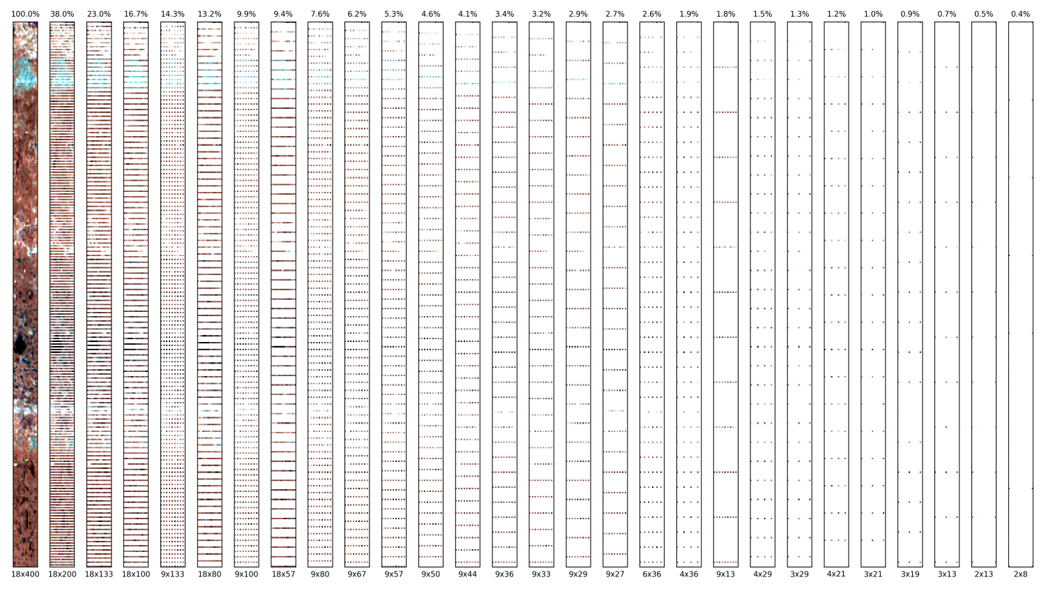
Figure 1. Each panel shows the results of a different acquisition strategy simulated from DAVIS data, with operation decreasing duration from left to right. The leftmost panel shows the full dataset. The hyperspectral dataset is represented as an RGB composite of three bands (660 nm, 532 nm, 480 nm respectively). The duration of each sequence is reported above each panel as a percentage of the duration of the full sequence.
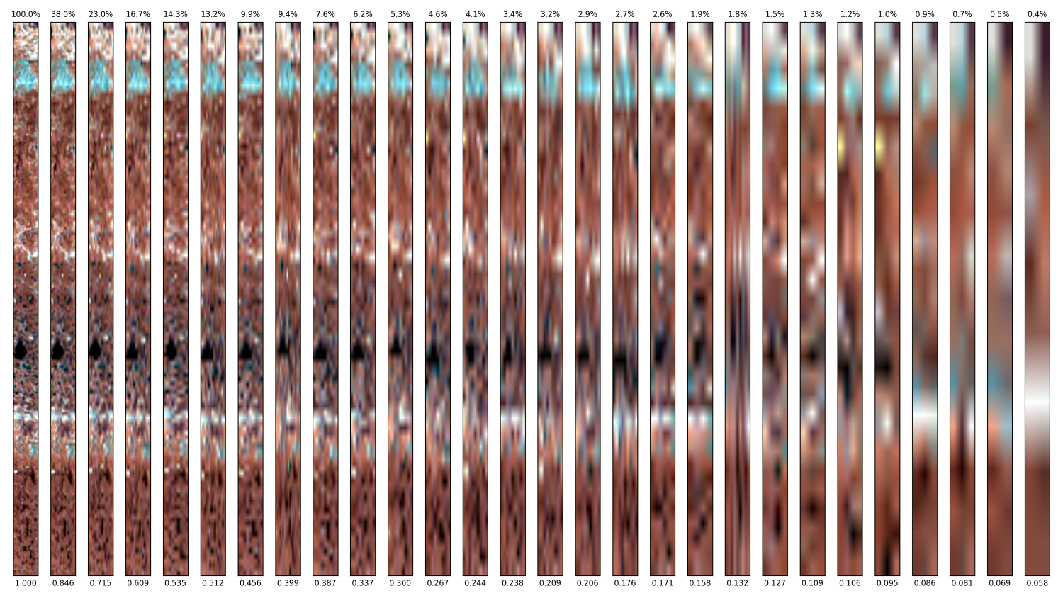
Figure 2. Same as Figure 1, but with each simulated hyperspectral dataset interpolated back to the original size. The SSIM value is reported below each panel.
Future work
This preliminary test is based on a small spatial region and on a single, highly heterogeneous rock sample. Future work will extend the method by using DAVIS to simulate more complete Ma_MISS scans, including acquisitions over the full borehole circumference and larger depth intervals. We will also test multiple rock samples with different textures and degrees of heterogeneity, including layered, clastic, and veined materials. This will allow us to evaluate how the optimal Ma_MISS acquisition strategy depends on the geological target and to develop more robust metrics for quantifying scientific return and comparing different acquisition strategies.
Acknowledgements
This work is supported by the ASI grant ASI-INAF n. 2023-3-HH.0 and by the ESA Rosalind Franklin Mission’s Ma_MISS SKP (Science Knowledge Programme).
References
[1] De Sanctis M. C. et al. (2022), Planetary Science Journal, 3, 142. https://doi.org/10.3847/PSJ/ac694f
[2] Rossi L. et al. (2022), EPSC2022-391. https://doi.org/10.5194/epsc2022-391
[3] De Angelis S. et al. (2022), LPSC 53, Abstract #1796.
[4] Wang Z. et al. (2004), IEEE Transactions on Image Processing, 13, 600–612. https://doi.org/10.1109/TIP.2003.819861
How to cite: Rossi, L., Fonte, S., Bruschini, E., Jimenez Sanz, D., De Angelis, S., Altieri, F., and De Sanctis, M. C.: Simulating and optimizing Ma_MISS operations, Europlanet Science Congress 2026, The Hague, The Netherlands, 7–11 Sep 2026, EPSC2026-846, https://doi.org/10.5194/epsc2026-846, 2026.


