
 1,4,3,3,3,1
- 1Imperial College London, Earth Science and Engineering, United Kingdom (nid20@ic.ac.uk)
- 2Royal Holloway University of London, United Kingdom
- 3German Aerospace Center (DLR), Microwaves and Radar Institute, Germany
- 4isardSAT, Spain
In preparation for the Envision mission to Venus, multi-frequency airborne Synthetic Aperture Radar (SAR) data collected in August 2023 over Iceland, by the DLR for NASA JPL and the VERITAS mission team (using the F-SAR system) [2-5], has been analysed across a series of basaltic lava flows of differing ages. Fieldwork in July-August 2026 in the Reykjanes Peninsula has provided some vital ground-truth (surface roughness and very high-resolution topography) for our analysis. Our investigations are aimed at better understanding the scales and scattering characteristics of young basaltic volcanic landscapes, and SAR data-processing algorithms applied to volcanic terrain data.
Analysis of the 2023 F-SAR data at Askja enabled characterisation of seven lava flow units from 1961 (Vikrahraun) to >6100 yr BP using the full-polarimetric X-, S-, and L-band SAR with paired pin-profilometer and drone Digital Elevation Model (DEM) data (Figure 1). Across the Askja flow sequence, mean backscatter decreases systematically with flow age, and decomposition techniques partitions the flows sequence by facies. We now extend this framework to the Reykjanes Peninsula. 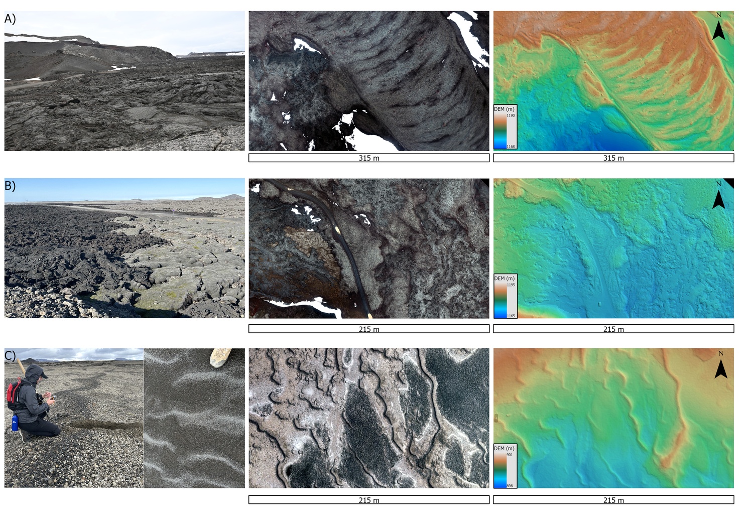
Figure 1. Representative surface units. Left: field photos; centre: drone orthomosaics; right: drone-derived DEMs. (A) Inflated pāhoehoe with pressure ridges; (B) a'ā-pāhoehoe contact; (C) tephra plain with aeolian bedforms. Horizontal scale bars and DEM elevation ranges (m a.s.l.) shown per row.
Complementary analysis of field data across the fresher flows at the Reykjanes Peninsula enables bare-versus-mantled backscatter comparison of several flow units because of the occurrence of moss/lichen colonisation in a slightly warmer climate (Figure 2). Five age groups have been sampled: the Sundhnúkur-Svartsengi system, with nine flows emplaced between December 2023 to August 2025 along a c. 10 km fissure north of Grindavík (fieldwork ages 1-2.5 yr [6]); the Fagradalsfjall system comprising the 2021 Geldingadalir flow (5 yr [7]); the Skollahraun and younger Afstapahraun lavas (c. 2000 yr [8]); the Litla Eldborg flow field (>4000 yr [8]); and the Þráinsskjöldur shield (c. 12,500-14,100 yr [8]). The older three groups carry progressively thicker moss and lichen coverage. This combination delivers a bare versus mantled comparison at matched ages within a single field area at near-uniform basaltic composition, and supports lava-flow facies analysis within each flow field. 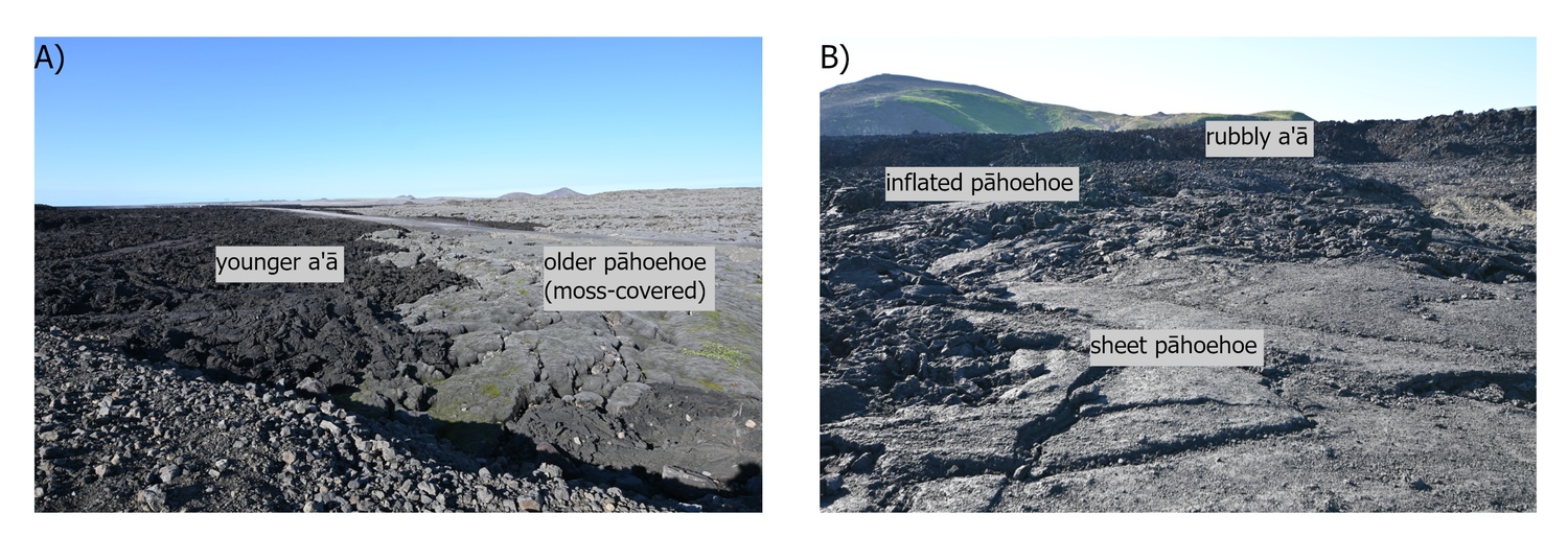
Figure 2 Field morphology and flow-age contrasts. (A) Direct contact between younger a'ā and older moss-covered pāhoehoe; foreground field of view c.3 m. (B) Examples of morphological end-members: rubbly a'ā, inflated pāhoehoe, and sheet pāhoehoe; foreground field of view c.2 m.
Our 2026 field investigations yielded a series of important datasets: facies maps of the Sundhnúkur sequence at 1:5000 scale (classifying pāhoehoe, rubbly pāhoehoe, slabby/platy, spiny, and ʻaʻā facies on selected flows); pin-profilometer surface roughness measurements across the Reykjanes flows (distributed by facies, age, and surface-cover) (Figure 3), and drone-derived DEMs spanning the different facies and ages for scaling roughness statistics up to the scale of the spatial resolution of the F-SAR data (2 m). Together, these measurements deliver fine-scale topography (slopes at cm, dm, and m scales) linking millimetre-scale surface roughness to SAR backscatter at S- and X-band, and enable the quantification of fine-scale morphology (channels, breakouts, tumuli, rubble margins) for direct correlation with radar backscatter. Combined with the existing Askja results, these datasets deliver age sequences of basaltic lava flows with bare and mantled patches, co-located ground-truth from mm to m scale, all tied to multi-frequency polarimetric F-SAR data.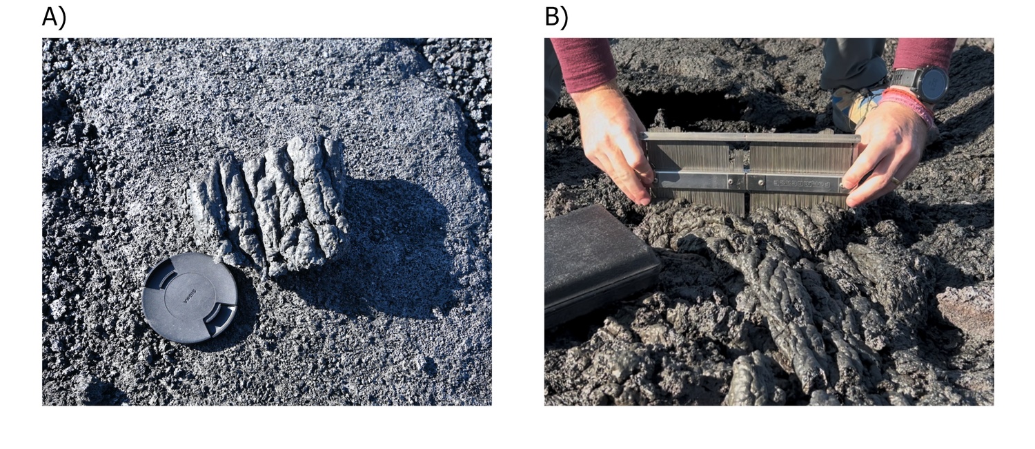
Figure 3 Ground-truth surface roughness characterisation. (A) Ropy pāhoehoe close-up with lens cap (c.7 cm diameter) for scale. (B) Penn Industries M5-S pin profilometer (1 mm pin spacing) capturing a transverse profile across pāhoehoe ropes.
The combined F-SAR and field dataset has supported four types of analysis: (i) comparison of Mascolo dual-pol [9] and Freeman-Durden quad-pol [10] decompositions across the facies and age, across Askja and Reykjanes flow sequences; (2) Comparison of bare and mantled flows to test penetration by long wavelengths through dry mantling materials into lava-roughness scattering; (3) integrated analysis of multi-temporal airborne F-SAR scenes and with; and (iv) progressive degradation of F-SAR products from 2 m to 10 m, 30 m to simulate VenSAR imagery and evaluate the effect of spatial resolution on scattering characteristics.
Venus is a barren basaltic landscape where surface modification is driven by chemical weathering and cementation from basalt–atmosphere interactions at 460°C and 92 bar [11], rather than by the rapid aeolian and biological processes that dominate Earth's basaltic surfaces. These reactions progressively modify surface texture and dielectric properties relevant to radar scattering. This terrestrial analogue work cannot directly emulate Venusian weathering, but it can rigorously partition modification mechanisms on Earth and demonstrate systematic backscatter patterns across them.
The analysis yields a multi-frequency polarimetric scattering library resolved by flow age and facies at the VenSAR pixel scale, with bare-versus-mantled comparisons of flows of various ages, and a quad-pol versus dual-pol decomposition comparison tuned to VenSAR’s HH+HV configuration. In addition, a quantitative framework is built which links mm- and cm- scale topography to m- and dm- scale backscatter, slopes, and polarimetric signatures over basaltic volcanic landscapes, supporting sub-pixel detection of surface properties.
References. [1] EnVision Red Book, ESA-SCI-DIR-RP-003. [2] Keller et al., EUSAR 2024. [3] Hensley et al., LPSC 2024 #1137. [4] Mastrogiuseppe et al., LPSC 2024 #1447. [5] Nunes et al., LPSC 2024 #1681. [6] Pinter et al., Nat Hazards 2026. [7] Pedersen et al., GRL 2022. [8] Sæmundsson et al., Jarðfræðikort af Suðvesturlandi 1:100,000 (2nd ed.), Íslenskar orkurannsóknir, 2016. [9] Mascolo et al., IEEE TGRS 2021. [10] Freeman & Durden, IEEE TGRS 1998. [11] Filiberto et al., Sci Adv 2020.
How to cite: Davidova, N., Gallardo i Peres, G., Gao, Y., Awasthi, S., Ghail, R., Moreira, A., Jaeger, M., Benedikter, A., and Mason, P.: Multi-scale surface characterisation of recently erupted lava flows on the Reykjanes Peninsula: a 2026 field campaign in support of EnVision mission science development, Europlanet Science Congress 2026, The Hague, The Netherlands, 7–11 Sep 2026, EPSC2026-858, https://doi.org/10.5194/epsc2026-858, 2026.


