
 1,2,4,
- 1University of Gothenburg, Department of Earth Science, Gothenbrug, Sweden (cynthia.sassenroth@gu.se)
- 2German Aerospace Center (DLR), Institute of Planetary Research, Berlin, Germany
- 3German Aerospace Center (DLR), Institute of Optical Sensor Systems, Berlin, Germany
- 4Technical University of Munich (TUM), Chair of Landslide Research, Munich, Germany
- 5University of Nantes, Laboratoire de Planétologie et Géosciences (LPG), Nantes, France
- 6University of Washington, Department of Earth and Space Science, Seattle, USA
- 7National Aeronautics and Space Administration (NASA), NASA Marshall Space Flight Center/ST13, Huntsville, USA
- 8Norwegian Water Resources and Energy Directorate (NVE), Oslo, Norway
- 9University of Münster, Institute for Planetology, Münster, Germany
Understanding landforms and quantifying rates of surface change in cold-climate regions remain some of the key challenges in interpreting ice-related landforms on Mars. Polygonised terrains, lobate debris aprons, gullies, viscous flow features, and ice-rich mantling deposits observed across the Martian mid-latitudes are commonly interpreted as evidence for near-surface ice, glacial activity, freeze-thaw processes, and potentially liquid water [1-8]. However, many Martian landforms remain difficult to interpret because similar morphologies may form through different processes [9]. Terrestrial analogue studies are therefore essential for constraining process-form relationships, quantifying rates of landscape evolution, and identifying geomorphological signatures diagnostic of ice- and water-related surface processes [10].
The rapidly evolving permafrost landscapes of western Svalbard are very instructive natural laboratories for investigating cold-climate geomorphological processes relevant to Martian mid-latitude terrains [6,11,15]. Within the framework of the Svalbard Permafrost Landforms as Analogues for Mars (SPLAM) initiative, repeated airborne and field-based investigations have been conducted since 2008 in the Ny-Ålesund region, including Kvadehuksletta, the Kongsfjorden lateral moraine systems, and recently deglaciated forefields such as Engelsbukta [11-13]. These investigations build upon pioneering long-term periglacial monitoring studies initiated during the 1980s at Kvadehuksletta and surrounding areas [12] and are complemented by long-term atmospheric and permafrost monitoring sites in the Ny-Ålesund region [18]. Together, these datasets provide a rare opportunity to investigate geomorphological and permafrost dynamics across seasonal to multi-decadal timescales. The monitored environments serve as terrestrial analogues for polygonised terrains, latitude-dependent mantle deposits, lobate debris aprons, viscous flow features, and gully-associated landforms observed on Mars.
SPLAM has established a >15-year multi-temporal geomorphic monitoring record integrating photogrammetry (Fig. 1), airborne and mobile LiDAR surveys [14], geomorphological mapping, ground-penetrating radar (GPR) [17], electrical resistivity tomography (ERT), and repeat sedimentological and permafrost field investigations. Remote sensing imagery acquired RGB, near-infrared, and thermal datasets used to generate centimeter-scale orthomosaics and Digital Surface Models (DSMs; Fig. 1). All datasets are geodetically constrained using differential Global Navigation Satellite System (dGNSS) measurements with cm-scale accuracy. Multi-temporal DSM differencing and morphometric analyses were generated to quantify cm-scale surface changes since 2008 [14,15].
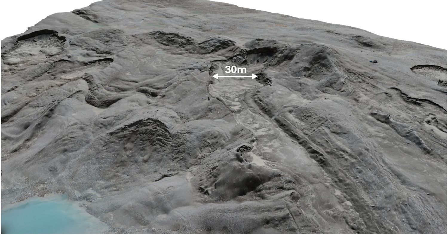
Figure 1: Ultra-high-resolution (cm-scale) Digital Surface Model (DSM) of the ice-cored lateral moraine system at Kongsfjorden, western Svalbard. The moraine is characterized by active debris-flows, rapid surface changes, and widespread thermokarst degradation associated with ice melt. The retrogressive degradation of the scarp reaches several meters per week. The DSM was generated from stereo-imagery acquired using a kite-based camera system, operating approximately 30 m above ground, and structure-from-motion photogrammetry (image credit: N. Schmedemann, 2026).
Subsurface investigations play a central role in the SPLAM framework and aim to link remotely observable surface features with subsurface characteristics such as active layer thickness, permafrost table depth, soil grain-size distribution, mineralogical composition, moisture conditions, and temperature. GPR surveys are used to characterize shallow subsurface architecture, buried ice bodies, and internal moraine structure. ERT and electromagnetic resistivity measurements provide complementary constraints on subsurface ice distribution, saline permafrost occurrence [13], sediment moisture conditions, and freeze-thaw dynamics. The integration of geophysical and remote sensing datasets enables direct comparison between surface morphology and subsurface permafrost conditions.
Current work focuses on quantifying surface changes and the rates at which they occur in diverse terrain that includes degrading ice-cored moraines, thermokarst development, active layer dynamics, cryopeg occurrence, active patterned ground (Fig. 2), and paraglacial adjustment following glacier retreat. By integrating long-term remote sensing, geophysical, and field datasets, SPLAM investigates how rapidly evolving Arctic permafrost systems respond to environmental change, and how these processes can improve interpretations of Martian periglacial environments relevant for future planetary exploration and in-situ resource utilization (ISRU) [4,16].
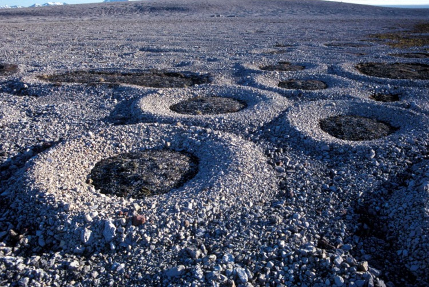
Figure 2: Active sorted circles in Kvadehuksletta, Svalbard. These circles, meters in diameter within gravel ridges up to 0.3 m high, are among the best developed worldwide and they coexist with other patterned ground features, including sorted stripes, sorted nets, and thermal contraction polygons (image credit: B. Hallet, 1988).
References
[1] Plaut et al. (2009) GRL 36, L02203. https://doi.org/10.1029/2008GL036379 [2] Dundas et al. (2018) Science 359, 199-201. https://doi.org/10.1126/science.aao1619 [3] Warren et al. (2024) Planetary Science Journal 5, 174. https://doi.org/10.3847/PSJ/ad5e6f [4] Sako et al. (2025) JGR Planets 130, e2023JE008232. https://doi.org/10.1029/2023JE008232 [5] Malin & Edgett (2000) Science 288, 2330-2335. https://doi.org/10.1126/science.288.5475.2330 [6] Hauber et al. (2011) Geological Society Special Publication 356, 111-131. https://doi.org/10.1144/SP356.7 [7] Gallagher et al. (2011) Icarus 211, 458-471. https://doi.org/10.1016/j.icarus.2010.09.010 [8] Dickson et al. (2023) Science 380, 1363-1367. https://doi.org/10.1126/science.abk2464 [9] Hallet et al. (2022) JGR Planets 127, e2021JE007126. https://doi.org/10.1029/2021JE007126 [10] Baker (2014) Planetary and Space Science 95, 5-10. https://doi.org/10.1016/j.pss.2012.10.008 [11] Sassenroth et al. (2023) Geografia Fisica e Dinamica Quaternaria 46, 135-151. https://doi.org/10.4454/23dce671 [12] Hallet, B., 2013. Stone circles: form and soil kinematics. Phil. Trans. Royal Soc. A: Math, Phys. and Eng. Sci, 371 (2004) https://doi.org/10.1098/rsta.2012.0357. [13] Angelopoulos et al. (2025) EGU25-19953. https://doi.org/10.5194/egusphere-egu25-19953 [14] Zanetti et al. (2025) LPSC 56, #2124 [15] Hauber et al. (2025) EPSC-DPS2025-1794. https://doi.org/10.5194/epsc-dps2025-1794 [16] Morgan et al. (2025) Planetary Science Journal 6, 29. https://doi.org/10.3847/PSJ/ad9b24 [17] Johantges et al. (2024) LPSC 55, #2611 [18] Boike et al. (2018) Earth System Science Data 10, 355-390. https://doi.org/10.5194/essd-10-355-2018
How to cite: Sassenroth, C., Johnsson, A., Hauber, E., Bucher, T., Angelopoulos, M., Berquez, S., Hallet, B., Zanetti, M., Berthling, I., Schmedemann, N., and Hiesinger, H.: Svalbard Permafrost Landforms as Analogues for Mars (SPLAM): Long-Term Monitoring of Permafrost Dynamics and Water-Related Surface Processes , Europlanet Science Congress 2026, The Hague, The Netherlands, 6–11 Sep 2026, EPSC2026-911, https://doi.org/10.5194/epsc2026-911, 2026.


