EPSC Abstracts
Vol. 19, EPSC2026-938, 2026, updated on 14 Sep 2026
https://doi.org/10.5194/epsc2026-938
Europlanet Science Congress 2026
© Author(s) 2026. This work is distributed under the Creative Commons Attribution 4.0 License.

Buried Ice Degradation and Rapid Proglacial Landscape Evolution in Svalbard: Implications for Martian Cold-Climate Geomorphology
 1,2,3,4,,
- 1Nantes Université, Nantes, France
- 2Department of Earth Sciences, University of Gothenburg, Gothenburg, Sweden
- 3Technical University of Munich (TUM), Munich, Germany
- 4German Aerospace Center (DLR), Institute of Planetary Research, Berlin, Germany
- 5Department of Earth and Space Sciences, University of Washington, Seattle, WA, USA
- 6Institute of Planetology, University of Münster, Münster, Germany
- 7NASA, Moffett Field, CA, USA
Introduction
Artic proglacial systems represent valuable terrestrial analogues for Martian cold-climate environments (Hauber et al., 2011), as they allow observation of processes responsible forming cold-climate landforms on Mars. In particular, the presence and distribution of ground ice on Mars are of major scientific interest, to understand its past hydrology, evaluate potentially habitable environments, and identify water resources for future exploration and in situ resource utilization (ISRU).
In Svalbard, the glacier retreat and buried ice degradation produce dynamic landscapes, evolving at human timescales, generating collapse features (Hibbard et al., 2025), reorganizing hydrological systems, and reshaping sedimentary structures (Kavan et al., 2024). Studying these environments and linking them to ground ice and permafrost dynamics provides insights into the formation and preservation of cold-climate landforms potentially comparable to Martian surface textures and collapse patterns, which may represent frozen snapshots of past glacial and hydrological activity.
In Svalbard, the glacier retreat and buried ice degradation produce dynamic landscapes, evolving at human timescales, generating collapse features (Hibbard et al., 2025), reorganizing hydrological systems, and reshaping sedimentary structures (Kavan et al., 2024). Studying these environments and linking them to ground ice and permafrost dynamics provides insights into the formation and preservation of cold-climate landforms potentially comparable to Martian surface textures and collapse patterns, which may represent frozen snapshots of past glacial and hydrological activity.
The objective of this work is to assess what changes affect this proglacial environment, affected by interactions between glacial, periglacial, hydrological, sedimentary, and coastal processes, generating complex assemblages. A particular attention is given to the degradation of buried ice affecting the sedimentary systems of the region.
Site & Methods
Located on the western coast of Svalbard (Norway; 78.83°N, 12.00°E), the Comfortlessbreen–Uvêrsbreen area comprises several interacting glacial systems. Glacial, periglacial, fluvial, coastal, and slope processes shaped the landscape, forming multiple generations of landforms and sedimentary units.
To investigate this landscape in detail for the first time, we carried out a multitemporal analysis of the site using orthophotos acquired by the Norwegian Polar Institute (NPI) in 1966, 1990, and 2009, and data obtained from MACS flights conducted under the German Aerospace Center (DLR) supervision in 2024. The orthophotos are complemented by near-infrared (NIR) data, used to investigate 2009 patterns, and a 2024 highresolution DEM (10cm/pixel), allowing detailed geomorphological observations. The datasets are used to identify and characterize glacial, proglacial and sedimentary landforms from regional to metric scale.
Results
Landscape evolution and collapse dynamics
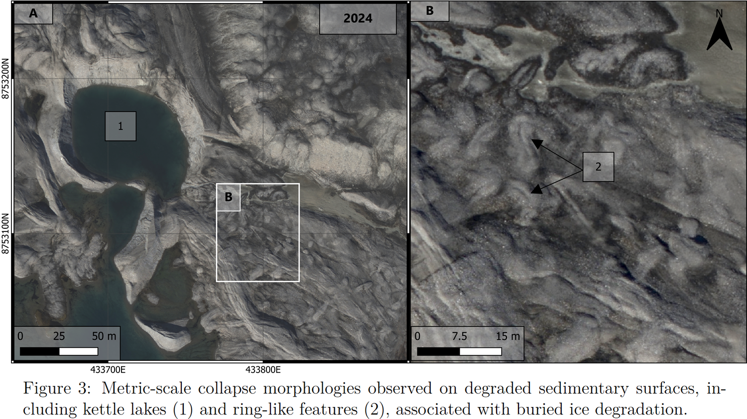
At regional scale, the retreat of the glacier fronts led to the reshaping of large surfaces occupied by ice-cored ground moraines, overlain by sedimentary deposits. At intermediate scales, these processes manifest through the evolution of coastal fluvio-glacial fans, from their development and abandonment to their collapse due to buried ice degradation, as shown by kettle holes and thermokarsts. At smaller scales, the surface of these fans display collapse morphologies, including kettle holes and ring-like features linked to buried ice degradation.
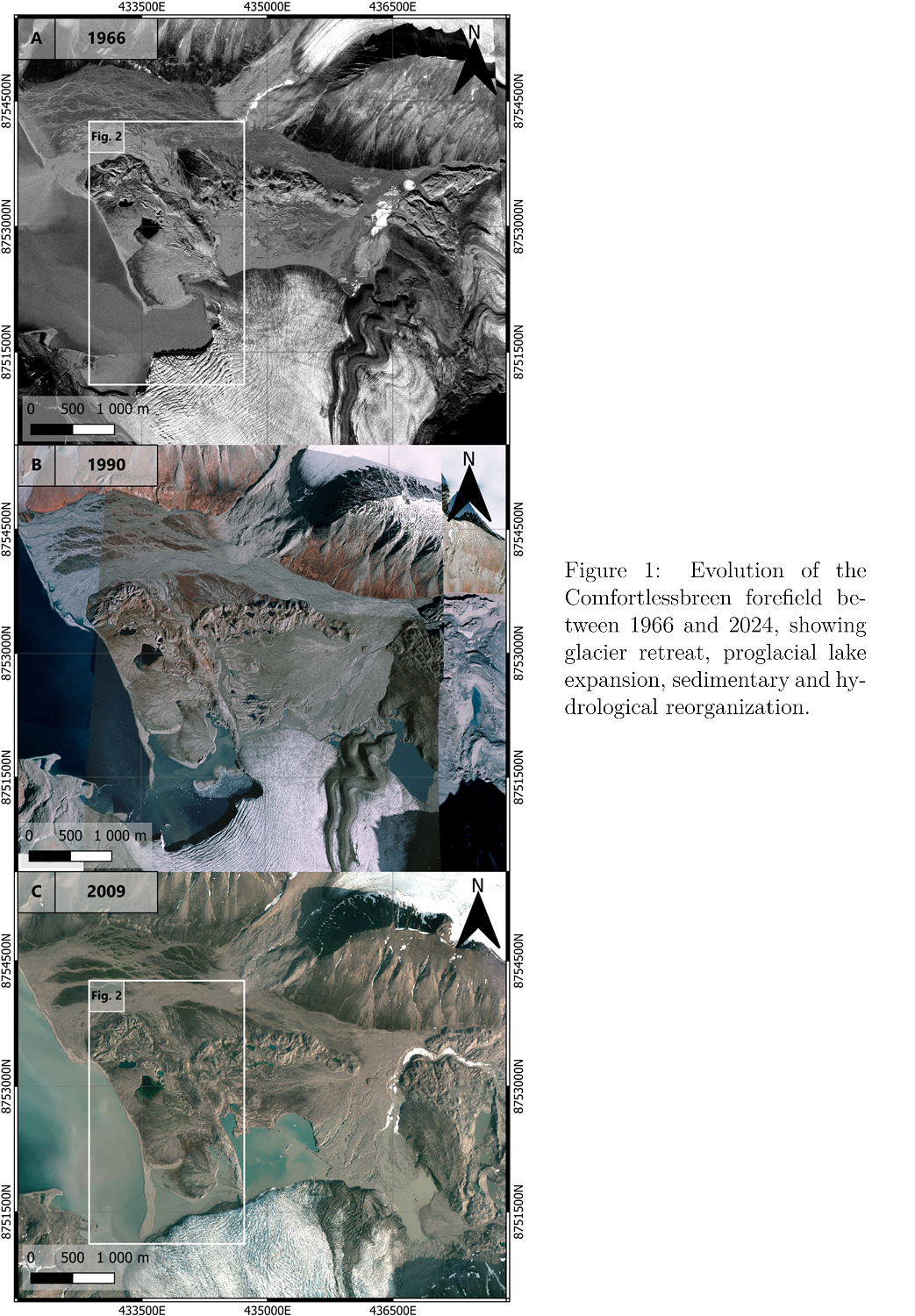
Multi-temporal observations reveal rapid landscape reorganization over the last decades, mainly driven by glacial retreat (Figure 1). The withdrawal of Comfortlessbreen between 1966 and 2024 exposed ice-rich subglacial terrains, which degraded, collapsing the overlying sediments. This process resulted in the formation of a proglacial lake system in two decades.
Sedimentary fan dynamics
The fans observed are connected to glacier activity and meltwater circulation. Two main processes control these structures formation: long-term meltwater runoff, responsible for the construction of the large outwash fan, and sediment-laden water pulses released from the glacier, associated with post-surge activity, responsible for the sedimentary fans located near the shoreline (Figure 2).
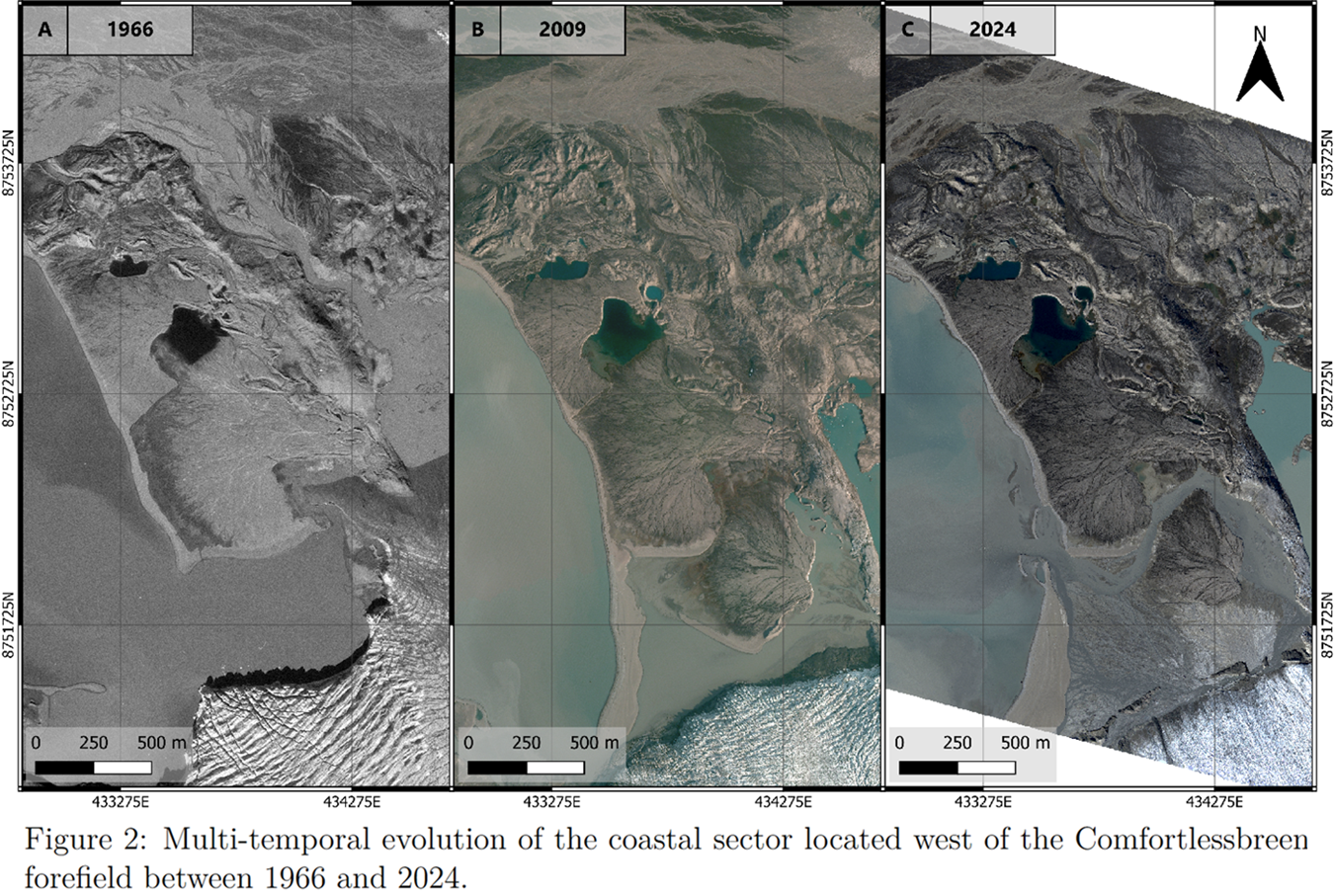
Several of these fans display evidence of polyphased evolution, with successive deposits partially overlapping older units. In some instances, abandoned fan surfaces are destabilized by buried ice degradation, while newer pulses reorganize the drainage system. The organisation of these structures suggest a topographic control of the surrounding bedrock ridges and former glacier margins on the present proglacial landscape.
Collapse terrains
The difference in collapse features distribution between the coastal fans and the large inner outwash fan, suggests that different depositional processes resulted in distinct buried ice organisation, controlling the patterns. For instance, on the large outwash fan developing near the proglacial lake, trench-like features appear aligned along former moraine ridges or sedimentary structures, indicating that buried ice preservation may have been influenced by glacial topography (Figure 3). Such morphologies have been described in association with thermokarst processes and buried ice collapse in Arctic environments, making this setting potentially relevant as analogue for Mars cold-climate landforms.
Additional thermal imagery datasets reveal strong spatial relationships between cold water ponds and terrains enriched in ring-like features. These observations support the interpretation that buried ice degradation is still active.
Conclusion
These rapidly evolving Arctic proglacial systems provide valuable analogues for understanding the formation and preservation of collapsed cold-climate landforms on Mars. Our observations show that buried ice degradation influences landscape evolution, hydrological reorganization, and surface morphology, offering insights into the origin of Martian terrains potentially linked to former glacial activity.
References
E. Hauber et al,. Landscape evolution in martian mid-latitude regions: insights from analogous periglacial landforms in svalbard. Geological Society, London, Special Publications, 2011.
S. M. Hibbard et al,. Glacial ring forms on axel heiberg island, nunavut, Canada. The Cryosphere, 2025.
Jan Kavan et al,. Glacier surge as a trigger for the fastest delta growth in the arctic. Communications Earth & Environment, 2024.
How to cite: Berquez, S., Johnsson, A., Conway, S., Sassenroth, C., Johnson, M., Angelopoulos, M., Bucher, T., Hallet, B., Hauber, E., Hiesinger, H., Kavan, J., Schmedemann, N., and Zanetti, M.: Buried Ice Degradation and Rapid Proglacial Landscape Evolution in Svalbard: Implications for Martian Cold-Climate Geomorphology, Europlanet Science Congress 2026, The Hague, The Netherlands, 6–11 Sep 2026, EPSC2026-938, https://doi.org/10.5194/epsc2026-938, 2026.


