
 1,1,1,1,2,4,1
- 1Osservatorio Astronomico di Padova (OAPD), Istituto Nazionale di Astrofisica (INAF), Padova, Italy
- 2Instituto Argentino de Nivología, Glaciología y Ciencias Ambientales, CCT CONICET, 5500 Mendoza, Argentina
- 3University of Padova, Department of Land, Environment, Agriculture and Forestry - TESAF, Padova, Italy
- 4University of Padova, Department of Geosciences, Padova, Italy
Introduction: Martian glacier-like forms (GLFs) [1] represent some of the most important indicators of past ice accumulation and volatile redistribution in the Martian mid-latitudes. Their morphology preserves evidence of glacial and periglacial processes potentially linked to climatic and obliquity-driven fluctuations. However, despite the widespread occurrence of these landforms, the relationship between surface morphologies, preservation state, and internal ice content remains poorly constrained. In particular, the interpretation of morphometric signatures derived from orbital datasets in the context of Martian GLFs still lacks robust validation, limiting our understanding of the climatic evolution and present-day stability of Martian mid-latitude ice reservoirs.
In this work, we apply a comparative geomorphological approach between Martian GLFs and terrestrial rock glaciers in the Dry Argentine Andes. The terrestrial analogues investigated include the Dos Lenguas rock glacier [2] and the Morenas Coloradas rock glacier complex. Dos Lenguas is an active tongue-shaped rock glacier located in the upper Agua Negra basin (~30°S), characterized by well-developed ridge-and-furrow systems, compressional structures, and active creep processes. Previous studies highlighted significant surface kinematics and topographic variability associated with active permafrost deformation and internal ice-rich conditions [3]. The Morenas Coloradas complex instead represents an ice-debris-complex which consists of complex landforms, transitioning from debris-covered glaciers or ice-cored moraines into rock glaciers downslope [4, 5].
The main goal of this study is to investigate whether quantitative morphometric parameters derived from DTMs can provide diagnostic indicators of ice preservation, degradation state, and flow-related processes on Martian GLFs, using the terrestrial analogues to support the comparison and validation of morphometric signatures.
Methods: We start producing a preliminary global database of Martian GLFs, from which representative targets were selected for detailed analyses based on preservation state, geological context, and the availability of high-resolution datasets. The high-resolution investigations rely on HiRISE [6] and CaSSIS [7] imagery and DTMs, which we used as the basis for our morphometric analyses. The analyses focus on the characterization of ridge spacing, ridge-and-furrow systems, surface textures, slope variability, and longitudinal and transverse topographic profiles. Ridge spacing measurements were performed by manually tracing ridge crests on QGIS. Distances between adjacent ridges were then calculated along transects approximately perpendicular to the dominant ridge orientation and parallel to the runout direction.
To aid the interpretation of Martian landforms, a dedicated field campaign was conducted in March 2026 in the Central Andes of Argentina on the Dos Lenguas and Morenas Coloradas rock glaciers (Fig. 1) in collaboration with the IANIGLA-CONICET institute (Mendoza, Argentina). UAV surveys were performed across active, transitional, and relict sectors of rock glaciers in order to acquire very high-resolution imagery suitable for photogrammetric reconstruction and DTM generation. The campaign also included geomorphological observations focused on ridge morphology, surface texture variability and frontal structures.
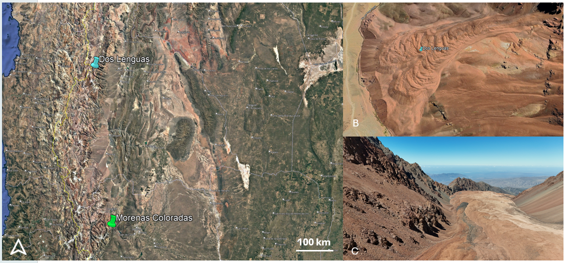
Fig. 1 – Google Earth view shows the location of the two rock glaciers studied in Argentina. B) Dos Lenguas rock glacier from Google Earth. C) Photo taken by drone of Morenas Coloradas rock glacier (credit Andrés Lo Vecchio).
Preliminary observations on Mars:
We selected a first Martian rock glacier located north of Reull Vallis (Fig. 2), along the eastern margin of Hellas Planitia. The area is characterized by multiple flow-related features, GLFs, and Lobate Debris Aprons, supporting a periglacial origin for these landforms.
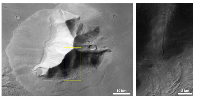
Fig. 2 – The location of the rock glacier-like features, highlighted by the yellow boxes (details in the right picture)
Preliminary geomorphological observations of this rock glacier suggest that some large-scale ridge systems may deform and reorganize pre-existing brain-terrain textures [8]. Smaller-scale surface textures appear progressively compressed, stretched, and locally reoriented along the flanks and crests of the major ridges (Fig. 3). These relationships suggest that the observed morphologies may not represent a single-stage surface texture, but rather the superposition of multiple deformation phases affecting the ice-rich landform.
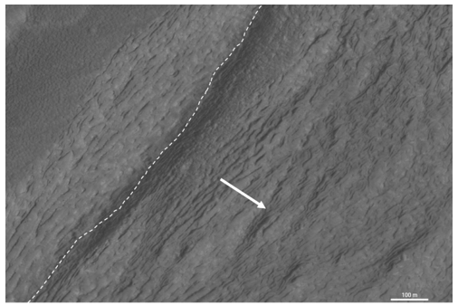
Fig. 3: A detailed view of one of the ridges. The dashed line indicates the crest and the arrow the direction of the flow.
The morphometric measurements performed on the GLFs reveal the presence of two distinct ridge-spacing populations. The smaller-scale ridges exhibit regular spacing ranging between ~56 and 114 m, with an average spacing of ~90 m, forming closely spaced and laterally continuous surface textures. Larger ridge systems display wider and more irregular spacing (~240–505 m, Fig. 4), and are associated with more pronounced topographic relief and large-scale compressional structures. The transition between these two morphologic domains appears gradual, with the smaller-scale textures becoming progressively compressed and reorganized toward the larger ridge systems. These observations suggest a hierarchical surface organization potentially linked to different scales or generations of deformation within the landform. In particular, the smaller and more regularly spaced ridges may reflect an earlier phase of surface texturing or distributed deformation, whereas the larger ridge systems may represent later localized compressional creep structures developed during the subsequent evolution of the GLF.
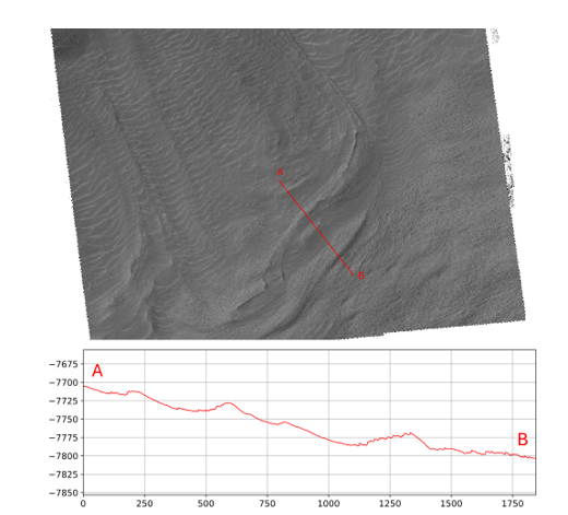
Fig. 4: The section A-B shows the topographic profile, which highlight the larger ridges.
Next step: The work comprehends comparative analyses of both Martian and terrestrial rock glaciers. The generation of high-resolution DTMs for the Dry Andean analogues is currently ongoing, while additional Martian GLFs will be investigated as new topographic datasets from CaSSIS and HiRISE become available.
Acknowledgements: This work has been developed under the ASI-INAF agreement n. 2024- 40-HH.0. We thank the IANIGLA-CONICET team for logistical and scientific support during the field campaign in the Andes.
References:
[1] Driver G., et al. (2024). Journal of Geophysical Research: Planets, 129.
[2] Halla C. et al. (2021) The Cryosphere, 15, 1187–1213.
[3] Tapia-Baldis, C. and Trombotto-Liaudat, D. (2020). Cuadernos de Investigación Geográfica, 46, 33–58.
[4] Blöthe, J.H. et al. (2021). Earth Surf. Process. Landforms 46, 504–522.
[5] Haeberli, W. et al. (2024). The Cryosphere 18, 1669–1683.
[6] McEwen A. S., et al. (2007). Journal of Geophysical Research: Planets, 112.
[7] Thomas N., et al. (2017). Space Science Reviews, 212.
[8] Levy J., Head J., and Marchant D. (2009). J. Geophys. Res., 114.
How to cite: Bertoli, S., Costa, N., Munaretto, G., Tullo, A., Tapia, C., Lo Vecchio, A., Seco, J. L., Morino, C., Massironi, M., Cremonese, G., and Re, C.: Terrestrial analogues for Martian glacier-like forms: insights from rock glaciers in the Dry Andes of Argentine., Europlanet Science Congress 2026, The Hague, The Netherlands, 7–11 Sep 2026, EPSC2026-939, https://doi.org/10.5194/epsc2026-939, 2026.


