Session 5 | Urban society with fibre sensing
Urban society with fibre sensing
Conveners: Laura Pinzon-Rincon, Shihao Yuan, Pierpaolo Boffi
Orals
| Thu, 03 Sep, 09:00–11:30|Lecture room
Posters
| Attendance Thu, 03 Sep, 17:00–18:00|Poster area
Orals |
Thu, 09:00
Thu, 17:00
This session focuses on the use of fibre-optic sensing to observe, understand, and manage complex urban systems. Beyond the sensing technologies themselves, it highlights how fibre-optic measurements are integrated into the built environment to support resilient, safe, sustainable, and smart cities.

Topics include, but are not limited to: urban subsurface characterization and ground stability monitoring; earthquake detection, early warning, and urban hazard assessment; structural health monitoring of critical infrastructure such as bridges, tunnels, and buildings; transportation and mobility sensing across rail and road networks; environmental monitoring in urban settings; monitoring of utilities and energy systems, including pipelines and power cables; smart-city sensing using telecommunication fibre networks; multi-physics fibre-optic monitoring; and large-scale data processing, cloud and edge computing, and machine learning for real-time applications.

By bringing together researchers, engineers, and practitioners across geoscience, civil engineering, data science, and urban planning, the session aims to advance the transformative role of fibre-optic sensing for resilient and smart cities.

Orals: Thu, 3 Sep, 09:00–11:30 | Lecture room

Chairpersons: Laura Pinzon-Rincon, Shihao Yuan, Pierpaolo Boffi
09:00–09:20
|
GC14-FibreOptic-104
|
keynote lecture
Celine Hadziioannou and the the WAVE initiative and the Anthroposeis Consortium

Urban environments generate complex seismic wavefields from overlapping anthropogenic and natural sources. These wavefields challenge traditional seismological methods but can also be used to monitor and quantify human impact on the subsurface, infrastructure, and environment in cities. Distributed Acoustic Sensing (DAS) transforms urban seismic monitoring by leveraging existing fiber-optic infrastructure for dense and cost-effective sensing. This opportunistic approach provides unprecedented spatial resolution but requires new analytical frameworks to handle the complexity of the data and the sensitivity of DAS to strain and small-scale heterogeneities.

We consider how DAS can support smart city infrastructure health monitoring, groundwater management, and assessment of climate-driven subsurface changes, enabling more resilient and adaptive cities, but also address the challenges associated with leveraging urban DAS recordings, e.g. complex wavefields, non-traditional sources, and data privacy.

Finally, we will show how DAS sensing systems support high-precision physics experiments such as particle accelerators and gravitational wave observatories, turning research campi into smart science cities.

How to cite: Hadziioannou, C. and the the WAVE initiative and the Anthroposeis Consortium: Monitoring human impact: DAS and the future of urban seismology, Galileo conference: Fibre Optic Sensing in Geosciences, Aussois, France, 31 Aug–4 Sep 2026, GC14-FibreOptic-104, https://doi.org/10.5194/egusphere-gc14-fibreoptic-104, 2026.

09:20–09:30
|
GC14-FibreOptic-64
Verónica Rodríguez Tribaldos, Patricia Martínez-Garzón, Laura Hillmann, Recai Feyiz Kartal, Tuğbay Kılıç, Laura Pinzon-Rincon, Jordi Gómez Jodar, Roberto Barroso Fernández, Zeynep Coşkun, Filiz Tuba Kadirioğlu, Marco Bohnhoff, and Charlotte Krawczyk

Coastal areas are among the most densely populated areas on Earth, with 50% to 70% of the population projected to live in these regions in the next 50-100 years. Many large cities are located along tectonically active coastal areas, and the combination of increasing population, sea-level rise, and extreme weather events expose coastal regions to significant geohazard risk. Therefore, detailed characterization of the structure, physical properties and dynamics of the shallow subsurface in coastal urban areas is critical for geohazard assessment and mitigation. However, this task remains challenging, mostly due to limited access to the subsurface for the deployment of conventional sensors. In this context, Distributed Acoustic Sensing (DAS) deployed on existing, unused (“dark”) telecommunication networks offers an unprecedented opportunity to efficiently investigate subsurface seismic structure at high spatial and temporal resolution over tens of kilometers.

In this study, we establish an amphibious fiber-optic sensing testbed to investigate the subsurface structure and dynamics of the megacity of Istanbul (Türkiye) and the eastern Marmara Sea, one of Europe's highest earthquake risk areas. Istanbul is located approximately 20 km north of the North Anatolia Fault Zone (NAFZ), one of the World's most active faults. Since 2015, the GFZ Helmholtz Centre for Geosciences is operating the Geophysical Observatory at the Northern Anatolian Fault (GONAF) in collaboration with the Turkish Disaster and Emergency Management Presidency (AFAD). The observatory consists of 10 boreholes equipped with seismometer strings and partly with strainmeters, providing key information on seismicity and deformation processes in the Marmara Sea. Despite this efforts, high-resolution imaging of the NAFZ, and continuous recording of near-fault seismicity, aseismic deformation and slow-slip events remains challenging. Detailed data on near-city fault complexity, potential hidden faults directly underneath the urban area, and the spatial variability of subsurface material properties at high resolution is also still lacking. By integrating fiber-optics sensing, we expand and enhance the observatory by simultaneously providing critical data on offshore fault structure and seismicity and enabling efficient investigation of structure and seismic hazard along the coast.

Since May 2024, continuous passive seismic data have been recorded along two dark fibers in eastern Istanbul: a 17 km-long cable crossing the coastal district of Kartal, and a 34 km-long cable immediately offshore, connecting the coast with the Princess Islands. Both natural (i.e. ocean waves) and anthropogenic (traffic) seismic noise, as well as local and regional earthquakes have been captured by both fibers, enabling the characterization of the testbed and its potential and limitations. We apply ambient seismic noise interferometry approaches across multiple spatial scales and frequency bands for multi-resolution imaging, and explore the potential for temporal monitoring of subsurface variations associated with earthquake processes and environmental changes. We also assess the capabilities of the testbed to detect near-fault seismic events and improve seismicity catalogs. Ultimately, our study will provide a framework to leverage dark fibers in densely populated coastal areas for efficient subsurface imaging and near-fault monitoring, with significant potential to improve geohazard assessment.

How to cite: Rodríguez Tribaldos, V., Martínez-Garzón, P., Hillmann, L., Kartal, R. F., Kılıç, T., Pinzon-Rincon, L., Gómez Jodar, J., Barroso Fernández, R., Coşkun, Z., Kadirioğlu, F. T., Bohnhoff, M., and Krawczyk, C.: Fiber-optic sensing for subsurface investigation in coastal areas at risk: Istanbul and the Sea of Marmara, Galileo conference: Fibre Optic Sensing in Geosciences, Aussois, France, 31 Aug–4 Sep 2026, GC14-FibreOptic-64, https://doi.org/10.5194/egusphere-gc14-fibreoptic-64, 2026.

09:30–09:40
|
GC14-FibreOptic-107
Eoghan Totten, Chris Bean, and Gareth O'Brien

Detailed images for determining fine-scale geological structure are often best achieved through seismic reflections, which are sensitive to velocity gradients. Through application in a ‘big data’ framework with closely spaced receivers and shots, the hydrocarbons industry has demonstrated just how effective this approach can be. However, both the logistical effort and expense of this implementation are prohibitive for most applications. Recently, DAS is democratising the realm of big data, at least on the receiver side. The question we ask is: can we use DAS receiver ‘big data’ for high-resolution imaging, even in the absence of ‘big data’ on the source side?

Here, we propose a way forward using Fourier Neural Operators (FNOs), which are powerful at mapping between functions (e.g. a seismic wavefield and velocity models). As a proof of concept in the numerical domain, we use FNOs to invert for 2D P-wave velocity models from single earthquake gathers.

We first create a dataset of 35,000 2D velocity models with depth-wise gradients representative of Icelandic crust, perturbed by up to 25% with anti-persistent Von Kármán series and 1000 m correlation lengths. About 15% of these models contain fine-scale geological ‘dyke-like’ structures. Secondly, we forward model the wavefield gathers through each velocity model using SPECFEM2D, accounting for attenuation and broadband source properties. Thirdly, we train a Fourier Neural Operator (FNO) to predict 2D P-wave velocity models from single earthquake gathers. We show that FNO performance generalises to unseen earthquake gathers not included during training, recovering fine-scale velocity structure, including the dykes, from a single gather. In effect, this approach pushes the ‘big data’ requirement for the source side into the numerical domain used for training.

Notwithstanding challenges associated with field DAS instrument response variations, applying this approach to DAS data may open the possibility of high-resolution seismic imagery from a single to a few earthquakes in the field, and may have applications where DAS-enabled high-resolution body wave images can be obtained in regions with exceptionally low seismicity rates and where sufficient body waves cannot be extracted from ambient noise.  

How to cite: Totten, E., Bean, C., and O'Brien, G.: Towards high-resolution local earthquake body-wave imaging using DAS in areas with exceptionally low seismicity rates, Galileo conference: Fibre Optic Sensing in Geosciences, Aussois, France, 31 Aug–4 Sep 2026, GC14-FibreOptic-107, https://doi.org/10.5194/egusphere-gc14-fibreoptic-107, 2026.

09:40–09:50
|
GC14-FibreOptic-6
Etienne Rochat and Fabrizio Buccheri

Distributed fibre optic sensing (DFOS) is using one or a combination of the three available physical backscattering phenomena, namely Rayleigh, Brillouin, and Raman, to provide full length coverage at meter scale of vibration, temperature and strain measurements. The fibre optic cable (FOC) is the sensing medium. Its robustness, flexibility, and low loss together with its insensitivity to any electro-magnetic perturbation makes it a unique tool for sensing in modern urban societies.

Temperature (DTS) and acoustic (DAS) measurements are deployed onshore and offshore for power cable monitoring. Offshore, the DTS temperature signal is used to dynamically handle the load, detect potentially damaging hot spots and assess cable deburial. As a by-product, it gives information on the seabed mobility and on the ocean bottom temperature. Both offshore and on land, the DAS acoustic information provides almost instantaneous cable fault position, thus shortening power cut from usually many months to a few weeks. In addition, it provides information on waves, traffic, and seismic activity.

Strain (DSS) measurements are used for structural health monitoring (SHM), looking at tunnels, bridges, dam, in view of preventing potential failures. DSS can also be used along pipeline right of way in challenging terrains for early detection of geohazard that may result in massive landslide and ultimately in pipeline rupture.

The DFOS value for the society is not so much in its capacity to measure, but in the information that it provides on an asset so that meaningful decisions can be taken. Thus, it is not the backscattering that matters but the application understanding and the data software processing which become key to the deployment and efficiency of fibre-based monitoring. For instance, it is the DTS driven finite element modelling of heat propagation in the seabed that provides the depth of burial estimation. Likewise, it is the complex machine learning based DAS processing that provides intrusion detection.

Based on years of field data, using all the DFOS principles and the associated software, we will show how DFOS is being used in modern societies and what valuable data can be extracted from the asset.

How to cite: Rochat, E. and Buccheri, F.: Distributed fibre optic sensing as a versatile monitoring tool for modern societies, Galileo conference: Fibre Optic Sensing in Geosciences, Aussois, France, 31 Aug–4 Sep 2026, GC14-FibreOptic-6, https://doi.org/10.5194/egusphere-gc14-fibreoptic-6, 2026.

09:50–10:00
|
GC14-FibreOptic-22
|
ECS
Luc Moutote, Marc Whatelet, and Philippe Guéguen

Since its release in 2005, the open-source Geopsy software has become a well-established tool for analyzing ambient vibrations and characterizing seismic sites through its user-friendly and efficient graphical interface. Although it was originally designed for standard sensors such as geophones and nodal arrays, Geopsy is evolving to keep pace with the increasing popularity of Distributed Acoustic Sensing (DAS).

We introduces a new Geopsy plugin specifically designed to handle the large, high-density datasets produced by fiber optic sensing. Our aim is to provide Geopsy users with a Graphical User Interface that is free from heavy coding requirements and allows seismologists to easily visualize and process massive DAS data streams, specifically while on the field. Users can quickly scroll through thousands of channels and multiple files simultaneously, enabling immediate quality control and preliminary analysis right after acquisition. It eliminates complex and heavy scripting to handle DAS datasets while maintaining high compatibility with existing Geopsy processing tools.

Geopsy-DAS includes an intuitive Geo-referencing module to easily map DAS channels to physical coordinates using sparse reference points. Specific features, such as tap tests, fiber symmetries or traffic can be pinpointed directly from the graphical trace display and Geo-referenced to refine the fiber path geometry. Once the channels have been set, the data can be easily processed with usual Geospy modules (filters, spectrograms, correlations, H/V, F-K, MASW, etc.) and take advantage of Geopsy powerful low-level processing capabilities. The plug-in also offers intuitive channel selection, enabling specific signal features to be tracked and extracted from large datasets across multiple files for a dedicated processing.

We demonstrate Geopsy-DAS in an experiment conducted in Grenoble, France, involving 12 km of 'dark fiber' running under a tramway line and across the city. Despite having almost no prior knowledge of the cable's path or the quality of its coupling, we successfully mapped its geometry. We identified and monitored various urban structures along the fiber, including several bridges, and captured their vibration response (damping, spatial coherence, etc.). It demonstrates the efficiency of the Geopsy GUI in handling DAS data for monitoring structural integrity and site characterization in noisy, complex environments, while maintaining high computing performance and a user-friendly interface.

How to cite: Moutote, L., Whatelet, M., and Guéguen, P.: GEOPSY-DAS: An Interactive Plugin for Fast Visualization and Integration of Distributed Acoustic Sensing (DAS) in Ambient Vibration Processing, Galileo conference: Fibre Optic Sensing in Geosciences, Aussois, France, 31 Aug–4 Sep 2026, GC14-FibreOptic-22, https://doi.org/10.5194/egusphere-gc14-fibreoptic-22, 2026.

Coffee break
Chairpersons: Laura Pinzon-Rincon, Shihao Yuan, Pierpaolo Boffi
10:30–10:40
|
GC14-FibreOptic-2
|
ECS
Le Tang, Etienne Bertrand, Eléonore Stutzmann, Luis Fabian Bonilla Hidalgo, Shoaib Ayjaz Mohammed, Céline Gélis, Sebastien Hok, Maximilien Lehujeur, Donatienne Leparoux, Gautier Gugole, and Olivier Durand

Distributed Acoustic Sensing (DAS) is an emerging technology that transforms fiber-optic cables into dense arrays of vibration sensors, offering significant potential for subsurface exploration in urban environments. DAS enables the recording of broadband ground vibrations generated by human activity, including both high-frequency seismic wavefields (>1 Hz) and low-frequency quasi-static deformations (<1 Hz). However, effectively exploiting these signals and leveraging the dense spatial sampling of DAS in complex and highly heterogeneous urban subsurface environments, still remains a major challenge. In this study, we propose two novel approaches for local structural imaging based on seismic surface waves and quasi-static deformation. The first method uses high-frequency surface waves and a gradient-based amplitude estimation technique to achieve local structural imaging using only two DAS channels. Under the assumption of laterally heterogeneous JWKB theory, the ratio of the first-order temporal derivative to the spatial derivative of the surface-wave strain rate is used to estimate the local phase velocity. This approach allows adjacent DAS channels to resolve local one-dimensional velocity structures. The performance of this method is validated through numerical simulations and field experiments. The second method focuses on low-frequency quasi-static strain-rate signals induced by vehicle loading, enabling local structural imaging using a single DAS channel. A Markov Chain Monte Carlo (MCMC) inversion framework is used to investigate the depth sensitivity of quasi-static strain signals. Synthetic results indicate that the quasi-static strain field generated by a typical passenger vehicle can resolve subsurface structures at depths from 0 to10 m. Furthermore, field experiments conducted near a highway show that the derived two-dimensional velocity model is consistent with results obtained from conventional surface-wave inversion methods, confirming the robustness and applicability of the proposed approach. Looking ahead, the widespread deployment of urban fiber-optic communication networks provides an unprecedented opportunity to record broadband vibration signals from diverse sources, enabling large-scale urban subsurface imaging. These methods have promising applications in urban infrastructure design and hazard assessment.

How to cite: Tang, L., Bertrand, E., Stutzmann, E., Bonilla Hidalgo, L. F., Mohammed, S. A., Gélis, C., Hok, S., Lehujeur, M., Leparoux, D., Gugole, G., and Durand, O.: Urban Subsurface Imaging with DAS: From Seismic Wavefields to Quasi-Static Deformation, Galileo conference: Fibre Optic Sensing in Geosciences, Aussois, France, 31 Aug–4 Sep 2026, GC14-FibreOptic-2, https://doi.org/10.5194/egusphere-gc14-fibreoptic-2, 2026.

10:40–10:50
|
GC14-FibreOptic-62
|
ECS
Bruna Chagas de Melo, Christopher J. Bean, and Colm Browning

Rapid urban growth in Dublin is placing increasing pressure on transport, construction, and environmental management, creating a need for high-resolution observations of how the city operates at both surface and subsurface levels. This study presents progress from a project exploring the use of existing telecommunication infrastructure as a large-scale urban sensing platform through Distributed Strain Sensing (DSS), which converts optical fibres into dense seismic arrays by measuring strain-rate perturbations from ground vibrations.

A pilot deployment was carried out on a dark ~80 km fibre ring crossing Dublin city centre, residential neighbourhoods, surface tram lines, and a tunnel. A FEBUS-A1 interrogator was installed at a data centre in Dublin's north side and operated for 23 days. The most stable configuration recorded ~50 km of fibre at 500 Hz sampling and 20 m gauge length over a continuous 10-day period. The array captured clear signatures of moving vehicles and rail activity. Signal quality degrades beyond ~30 km from the interrogator, reflecting attenuation, coupling, and urban noise effects typical of long fibre links.

Now we aim to use the Luas tram network as a calibrated moving load to extract quantitative information from the DSS data. The fibre intersects the Luas Red Line over a ~1.5 km section, where the uniform fleet of Alstom Citadis 401 trams (40.8 m, 3 bogies, ~41 t tare weight) provides a recurring, well-characterised seismic source. The signal also enables refined georeferencing of channel locations: tram stops are clearly identified as ~1-minute gaps in the spatio-temporal record, providing fixed spatial anchors along the fibre. Because the trams follow a fixed schedule with known geometry, they are ideal for validating the quasi-static response of buried telecom fibre to vehicular loading, characterising fibre–ground coupling along the section, and developing a workflow to estimate tram weight — and by extension passenger load — from the quasi-static strain amplitude. We plan to follow the processing pipeline — event detection, speed estimation from spatial-temporal moveout, channel-by-channel coupling correction, and absolute calibration anchored on the known tare weight — and discuss the physical assumptions underpinning weight retrieval from fibre in telecom ducts rather than bonded to the ground. Beyond passenger-load tracking, this approach establishes the Luas as an in-situ calibration standard transferable to other vehicles and fibre sections, opening a route toward distributed weight-in-motion monitoring across urban environments.

How to cite: Chagas de Melo, B., Bean, C. J., and Browning, C.: Distributed Strain Sensing on a Dublin Telecom Fibre: The Luas Tram Network as a Moving Calibration Source, Galileo conference: Fibre Optic Sensing in Geosciences, Aussois, France, 31 Aug–4 Sep 2026, GC14-FibreOptic-62, https://doi.org/10.5194/egusphere-gc14-fibreoptic-62, 2026.

10:50–11:00
|
GC14-FibreOptic-19
|
ECS
Joseph Grand, Luis-Fabian Bonilla, Eleonore Stutzmann, Baldrik Faure, Tarik Hammi, and Gabriel Papaiz

The modern French railway network is equipped with optical fibers dedicated to telecommunication purposes, among which some remain unused. These so-called dark fibers can be exploited using Distributed Acoustic Sensing technology (DAS) to provide an effective tool for rapid assessment and long-term monitoring of site conditions along railway tracks. We present a methodology applied to a 19 km long DAS array operating under normal railway traffic conditions, highlighting the capability to perform continuous spatial analysis at kilometer scale with measurements every 4.9 meters. Despite the limited coupling associated with the on-conduit installation, corresponding to the standard operational conditions without any modification to the existing infrastructure, time windows selected before and after train passages allow the extraction of the resonance frequencies at each DAS channel, overcoming the low signal-to-noise ratio of the installation setup. Variations of resonance frequencies along the railway reflect changes in near surface soil conditions, related either to shear wave velocity or to variation in impedance contrast depth, with rapid spatial variation observed in karstic areas over only a few tens of meters. The novelty of this work lies in the use of resonance frequencies as a stable and repeatable site parameter derived from DAS data on a large scale. While this information does not quantify site amplification, it provides direct information on the frequency ranges that may be preferentially amplified. This makes them well suited for long term monitoring and for tracking temporal or spatial changes in site conditions under linear infrastructures, and for supporting future strategies to manage infrastructure evolution and time dependent variability. Seasonal variations of these resonance frequencies have been observed, further supporting this method as an effective tool for continuous site monitoring.

How to cite: Grand, J., Bonilla, L.-F., Stutzmann, E., Faure, B., Hammi, T., and Papaiz, G.: Toward large scale assessment of railway site conditions using brodaband resonance frequencies from DAS DATA , Galileo conference: Fibre Optic Sensing in Geosciences, Aussois, France, 31 Aug–4 Sep 2026, GC14-FibreOptic-19, https://doi.org/10.5194/egusphere-gc14-fibreoptic-19, 2026.

11:00–11:10
|
GC14-FibreOptic-65
Andreas Wuestefeld, Christiane Duscha, Boris Adum, and Bjørn Egil Nygaard

Dynamic Line Rating (DLR) is a method employed by grid operators to maximise electrical use of powerlines. This requires detailed knowledge of conditions of the powerlines themselves, and also environmental conditions at high spatio-temporal resolution. Wind is particularly interesting as it both cools the conductor and induces conductor motion. Under certain conditions, wind excitation can lead to large-amplitude instabilities such as conductor galloping which can cause damage to the power line. Recent advances in distributed fibre-optic sensing (DFOS), particularly Distributed Acoustic Sensing (DAS) enables continuous monitoring of conductor movement over hundreds of kilometres of optical ground wire (OPGW) or phase conductors equipped with optical fibres, offering unprecedented spatial resolution for infrastructure monitoring.

In this contribution, we present a methodology to exploit conductor vibration measurements obtained via DAS to infer wind velocities and detect incipient galloping events. These measurements thus provide actionable environmental information for transmission grid operation.

A key processing step is the extraction of harmonic components from the vibration spectra. Aeolian vibrations and galloping manifest in distinct frequency bands and modal structures. By performing automated spectral peak detection and tracking of harmonic modes, we derive robust features that are sensitive to wind speed via Strouhal-type relationships, while also capturing changes in mechanical boundary conditions. We present here first results of two installation on OPGWs (15km and 55km) the mountains of central Norway during the winter of 2025/2026.

Furthermore, we demonstrate that galloping events can be identified through the emergence of low-frequency, high-amplitude oscillations with characteristic harmonic signatures. Real-time monitoring of these spectral features enables early warning of critical events, supporting proactive grid operation and risk mitigation. The ability to monitor such phenomena continuously along entire transmission corridors represents a significant advancement compared to point-based sensor systems.

By improving the estimate of wind conditions and enabling early detection of extreme loading events, this methodology directly supports Dynamic Line Rating and more efficient utilisation of existing transmission infrastructure. This contributes to the energy transition by increasing grid capacity, facilitating renewable integration, and enhancing the resilience of critical energy systems without the need for extensive new construction.

How to cite: Wuestefeld, A., Duscha, C., Adum, B., and Nygaard, B. E.: Fibre-Optic Wind Monitoring of Overhead Powerlines for Smart and Resilient Power Grids, Galileo conference: Fibre Optic Sensing in Geosciences, Aussois, France, 31 Aug–4 Sep 2026, GC14-FibreOptic-65, https://doi.org/10.5194/egusphere-gc14-fibreoptic-65, 2026.

11:10–11:20
|
GC14-FibreOptic-42
Alan Baird

Distributed Acoustic Sensing (DAS) enables dense, continuous measurements of dynamic strain and is increasingly used to monitor anthropogenic activity. Aircraft generate clear acoustic signals that can be recorded by such arrays, with Doppler frequency shifts providing a direct observable of source motion. Previous seismic and acoustic studies of aircraft have typically relied on sparse sensor networks or single-point measurements, limiting the ability to resolve source–receiver geometry and extract trajectory information. Here we exploit the two-dimensional, multi-arm geometry of the NORFOX fibre array in Norway to track aircraft signals across spatially distributed sensors, providing improved constraints on aircraft kinematics.

We focus on helicopter fly-bys and selected fixed-wing aircraft. For helicopters flying at altitudes of a few hundred metres, we extract Doppler signatures from time–frequency representations of the DAS data and validate these against ADS-B flight records. The observed frequency shifts are consistent with expected aircraft motion, and analysis of the Doppler shifts allows estimation of aircraft speed and source frequency; the latter is related to rotor dynamics and can be used to discriminate between aircraft types. The shape of the Doppler curves, including their slope and temporal extent, is diagnostic of the aircraft's distance at closest approach, providing geometric constraints on the source–receiver configuration. The dense spatial sampling of NORFOX enables these signatures to be tracked across multiple fibre arms, enabling estimation of aircraft trajectories directly from the DAS observations.

For jets, the source frequencies typically exceed the 62.5 Hz Nyquist frequency of the DAS recordings, and Doppler harmonics are therefore not resolved. Nevertheless, coherent lower-frequency arrivals can still be observed, even at cruising altitudes, and analysing their propagation across the array yields time-varying back-azimuth and apparent slowness estimates, providing directional constraints on source motion.

Together, these results demonstrate that array-based DAS deployments can meaningfully enhance aircraft detection and tracking using existing fibre infrastructure. The NORFOX geometry illustrates how fibre layout determines the quality of kinematic information recoverable from such observations.

How to cite: Baird, A.: Detection and Tracking of Aircraft Using the NORFOX Distributed Acoustic Sensing Array, Galileo conference: Fibre Optic Sensing in Geosciences, Aussois, France, 31 Aug–4 Sep 2026, GC14-FibreOptic-42, https://doi.org/10.5194/egusphere-gc14-fibreoptic-42, 2026.

11:20–11:30
|
GC14-FibreOptic-71
|
ECS
Andrea Madaschi, Marco Brunero, and Pierpaolo Boffi

The widespread deployment of optical fiber networks in urban areas by telecommunications operators opens a significant opportunity to transform existing metropolitan area network (MAN) infrastructures into large-scale distributed sensing systems. Beyond their primary communication function, buried fiber-optic cables can act as pervasive sensors for monitoring human activities, natural events, and geoscience-related processes, enabling a cost-effective and non-invasive approach to urban and environmental surveillance. In this context, Distributed Acoustic Sensing (DAS) has emerged as a highly promising technology for detecting and localizing perturbations with high resolution. Despite its remarkable potential, DAS also presents important limitations that can hinder large-scale and long-term deployment in real operational MAN scenarios. In particular, the DAS cost remains relatively high, and the technology requires significant expertise for system configuration, signal interpretation, and maintenance. Moreover, DAS generates an enormous amount of data, creating substantial challenges in terms of storage and data management, especially when continuous monitoring is required. In contrast, interferometric fiber sensing approaches represent an attractive alternative. Although they do not provide the spatial localization capability typical of DAS, they can achieve comparable sensitivity while offering major advantages in terms of reduced system complexity, lower cost, and significantly lighter data handling requirements. These characteristics make interferometric solutions particularly suitable for practical deployments where early warning is more important than precise distributed localization. Their simplified architecture can therefore facilitate the exploitation of in-service urban fiber networks as sensing assets, extending monitoring capabilities to a broader range of users and use cases.

This work presents a direct comparison between these two sensing paradigms through a real field trial carried out on an operational MAN fiber network deployed by the Italian operator OPEN FIBER in the town of Pitigliano, Italy. Pitigliano is an ancient medieval village built on a tuff cliff, a geomorphological setting of high historical and environmental value but also potentially exposed to instability phenomena. In the experiment, an already installed telecom fiber-optic cable buried beneath an unpaved road running along the tuff ridge was exploited as a sensing element to monitor both anthropogenic activities, such as pedestrians and passing vehicles, and potentially dangerous events, such as falling rocks or trees. In perspective, the same sensing infrastructure may also support the observation of possible variations affecting the stability of the tuff cliff itself, thus contributing to geoscientific monitoring and risk mitigation. The entire monitoring system was remotely operated from a service room located at the Municipality of Pitigliano, demonstrating the feasibility of centralized and fully remote management of urban fiber sensing infrastructures. Several comparative measurements obtained with both DAS and a low-cost interferometric system provided by COHAERENTIA (www.cohaerentia.com) are presented and discussed. The results show useful insight into the capabilities of sensing technologies for future smart-city, civil protection, and geoscience applications based on existing telecom fiber networks.

How to cite: Madaschi, A., Brunero, M., and Boffi, P.: DAS vs. Interferometric Monitoring on an Urban Fiber Network: Field Validation in the Tuff Cliff of Pitigliano, Galileo conference: Fibre Optic Sensing in Geosciences, Aussois, France, 31 Aug–4 Sep 2026, GC14-FibreOptic-71, https://doi.org/10.5194/egusphere-gc14-fibreoptic-71, 2026.

Posters: Thu, 3 Sep, 17:00–18:00 | Poster area

P32
|
GC14-FibreOptic-7
Laura Pinzon-Rincon, Verónica Rodríguez Tribaldos, Jordi Gómez Jodar, Roberto Barroso-Fernández, Patricia Martínez-Garzón, Laura Hillmann, Recai Feyiz Kartal, Tuğbay Kılıç, Marco Bohnhoff, and Charlotte Krawczyk

Urban areas are highly vulnerable to geohazards due to their dense populations and infrastructure, often resulting in severe consequences for human life and economic stability. Improving our understanding of near-surface and shallow subsurface structures in urban environments is therefore essential for effective seismic hazard assessment and risk mitigation. However, conventional geophysical surveys in cities are frequently limited by logistical constraints. In this context, repurposing existing telecommunication optical fibers (so-called dark fibers) as dense seismic sensing arrays using Distributed Acoustic Sensing (DAS) offers a powerful alternative for urban subsurface investigations.The megacity of Istanbul (Turkey) is located in one of the most tectonically active regions worldwide and is exposed to significant seismic hazard. Since May 2024, we have been continuously recording passive seismic data using DAS along an amphibious fiber-optic cable deployed in the urban district of Kartal (eastern Istanbul) and extending offshore. In this study, we focus on one month of data acquired along a 3 km-long urban segment of the fiber.
Here, we exploit high-frequency urban noise for passive seismic interferometry. We analyze ambient seismic noise primarily generated by anthropogenic sources, such as urban traffic, in a frequency range up to 12Hz. We adapt ambient noise interferometry processing strategies to address the challenges posed by dense urban environments and DAS array geometries, including the selection of suitable fiber sections, channels, and source–receiver configurations. First, we retrieve high-frequency surface waves along different segments of the fiber. Then, we use these arrivals within an Eikonal tomography framework to map local phase velocities. Finally, we invert the surface-wave dispersion to constrain the shallow subsurface velocity structure, contributing to a better understanding of shallow structures and material properties relevant to seismic hazard assessment. Ultimately, this work aims to establish efficient methodologies for imaging the urban subsurface using existing infrastructure.

How to cite: Pinzon-Rincon, L., Rodríguez Tribaldos, V., Gómez Jodar, J., Barroso-Fernández, R., Martínez-Garzón, P., Hillmann, L., Feyiz Kartal, R., Kılıç, T., Bohnhoff, M., and Krawczyk, C.: Urban Subsurface Seismic Imaging Using Ambient Noise and Dark Fiber Distributed Acoustic Sensing in Istanbul, Galileo conference: Fibre Optic Sensing in Geosciences, Aussois, France, 31 Aug–4 Sep 2026, GC14-FibreOptic-7, https://doi.org/10.5194/egusphere-gc14-fibreoptic-7, 2026.

P33
|
GC14-FibreOptic-14
|
ECS
Ivana Zonjić and Josip Stipčević

The Dubrovnik region of southern Croatia is characterized by complex tectonic interactions along the convergent boundary of the Adriatic microplate and the Dinaric fold-and-thrust belt. To improve seismic monitoring in this high-risk area, we utilize two Distributed Acoustic Sensing (DAS) arrays: a 17 km terrestrial dark-fiber cable and a 40 km hybrid onshore–offshore cable traversing the Adriatic seafloor and nearby islands. While these arrays provide unprecedented spatial sampling, their integration into standard seismological routines requires new automated approaches.
In this work, we present a comparative analysis between a baseline automated workflow using conventional regional seismometers and an augmented framework that incorporates DAS data. We investigate how incorporating dense DAS picks improves earthquake location accuracy and helps detect small events missed by the regional network. By integrating automated phase picks from the DAS arrays with arrival times from the permanent regional network, we demonstrate that combined earthquake locations yield lower spatial uncertainties compared to those derived from the sparse regional network alone. Furthermore, the DAS arrays successfully capture low-magnitude local events that remain below the detection threshold of the standard seismometer stations, thereby lowering the local magnitude of completeness.
A significant observation in our DAS records is the presence of distinct phase conversions (P-to-S) originating from offshore earthquake sources. These converted phases are prominently captured by the dense fiber geometry but pose a challenge for standard automatic picking frameworks. We are currently testing specialized algorithmic solutions within our processing pipeline to accurately identify and utilize these conversions. Successfully characterizing these phases will provide critical constraints on the velocity structure and sediment thickness of the Adriatic shelf.
This poster discusses the technical challenges of multi-instrument integration, the reduction of hypocentral errors through hybrid monitoring, and the ongoing development of picking strategies to handle complex phase arrivals in fiber-optic data. Our results highlight the transformative potential of DAS in complementing traditional networks for high-precision seismic monitoring in complex tectonic settings.

How to cite: Zonjić, I. and Stipčević, J.: Integrating Dense DAS Arrays and Conventional Networks for Earthquake Monitoring in the Southeastern Adriatic Sea region, Galileo conference: Fibre Optic Sensing in Geosciences, Aussois, France, 31 Aug–4 Sep 2026, GC14-FibreOptic-14, https://doi.org/10.5194/egusphere-gc14-fibreoptic-14, 2026.

P34
|
GC14-FibreOptic-30
|
ECS
Jordi Gómez Jodar, Verónica Rodríguez Tribaldos, Laura Pinzon-Rincon, Roberto Barroso-Fernández, Patricia Martínez-Garzón, Laura Hillmann, Recai Feyiz Kartal, Tuğbay Kılıç, Filiz Tuba Kadirioğlu, Marco Bohnhoff, and Charlotte Krawczyk

Urban environments currently host more than 55% of the global population. However, the subsurface of such environments is not well characterized. Conventional geophysical surveys pose logistical challenges, such as restricted access and limitations on the use of active seismic sources, which impede such surveys to be performed. To overcome these challenges, Distributed Acoustic Sensing (DAS) can be deployed on existing, unused telecommunication fibre optic cables (dark fibres) and repurpose them as dense seismic arrays. In this way, the ambient seismic wavefield can be continuously recorded for high-resolution, passive subsurface imaging. However, the seismic noise field present in urban environments is complex, and mostly dominated by anthropogenic activity (i.e., trains, cars…), resulting in transient and moving seismic sources. Besides, dark fibres tend to have complicated layouts. A thorough understanding of the urban seismic noise field recorded by dark fibre DAS arrays is needed to understand the retrieved energy and its potential for seismic imaging.

In this work, we investigate the interaction between diverse noise sources, complex fibre geometries and DAS directional sensitivity, and its impact on the application of ambient noise interferometry for imaging in complex urban environments. Our study area is located in the megacity of Istanbul (Türkiye), a highly densely populated urban area sitting in a region of high earthquake risk. The subsurface structure beneath Istanbul is poorly known, with very limited information available regarding subsurface material properties and faults directly underneath the city. Since May 2024, we have been continuously and simultaneously recording passive DAS data along two dark fibres located on the Eastern side of Istanbul; one crossing the densely populated district of Kartal and another one connecting the coastal section of Kartal with the Princess Islands archipelago, directly offshore.

We start by analysing the ambient noise field recorded along fibre segments with different orientations and at diverse time periods; trying to isolate low-frequency seismic energy generated by natural sources. Combining measurements along both fibres, we apply beamforming approaches to understand the distribution of noise sources with respect to our array, and explore optimal channel-pair configurations to retrieve Rayleigh and Love waves, by taking into account the directional sensitivity of the DAS measurement. Ultimately, our goal is to develop a methodological framework for obtaining a reliable subsurface velocity model using seismic ambient noise in urban areas.

How to cite: Gómez Jodar, J., Rodríguez Tribaldos, V., Pinzon-Rincon, L., Barroso-Fernández, R., Martínez-Garzón, P., Hillmann, L., Kartal, R. F., Kılıç, T., Kadirioğlu, F. T., Bohnhoff, M., and Krawczyk, C.: Understanding Dark Fibre DAS Ambient Seismic Noise recordings in Urban Areas: Implications for Subsurface Imaging in Istanbul, Galileo conference: Fibre Optic Sensing in Geosciences, Aussois, France, 31 Aug–4 Sep 2026, GC14-FibreOptic-30, https://doi.org/10.5194/egusphere-gc14-fibreoptic-30, 2026.

P35
|
GC14-FibreOptic-49
|
ECS
Lucía Fernández Carrascosa, Jesús García Sánchez, Izhan Fakhruzi, José Camacho, and Luz García

Smart cities aim to improve the quality of life of their residents through more efficient management of urban services and infrastructures. In this context, urban traffic monitoring helps improve mobility, reduce congestion, and optimize the management of urban infrastructures. Distributed Acoustic Sensing (DAS) is a particularly attractive technology for urban traffic monitoring in smart cities, since it can take advantage of optical fiber infrastructures already deployed in many urban environments and requires little maintenance. DAS detects vibrations along optical fiber cables generated by external disturbances, such as nearby traffic. With proper feature extraction, these DAS signals can be analyzed to locate events in both time and space, as well as to distinguish between different types of traffic, such as cars, buses, or environmental noise, as illustrated in Fig. 1

Figure 1: Signal labeled by traffic event type


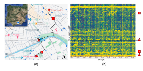
Previous works in Granada (Fig. 2) have explored the use of DAS combined with exploratory data analysis methods to establish a methodological basis for urban traffic monitoring [1]. More recently, neural network-based approaches have also been proposed to automatically recognize traffic events, moving towards real-time monitoring systems without the need for manual labeling of the signals [2].

Figure 2: (a) DAS optical fibre path (b) DAS traffic recording


Our contribution focuses on the application of ASCA (ANOVA-Simultaneous Component Analysis) [3] to DAS signals recorded at different locations in Granada. ASCA is a combination of ANOVA and Principal Component Analysis (PCA) with great capabilities for statistical inference and exploratory data analysis of complex data with a high number of variables. Given the large volume of data and the complexity of the signals, we consider ASCA a suitable methodology to interpret and understand the underlying factors that explain the differences between traffic-related events. Recent works have studied the modelling of spatio-temporal signals with ASCA [4]

Through this approach, we expect not only to support the development of future monitoring systems, but also to develop knowledge and expertise about the structure of DAS data and the patterns present in these signals. Thanks to the interpretability of the analysis, this work is not limited to urban traffic applications, but can also be extended to other domains relevant to geosciences, such as structural health monitoring, seismic analysis, or risk surveillance in critical infrastructures.

[1] I. Fakhruzi, M. Titos, C. Benítez & L. García, “Urban traffic monitoring through Distributed Acoustic Sensing: trial analysis of a potent monitoring tool”.

[2] I. Fakhruzi, M. Titos, C. Benítez & L. García, “Distributed Acoustic Sensing for Urban Traffic Monitoring: Spatio-Temporal Attention in Recurrent Neural Networks”. arXiv:2603.13903, 2026.

[3] Smilde, A. K. et al. (2005). ANOVA-simultaneous component analysis (ASCA): a new tool for analyzing designed metabolomics data. Bioinformatics, 21(13), 3043-3048.

[4] Vallejo-España et al. (2026) Modeling cyclostationarity in time series using ASCA arXiv:2603.05065


This work is part of the MuSTARD project (Multi-scale Spatio-Temporal Analysis of Research Data, https://codas.ugr.es/mustard/en/), funded by grant PID2023-1523010B-IOO from the Spanish Agencia Estatal de Investigación and the European Regional Development Fund.

How to cite: Fernández Carrascosa, L., García Sánchez, J., Fakhruzi, I., Camacho, J., and García, L.: Monitoring urban traffic with Distributed Acoustic Sensing and ANOVA Simultaneous Component Analysis, Galileo conference: Fibre Optic Sensing in Geosciences, Aussois, France, 31 Aug–4 Sep 2026, GC14-FibreOptic-49, https://doi.org/10.5194/egusphere-gc14-fibreoptic-49, 2026.

P36
|
GC14-FibreOptic-78
Christopher Wollin, Rahmantara Trichandi, Veronica Rodriguez Tribaldos, Christian Haberland, Trond Ryberg, Charlotte Krawczyk, and Moritz Kirsch

Industrial mining operations create substantial amounts of residuals known as tailings or waste rocks. Their deposition creates amongst the largest human-made structures in the world both in spatial extent and mass. Their physical stability is not self-evident and tailings dam failures have been regularly documented throughout the world. In order to mitigate environmental and societal risks, stringent regulatory frameworks have been established, e.g. through the Global Industry Standard on Tailings Management (GISTM) in 2020 introduced by The United Nations Environment Programme (UNEP) , which mandates the implementation of monitoring concepts that manage risks throughout the lifecycle of a tailings facility. The EU-funded initiative MOSMIN (Multiscale observation services for mining-related deposits) addresses this key goal by establishing comprehensive monitoring solutions of mining-related deposits. The project combines (remote) Earth observation technologies with ground-based geophysical measurements to produce vertically integrated datasets which are subsequently analysed through advanced computational techniques, including machine learning algorithms, to characterise the spatio-temporal dynamics governing deposition and containment of tailings.


This contribution focuses on fiber-optics-based passive seismic techniques used in MOSMIN to analyse ambient ground vibrations and generate spatially resolved shear-wave velocity models of tailings dams. The ambient noise tomography (ANT) aims at characterizing and monitoring their internal material properties across time and at different scales, resolutions and depths of investigation. We present results from a field campaign at the First Quantum Sentinel copper mine in Kalumbila, Zambia, during which passive seismic data was semi-continuously recorded with a network of passive sensors and a fibre-optic cable for almost a year. The mine’s tailings dam was equipped with 30 autonomous seismic sensors and a 7 km-long, trenched fiber-optic cable installed parallel to the dam structure and interrogated by a commercial Distributed Acoustic Sensing (DAS) system, recording continuous strain-rate data along the cable. The collected seismic data analysed here comprises 9 months of strain-rate recordings across 1.5 km of optic fiber.


To investigate the temporal stability of the ambient seismic wavefield as required for subsurface monitoring purposes, we characterize how it is influenced by ongoing mining activity over weeks to months. We do so by calculating the strain-rate root-mean-square (RMS) in different frequency bands across the entire recording period of the DAS campaign. Further, we discuss the feasibility of retrieving high-resolution velocity profiles of the dam across space and time using Multi-channel Analysis of Surface Waves (MASW). One important aspect is the selection of recording periods with favourable noise conditions. We investigate different strategies for the selective stacking of several thousands of virtual-shot gathers obtained from cross-correlations of 30 s-long time windows. Results show that the MASW workflow is strongly influenced by the influx of anthropogenic noise created by the mining activity during the day time.


Our case study works towards establishing and implementing fibre-optics-based passive seismic surveys, adapted to site-specific requirements, as a scalable, non-invasive framework for geotechnical monitoring of active TSFs. Joint analysis of passive seismic models with satellite-derived surface deformation or spectral information offers potential for improved understanding of surface–subsurface interactions in and along tailings dams.

How to cite: Wollin, C., Trichandi, R., Rodriguez Tribaldos, V., Haberland, C., Ryberg, T., Krawczyk, C., and Kirsch, M.: Geophysical Imaging and Monitoring of Tailings Storage Facilities: A Case Study at the Trident Copper Mine, Zambia, within the MOSMIN Project, Galileo conference: Fibre Optic Sensing in Geosciences, Aussois, France, 31 Aug–4 Sep 2026, GC14-FibreOptic-78, https://doi.org/10.5194/egusphere-gc14-fibreoptic-78, 2026.

P37
|
GC14-FibreOptic-108
|
ECS
Tiago Borges da Silva, George Sand França, and Marcos Futai

The structural assessment of extended railway systems presents persistent challenges for operators responsible for maintaining safety and serviceability across hundreds of kilometers of track and associated infrastructure. Conventional inspection methods offer limited spatial coverage and are poorly suited to detecting geotechnical anomalies at early stages, particularly in complex geological settings. Distributed Acoustic Sensing addresses these limitations by converting optical fiber cables into dense seismic arrays capable of recording ground motion at thousands of points simultaneously, enabling continuous and spatially comprehensive monitoring along entire railway corridors, including the potential reuse of existing telecommunication fiber networks already installed alongside many rail lines.

This study was carried out along one of the longest and most operationally demanding freight railways in northern Brazil, a corridor dedicated to the transport of iron ore in large volumes and to passenger service over extensive distances. Much of the existing distributed sensing literature has focused on high-speed passenger trains as seismic sources. Here, the operative trains are ore freight consists reaching lengths on the order of 3.3 km traveling at speeds between approximately 15 and 30 km/h, alongside shorter maintenance trains, representing a substantially different excitation regime that requires adapted analysis strategies.

An optical fiber approximately one kilometer long was installed parallel to an active section of the railway. Data were acquired during multiple train passages under normal service conditions, capturing the seismic wavefield generated by each transit. Spectral analysis of the recorded signals revealed meaningful variations in the frequency content and energy distribution of surface waves along the fiber, providing evidence of lateral heterogeneities in the mechanical properties of the foundation materials.

The monitored section encompasses a tunnel where geotechnical conditions are of particular concern. Within the tunnel, sandstone and banded iron formation units occur in direct contact alongside basalt dikes, forming a geologically heterogeneous rock mass with quality classifications ranging. The spatial mapping of subsurface stiffness derived from this dataset proved capable of distinguishing zones where support conditions differed from those observed in adjacent sections, pointing to areas of potential concern for long term performance. These observations align with geotechnical expectations regarding the role of differential mechanical behavior across geological contacts in the progressive degradation of tunnel foundations.

Beyond the technical findings, this work contributes to the broader discussion of how fiber optic sensing networks can be integrated into monitoring programs for critical railway infrastructure. The scalability of distributed sensing, the relatively low operational cost of using trains in regular service as seismic sources, and the potential for nearly continuous data acquisition position this approach as a practical option for geotechnical surveillance in complex geological environments. Remaining challenges related to signal coupling and wavefield interpretation in heterogeneous rock masses are discussed in the context of future system development.

How to cite: Borges da Silva, T., Sand França, G., and Futai, M.: Distributed Acoustic Sensing as a Tool for Geotechnical Monitoring Using Seismic Waves Generated by Train Traffic in Northern Brazil, Galileo conference: Fibre Optic Sensing in Geosciences, Aussois, France, 31 Aug–4 Sep 2026, GC14-FibreOptic-108, https://doi.org/10.5194/egusphere-gc14-fibreoptic-108, 2026.