
 ,
,- Planetary Science Institute, Tucson, AZ, USA
Introduction:
Digital terrain models (DTMs) form the basis of many science investigations, including geologic mapping, thermal modeling, and photometric modeling. Previous DTMs were constructed while the Cassini mission was ongoing, and contain limited images. We present global and regional DTMs (i.e., shape models) constructed using the entire Cassini spacecraft imaging campaign and the Stereophotoclinometry (SPC) software suite (Gaskell 2008, 2023). The efficacy of SPC was demonstrated during the OSIRIS-REx mission, where global and regional DTMs successfully guided the spacecraft to the surface of asteroid Bennu 77 cm from the center of the target landing site (Lauretta et al., 2021; Olds et al., 2022). These models are for the Saturnian moons Dione, Mimas, Phoebe, Rhea, and Tethys. Enceladus and Iapetus are forthcoming. These models are freely available on the NASA Planetary Data System (PDS), or will be upon completion.
In addition to the topography and albedo, we also provide detailed photometric data for each vertex of the regional models. For each image, we can provide the reflectance value, phase angle, emission angle, and incidence angle. This photometric data can be used to determine photometric parameters such as geometric albedo, single scattering albedo, and surface roughness for each DTM vertex.
Methods:
SPC uses two proven techniques, stereophotogrammetry and photoclinometry, and simultaneously solves for a single product. The stereophotogrammetry (stereo) solution is accomplished by triangulation of the spacecraft images to a single point on the surface. The multi-image photoclinometric solution uses each pixel from an image along with the image’s incidence and emission angles to calculate an x-slope, y-slope, and albedo for each DTM vertex. Every image contributes to the determination of the slopes and albedo value for each point on the surface. Stereo gives sparse absolute heights, while photoclinometry gives slopes that are then integrated to determine heights in between the stereo positions. The result can be a pixel-to-pixel DTM for the surface, with accurate data for both height and albedo.
Products:
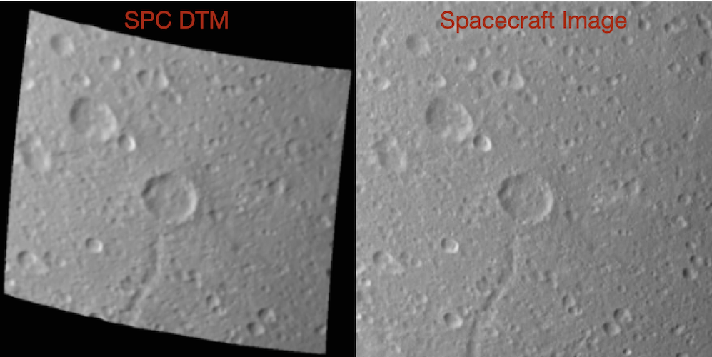
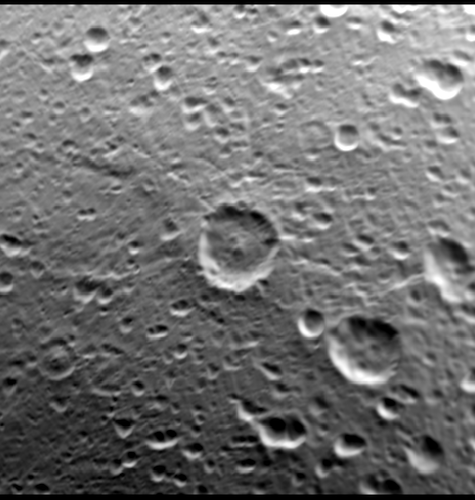
The resulting DTMs can be used to generate views that are nearly indistinguishable from spacecraft images (Fig. 1).
Figure 1. Left shows a regional SPC DTM of Dione centered at -0.3 Lat 293.9 ELon rendered with the same viewing and lighting conditions as the spacecraft image on the right. Spacecraft image is a cropped view of Cassini image N1556123061 (726 m/px resolution).
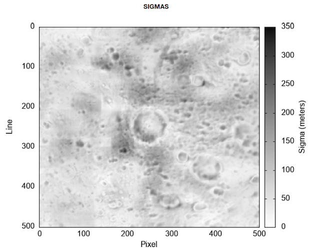
To aid data users, we provide assessment data such as best image resolution and number of images (Fig. 2 and 3). The data in Figs. 2 and 3 indicate where the topography is over- or under-sampled relative to the images, and can be used to determine topographic quality. Additional assessments, such as internal sigma values (Fig. 4), give another check on the quality of the topography. Internal sigma values worse than the best image resolution (a rare occurrence), indicate the sigma values more accurately describe the topographic quality.
Figure 2. Assessment data for regional DTM in Fig. 1. Shows the best image resolution for each vertex of the DTM.
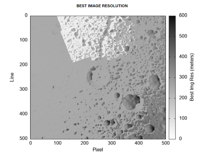
Figure 3. Assessment data for regional DTM in Fig. 1. Shows the number of images used by SPC for each vertex of the DTM.
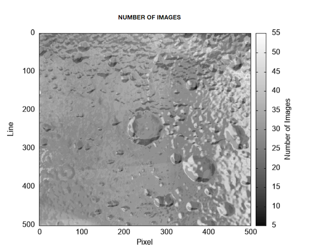
Figure 4. Assessment data for regional DTM in Fig. 1. Shows the SPC internal sigmas for each vertex of the DTM.
As part of SPC processing, each image will be aligned to the topography within 1 pixel. With such an accurate alignment and topography, the photometric data can be calculated on a pixel-to-pixel scale. This data is given in the United State Geological Survey (USGS) Integrate Software for Imagers and Spectrometers (ISIS) cube format. An example of the local emission angle is given in Fig. 5.
Figure 5. Graphical representation of the local emission angle of image N1556123061 for each vertex of the DTM. Black corresponds to 5 deg while white corresponds to 72 deg.
Conclusion:
An SPC global DTM, along with assessment data, of Phoebe (0.3 km/vertex) is currently available from the PDS (Weirich, Gaskell, et al., 2023). Global DTMs and assessment data of Dione (1.6 km/vertex), Mimas (0.6 km/vertex), Rhea (2.2 km/vertex), and Tethys (1.5 km/vertex) are under review at the PDS and will likely be available at the time of this conference. Regional DTMs, assessment data, and photometric data cubes of Dione (~0.4 km/vertex) and Tethys (0.3 to 0.4 km/vertex) are also under review. Similar products for Enceladus and Iapetus are forthcoming.
Though not part of the Saturn system, many other SPC products like these are available, including those for asteroid Bennu, Earth’s Moon (Weirich, Palmer, et al., 2023), Mercury (Weirich, Domingue, et al., 2024), and many other objects. These products are key in the assessment of surface morphology and regolith structure, each providing insight into surface processing of these icy worlds.
References:
Gaskell, R.W., Barnouin-Jha, O.S., Scheeres, et al., (2008). Characterizing and Navigating Small Bodies with Imaging Data. Meteoritics and Planetary Science 43 (September): 1049–61.
Gaskell, R.W., Barnouin, O.S., Daly, M.G., et al., (2023). Stereophotoclinometry on the OSIRIS-REx Mission: Mathematics and Methods. Planetary Science Journal 4: id 63, 15pp.
Lauretta, D. S., Enos, H. L., Polit, A. T., et al., 2021, in Sample Return Missions, ed. A. Longobardo (Amsterdam: Elsevier), 163, doi:10.1016/B978-0-12-818330-4.00008-2
Olds R.D., Miller C.J., Norman, C.D. et al., (2022). The Use of Digital Terrain Models for Natural Feature Tracking at Bennu. Planetary Science Journal 3: id 100, 11pp.
Weirich J.R., Gaskell R., et al., (2023). Phoebe SPC Shape Model and Assessment Products Bundle V1.0. urn:nasa:pds:satellite-phoebe.cassini.shape-models-maps::1.0. NASA Planetary Data System, doi:10.26033/3k3c-5713.
Weirich J.R., Palmer E.E., et al., (2023). Lunar Topography and Photometric Cube Data V1.0. urn:nasa:pds:lunar_lro_lroc_topography_domingue_2023::1.0. NASA Planetary Data System, doi:10.17189/jdpv-z697.
Weirich J.R., Domingue D.L., et al., (2024). Nathair Facula Topography and Photometric Cube Data V1.0. urn:nasa:pds:nathairfacula_messenger_mdis_topography_domingue_2022::1.0. NASA Planetary Data System, doi:10.17189/31AX-FT48.
How to cite: Weirich, J., Domingue, D., Palmer, E., and Gaskell, R.: Digital Terrain Models and Photometric Data of Five Large Saturnian Moons, EPSC-DPS Joint Meeting 2025, Helsinki, Finland, 7–12 Sep 2025, EPSC-DPS2025-115, https://doi.org/10.5194/epsc-dps2025-115, 2025.