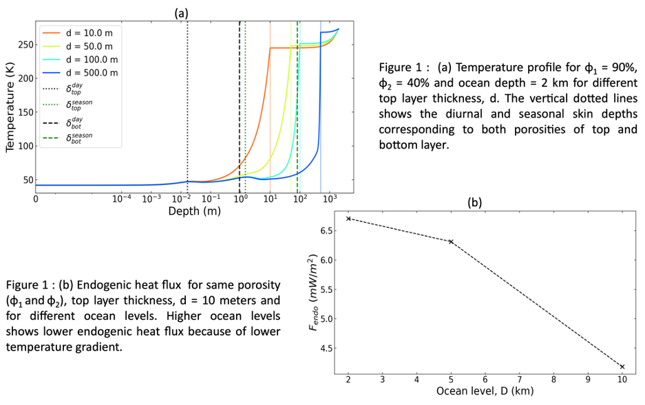
OPS4
Exploring the Saturn system
Conveners:
Carly Howett,
Axel Hagermann
|
Co-conveners:
Georgina Miles,
Günter Kargl,
Katharina Otto,
Stephan Zivithal
Orals TUE-OB2
|
Tue, 09 Sep, 09:30–10:30 (EEST) Room Mars (Veranda 1)
Orals TUE-OB3
|
Tue, 09 Sep, 11:00–12:24 (EEST) Room Mars (Veranda 1)
Orals TUE-OB5
|
Tue, 09 Sep, 15:00–16:00 (EEST) Room Mars (Veranda 1)
Orals TUE-OB6
|
Tue, 09 Sep, 16:30–17:54 (EEST) Room Mars (Veranda 1)
Orals WED-OB5
|
Wed, 10 Sep, 15:00–16:00 (EEST) Room Neptune (rooms 22+23)
Posters TUE-POS
|
Attendance Tue, 09 Sep, 18:00–19:30 (EEST) | Display Tue, 09 Sep, 08:30–19:30 Lämpiö foyer, L10–28
Tue, 09:30
Tue, 11:00
Tue, 15:00
Tue, 16:30
Wed, 15:00
Tue, 18:00

Session assets
Surface
09:30–09:42
|
EPSC-DPS2025-1307
|
ECP
|
On-site presentation
09:42–09:54
|
EPSC-DPS2025-1620
|
On-site presentation
09:54–10:06
|
EPSC-DPS2025-1176
|
ECP
|
On-site presentation
10:06–10:18
|
EPSC-DPS2025-1378
|
ECP
|
On-site presentation
10:18–10:30
|
EPSC-DPS2025-797
|
ECP
|
On-site presentation
Enceladus Interior and Plumes
11:00–11:12
|
EPSC-DPS2025-902
|
On-site presentation
11:12–11:24
|
EPSC-DPS2025-351
|
On-site presentation
11:24–11:36
|
EPSC-DPS2025-2003
|
On-site presentation
11:36–11:48
|
EPSC-DPS2025-829
|
On-site presentation
12:00–12:12
|
EPSC-DPS2025-1885
|
ECP
|
On-site presentation
12:12–12:24
|
EPSC-DPS2025-1124
|
Virtual presentation
Enceladus and Friends
15:00–15:12
|
EPSC-DPS2025-618
|
On-site presentation
15:12–15:24
|
EPSC-DPS2025-330
|
On-site presentation
15:24–15:36
|
EPSC-DPS2025-1638
|
On-site presentation
15:36–15:48
|
EPSC-DPS2025-1800
|
ECP
|
On-site presentation
15:48–16:00
|
EPSC-DPS2025-232
|
ECP
|
On-site presentation
Impact Gardening on Iapetus and Insights into the Evolution of the Extreme Albedo Dichotomy
(withdrawn)
Saturnian Satellites
16:30–16:42
|
EPSC-DPS2025-433
|
ECP
|
On-site presentation


16:42–16:54
|
EPSC-DPS2025-1117
|
On-site presentation
16:54–17:06
|
EPSC-DPS2025-1134
|
ECP
|
On-site presentation
17:06–17:18
|
EPSC-DPS2025-879
|
ECP
|
On-site presentation

17:18–17:30
|
EPSC-DPS2025-115
|
On-site presentation
17:30–17:42
|
EPSC-DPS2025-1187
|
ECP
|
On-site presentation
17:42–17:54
|
EPSC-DPS2025-810
|
On-site presentation
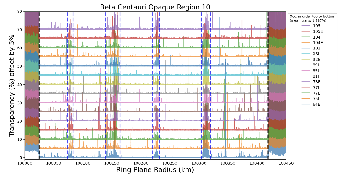
Rings
15:00–15:12
|
EPSC-DPS2025-1572
|
ECP
|
On-site presentation
15:12–15:24
|
EPSC-DPS2025-1052
|
On-site presentation
15:24–15:36
|
EPSC-DPS2025-36
|
On-site presentation

15:36–15:48
|
EPSC-DPS2025-336
|
Virtual presentation


Saturnian Satellites
L10
|
EPSC-DPS2025-1258
|
On-site presentation
L11
|
EPSC-DPS2025-855
|
On-site presentation
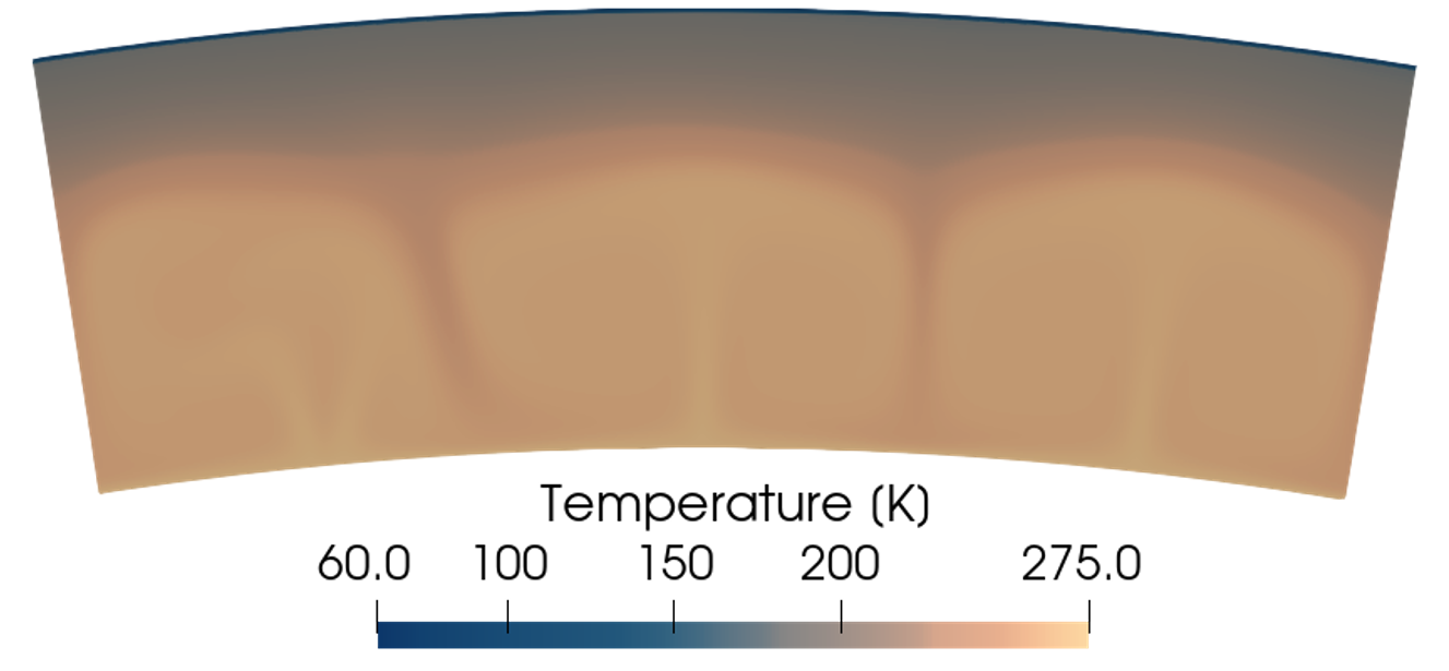
Enceladus Surface
L13
|
EPSC-DPS2025-400
|
On-site presentation
L15
|
EPSC-DPS2025-264
|
ECP
|
On-site presentation
L16
|
EPSC-DPS2025-544
|
On-site presentation
L17
|
EPSC-DPS2025-1574
|
On-site presentation
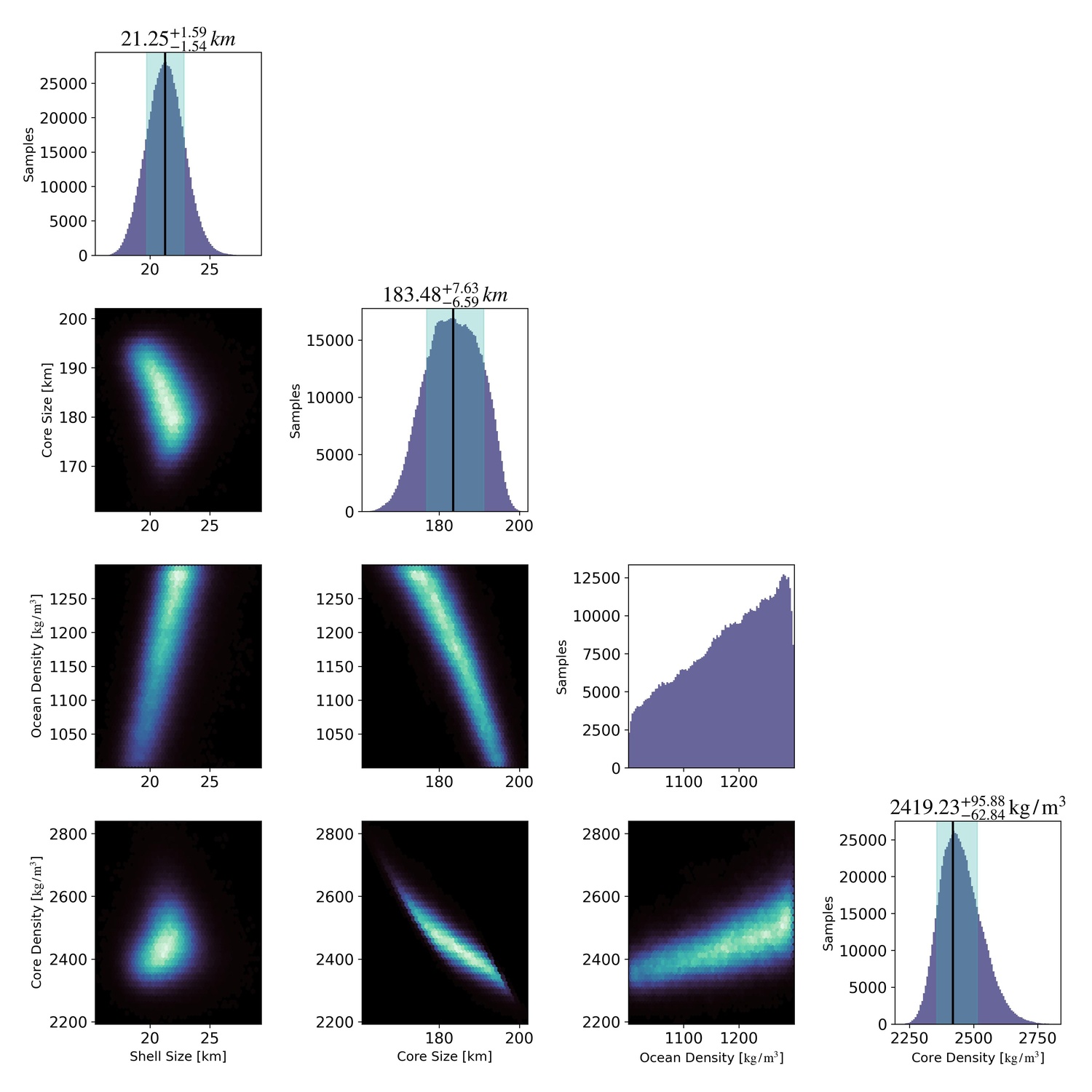
Enceladus Sub-surface and Interior
L18
|
EPSC-DPS2025-2027
|
On-site presentation
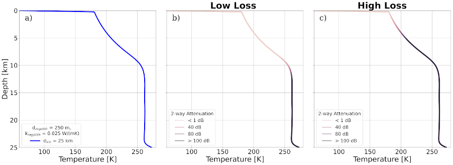
L19
|
EPSC-DPS2025-1531
|
On-site presentation
L20
|
EPSC-DPS2025-1889
|
ECP
|
On-site presentation
Plumes, Induction, Ionospheres and Magnetospheres
L21
|
EPSC-DPS2025-675
|
ECP
|
On-site presentation
Detecting cellular biosignatures from Sphingopyxis alaskensis exposed to Enceladus plume and surface conditions
(withdrawn)
L22
|
EPSC-DPS2025-963
|
On-site presentation
L24
|
EPSC-DPS2025-1196
|
ECP
|
On-site presentation
L25
|
EPSC-DPS2025-1903
|
On-site presentation
Rings
L27
|
EPSC-DPS2025-1769
|
ECP
|
On-site presentation
Evolution of Viscous Overstability in Saturn’s Rings:Insights from Large-Scale N-Body Simulations
(withdrawn after no-show)
L28
|
EPSC-DPS2025-397
|
On-site presentation