ODAA6 | Innovative planetary sciences outreach and dissemination tools

ODAA6

Innovative planetary sciences outreach and dissemination tools
Convener: Gloria Tognon | Co-conveners: Federica Duras, Caterina Boccato, Livia Giacomini, Stephane Le Mouelic, Gwénaël Caravaca
Orals
| Fri, 13 Sep, 08:30–10:00 (CEST)|Room Neptune (Hörsaal D)
Posters
| Attendance Fri, 13 Sep, 10:30–12:00 (CEST) | Display Fri, 13 Sep, 08:30–19:00|Poster area Level 2 – Galerie
Orals |
Fri, 08:30
Fri, 10:30
The rapid evolution of augmented reality, virtual reality, 3D visualisation tools, and digital platforms has revolutionized outreach and dissemination activities in the field of planetary sciences. These innovative technologies offer immersive experiences that allow individuals to explore different environments from unprecedented perspectives. Moreover, they serve as engaging and accessible tools for individuals of all ages, fostering interactive learning experiences and skills development.
In this session, we invite participants to share their experiences and insights into leveraging virtual realities for planetary sciences outreach. Through case studies and examples, we will explore the diverse applications of these technologies, from designing immersive environments to facilitating skills development and training initiatives. Additionally, we will address challenges and opportunities related to intuitiveness, inclusiveness, and the future directions of virtual reality in outreach efforts.

Session assets

Discussion on Discord

Orals: Fri, 13 Sep | Room Neptune (Hörsaal D)

Chairpersons: Sanjeev Gupta, Federica Duras
08:30–08:45
|
EPSC2024-941
|
solicited
|
Virtual presentation
Elizabeth Tasker, Vanessa Moss, Glen Rees, Aidan Hotan, Ronald Ekers, Rika Kobayashi, Emily Kerrison, and Katrina Amos

In the era of climate change concerns, global pandemics, decreasing funding availability and increasing restrictions on travel, the issue of online access to events has become an important topic of discussion. The importance of online access is rarely disputed, with surveys taken during the COVID-19 pandemic demonstrating the substantial increase in diversity across factors such as geographical location, gender, race and sexual orientation. However, the online experience is still usually considered subpar compared to attending a physical venue, and hybrid events that combine both groups often struggle to offer online attendees the same level of experience as the in-person crowd. Part of the answer to this challenge may be found in the utilisation of 3D virtual spaces, which can add a far greater sense of presence to an event, and also offer experiences that are not achievable at a physical venue. 

To explore the possibility for improving interactions between people online, we developed a virtual exhibit focussed on radio astronomy science and technology in the context of the CSIRO ASKAP radio telescope. As with many instruments in planetary science and astronomy, ASKAP consists of cutting-edge technology with a large physical footprint that cannot be transported to events for demonstrations. Moreover, the ASKAP site at Inyarrimanha Ilgari Bundara, the CSIRO Murchison Radio-astronomy Observatory, is located in a remote area with restricted access to protect the telescope from radio interference. Bringing visitors onto the site is therefore rarely possible, presenting a problem in common with remote observatories as to how to share the experiences of scientific investigation.

We demonstrated the virtual exhibit at a booth equipped with two virtual reality (VR) headsets at three primarily in-person scientific conferences: the 2023 Astronomical Society of Australia Annual Science Meeting in Sydney, Australia (ASA2023), the 2023 Asia Pacific Regional International Astronomical Union Meeting in Koriyama, Japan (APRIM2023) and the 2023 Union Radio-Scientifique Internationale General Assembly and Scientific Symposium in Sapporo, Japan (URSI2023). The aim was to showcase the capabilities of a virtual space in communicating science in an impactful and innovative way, and to demonstrate the strength of virtual platforms to connect and meet with people.

The virtual space was hosted on the VR social network platform, “Spatial”. Spatial can be accessed from the Meta Quest VR headset, computers, and smartphones, providing cross-platform access that allows nearly any person with an internet-ready device to join the space. Visitors joining from their computer can access Spatial from the web browser, further lowering the barrier for entry by not requiring a dedicated application to be installed.

From the left: examining the PAF inside the virtual exhibit, stepping into the 360 degree view of the ASKAP site, at the in-person booth at the URSI conference (final image from CAPjournal, in press.)

The virtual exhibit design resembled a museum, with several rooms containing exhibits with accompanying written and audio information. This was a design choice chosen to give a feeling of familiarity to visitors who may not have previously tried virtual reality. Walking through the exhibit, visitors could chat to one another or receive a guided tour from our team. Only one member of our team was physically on-site at the conference venue, with other team members joining from their home country to meet with exhibit visitors. This emphasised the huge advantage of virtual spaces in bringing people easily together, regardless of their physical location. 

Visitors join the exhibit as an avatar, whose location within the virtual space allows for directional audio and audio fall-off. This enables a large group of people to potentially be in the space at the same time and easily hold simultaneous and overlapping conversations as in a physical event hall. Walking through the virtual exhibit moves you naturally between conversations, promoting interactions and networking.

The virtual exhibit included a number of displays that would either be very difficult or not possible in a physical exhibition space. These included animated models of the ASKAP radio antenna and a full-scale model of the Phased Array Feed (PAF) receiver that increases the antenna’s field of view by a factor of 36. Upon approaching the PAF, the receiver expands outwards to reveal the internal components, and a holographic animation of a CSIRO staff member appears next to the model and describes the now visible parts. Visitors could also step inside a 360-degree view of the ASKAP site, providing a view of the antennas as if they were a scientist visiting on location. 

This year, we have extended on the initial project, developing an immersive multi-room virtual venue for online and hybrid conference applications. The venue includes galleries for displaying posters, interaction spaces, and exhibit halls, designed around providing familiar and personal experiences that will facilitate effective networking. The virtual venue is planned for use at three conferences to be held in 2024, including the Astronomical Society of Australia Annual Science Meeting and the International Astronomical Union General Assembly, and is intended to enable online participants, via a greater sense of presence, to engage more organically with meeting content and other attendees.

This contribution will present an overview of our experience with the design, construction and demonstration of the virtual exhibits and spaces, with an emphasis on the current technological readiness of virtual reality approaches to augment interactions such as those that take place in conferences and exhibit halls. It is our goal to emphasise that the creation of this kind of virtual experience is not limited to experts in technology, but can be realised similarly with a modest amount of technical expertise combined with readily available hardware. The use of VR for online events has the potential to bring an audience together to share experiences that have the social strengths of a physical location, but provide sights and opportunities that go “beyond being there”. 

How to cite: Tasker, E., Moss, V., Rees, G., Hotan, A., Ekers, R., Kobayashi, R., Kerrison, E., and Amos, K.: Virtual spaces for real connections, Europlanet Science Congress 2024, Berlin, Germany, 8–13 Sep 2024, EPSC2024-941, https://doi.org/10.5194/epsc2024-941, 2024.

08:45–08:55
|
EPSC2024-1137
|
Virtual presentation
Thibaut Roger

The spectroscopy table is an “all-in-one” outreach demonstrator that enable you to engage in an interactive and playful way with students or the general public, to demonstrate several concepts of spectroscopy, focusing on its use for planetary sciences. Its modular and open-source design allows you to quickly reconfigure it to explore a vast array of science concepts more in line with the science topics explored by your own institute.

With bright LEDs modeling the visible spectrum, it attracts spectators from far away in crowded events. This device is aimed to be used both as a 5-minute entry point into the wonderful world of spectroscopy for the general public, or to be expended for lectures or for the more curious publics into a full 45-minute experience serving as an effective crash-course exploring the many subtle way to use spectroscopy.

Currently in its second prototype iteration – and already used in events which enable to improve design based on feedbacks – the end goal of this project is to be fully available in open-source once completed (summer 2024). This will allow other institutes and scientists to replicate it and adapt it to their own needs. The table can be easily assembled with off-the-shelves components and its electronics is based around the equally open-source Arduino boards. In its default mode, individually addressable RGB LEDs strips have been calibrated to accurately represent the visible spectrum, while a series of switches enable to select chemical elements (atoms or molecules) and see their effects on the spectrum (the current 8 elements have been carefully selected for their relevance to the science cases explored by my institute, but can be adapted as wishes). More buttons and rotary elements allow to change the parameters of what you are representing such as the mass and period of a planet around a star, and to visualise thanks to the LEDs, their (exaggerated) effect on a spectrum (i.e., radial velocity).

By demonstrating them or by triggering discussions for further explanations, the current model tackles several key concepts related to spectroscopy and astrophysics, focusing on exoplanets as it is developed in a planetary science institute. This includes: emission and absorption spectroscopy by atoms or molecules, electrons orbits, stellar characterisation, Doppler-Fizeau effect, radial velocity of both exoplanets or binary stars, stellar typing, transit method for exoplanets detection and transit spectroscopy for atmospheric characterisation, eclipsing binaries, stellar rotation speed and the Rossiter-McLaughlin effect. The commands being built symmetrically, you can even turn the table in a playful “mastermind”-like spectroscopy game where participants have to figure out the chemical components hidden in a spectrum and test their understanding of the demonstrated scientific concepts.

Design in a similar-fashion, my already-completed project nicknamed the Trappist-1 lightshow has all building instructions, including the Arduino-code to run it, available on my personal website (see http://thibaut-roger.com/Wordpress/trappist-1-lightshow/). This device again enables a 5-minute surface scratch or a 45-minute deep-dive on several astrophysical topics. With it, you can explore the concepts of exoplanets, transit method, habitable zone, resonances, tidal locking, M-dwarf and their properties, stellar eruption and space weather, as well as astrobiology.

Beyond the specific example of the spectroscopy table (and of the Trappist-1 lightshow), I will also discuss the pros and cons of open-source/off the shelves electronic components, and tell the story how proprietary technology on the contrary proved a problem to maintain another demonstrator developed at my institute. 


This project has received support from the Swiss Society for Astrophysics and Astronomy and from the National Centre of Competence in Research (NCCR) PlanetS. The National Centres of Competence in Research are a funding instrument of the Swiss National Science Foundation. 

How to cite: Roger, T.: The spectroscopy table and the use of open-source electronics for outreach demonstrators., Europlanet Science Congress 2024, Berlin, Germany, 8–13 Sep 2024, EPSC2024-1137, https://doi.org/10.5194/epsc2024-1137, 2024.

08:55–09:10
|
EPSC2024-520
|
solicited
|
On-site presentation
Livia Giacomini, Francesco Aloisi, Antonella Corleone, Edward Gomez, Giulio Mazzolo, and Gwen Sanderson

AstroEDU is the open-access platform supported by IAU (International Astronomical Union) that offers a monthly opportunity to discover new, peer-reviewed, high-quality educational activities related to Astronomy. Our planet and its space in the Universe is indeed a great topic to fascinate young generations and to involve them in the general process of learning and growing up, being easily related to many other STEM and nonSTEM disciplines such as math, physics, history, philosophy, art and many others

Today AstroEDU is the only educational platform that mixes two different approaches: the peer-review method of publication in scientific literature, and the bottom-up approach of a collaborative network of teachers and educators.
The target audience of AstroEDU is a growing community of educators, students, parents and researchers involved in education. In the last years, AstroEDU has also experimented with new technologies in order to enlarge this community and make it as worldwide and inclusive as possible. 

In this presentation we will unveil the new AstroEDU platform and its editorial approach to fit this multilingual and diverse community. We will provide an overview of the innovative activities that have been published to date, asking ourselves to what limit they can be considered “open educational resources”, accessible and usable from all around the world.

We will also focus on how new technologies such as A.I. can be used to improve the user experience, introducing A.A.A., the AstroEDU Artificial Assistant, currently under development. 

How to cite: Giacomini, L., Aloisi, F., Corleone, A., Gomez, E., Mazzolo, G., and Sanderson, G.: AstroEDU, the innovative platform to learn (with) astronomy, Europlanet Science Congress 2024, Berlin, Germany, 8–13 Sep 2024, EPSC2024-520, https://doi.org/10.5194/epsc2024-520, 2024.

09:10–09:15
09:15–09:25
|
EPSC2024-978
|
On-site presentation
Federica Duras, Livia Giacomini, Caterina Boccato, Giulia Mantovani, Federico Di Giacomo, and Emanuele Scalise

We will present the behind the scenes of an expansive astrophysics exhibition, "Time Machines", hosted at the prestigious Palazzo Esposizioni in Rome from November 2023 to March 2024.

This was the first large exhibition conceived and realised by INAF, the Italian National Institute for Astrophysics. It offered visitors an extraordinary journey through space and time, all the way to the far reaches of the known Universe, until the dawn of cosmic history, with the help of telescopes, the “time machines” of astronomers and astrophysicists. With a pop style and eighties flair, the exhibition exploited the light travel time – the farther astronomical objects we observe, the further we see back in time – to explore planets, stars and galaxies along an itinerary that is both physical and conceptual. 

The exhibition was fully bilingual (Italian and English) and included dedicated panels specially designed for primary school children. 

The creation of the exhibition spanned almost two years, beginning with a core team that included astrophysicists to select the most relevant content, science communicators to make that content accessible, experienced curators of scientific exhibitions and museums, communication experts, and specialists in astronomy education and inclusive practices.

‘Time Machines’ integrated various interactive tools to tell the story of modern astrophysics, offering the public unique opportunities for active involvement and discovery. One example is a touch table conceived and designed to offer adults and children the individual and/or collaborative opportunity to touch the Solar System by accessing, visualising and manipulating a series of information boards. Through this exhibit, users could select their favourite planet, explore its characteristics and immerse themselves in a wide range of virtual and multimedia content related to the Solar System. It is also a very useful tool from a didactic point of view, as it goes beyond traditional pen-and-paper teaching methods and facilitates more effective learning for the individual and the class group, creating a playful and stimulating environment. 

Another example is the virtual tour of the INAF's main observatories. Wearing the virtual reality visor, the viewer is immersed in an immersive and high-impact 360° experience, exploring, while having fun, the key locations of Italian astrophysical research and the main celestial sources studied and observed in these places. 

Great emphasis was placed on inclusivity, from the sensory planetarium designed for blind people to sound exhibits and sign language guides for deaf people.

All this has led to a product that appeals to non-specialist people, capturing also those who are not usually interested in science and manages to create a community around such a complex object as an exhibition.

How to cite: Duras, F., Giacomini, L., Boccato, C., Mantovani, G., Di Giacomo, F., and Scalise, E.: An innovative journey through time and space: the 'Time Machines' exhibition, Europlanet Science Congress 2024, Berlin, Germany, 8–13 Sep 2024, EPSC2024-978, https://doi.org/10.5194/epsc2024-978, 2024.

09:25–09:35
|
EPSC2024-958
|
ECP
|
On-site presentation
Nicole Costa, Gloria Tognon, Silvia Bertoli, Francesca Ferri, and Matteo Massironi

For the second consecutive year, the University of Padua hosted a scientific communication initiative known as Science4All, which aims to convey scientific concepts in an engaging and accessible manner.

Science4All comprises two primary outreach events. The first occurs at the end of September, featuring a full-day program where young researchers and university staff organize workshops, scientific cafés, games, quizzes, and shows accessible to the public. Various stands are situated across Padua's historic center, arranged along thematic paths, while museums and university departments also offer guided tours. The second outreach event targets school groups and this year took place during the last two weeks of November. Depending on the chosen activity, students either visit university facilities or participate in dedicated workshops or seminars led by university staff at their own schools.

The Center of Studies and Activities for Space (CISAS) "Giuseppe Colombo," as an interdisciplinary center operating across multiple departments, has committed to contributing to this initiative by offering various activities. Among these, CISAS supported the organization of workshops focused on planetary geology. Given the resurgence of interest in lunar exploration and colonization, coupled with the achievements of past (e.g., Rosetta) and ongoing (e.g., Perseverance) space missions, the field of planetary geology captivates audiences with its discoveries and practical applications.

In this context, we provide an overview of the activities dedicated to the promotion of planetary geology.

An all-day long workshop dedicated to all citizens needs to find a simple, funny and speedy way to release its take-home messages. At the same time, the workshop activities need to be accessible and engaging for all ages and, why not, also captivating. Keeping this in mind, we organized a game session of Planetary Bingo. During the game, each participant was provided with a bingo card and, in order to place a marker, had to answer a series of questions on small curiosities about the geology of planetary bodies in our Solar System and beyond (e.g. Mars, Earth, Jupiter, comets). The explanation of each answer was assisted by the presentation of an explanatory image displayed on a large screen. Participants were granted the possibility to join the game anytime so that everyone could win and be rewarded with a “planetary” prize.

For the educational activity for schools, instead, we organized a full-on immersion in planetary geology dedicated to students from 5th-grade elementary school to 3rd-grade middle school. The activity was structured with an introductory part in the form of a seminar followed by a workshop in which the students had the possibility to walk on Mars and the Moon in a virtual reality (VR) environment. More in detail, during our geo-planetary seminars we held an introduction showcasing the most interesting and fascinating facts in terms of geology and exploration for the Moon, Mars and Mercury. We focused also on the training undertaken by astronauts to be able to analyze, sample and report on a planetary surface, as an expert geologist would do, through the study of terrestrial analogs. Just like the astronauts, the students were then able to touch and try to recognize which (analog) rocks might be found on Mars, Mercury or the Moon. To conclude our activity, we accompanied the students on a virtual walk on the river delta deposits within the Jezero crater (Mars), the lacustrine deposits within the Crommelin crater (Mars), the central peak of the Copernicus crater, and the site of the Extravehicular Activity 3 held during the Apollo 17 mission. Simultaneously to the VR experience, we organized a parallel session of planetary mapping dedicated, in case of necessity, to students with cognitive or learning disorders, or unable to use the VR.

Overall, the planetary geology activities offered during Science4All proved to be highly effective in engaging participants in scientific exploration. The activities were well-suited to the audience's age and level of knowledge, ensuring that even fundamental concepts in astronomy and geology were effectively communicated and the use of various didactic tools (e.g., images, presentations, rocks, virtual environments) received positive feedback for their intuitive nature and comprehensive coverage of the subject matter.

Acknowledgements: We acknowledge funding and support from the Società Italiana Scienze Planetarie – Angioletta Coradini (SISP-AC) and from the Centro di Ateneo di Studi e Attività per lo Spazio «Giuseppe Colombo» (CISAS) of the University of Padua.

How to cite: Costa, N., Tognon, G., Bertoli, S., Ferri, F., and Massironi, M.: From Earth to the Moon and Mars: a virtual walk on the planetary surfaces. A CISAS-UNIPD outreach activity in planetary geology., Europlanet Science Congress 2024, Berlin, Germany, 8–13 Sep 2024, EPSC2024-958, https://doi.org/10.5194/epsc2024-958, 2024.

09:35–09:45
|
EPSC2024-739
|
ECP
|
Virtual presentation
Gwénaël Caravaca, Sylvestre Maurice, Jérémie Lasue, Aude Lesty, Xavier Penot, Simon Pujol, and Florence Seroussi

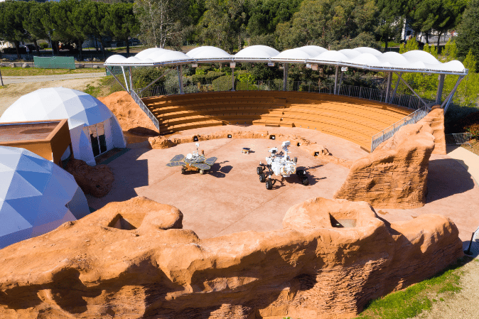
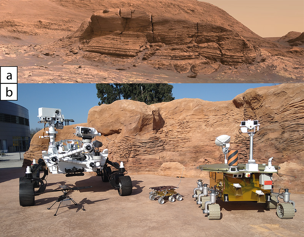
The Mars Yard has been created in 2022 at the Cité de l’espace (Toulouse) to host the live animation “The Rovers take the stage” (“Les rovers entrent en scène”). It is built as a ~900 m² arena able to accommodate ~250 persons at a time (Fig. 1). The idea behind that set was to propose an immersive environment faithfully replicating a Martian geological outcrop. To that end, the Mont Mercou outcrop explored by the NASA rover Curiosity in Gale crater has been chosen. Mont Mercou is a ~7m-high stratified dune formed within an ancient river. Studied by Curiosity in 2021, it features one of the most scenic environment of the mission, and was therefore a suitable model for the Mars Yard (Fig. 2a).
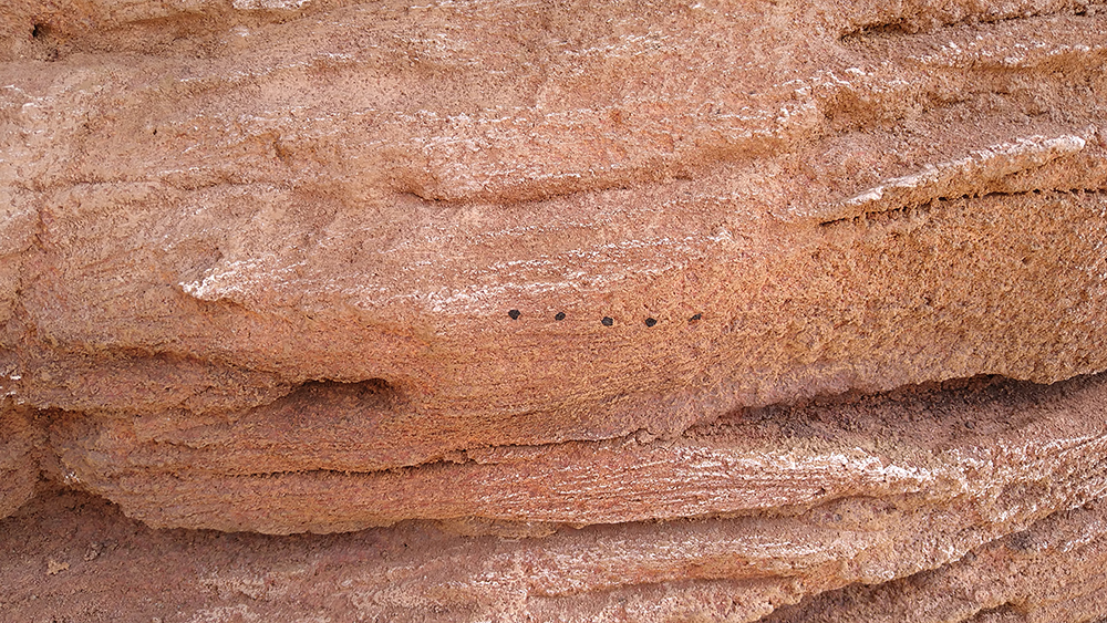
When entering the Mars Yard, the visitors enter a scene built as a “mini-crater”, to provide an instantaneous sense of immersion with the Martian set as their immediate landscape. They are facing two walls sculpted and colored to replicate the size, shape and structures typical of the Mont Mercou outcrop with a variety of smooth and cross-stratified series (Figs. 2 and 3). Several small details such as exaggerated renditions of LIBS laser shots have been placed to further this feeling (Fig. 3). On top of the rocky setting, a giant outdoor screen has been installed to provide visual support to the exhibition.
As part of the animation, the visitors get to see four full scale replicas of Martian robotic explorers (Fig. 2b). Two of them are animatronics: the NASA’s Mars 2020 Perseverance rover, and the CNSA’s Tianwen-1 Zhurong. Both rovers are fully functional and perform movements and simulations of their science activities (e.g., wheel motion, LIBS laser shot, sampling). Two additional replicas are also present: the helicopter Ingenuity and the pioneer rover Sojourner. All of these replicas are presented and/or operated within the Martian setting offered by the Mars Yard as if they actually were on Mars.
These rover operations are taking place as part of a ~40 minutes-long live animation presented by a duo of scientific guides. During this presentation, the visitors are given general but visual information about Mars, its geologic robotic exploration, and therefore the mission of the rovers in front of them. They are also presented with activities like feeling the Martian wind, of the effect of SuperCam’s laser on rocks, using a low-powered laser and a balloon. Recent news from the missions are also given since the animation is regularly updated with the latest notable material. This includes latest images sent back to Earth by the rovers that are displayed on the giant screen.
This exhibition and animation is a joint effort between Cité de l’espace, French Space Agency CNES and the IRAP laboratory in Toulouse.

Figure 1: General aerial view of the Mars Yard (© Cité de l’espace), with full scale replicas of the Zhurong, Sojourner and Perseverance rovers, before installing a giant outdoor screen above the rocky setting.

Figure 2: a) General view of the Mont Mercou outcrop on Mars, that was the main inspiration for the setting of the Mars Yard. This ~7m-high scenic outcrop displays a variety of cm- to dm-scale cross-stratification formed in a fluvial setting (NASA/JPL-Caltech/MSSS/Thomas Appéré). b) General view of the Mars Yard setting, with full-scale replicas of Perseverance, Sojourner and Zhurong rovers, and Ingenuity helicopter (© Cité de l’espace).

Figure 3: Details of the structures and LIBS laser shots markings reproduced on the Martian setting (© Cité de l’espace).

How to cite: Caravaca, G., Maurice, S., Lasue, J., Lesty, A., Penot, X., Pujol, S., and Seroussi, F.: The Rovers take the stage!: an immersive live experience of Mars exploration, Europlanet Science Congress 2024, Berlin, Germany, 8–13 Sep 2024, EPSC2024-739, https://doi.org/10.5194/epsc2024-739, 2024.

09:45–09:55
|
EPSC2024-1265
|
On-site presentation
François Civet, Lionel Clarke, David Vandergucht, Guillaume Bertrand, Kevin Costard, and Charlotte Clochez

VRExplorer

This software is an immersive and collaborative tool allowing visualization and analysis of planetary terrains. This tool has been developed for education of the new generation of geoscientists to improve the comprehension of planetary terrains. After several months of deployment, VRExplorer already shows a huge potential both for students and researchers. The software is based on a cloud platform on which users can upload their dataset, using standard formats used by the geoscience community: digital terrain models, meshes, and point clouds. It creates the virtual scenes automatically and share the tiles to remote users in real time up to the native resolution of the dataset. Connecting to the application, users can see and talk to each other, they can navigate over the terrains stored on the server using both virtual reality headsets and classical computers.

A cloud-based storage

The web-platform allows users to upload GeoTIFs satellite images to create regional context of areas of interest. It reads the metadata of images providing an absolute geographic reference for each virtual scene based on the projection information of inputs. Virtual terrains are then processed using both topographical (DTM) and texture (orthoimages). Users can also upload meshes in 3DTiles format (Standard from Open Geospatial consortium). This specific file format enables to store and share massive meshes preserving the initial resolution of the data and the geographic reference.
The result is a fusion of massive datasets shared to multiple users.

A tool for teaching geosciences

VRExplorer is already used in several universities and aims at becoming a reference for virtual pedagogy on unreachable terrains.
For teachers, this tool is used to:
- Easily share and explore geodata-rich scenes of various kind,
- Create courses and assessments into the virtual scene,
- Gather records of user experiences, measurements created by users, and answers to course sessions for post course analysis.
For students, it’s a ludo-educative tool providing emotional experiences which are well-known to be a multiplier in the process of understanding and memorization.


How to cite: Civet, F., Clarke, L., Vandergucht, D., Bertrand, G., Costard, K., and Clochez, C.: VRExplorer an immersive and collaborative tool to multiply field trip experiences, Europlanet Science Congress 2024, Berlin, Germany, 8–13 Sep 2024, EPSC2024-1265, https://doi.org/10.5194/epsc2024-1265, 2024.

09:55–10:00

Posters: Fri, 13 Sep, 10:30–12:00 | Poster area Level 2 – Galerie

Display time: Fri, 13 Sep, 08:30–Fri, 13 Sep, 19:00
Chairpersons: Sanjeev Gupta, Federica Duras
P62
|
EPSC2024-432
|
Virtual presentation
Stéphane Le Mouélic, Gwénaël Caravaca, Mélanie Guenneguez, Nicolas Mangold, and Benoît Seignovert

When coupled with 3D techniques such as photogrammetry or stereoscopy, Virtual and Augmented reality provide new means to investigate planetary surfaces [1]. These immersive rendering systems can be used for either outreach, education, or scientific investigations. We have tested several use cases including orbital flybys derived from high-resolution images and DEMs, or in situ investigations either by humans (Apollo sites) or rovers.

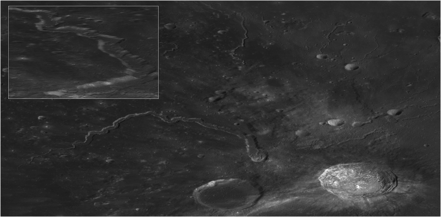
Figure 1 displays an example of a VR scene that we have created with the Unity3D environment in order to fly over the Aristarchus Plateau on the Moon, using mainly Kaguya orbital imagery as input. The scene can be explored on a PC, or using a standalone wireless headset such as the Oculus Quest 2 or 3. The immersive rendering allows a close investigation of the crater morphologies (impact melt on the floor and ejecta, landslides on the crater wall, …) and of the multiple sinuous channels such as the Schröeter Valley, using a free flyover mode at several scales, from global to local.

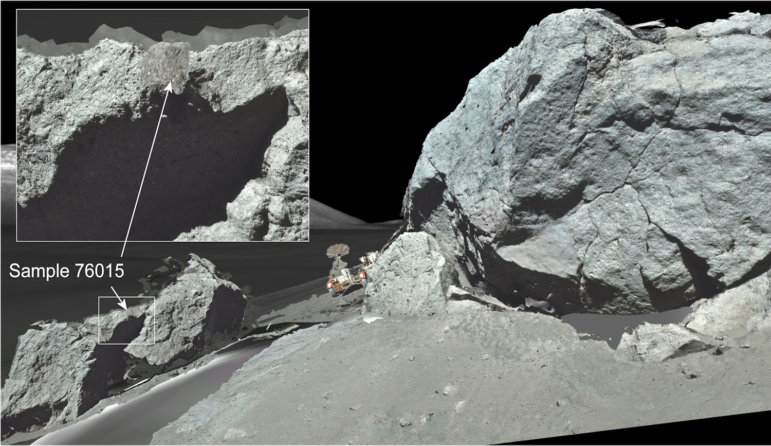
We have also carried out a detailed investigation of in situ imagery acquired by human or robotic missions. In particular, we have recreated the station 6 geologic waypoint of the Apollo 17 mission, using photogrammetry techniques applied both to Apollo photographs of lunar boulders and to laboratory photographs of lunar rock samples retrieved from these boulders [2, 3]. 3D models of three rock samples have been replaced at their original position on their parent boulders in a Virtual Reality simulation, giving their exact context. They can be freely manipulated in a collaborative SteamVR environment (Figure 2), accessible from this address:  https://steamcommunity.com/sharedfiles/filedetails/?id=2676700770). This can be useful for example to investigate rock alteration surfaces due to space weathering effects. More evolved analysis such as paleomagnetic studies could even be envisaged with such a photogrammetric approach allowing the precise localization/orientation of the samples.     

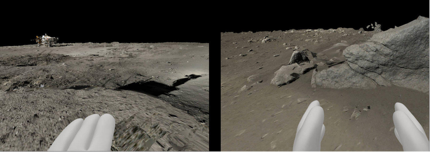
Finally, the same photogrammetry technique has been tentatively applied on images of the Chinese Chang’e 3 lunar rover to setup another VR simulation, which allows to walk from the landing station up to the “Dragon rock” area (Figure 3). In this case, the 3D reconstruction is made challenging by the fact that the conditions of illumination have significantly changed during the image acquisitions. Indeed, two 360 degrees panoramas were taken in 22-23 and 24 December 2013 and two others in 12-13 January 2014 with an opposite sun angle compared to the first series, creating very different shadows. The merging of the two sets needed to increase the surface coverage therefore locally produce residual artifacts.   

Both in the case of a flyover or an in situ ground investigations, one of the main advantages of using a VR system is to facilitate the data handling, to get a better sense of the scales and relationships between different units, and to freely select any point of view to investigate geomorphologic features of interest, from global to local scales. Several rendering and data integration systems can be used, such as simple web-based platform such as Sketchfab (i.e. https://sketchfab.com/LPG-3D), the steamVR workshop, or dedicated systems based on game engines such as VRExplorer.

References : [1] Caravaca et al., Planet. Space Sci, 182, 104808, 2020. [2] Le Mouélic et al., Remote Sensing, 12 (11), 2020. [3] Le Mouélic et al., Planet. Space Sci., 240,105813,, 2024

Figure 1: The Aristarchus Plateau as imaged by Kaguya and integrated into a Virtual Reality simulation allowing to freely fly over the landscape.  

Figure 2: Virtual Reality simulation of the Apollo 17 Station 6 boulders and rock samples on SteamVR [3].


Figure 3: Virtual Reality simulation of the Chang’e 3 landing site derived from a photogrammetric analysis of rover images. The users can freely walk from the landing platform (left) up to the “Dragon Rock” (right). A strong opposition effect (brightening) is seen around the shadow of the rover mast (Left).

How to cite: Le Mouélic, S., Caravaca, G., Guenneguez, M., Mangold, N., and Seignovert, B.: Virtual Reality to investigate the surface of the Moon: From the Aristarchus Plateau to the Apollo 17 and Chang’e 3 landing sites, Europlanet Science Congress 2024, Berlin, Germany, 8–13 Sep 2024, EPSC2024-432, https://doi.org/10.5194/epsc2024-432, 2024.

P63
|
EPSC2024-814
|
On-site presentation
Sanjeev Gupta, Serban Ovidiu, Brython Caley-Davies, Robert Barnes, and Alexander Jones

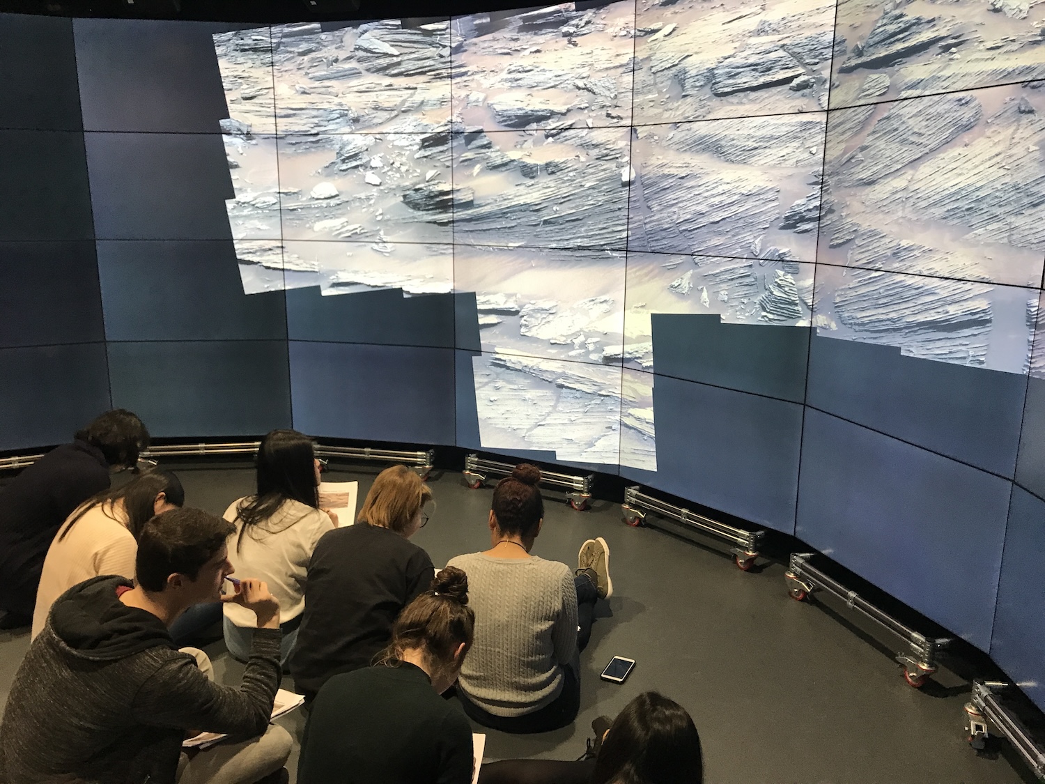
Recent orbital and rover images of the surface of Mars provide exceptional high-resolution views of the martian landscapes and its surface geology. These extensive datasets provide remarkable resources to teach undergraduate and graduate students about geological concepts and planetary geology. However, despite the panoramic aspect of many of these image datasets and their often very high resolution, the data are generally studied by students on small laptop computer screens or low-resolution projection systems in a classroom setting. This limits the ability to easily explore and interrogate the martian surface. Here, we describe how we use a large visualisation system at Imperial College to enhance student learning about the modern surface of Mars and its ancient past through group-based exploration of geological data returned by probes. Essentially, we take students on ‘fieldtrips’ to Mars.

Imperial College Data Observatory

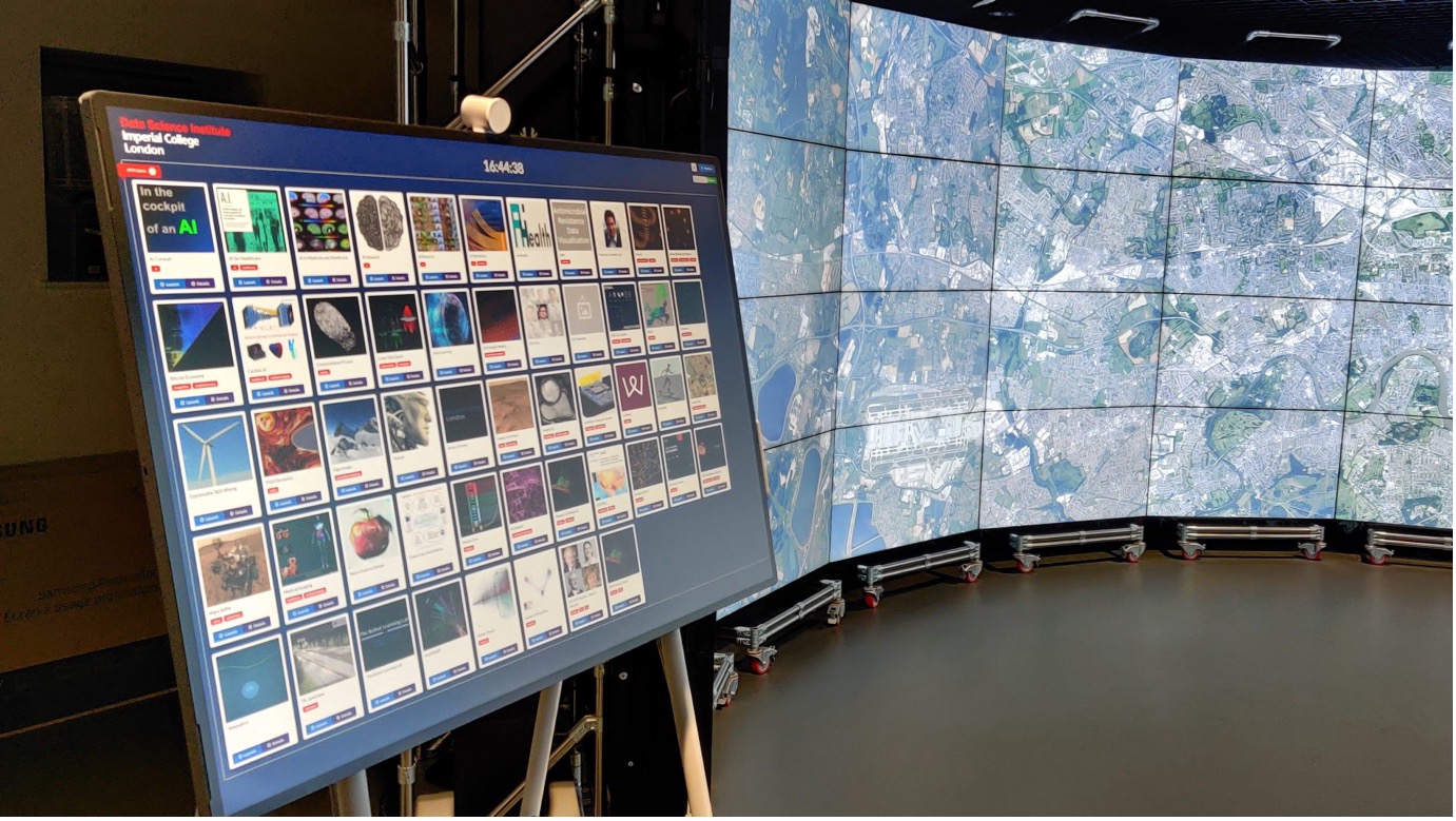
Imperial College's Data Science Institute houses a remarkable facility, the Data Observatory (DO). This expansive, semi-circular display, spanning approximately ~ 6 m in width and extending from the floor to the ceiling, offers a truly immersive experience [https://www.imperial.ac.uk/data-science/facilities/data-observatory/]. With 313 degrees of visual coverage, it boasts over 132 million pixels provided by 64 fine-bezel, full HD screens. Figure 1 showcases the Data Observatory, featuring a control panel that empowers the presenter to select the desired demonstration, with a rendering of the London map on half of the visual canvas.

Scalable-resolution display environments, including immersive data observatories, are evolving into potent tools for joint data exploration and decision-making. However, effective operation of these platforms depends heavily on specialized middleware. Existing solutions often fall short in this domain, particularly in supporting scalable data visualization rendering effectively. To address these challenges, the Digital Output team developed the Open Visualization Environment (OVE), an innovative, modular, open-source middleware designed to overcome these limitations and enable groundbreaking advancements in large-scale data visualization.

Leveraging OVE as the core rendering engine, we have introduced two instrumental tools to enhance user interaction and streamline workflows. The first tool, next-ove, offers a visual editor that simplifies the design and implementation of large-scale demonstrations, facilitating efficient management of complex projects. The second tool, ove-jupyter, is a Jupyter Notebook extension that allows easy visualization of notebook cell outputs on a Data Observatory with just a couple of lines of configuration code, integrating seamlessly into users' existing workflows and significantly boosting the visualization capabilities within these advanced display environments.

A field- trip to Mars in the Imperial College Data Observatory

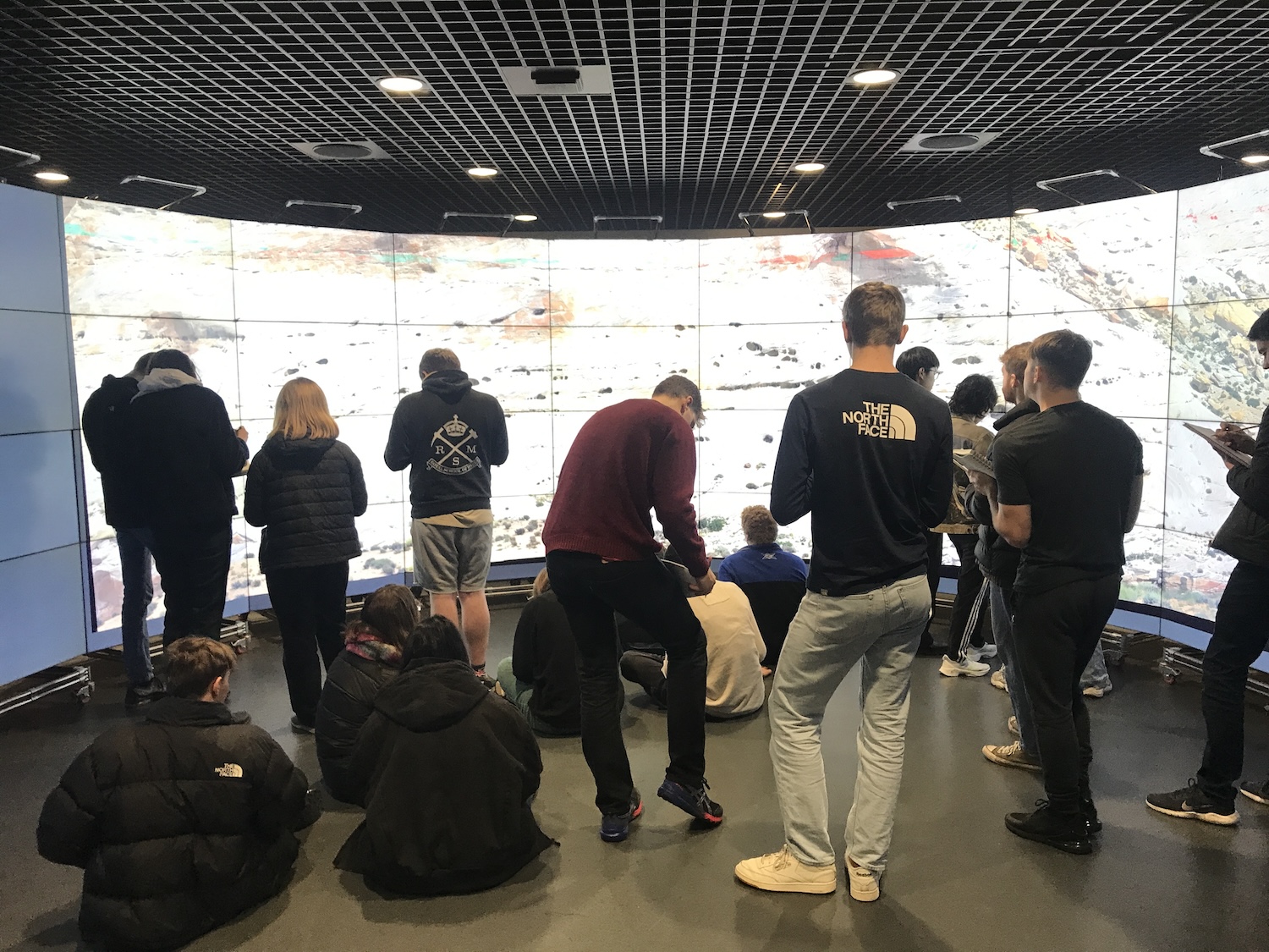
Whilst many planetary educational strategies highlight Virtual Reality and Augmented Reality as learning tools these are commonly solo activities. The very large-scale display system in the Imperial Data Observatory enables a combination of self-exploration and guided learning for up to ~20-25 students in a collective environment – much like a real-world fieldtrip on Earth. OVE enables rapid processing and display of very large image datasets in the Data Observatory. Typically, a learning session will involve a preliminary lecture introducing a planetary topic or case study, for example aeolian processes on Mars. This provides essential background enabling common entry to all students to the topic we will explore in the Data Observatory session. Subsequently we make the ‘trip’ on campus to the Observatory with students bringing their field notebooks and rucksacks much as they would on a real fieldtrip. During an educational session we typically explore 4-5 individual image mosaics depending on the learning activity and its goals. Students are then ‘allowed’ to explore the image of a geomorphic feature, for example a barchan dune or a sedimentary rock outcrop by themselves (Figure 2). They are strongly encouraged to explore and discuss jointly with their peers if they so wish. Typically no point-by-point task list or worksheet is provided. On questioning students have explained how they really appreciate the chance to look for themselves with no detailed instructor guidance on tasks. Typically, we allow 15-20 minutes per image (depending on image/topic complexity) for students to explore, make annotated sketches in their field notebooks (Figure 3) and draw interpretations and conclusions from their observations, just as they would in the field. We then discuss our findings in a group setting with students offering their observations, and as a group we develop and discuss interpretations and limitations. 

A big advantage of the very large scale of the Data Observatory display system is that rather than zooming in and out of an image as you would do on a computer screen, , the large display allows students to ‘walk around’ the martian rock outcrop, looking up close at details and being able to step back to get the big picture. This ‘big picture’ context is often lost when interrogating the up-close details of a martian outcrop on a smaller screen. Whilst exploring a 2-D panorama is relatively simple compared to being able to view outcrops in 3-D in VR and AR systems, the simplicity of focussing and analysing a single panorama and collaborative nature of the learning activity, enhances the student experience. Significant value can be attached to group discussion with their peers.


In summary, ‘field excursions’ to the Data Observatory at Imperial enable the possibility of partially simulating the field experience in a remote place and in the case of Mars not currently accessible to humans. Here, we are able to navigate from the orbital scale down to the rover-derived outcrop scale enabling students to contextualise their observations. Virtual field trips to the Observatory not only provide a new extra-terrestrial experience for students, but can also act as a ‘primer’ for fieldwork on Earth. Virtual ‘fieldwork’ enables initial development of observational and data capture skills allowing valuable time in the field to be spent on more advanced learning activities. Finally, the DO offers accessibility for students who are unable to readily participate in fieldwork, and provides students the opportunity to gain a sense of actual fieldwork – without the rain!

Figure 1 Overview of the Data Observatory

Figure 2 Students sketching sedimnentary features of rock outcrops on Earth.

Figure 3 Students conducting fieldwork on martian aeolian outcrops.
 

How to cite: Gupta, S., Ovidiu, S., Caley-Davies, B., Barnes, R., and Jones, A.: Fieldwork teaching on Mars using a Large-Scale Visualisation System, Europlanet Science Congress 2024, Berlin, Germany, 8–13 Sep 2024, EPSC2024-814, https://doi.org/10.5194/epsc2024-814, 2024.

P64
|
EPSC2024-1164
|
On-site presentation
Anita Heward, Peter Grindrod, Sara Russell, and Aimee Smith

In the summer of 2024, the Natural History Museum (NHM) and partner institutions involved in the Europlanet 2024 RI project are launching an exciting, interactive virtual exhibit about Mars Sample Return.

The exhibit uses Augmented Reality (AR) to bring the NHM martian meteorite collection and the surface of the planet to life. The design of the exhibit is optimised for mobile phones, where AR can be used to maximum effect, as well as tablets and laptops. An underlying theme is an emphasis on how Mars Sample Return relies on a diverse team of scientists and engineers, and on extensive international cooperation.

The information is aimed at the interested public, including adults and teenagers, and is multi-layered to include links to more detailed information. 

The landing page from which the 'virtual galleries' are accessed includes 3D models that can be explored through AR and/or on screen. The main sections include:

  • The Red Planet
  • Martian Meteorites
  • Mars Sample Return Campaign
  • Exploring Mars and Jezero Crater
  • Showcase Research

Europlanet 2024 RI has received funding from the European Union's Horizon 2020 research and innovation programme under grant agreement No 871149.

How to cite: Heward, A., Grindrod, P., Russell, S., and Smith, A.: Bringing Mars Back to Earth – A Virtual Exhibition, Europlanet Science Congress 2024, Berlin, Germany, 8–13 Sep 2024, EPSC2024-1164, https://doi.org/10.5194/epsc2024-1164, 2024.

P65
|
EPSC2024-1317
|
ECP
|
On-site presentation
|
Beatrice Baschetti, Silvia Bertoli, Nicole Costa, Simone Molinari, Jacopo Nava, and Manuel Rigo

Introduction

We present here an interactive outreach activity for schools which can be adapted for students ranging from elementary school to high school. The objective is to divulge information about the origin of the Solar System and its planets, with a special focus on meteorites, impact processes and mapping on the surface of Mars and the Moon. The activity is structured in two parts which are detailed below. 

Meteorites and the origin of the Solar System 

In this activity the students had to get into the role of a planetary scientist, learning how to recognize and characterize a meteorite from the macroscopic and microscopic point of view. After a short presentation the activity starts with the macroscopic characterization. We provided the students with two boxes in which meteorites were mixed with terrestrial rocks, tektites and foundry slag. The task is to recognize the meteorites mainly based on the presence of fusion crust, specific weight and magnetism. The second part of the activity consisted in characterizing chondrite thin sections under the petrographic optical microscopes. We introduced the classification of chondrites with a short presentation, and then we gave the students a chart they had to follow to help them with the characterization, which focused mainly on chondrule abundance, chondrule shape and size and amount of metal phases.  

Solar System bodies + mapping activity

This part of the activity starts by making the students familiarize themselves with some general information about Solar System bodies such as the Moon and Mars. This is generally delivered through a short powerpoint presentation. We then proceed to explain to students their practical activity, which consists in mapping some craters and other geologic features either on the Moon or Mars. In this task they are asked to draw geologic contacts and identify geologic units on the selected image. This is done on a semi transparent sheet of paper which is overlaid on a plastified image. This activity can be done alone or in small groups. At the end of the task students will also be invited to find a suitable landing site area within the mapped region. To enhance interaction and discussion between the participants this is done all together while images of slopes and other engineering constraints are shown to them on a projector. 

Application 

This outreach project has been applied as a part of Piano Lauree Scientifiche (PLS), L-34 Geologia, at the Department of Geosciences, University of Padova, Italy. PLS is a national program aimed at Italian high schools, promoting enrollments in scientific degree courses, reduction of university dropout, and other initiatives aimed at students and teachers. The Department of Geosciences has proposed several actions and activities during the last years including laboratories, self-assessment, exhibitions and excursions, to create continuity between the last three years of high school and the first year of university. This specific project was delivered as a 2h-long laboratory activity to two high school classes. 

Final remarks

Our strategy adopts an engaging approach, making use of mostly practical activities, such as planetary mapping and observation of meteorites under the microscope. Such a dynamic learning environment goes beyond the traditional classroom setting and makes learning much more enjoyable for the students, while also enhancing their learning experience. With just some mindful adjustments, similar activities can be effectively adopted even for younger children, giving them the possibility to experience the same level of engagement and learning.

How to cite: Baschetti, B., Bertoli, S., Costa, N., Molinari, S., Nava, J., and Rigo, M.: From meteorites to impact craters: a geologic journey through the Solar System, Europlanet Science Congress 2024, Berlin, Germany, 8–13 Sep 2024, EPSC2024-1317, https://doi.org/10.5194/epsc2024-1317, 2024.

P66
|
EPSC2024-540
|
On-site presentation
AstroTour, Ivory Edition: a science outreach tour for Ivoirians
(withdrawn)
Raphael Peralta and Diane Berard